


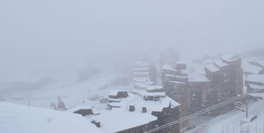
Updated: 6.15pm Tuesday 30 October 2018 - The big storm eases
The big storm that has been affecting the Alps since Saturday is now starting to die down. However, another is on its way for tomorrow, with the heaviest precipitation again forecast for the southern Alps.
 Lots of new snow in Saas-Fee this morning – 30 October 2018 – Photo: facebook.com/saasfee
Over the last 72 hours there has been some very wild weather across the Alps, especially yesterday which saw just about everything, including torrential rain, blizzards, hurricane force winds and even thunder and lightning.
Temperatures have also been all over the place in the last few days, generally lowest in the north-western Alps (e.g. Portes du Soleil) and highest in the south-east (e.g. Dolomites) but with huge variations from valley to valley, day to day and even hour to hour.
The high border areas between Switzerland and Italy have seen the most snow from this storm, with 1-2m of snow having fallen quite widely above 2500m, and very locally as much as 3m. This means a lot of snow (at altitude) for the likes of Zermatt, Saas-Fee, Cervinia, Monte Rosa, Madesimo, St Moritz, Livigno and Passo Stelvio – to name just a few.
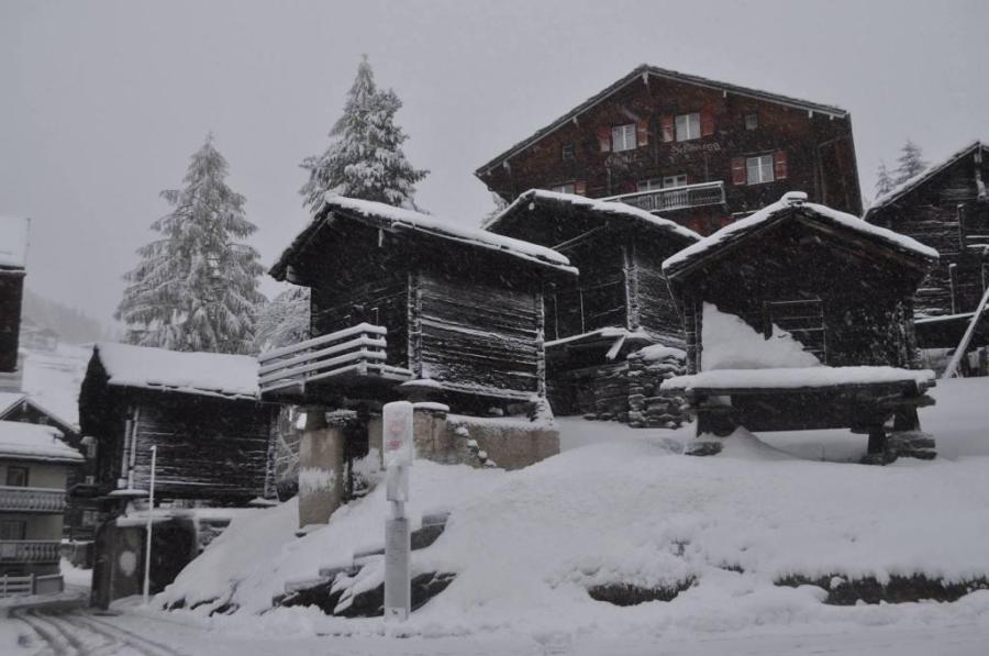
 New snow at Findeln just above Zermatt – 30 October 2018 – Photo: zermatt.ch
Most other parts of the Alps have also seen snow at high altitude but in more modest quantities. Lower down, due to the highly volatile temperatures (not to mention rain and warm Foehn winds in places) any accumulations of snow are likely to be temporary, especially below 2000m or so.
In conclusion, it’s a great start for the glaciers and for areas with plenty of skiing above 2500m, many of which could see a lasting base. For everyone else it is still all to play for, but that is exactly what you would expect at this time of year, so it is still way too early to be getting excited about snow conditions in general…
Updated: 12.50pm Sunday 28 October 2018 – The storm in the Alps continues
The Alps remain at the centre of the battleground between cold, relatively dry air coming down from the north and warm, very moist air pushing up from the Mediterranean.
 Massive snowfalls on the Passo Stelvio in the central Italian Alps – 28 October 2018 – Photo: stelvio.net
We have already seen a lot of precipitation this weekend across the Alps, albeit with a wildly varying rain/snow limit which has been as low as 600m (very locally) under the most intense precipitation.
More generally the limit has sat between 1000m and 1500m across the north-western half of the Alps, and between 1500m and 2500m across the south-eastern half.
 New snow in Ischgl – 28 October 2018 – Photo: ischgl.at
The heaviest snowfalls have been at high altitude in the southern French, Italian and southern Swiss Alps where some places have already seen between 50cm and 100cm above 2500m. But we haven’t seen the heaviest of it yet, with the precipitation expected to intensify across the southern Alps tonight and tomorrow.
 Snow in Avoriaz – 28 October 2018 – Photo: avoriaz.com
Indeed storm totals by Tuesday could be in excess of 2m in some of the high border areas between Switzerland and Italy, especially from Zermatt eastwards. Resorts which will benefit from these extreme snowfall totals include Zermatt, Saas-Fee, Cervinia and Monte Rosa. However, we should stress that the big totals will only be at high altitude, and not at or close to resort level.
We will report more fully on the consequences of this storm early next week…
Updated: 11am Saturday 27 October 2018 - Snow, rain, wind!
As expected, bad weather has arrived in the Alps today bringing a mixture of rain, snow and high winds.
 Heavy snow in Avoriaz this morning – 27 October 2018 – Photo: avoriaz.com
This is an extremely complex situation, with the battleground between cold arctic air from the north and warm Mediterranean air from the south situated right over the Alps. This will create huge variations in temperature and therefore rain/snow limits.
This morning, for example, the snow-line has already lowered to around 1300m across the north-western Alps, from the Portes du Soleil all the way to the Arlberg. By contrast, it is raining to around 2500m across the south-eastern half of the Alps including the Dolomites, for example.
 Snow to resort level in Lech this morning – 27 October 2018 – Photo: lech.com
Generally speaking, the heaviest precipitation will be in the southern and western Alps over the next few days, that’s to say the French Alps (especially close to the Italian border), the Italian Alps and the southern Swiss Alps.
Resorts which will see huge snowfall totals at altitude include Zermatt, Saas-Fee, Andermatt, Cervinia and Monte Rosa - all of which could see 1-2 metres of new snow above 2500m (with more in places) between now and Tuesday.
Many other parts of the Alps will also see snow, though with a highly variable rain/snow limit. This will generally be lowest in the north and west (e.g. Portes du Soleil) and much higher the further you are south-east.
We will bring you further updates tomorrow…
Updated: 10.30am Thursday 25 October 2018 - Severe weather on its way to the Alps
Earlier in the week we talked about a big change in the weather in the Alps this weekend. This is still very much on the cards, with a lot of rain and snow forecast from Saturday onwards.
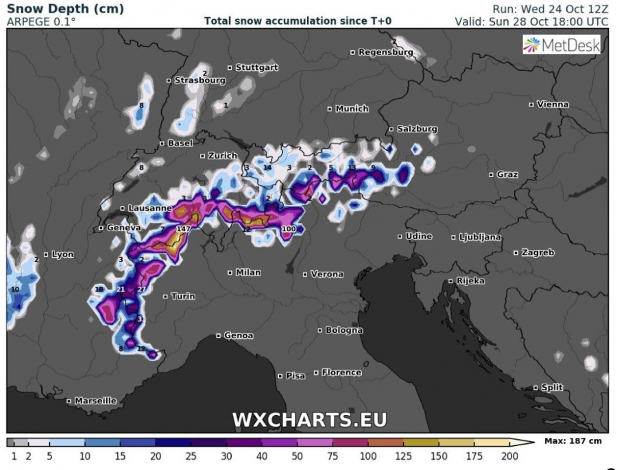 Total accumulated snowfall forecast by Sunday 28 October 2018 – Image: wxcharts.eu
There has already been some snow for the Austrian glaciers, with 30cm+ reported on the Kitzsteinhorn above Kaprun, for example. However, the main action is set to begin on Saturday when cold polar air arrives from the north and battles it out with warm Mediterranean air pushing up from the south. This battleground will be centred right over the Alps, meaning that there will be huge differences in temperature (and therefore rain/snow limits) from one area to the next.
The very highest precipitation totals look like being close to (and to the south of) the main Alpine ridge, in particular close to the Swiss-Italian border regions from about Cervinia/Monte Rosa eastwards through the Simplon and Gotthard regions, across towards St Moritz and Livigno, the Ortler and the Dolomites. These regions could see between 1m and 2m of new snow between Saturday and Monday at high altitude, but also lots of rain lower down.
Where the rain/snow limit will be situated is the big question, as it will fluctuate enormously at different times and in different places. Expect some surprises!
One thing we can be sure of though is that the warmer air will hang on longest in the south-eastern Alps (e.g. Dolomites), while the colder air will arrive quickest in the north and west (e.g. northern French Alps).
The weather also looks like it will remain very unsettled into the first part of next week, with further heavy rain and snow likely in many areas, probably favouring the southern and western Alps. Expect some really eye watering snowfall totals in places!
Stay tuned for further updates over the weekend…
Updated: 2.30pm Monday 22 October 2018 - Big snowfalls on the way?
So far it’s been a mild and relatively dry autumn in the Alps, but this is all about to change as a cold and potentially very snowy blast of arctic air is forecast for this coming weekend.
 GFS pressure chart for Saturday 27 October 2018 suggesting widespread snowfall across the Alps – Image: meteociel.fr
At this stage is impossible to be sure who will see the heaviest snow. Some weather models have the storm track moving across the centre of the Alps, meaning widespread dumps. Others have it a bit more to the west which would favour the western and southern Alps. Either way, we can now be fairly sure that we will see the first really significant snowfall of the season in the Alps, even settling to low levels in places too. We will bring you further updates as the week progresses - watch this space…
In the meantime, skiing in the Alps is still restricted to a handful of glaciers with the most extensive terrain (as is often the case at this time of year) in Austria’s Hintertux, with 28km of pistes in operation. Elsewhere in Austria you can ski on the glaciers at Kaprun, Stubai, Sölden, Pitztal, Kaunertal and Mölltal. You can also ski on a limited basis in non-glacial Kitzbühel thanks to their use of the “snow farming” technique, whereby old snow is preserved over the summer and re-used the following autumn.
In Italy you can ski on the glaciers at Val Senales and Passo Stelvio. In Switzerland you can ski in Zermatt and Saas-Fee. In France, you can only ski on the Grande Motte glacier above Tignes. Les 2 Alpes has had to cancel its usual half-term opening (for the second year running) due to the poor conditions on its glacier.
Updated: 10.30am Tuesday 16 October 2018 - Mixed fortunes for the Alpine glacier
It’s been a mild autumn so far in the Alps. While there has been a little high altitude snow at times over the last few weeks, it hasn’t been especially significant.
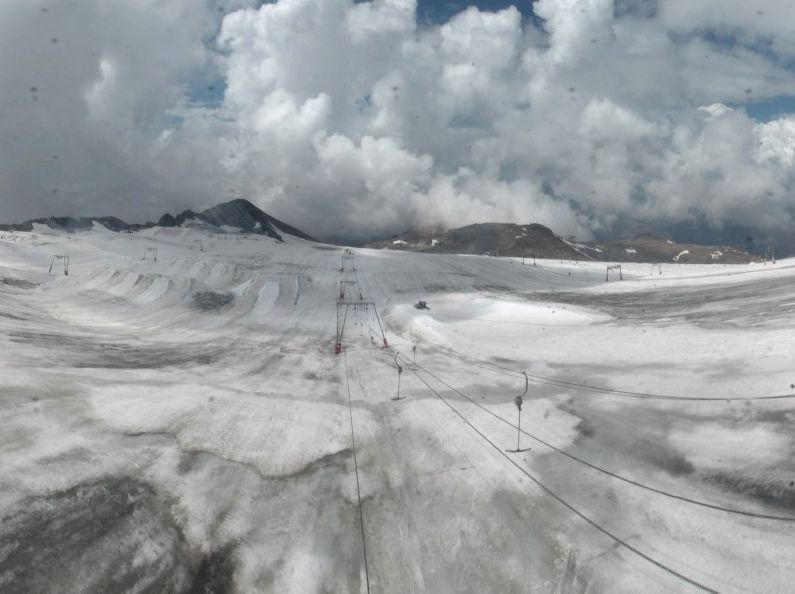 Precious little snow on the glacier at Les 2 Alpes – 16 October 2018 – Photo: les2alpes.com
After a torrid summer this is proving problematic in places, especially in France where Les 2 Alpes has announced (for the second year running) that there is insufficient snow on its glacier for it to open this half-term – which it had been able to without too much difficulty until recently.
Tignes is also suffering, with the opening dates for its Autumn ski season postponed indefinitely due to the poor conditions on its Grande Motte glacier.
Conditions are a bit better further east, though still not great, with Austria’s Hintertux continuing to lead the way with 21km of pistes currently available. Elsewhere in Austria you can ski on a more limited basis on the glaciers at Stubai, Kaprun, Pitztal, Kaunertal, Mölltal and Sölden.
You can also ski on a couple of non-glacial runs in Kitzbühel thanks to “snow farming” (as opposed to natural snowfall or the use of snow cannons) which Kitzbühel has been doing successfully for several years. Snow farming is the process of preserving some of the previous season’s snow over the summer by packing it densely then insulating it with wood chippings! This massively slows the rate of melting and the snow is then “spread” back over selected pistes in the autumn or early winter.
In Switzerland, you can ski on the glaciers at Saas-Fee and Zermatt, in Italy at Val Senales and Passo Stelvio. However, there is still no glacier skiing possible in France.
No significant new snow is expected in the Alps this week, with mild and sunny weather prevailing.
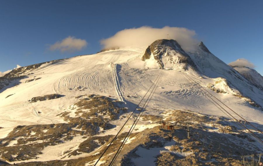
Updated: 8.45am Monday 8 October 2018 - A warm week ahead
Some parts of the Alps have seen a dusting of snow at high altitude over the weekend, but nothing significant. The week ahead will be on the warm side with a strong Foehn wind affecting the northern half of the Alps at times.
 The Grande Motte glacier above Tignes is still not open – 8 October 2018 – Photo: tignes.net
Most places will be dry this week, but some southern and south-western parts of the Alps will see a few showers (and a little high altitude snow but again nothing significant).
Wind permitting, you will able to ski on the following glaciers this week:
- in Italy - Val Senales and Passo Stelvio;
- in Switzerland - Zermatt and Saas-Fee; and
- in Austria - Hintertux, Stubai, Sölden, Pitztal, Kaunertal and Mölltal.
The Grande Motte glacier above Tignes does look a bit better than it did in September, but currently remains closed, meaning that there are not yet any skiing options in France.
Updated: 10.15am Tuesday 2 October 2018 - A little taste of winter
We have fresh snow in the Alps! It’s nothing to get too excited about yet – we are only just into October after all – but it has improved conditions on the glaciers, for a while at least.
 New snow at the mid-station in Hintertux – 2 October 2018 – Photo: facebook.com/hintertux.glacier
The improvement in conditions is down to a blast of cold and unstable polar air which has dumped 10-20cm of new snow (and 30cm+ in some favoured spots) at altitude across many northern parts of the Alps. Some snow also got through to the southern Alps, mostly the south-eastern Alps (e.g. Dolomites) though generally in more modest quantities.
From a skiing point of view, the areas that have done best from this storm are the Austrian glaciers, led by Hintertux where 10 lifts are currently serving 18km of pistes. Elsewhere in Austria you can also ski on the glaciers at Pitztal and Kaunertal, though on a more limited basis.
In Switzerland you can ski in Saas-Fee and Zermatt, neither of which saw more than a dusting from the recent storm. In Italy, the glaciers at Val Senales and Passo Stelvio saw a few centimetres of new snow, and have a handful of runs open.
 Fresh snow on the Grand Motte glacier, which remains closed for now – 2 October 2018 – Photo: tignes.net
There is still no skiing in France right now as, despite some snow having fallen on the Grande Motte glacier above Tignes it still hasn’t opened (it had been scheduled to open last Saturday).
The forecast for the Alps over the next few days is for the sun to dominate once more. Conditions on the open glaciers (especially the eastern ones) should remain pretty good, but any low-lying snow will quickly melt.
Updated: 9.30am Monday 1 October 2018 - Snow in the Alps!
It’s October, and what better time to kick off “Today in the Alps” - not least because there is some snow in the forecast.
 Fresh snow on the slopes above Ischgl this morning – 1 October 2018 – Photo: ischgl.com
Today’s bad weather comes courtesy of a cold front which is dragging unstable air across the Alps from the north. The heaviest precipitation will therefore fall across the northern Alps, especially in the north-eastern Alps (i.e. Austria). The rain/snow limit will fall steadily to reach as low as 1200m later in the day with between 10cm and 20cm of snow expected across the Austrian glaciers (such as Hintertux and Pitztal). The more western and southern glaciers (such as Tignes, Zermatt and Saas-Fee) will also see a little bit of snow but not quite as much as further north and east.
While new snow is welcome on the glaciers after another torrid summer, it won’t make much difference as to how the rest of the autumn pans out. High pressure will quickly regain control of the Alps this week with lots of dry and sunny weather in the forecast – at least once the last of the showers die away from the eastern Alps early tomorrow.
Once the current bad weather clears, the best skiing conditions in the Alps this week will be in Austria, especially on the Hintertux glacier. You can also ski in a much more limited capacity on the glaciers at Kaunertal and Pitztal.
In Switzerland you can ski on the glaciers in Saas-Fee and Zermatt, and in Italy at Passo Stelvio and Val Senales. However, France is not yet offering any skiing as the planned opening of the Grande Motte glacier above Tignes has been postponed due to poor snow.