


Updated: 9.40am Thursday 12 March 2020 – Warm today but snow for some parts of the Alps tonight…
It’s another very mild day today in the Alps, with freezing levels in excess of 3000m and maximum temperatures in some of the lower valleys in excess of 20°C!
 Plenty of snow in the high altitude Aletsch Arena but it will feel spring-like today – 12 March 2020 – Photo: bettmeralp.ch
Most places will be fine today, but cloud will increase in the north and west later in the day heralding the arrival of a cold front tonight. This front will bring 5-20cm of new snow above 2000m across the northern half of the Alps, heaviest in the north-west (northern French Alps). The rain/snow limit will start at or above 2000m but will descend towards 1000m later.
Tomorrow will see some showers (snow around 1000m) lingering for a time across the northern and north-eastern Alps (chiefly in Austria), while it brightens up further west. The southern Alps will see little, if any, snow from this front.
Updated: 1.40pm Wednesday 11 March 2020 - Very mild in the Alps following yesterday’s storm…
After yesterday’s storm delivered up to 40cm+ of snow to some parts of the Alps, it is a drier day today across the board. Some cloud is still lingering in the north-eastern Alps but it is otherwise mostly sunny with positively spring-like temperatures.
 Warm and sunny in Méribel this afternoon – 11 March 2020 – Photo: merinet.com
Yesterday’s bad weather came courtesy of a warm front which eventually affected most parts of the Alps. The snow was particularly heavy and persistent across the central and northern Alps, initially falling to low levels, but turning back to rain as high as 2200m in the north-west as the day progressed. The more enclosed central valleys (e.g. Valais), however, remained snowy to low altitudes for much of the day.
Over the next few days further undulating weather fronts will again affect the Alps, bringing showers or longer spells of rain/snow from time to time, but also some drier spells. Once again it won’t be particularly cold, with a rain/snow limit starting at around or above 2000m on Thursday, dropping a little on Friday.
With regards to snow conditions, there is still a lot of snow at altitude across the Alps but snow quality is likely to be variable (spring-like) below 2000m or so.
Updated: 10.00am Friday 6 March 2020 – Further snow parts of the Alps today…
It’s a complicated weather picture in the Alps today, with further snow for some areas (mostly in the north and east) and plenty of sun for others, particularly in the south and south-west. This follows a lot of snowfall across many parts of the Alps yesterday, but also some rain lower down, especially in the west.
 Fresh snow and bright skies expected today in Serre Chevalier – 6 March 2020 – Photo: facebook.com/Serre Chevalier
This morning we still have some persistent snow across the eastern Austrian Alps, with a rain/snow limit somewhere between 600m (in the north) and 1000m (in the south). We also have some snow flurries (600-800m) across the northern Alps, most of which are in the north-eastern Swiss Alps across into the Vorarlberg and Tirol.
As the day progresses, any snow in the eastern Austrian Alps is likely to die away, but snow flurries will continue from time to time across the northern Alps. These will turn a bit heavier tonight, by which point they will equally affect the northern French Alps (e.g. Portes du Soleil), the northern Swiss Alps (e.g. Engelberg), and the northern and western Austrian Alps (e.g. St Anton). Expect another 5-20cm of new snow above 1000m in these northern Alpine regions by tomorrow morning, with a bit more in places.
Most of the southern Alps will, by contrast, have fine weather today with some spells of sunshine.
Saturday will see further flurries to low levels across the northern fringes of the Alps, especially in Switzerland and Austria. Sunday will be mostly fine everywhere, although cloud will thicken in the north-west again later in the day as a new storm approaches, forecast to arrive overnight/on Monday.
Updated: 11.30am Thursday 5 March 2020 – Major new storm hits the Alps…
An active new storm has reached the Alps and is expected to bring significant new snow (but also some rain) to many regions in the next 24 hours, heaviest in the west.
 Heavy snow again in the French Alps, this is Val Thorens – 5 March 2020 – Photo: facebook.com/valthorens.resort
The first precipitation reached the western Alps (i.e. the French Alps) last night with a rain/snow limit briefly around or below 1000m. This morning the bad weather has extended across much of the western Alps and is starting to push into Austria.
The rain/snow limit is all over the place across the Alps today. It is still mostly quite low (600-1200m) in the central and southern Alps but is in the process of rising to between 1600m and 2000m in the more exposed mountains of the northern and western Alps (e.g. Portes du Soleil). It will peak this afternoon, before a cold front lowers the snow once again in the western Alps. By the end of the night the rain/snow limit will be between 600m and 1000m across most parts of the Alps.
Some northern and especially north-eastern parts of the Alps (e.g. Salzburgland) will be protected by the Foehn for much of the day, but rain or snow will eventually arrive here as well later in the day or overnight.
Much like the last storm, the most snow will fall in the northern French Alps (e.g. La Rosière, Flaine, Chamonix) where we will see between 30cm and 50cm of fresh above 2000m by tomorrow morning. The western Swiss Alps (e.g. Verbier) and the far north-western Italian Alps (e.g. La Thuile, Courmayeur) will see around 20-40cm of new snow, with most other part of the Alps seeing between 5cm and 30cm. The northern and eastern Austrian Alps will be the least favoured area but should still catch a few centimetres overnight and tomorrow.
Friday will generally remain mostly cloudy, with snow showers to relatively low levels across the northern half of the Alps but with better weather across the southern Alps, except in the Dolomites where some further flurries are expected.
Updated: 11am Wednesday 4 March 2020 - Mostly fine, new storm in the western Alps tomorrow…
There is quite a lot of cloud across the eastern Alps this morning, especially in the eastern Austrian Alps, with one or two flurries (700m) which will slowly die away. For most other parts of the Alps, it will be a dry day, with some lengthy spells of sunshine expected.
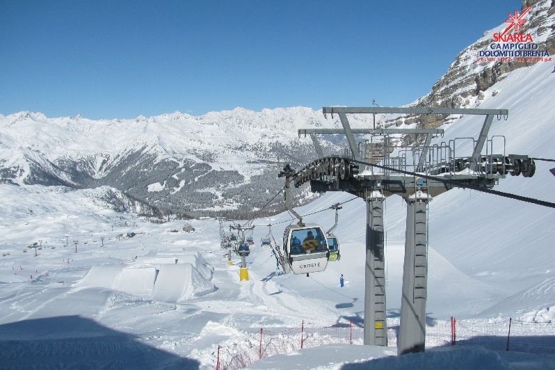 Lovely day in the Dolomites. This is Madonna di Campiglio – 4 March 2020 – Photo: funiviecampiglio.it
The next major storm will arrive in the western Alps tonight/tomorrow with significant snow at altitude both in the French Alps and some western Swiss resorts. The rain/snow limit will briefly rise to 1800-2000m in the west, before descending again to 1000-1200m late in the day.
We can expect 20-40cm of new snow above 2000m in the likes of the Paradiski, L’Espace Killy, the 3 Valleys and the Grand Massif, and perhaps 15-30cm in the likes of Verbier and the Jungfrau region. Most other parts of the Alps will also see snow on Thursday or Thursday night, with typically 5-15cm in the southern and eastern Alps (where the rain/snow limit will remain lower). The northern and eastern Austrian Alps (e.g. Salzburgland) will see the least snow from this storm.
Updated: 1pm Tuesday 3 March 2020 - Lots of new snow, especially in the southern and western Alps!
A lot of new snow has fallen across the Alps in the last 24 hours, with the heaviest falls in the southern and western Alps.
 Big snowfalls in the southern French Alps. This is how Serre Chevalier looked yesterday – 2 March 2020 – Photo: facebook.com/meteoalpes
The Italian Alps have done particularly well from the last storm, generally seeing between 30cm and 60cm of new snow above 1600m, but with 70cm or more in some parts of Lombardy and the Dolomites.
The French Alps (both north and south) have also seen big snowfalls, with 25-50cm falling quite widely, and as much as 70cm in places, notably close to the Écrins in the southern Alps (e.g. Serre Chevalier).
In Switzerland the heaviest falls were in the south-east, with around 50cm in the Engadin (e.g. St Moritz), while in Austria the far south (e.g. Nassfeld) did best this time around. The northern Austrian Alps have seen the least snow from this storm, with only 5-10cm of new snow in the Saalbach area, for example.
Back to today’s weather and there are still some snow showers to relatively low levels across the eastern half of the Alps, notably in Austria and the eastern Italian Alps. Further west, it is drier with some sunny spells but also a lot of cloud (and the odd flurry) drifting around.
Wednesday will a few further flurries here and there, but the next ‘major’ storm will hit the Alps on Thursday, with the heaviest snow set to fall in the western Alps, notably in France where another 50cm or more is expected at altitude.
Updated: 10am Monday 2 March 2020 - More heavy snow for some, including the southern Alps!
It’s a new week and a new storm is affecting the Alps, this time with the southern Alps set to see the heaviest snow, something we have not been able to say for quite some time.
 Heavy snow in the southern French Alps, for this first time in quite some time! This is Abriès – 2 March 2020 – Photo: queyras-montagne.com
There are two “hot spots” for the heaviest snow today, the first being the northern part of the southern French Alps, close to the Écrins and including resorts such as Alpe d’Huez and Les 2 Alpes. The second area, set to see the heaviest snow tonight, is the eastern Italian Alps from about Livigno eastwards, including resorts such as Passo Tonale, Madonna di Campiglio and Arabba in the Dolomites. Both could see in the region of 30-50cm of new snow (with even more in places) by tomorrow morning.
The northern Alps will also see some snow, although protection by the Foehn may allow the weather here to stay dry and bright for a time today, possibly even all day in the north-eastern Alps (e.g. Salzburgland). France will see the most snow, with another 20-35cm possible at altitude by tomorrow morning in the likes of L’Espace Killy, the 3 Valleys and the Grand Massif.
The rain/snow limit today will vary across the Alps, but will typically start at around 1200-1500m before falling to below 1000m later, falling lowest in the north-western Alps.