


ARCHIVE
Today in the Alps - February 2024
Read about current weather and snow conditions in the Alps
Updated: 8.30am Tuesday 27 February 2024 – More snow for some, mostly in the south…
An area of low pressure is currently centred over the Mediterranean, not far from Corsica. This will only drift very slowly southwards over the next couple of days, and this type of weather set-up means snow for the south-western Alps, with the most set to fall in the southern Italian Piedmont (e.g. Prato Nevoso, Bardonecchia, Sestriere) where 40cm+ is likely in the next 24-36 hours alone.
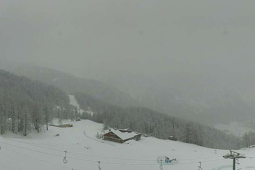 That’s more like it! Looking much wintrier in Bardonecchia in the Italian Piedmont, with more snow on its way – Photo: bardonecchia.it, 27 February 2024
Other resorts that should do quite well are those very close to the southern French/Italian border, such as Isola 2000, the Queyras and Montgenèvre and, to a lesser extent, Val Cenis and Val d’Isère/Tignes.
Some useful, but not exceptional falls, are also expected a bit further north and east, in Pila, Cervinia, the Monte Rosa region and over the border in Zermatt and Saas-Fee. There will also be some moderate snowfalls right across the central/eastern Italian Alps, including in Livigno, Passo Tonale and the Dolomites. The extreme north-west of Italy (Courmayeur) and, more generally, the northern half of the Alps will see little or no snow, however.
Later this week a new storm will approach the Alps from the west, which is expected to deliver further snow, probably again favouring the southern Alps but perhaps also the west.
As for snow conditions in the Alps, they remain considerably better than they were a week or two ago and some resorts now have plenty of fresh snow to enjoy. However, many lower altitude areas are still struggling with a meagre, broken or even non-existent natural base, which is very difficult to rebuild at this stage of the season.
Updated: Friday 23 February 2024 - Snow in the Alps!
It’s a mostly cloudy day across the eastern Alps today, with snow at times, heaviest in the south-east (e.g. Carinthia, Dolomites). In the western Alps (e.g. France) it is brighter with sunny spells.
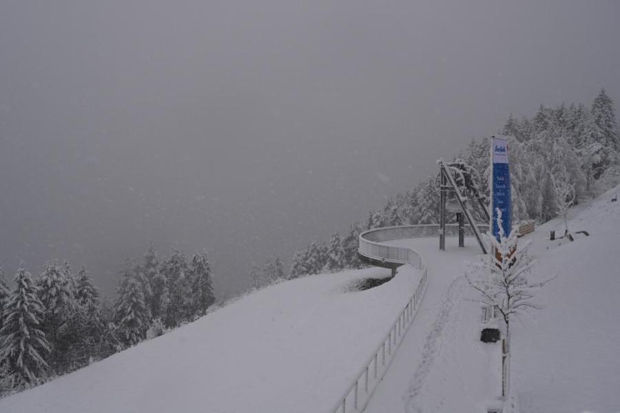 Snowing in the eastern Alps today. This is Seefeld in Austria – 23 February 2024 – Photo: foto-webcam.eu
This latest storm hit the western Alps yesterday but started with a relatively high rain/snow line (around 1600-2000m) before it turned much colder overnight. This morning, around 15-30cm of new snow has fallen above 2000m across much of the French, Swiss and north-western western Italian Alps with a few centimetres at lower altitudes too.
Today the region that will see the most snow is the south-eastern quarter of the Alps, including the Dolomites (e.g. Arabba), southern Austria (e.g. Nassfeld), Lombardy (e.g. Livigno) and the far south-east of Switzerland (e.g. St Moritz). By tomorrow morning these areas should see between 30-50cm of fresh snow at altitude, with up to 60cm in places.
Updated: 11.25am Wednesday 21 February 2024 – Snow on its way for the Alps, but how much?
High pressure is slipping away to the south-east of the Alps allowing Atlantic weather fronts to invade from the west. Most of the Alps can expect at least some snow over the next few days, but it now looks like the southern Alps will do best.
 Milky skies this morning over the northern French Alps, heralding the arrival of a new storm cycle that will affect the Alps over the next few days. This is Les Saisies – Photo: lessaisies.com, 21 February 2024
Today it will remain mostly dry, bright and mild across the Alps. However, there are some areas of cloud drifting around, and some more general high cloud spreading into the west ahead of the approaching storm. This cloud will thicken overnight with a few showers here and there across the western Alps, and a rain/snow limit between 1700m and 2000m.
Thursday will be a messy weather day across the western half of the Alps – mostly cloudy with bits and pieces of rain/snow but also some drier interludes. It will remain very mild with the rain/snow limit around 2000m in the far western Alps, but a bit lower (1300-1600m) in the more internal valleys (e.g. Haut-Valais). The eastern half of the Alps will remain mostly dry until evening.
Late on Thursday, a much more powerful cold front will reach the western Alps before moving east overnight to reach all the eastern Alps early on Friday. It will also turn colder, with the rain/snow limit dropping to 400-800m by the end of Friday.
Between now and Saturday morning we can expect between 15cm and 30cm of new snow above 1500m across most of the Alps, but 40- 50cm or even more across some central-southern and south-eastern regions such as St Moritz, Livigno, Passo Tonale and Cortina.
Looking even further ahead, it seems likely that the weather in the Alps will remain cool and changeable early next week with further snow for some, the heaviest of which will again fall in the southern Alps.
Snow conditions will obviously improve in many areas over the next few days, particularly in the southern Alps. However, the lack of snow at low altitudes remains an issue and at this time of year it takes a lot of snow to rebuild any base. We will take a closer look at this in our detailed snow report out tomorrow…
Updated: 9.50am Monday 19 February 2024 – The weather pattern in the Alps is changing…
The weather in the Alps is changing, with significant snow likely to fall across much of the Alps by the weekend. Indeed, some weather fronts are already affecting the northern Alps, which will deliver some snow today in two phases.
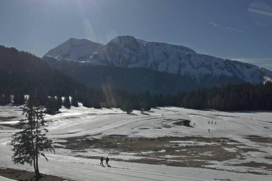 The snowpack is now thin on the cross-country trails in Chamrousse near Grenoble, though snow is on its way here later this week – Photo: chamrousse.com, 19 February 2024
The first phase of snow is arriving in the northern Alps this morning, before a second, more significant, phase comes this evening and overnight. The eastern Swiss and western Austrian Alps (e.g. Arlberg) will benefit most, with between 15-25cm of new snow above 1700m with a rain/snow limit initially around 1400-1600m but falling towards 1000m tonight.The north-western Alps (e.g Verbier, Avoriaz, Val d’Isère) will see less snow, with just a few centimetres at best.
Tuesday will see some flurries linger across the north-eastern Alps for a time, otherwise most places will remain dry.
The big storm cycle that has got everyone talking will then start to make its presence felt late on Wednesday and will continue to influence the weather in the Alps for several days. Most of the precipitation will initially fall in the western Alps, with the eastern Alps also getting involved by Friday. The rain/snow limit will be rather high to start with, typically between 1500m and 2200m on Wednesday night and at first on Thursday, before falling to lower levels late on Thursday and on Friday.
The weather will then continue very unsettled through the weekend by which point most of the Alps should have seen significant snow, at least at altitude. Temperatures won’t be that cold though (at least not yet), meaning that lower areas will again be troubled by rain at times, at least early on in this storm cycle. This should become less of an issue by the weekend when the cooler air will be more embedded.
Updated: 10.15am Wednesday 14 February 2024 – Mostly fine and mild in the Alps…
High pressure is currently in charge of the weather in the Alps, meaning that most areas will be fine and dry today with plenty of sunshine. That said, there are some areas of cloud floating around, most prevalent in Austria. It will be mild everywhere.
 The Arlberg is one area that has had plenty of snow this season. This is St Anton – 14 February 2024 – Photo: foto-webcam.eu
It will remain mild and mostly fine in the Alps for the rest of this week, however, weak weather fronts will never be far away from the north, and these will finally introduce some showers or flurries to some northern areas by the weekend. Significant snow is not expected until the weekend of 23-25 February at the earliest though.
Snow conditions remain mixed across the Alps, generally with plenty of snow at high altitude, especially in the northern Alps (e.g. Tignes, Lech, Obertauern) but little snow lower down for the time of year. Most resorts can still offer plenty of piste-skiing, but serious off-piste opportunities remain limited.
Updated: 1.40pm Monday 12 February 2024 – Still changeable in the Alps…
The weather in the Alps remains changeable, with flurries to relatively low levels today across some northern regions, especially Austria, though not generally amounting to much. Most other parts of the Alps will be dry with variable cloud cover and the best of any sunshine in the south.
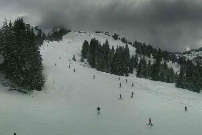 Modest snow cover but still plenty of reasonable piste-skiing in Les Gets – 12 February 2024 – Photo: lesgets.com
On Tuesday, most of the Alps will be dry with variable cloud cover, but a weak warm front will skirt the northern Alps later in the day with some light rain or snow in places (with the rain/snow limit rising to 1800m on Tuesday night).
Snow conditions in the Alps remain rather mixed, generally now best in the southern Alps (e.g. Isola 2000, Monte Rosa region) which saw most of the weekend’s snowfalls. Accumulations from this last storm were more modest in the northern Alps, but there is still plenty of reasonable piste-skiing to be found, especially at higher altitudes. However, natural snow cover generally remains unusually patchy at low altitude.
Updated: 11.40am Friday 9 February 2024 - New storm has arrived, favouring the south-western Alps…
The weather in the Alps has turned more unsettled with the arrival of a new storm from the south-west. Most of the Alps will see at least some snow over the next couple of the days, with two distinct parts of the south-western Alps set to be the most favoured.
 Worryingly thin snow cover lower down in Bardonecchia in the Italian Piedmont, though there will be an improvement over the weekend, albeit only temporary – Photo: bardonecchia.it, 9 February 2024
The two areas set to see the most snow from this storm are firstly the far southern French Alps (e.g Isola 2000), stretching just over the border into Italy (e.g. Prato Nevoso) and, secondly, a narrow sector of the central-western Italian Alps including the eastern Monte Rosa (e.g. Alagna), a little further east (Macugnaga) and over the border into the far south of Switzerland (e.g. Bosco Gurin). All these areas should see at least 30cm of new snow above 1800m by Sunday morning, perhaps a bit more, though this is a bit less than had been hoped for just a day or two ago.
Elsewhere in the Alps there will also be some snow, but generally in quite modest quantities. Expected snowfall totals between Friday and Sunday (above 1800m) include: 20cm in St Moritz; 15cm in Sestriere, Val d’Isère, Zermatt, Obergurgl and Verbier; 10cm in Avoriaz, Lech and Selva; and 5cm in Kaprun.
The rain snow limit during this storm will start at around 1500-1800m but will drop towards 1000m later in the weekend.
Snow conditions will clearly improve in most parts, at least above 1500m or so, but this is not really the game-changing storm hoped for, and snow remains very thin, patchy or non-existent at low altitudes.
The most solid bases are to be found at altitude in the northern French Alps (e.g Tignes, Val Thorens), the Arlberg (e.g Lech, St Anton) and in other high Austrian resorts (e.g. Obergurgl, Obertauern).
Updated: 9.40am Wednesday 7 February 2024 - Taste of winter on its way for most of the Alps…
The good news is that temperatures are set to turn a bit colder in the Alps later this week and over the weekend, with some snow in places. However, the snow is sadly not going to be quite as heavy or as widespread as was hoped a few days ago, with some places probably not seeing very much at all.
 Isola 2000 in the far southern French Alps has not seen much snow this season but should be in the sweet spot for the upcoming storm, with at least 50cm of snow expected between Thursday night and Saturday – Photo: isola2000.com, 7 February 2024
Today will be mostly fine and mild across the Alps, with some long sunny spells. However, cloud will thicken across the far northern Alps later in the day, with a little rain or snow falling overnight close to the foothills of the French (e.g. Avoriaz), Swiss (e.g. Engelberg) and perhaps the far western Austrian Alps (e.g Lech). The rain/snow limit will rise from 1400m to 1800m, with a maximum of 2-5cm of new snow.
Any showers in the far northern Alps will die away on Thursday, leaving most areas with a dry day with sunny spells. However, cloud will thicken up in the south-western Alps (e.g. Isola 2000) later, heralding the approach of the next, more significant storm. This storm will continue to influence the weather in the Alps into the weekend, most favouring the south-western Alps.
The two areas that should do very well from this storm include the far southern French Alps (e.g. Isola 2000, Auron) where 50cm or more is quite likely between Thursday night and Saturday afternoon. The second is a portion of the Italian central-western Italian Alps, roughly between Cervinia and Madesimo (including the Monte Rosa region) where 30-50cm is likely.
Most of the rest of the Alps will also see some snow but generally in lesser quantities, with typically 10-20cm, with the higher totals falling in the northern Alps (e.g. Avoriaz, Engelberg, Lech, Kaprun) falling later in the weekend.
During this storm the rain/snow limit will generally start at around 1500-1800m in the southern Alps overnight on Thursday, before gradually falling towards 1200-1500m on Friday. In the northern Alps it will also start at around 1500-1800m, but on Saturday, before falling towards 1000m on Sunday.
The upcoming snow will be very welcome for those resorts that get it in any significant quantity. However, except in a few lucky resorts in the south-western Alps (e.g. Isola 2000, Monte Rosa), it is unlikely to significantly alter the situation for long. This is due to the serious lack of snow at low altitudes across the Alps, for which big back-to-back storms are needed to radically transform the situation and relay the base – an increasingly tricky task at this time of year when the sun’s strength increases.
In terms of how the weather in the Alps will pan out for the big February half term week next week, there remains a lot of uncertainty, with a little more snow possible but not in the really big quantities that are needed right now.
Updated: 10am Friday 2 February 2024 - Return to winter within sight?
The weather in the Alps has been far too warm in recent days. Yesterday a weak front delivered a few centimetres of snow to some higher parts of the northern Alps, mostly in Austria, but it has now been some time since there has been any significant widespread snowfall.
 Engelberg sums up the situation in the Alps quite nicely right now with plenty of snow on the upper half of the mountain but precious little lower down – 2 February 2024 – Photo: titlis.ch
Indeed, much of this week has been positively spring-like, with freezing levels above 3000m at times and maximum temperatures reaching the high teens in some of the lower valleys.
Snow depths remain healthy at higher altitudes across the northern Alps, including in the high French resorts (e.g. Val d’Isère, La Plagne, Val Thorens), the higher areas of many Swiss resorts (e.g. Verbier, Engelberg, Davos, Laax) and the higher Austrian resorts (e.g. Arlberg, Ischgl, Obergurgl, Obertauern).
Lower down, however, natural snow is much more modest or non-existent right across the Alps, including at resort level in the likes of Morzine, Gstaad, Grindelwald and Zell am See. The lower slopes of many southern Alpine resorts are also patchy.
In short, there is still plenty of piste-skiing on offer right across the Alps, but the quality is variable. Above 2000m or so the snow is often quite reasonable but lower down it has either been icy or in some cases slushy, especially on slopes exposed to the sun.
Looking further ahead, although it will be very mild again over the next few days, the various weather models are fairly consistent in forecasting the introduction of some notably colder and snowier weather just in time for half term. It’s a long way off, but fingers crossed...