


Updated: 9.30am Wednesday 30 September 2020 - Major new storm set to hit the Alps…
The weather in the Alps is mostly fine today, with the best of any sunshine in the west. A new storm will approach from the west tomorrow, heralding a very unsettled spell of weather in the Alps, this time bringing the heaviest precipitation to the southern and western Alps.
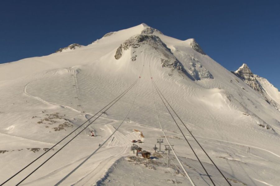
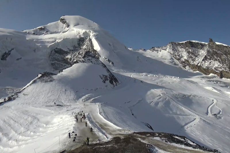 Major new snowfalls expected for the glacier at Saas-Fee which is already skiing well – 30 September 2020 – Photo: saas-fee.ch
The first showers will affect the high border areas between France and Italy, and particularly France and Switzerland (especially the Simplon region) later tomorrow with a rain/snow limit around 2500m. On Friday showers will become more widespread across the French, Italian and southern Swiss Alps while many northern and especially north-eastern parts of the Alps will remain dry under the influence of the Foehn.
The heaviest precipitation will again fall along the Italian-Swiss border, especially at altitude between Zermatt and the Italian Lakes. The rain snow limit will generally sit between 2500m and 3000m, but possibly a little lower on the southern side of the main Alpine ridge under some of the heaviest precipitation.
The weather will continue to be unsettled over the weekend with further rain or snow in places, always heaviest in the southern French, southern Swiss and Italian Alps, and lightest and patchiest in the northern and eastern Austrian Alps. The rain/snow limit will be variable but will tend to lower towards 1500m, at least in the western Alps.
This new storm is particularly good news for the glaciers at Zermatt and Saas-Fee, both of which are open for skiing and could see as much as 1m of new snow by the end of the weekend.
Further east the glaciers at Val Senales and Passo Stelvio are also open, and will also see a significant dump of snow, but most of the Austrian glaciers will only see a modest top-up this time around.
Updated: 10.30am Tuesday 29 September 2020 - Turning milder in the Alps but with a new storm to end the week…
After last weekend’s big snowstorm, the weather in the Alps is turning milder again with freezing levels expected to rise to around 3000m by tomorrow.
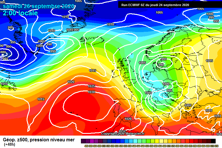
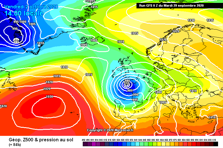 New storm due at the end of this week, this time favouring the south-western Alps for precipitation – Image: meteociel.com, 29 September 2020
However, a major new storm is forecast for the end of this week, this time set to hit the southern and western Alps hardest. Temperatures won’t be as cold as last weekend, but significant snowfall is expected at altitude in places between Thursday and Saturday, especially in parts of the French Alps (e.g. Les 2 Alpes), the Italian Alps (e.g. Cervinia) and parts of the southern Swiss Alps (e.g. Zermatt and Saas-Fee).
The rain/snow limit is expected to mostly stay between 2000m and 2700m during this storm but will lower to 1500m or so in places on Saturday.
Updated: 5.30pm Sunday 27 September 2020 – Record-breaking early snowstorm now fizzling out…
The next day or two will see a few showers here and there, with a few more centimetres of snow at altitude in one or two spots, but for all intents and purposes the big September storm is now over. What a storm it was though, bringing some of the heaviest and lowest snowfalls ever seen in the Alps at this time of year.
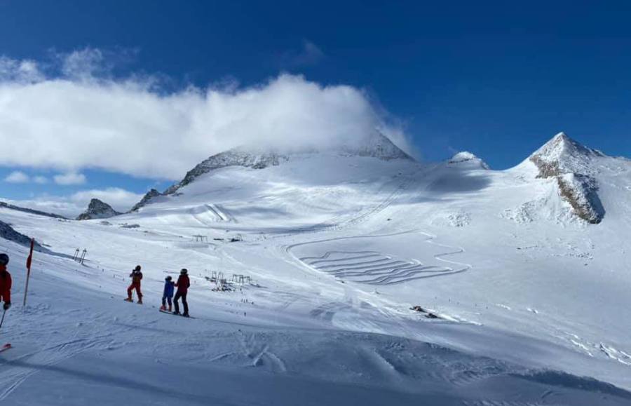 Perfect snow conditions on the Hintertux glacier today – 27 September 2020 – Photo: facebook.com/Hintertux.gletscher
Over the last couple of days, the northern Alps have generally seen between 15cm and 40cm of new snow at 2000m, with 40cm to 70cm above 2500m, and close to 1m in some western parts of Austria. The snow is very windblown in places though, so it may not necessarily look like this much has fallen in some of the more exposed areas.
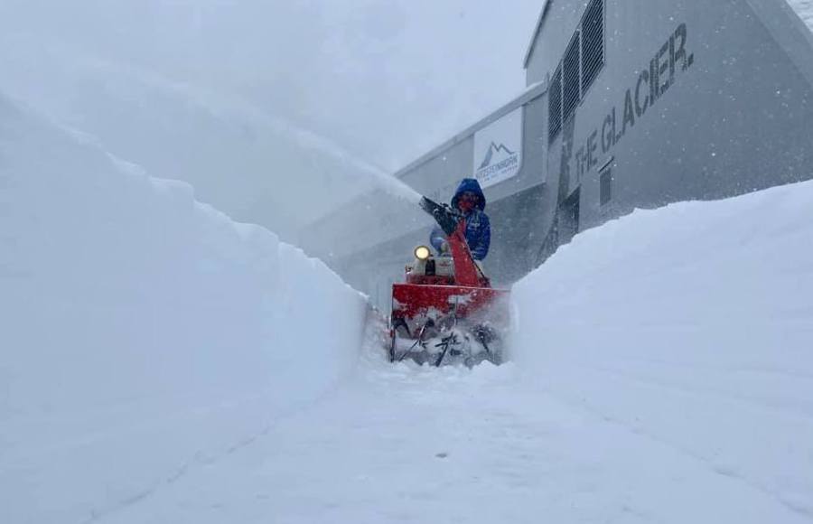 Deep snow on the Kitzsteinhorn glacier about Kaprun – 27 September 2020 – Photo: facebook.com/Kitzsteinhorn
What is most remarkable about this storm is just how low the snow has fallen, with reports of wet snow to as low as 550m across some northern fringes of the Alps (e.g. the German/Austrian border). Several records were also broken, including 25cm of fresh snow in Crans Montana, Switzerland (1500m), never seen before in September.
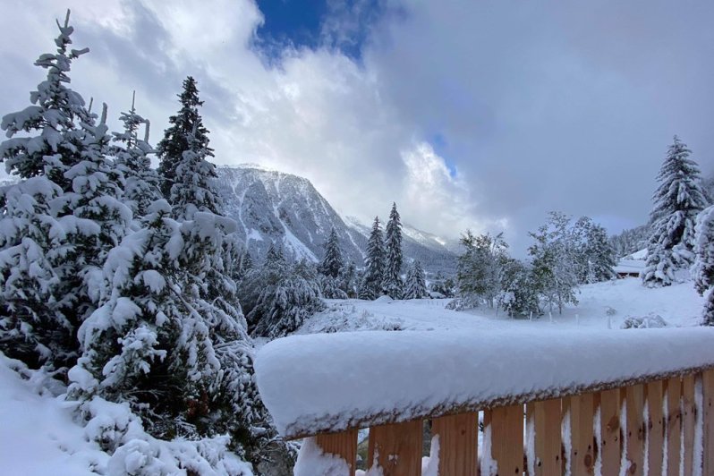 Wintry scenes in Pralognan La Vanoise – 27 September 2020 – Photo: twitter.com/Pralognan
The big question though is what this means for the season as a whole? The short answer is unfortunately not very much. At this time of year you would need multiple dumps to stand a chance of building a base at most skiing altitudes, and you would have to go back to the 1970s to find a winter where a base of any note had been built so early in the year.
That said, while the snowline will scurry back up the mountain over the next few days, it won’t all be wasted as snow conditions on the glaciers will be excellent once the weather settles down.
We will bring you more on where is open and where is best to ski in October tomorrow…
Updated: 11.30am Saturday 26 September 2020 – Winter wonderland in many parts of the Alps…
As expected, there is a lot of fresh snow across the Alps this morning. The heaviest snow has fallen across the northern half of the Alps, where some favoured spots have already seen more than 60cm at altitude.
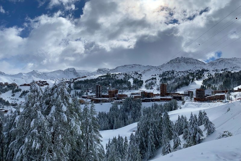 Winter wonderland in La Plagne this morning – 26 September 2020 – Photo: facebook.com/LaPlagne
The northern half of the Alps has generally seen between 15cm and 40cm at 2000m, and 30-60cm at 2500m. By the end of the weekend some areas could see 80cm or more at altitude.
Not only is the amount of snow that has fallen unusual for September, but the drop in temperature is also quite remarkable, with snow falling to 700m across some northern fringes of the Alps. Most southern Alpine resorts have also seen some snow, but generally in more modest quantities.
Today will remain very cold with further flurries (900-1200m) across many northern parts of the Alps, heaviest and most persistent across the eastern Swiss and western Austrian Alps (e.g. Arlberg).
Further snow showers are forecast in places on Sunday and Monday, after which Tuesday will see a return to milder and more settled weather in the Alps.
We will bring you a full round-up of the winter storm tomorrow (Sunday).
Updated: 10.30am Friday 25 September 2020 - Here comes the snow!
As forecast, winter has arrived in the Alps, with close to 1m of new snow possible at altitude across some favoured parts of the northern Alps by Sunday.
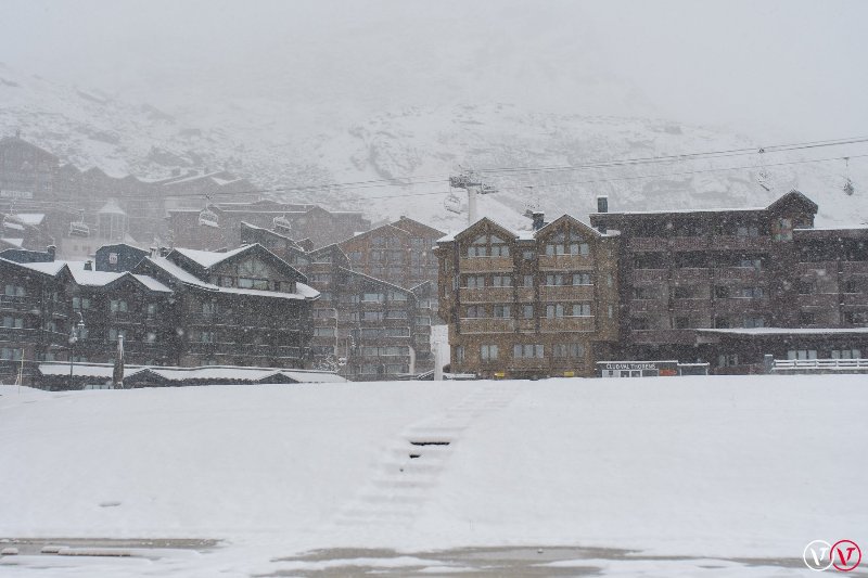 Early snowfall in Val Thorens – 25 September 2020 - Photo: facebook.com/Valthorens.resort
This morning there is already a significant covering of snow at altitude, especially across the northern Alps where the temperature has dropped by some 15°C over the last couple of days. After a relative lull this morning in the western Alps, the weather will close in again later today with heavy and persistent snow expected to fall to increasingly low levels this evening and overnight across much of the northern Alps. Areas set to benefit include the French Alps north of Grenoble (e.g. Tignes, Chamonix, Avoriaz), most of the Swiss Alps (e.g. Verbier, Mürren, Engelberg, Davos) except Ticino and some parts of the Engadin, and the Austrian Alps (excluding the Osttirol and Carinthia).
Much of the northern half of the Alps will see between 35cm and 70cm of new snow above 2500m by the end of Saturday, with up to 1m possible in some favoured spots. The rain/snow limit will descend to as low as 1000-1200m later tonight and tomorrow (and as low as 800m in places close to some northern fringes of the Alps), which is very unusual for September.
Most southern parts of the Alps will also see some snow at altitude but generally not as much as further north. Two southern Alpine resorts that could do better than most are Cervinia and Livigno, where 15-30cm of new snow is possible at altitude.
The big question though is whether all this early snow make any difference to the main season ahead? The short answer is probably not, although it is fantastic news for the glaciers, more and more of which are planning to open over the coming days/weeks.
Some of this snow may also stick around until winter on higher, north facing non-glacial slopes. However, for the majority of resorts, most if not all of the snow will disappear again UNLESS multiple new snowfalls compound the first fall, which is not currently forecast in the medium term weather charts.
So, if you are lucky enough to be in the Alps right now, enjoy it if you can! There will certainly be some amazing snow conditions on offer on the glaciers over the next few days/weeks once the weather settles down…
Updated: 9.30am Thursday 24 September 2020 - Arctic blast incoming!
A spectacular change is expected in the weather in the Alps over the next 24 hours, as increasingly frigid air is pulled down from the Arctic. Not only will it turn much colder, but there will also be a lot of snow, especially in the northern Alps where it could fall to 1000m or lower by Saturday!
 Surface pressure chart showing a cold and dynamic Arctic airflow over the Alps on Saturday 26 September 2020 – Image: meteociel.com, 24 September 2020
September snow may not be unusual in the Alps, but it is usually a fleeting, high altitude affair, disappearing as quickly as it arrives. This will be different, though, and is certainly the most significant September snowfall in the Alps since Weathertoski began back in 2012.
The first weather fronts will arrive on Thursday but, with the air already in situ over the Alps being relatively warm, the rain/snow limit will initially start high (somewhere between 2700m and 3000m). This limit will lower later today and tonight, with snow expected to fall to between 1400m and 1800m on Friday morning, then down to 1100-1400m by Friday evening.
With even colder air digging in on Friday night and Saturday, snow may fall to 1000m or lower across some northern fringes of the Alps by Saturday morning.
Although most southern parts of the Alps will see at least snow some at altitude over the next few days, by far the heaviest snow will fall across the northern half of the Alps where between 40cm and 60cm of new snow will have fallen quite widely above 2500m by the end of Saturday.
Some favoured spots could even see close to 1m of new snow at altitude, with a dusting to as low as 1000m in places. Resorts in the northern Alps that will see significant snow at altitude over the coming days (even if they are all currently closed) include Tignes, Chamonix, Flaine, Verbier, Mürren, Engelberg, St Anton and Kaprun.
The snow forecast from this storm is especially welcome for the glaciers, which are often at their most threadbare in September. The Grande Motte glacier above Tignes (due to open on 17 October), for example, will see at least 50cm of new snow, almost certainly enough to ensure a good start to their ski season. Most other glaciers will also benefit to varying degrees, including some that are already open such as Zermatt (where 20-30cm of new snow is expected), Saas-Fee (where 20-30cm of new snow is expected) and Hintertux (where 40-50cm of new snow is expected).
Of course, with all the forecast snow, it is essential that those planning to either drive or walk in the Alps over the next few days (especially in the northern Alps) are adequately prepared.
We will bring you further updates on this unusually potent early winter storm over the next couple of days.
Updated: 10am Tuesday 22 September 2020 - Big early snowfalls on their way to the Alps!
Fasten your seatbelts! A dramatic change in the weather in the Alps is expected by the end of this week, with temperatures set to drop by at least 15°C and heavy snow falling to relatively low levels, especially across the northern Alps.
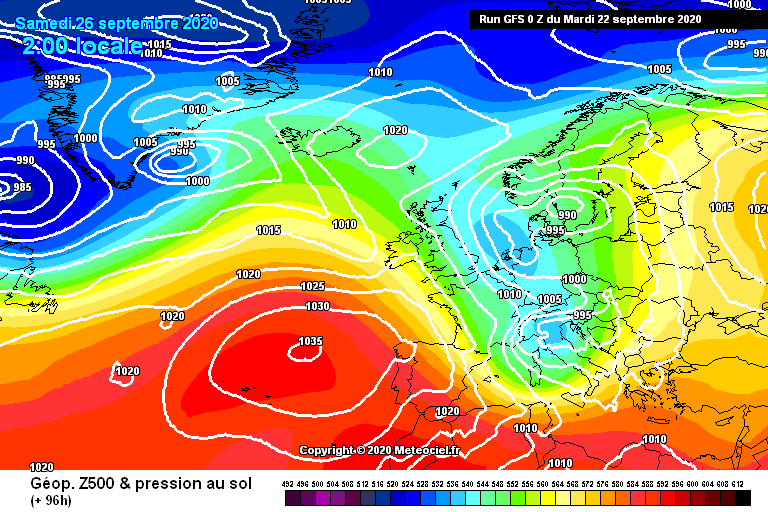 Major Arctic blast set to hit the Alps this weekend (26-27 September), bringing significant snow to many parts of the Alps, especially the north – Image: meteociel.com, 22 September 2020
This change comes courtesy of a series of cold fronts that will drag colder and colder air down from the Arctic. The drop in temperature will start to be noticeable on Thursday, when the rain/snow limit will initially start at around 3000m, before dropping towards 2000-2300m later in the day. On Friday, the snowline will lower to 1200-1500m across the northern Alps, then to below 1000m in places on Saturday!
By Sunday we can expect 30cm to 60cm of new snow above 2500m quite widely across the northern half of the Alps (e.g. Tignes, Chamonix, Verbier, Mürren, Engelberg, St Anton), with 75cm or more in some favoured spots such as the Austrian Arlberg (St Anton, Lech, Zürs). Significant accumulations to lower levels are also likely for a time, with a dusting possible to as low as 700-900m in places on Saturday!
Many southern Alpine resorts will also see some snow (with 30cm or more possible at altitude in resorts such as Livigno and Passo Tonale), but generally not in the same quantities as further north.
Modest September snowfalls are quite common in the Alps, but a winter storm as potent as the one we are expecting later this week is relatively rare and certainly not something that you see every year. But before you get too excited, it is still unlikely to mean much in terms of how the rest of the Autumn, or indeed winter will pan out.
This week’s storm may bring enough snow for some or even most of the glaciers to set up a good “wintry” base for the autumn, but below glacier level most of the snow would be expected to disappear again fairly quickly.
That said, some weather models are suggesting that another big winter storm could arrive from the north in early October. If that does materialise, this could lead to some sort of lasting base in places above 2200-2500m. Watch this space!
Updated: 10.30am Wednesday 16 September 2020 – Warm weather in the Alps this week…
The weather is pretty warm this week across the Alps, with September continuing the trend from summer, when temperatures were again above average, and August proved exceptionally hot overall.
 Saas-Fee is one of only two skiing options open in Switzerland right now – 16 September 2020 – Photo: saas-fee.ch
Skiing conditions on the glaciers were generally good early in the summer season, thanks to the impressive snowfalls at high altitude last winter, but they deteriorated quite markedly later in summer, especially in France - a recurring theme in recent years. That said, summer skiing conditions in the Alps were slightly better overall this year than in 2019.
Mid-September is one of the quietest periods for skiing in the Alps, with only a handful of glaciers open. In Austria you can currently ski on the Hintertux glacier where the snow is 65cm deep and 20km of pistes are open. In Italy you can ski on the Stelvio glacier (9km of pistes, 155cm snow depth), while in Switzerland you can ski in Zermatt (15km of pistes and 220cm snow depth) and Saas-Fee (20km of pistes, 200cm snow depth).
France currently has no lift-served skiing open, although Tignes hopes to commence skiing on its Grande Motte glacier on 17 October 2020.
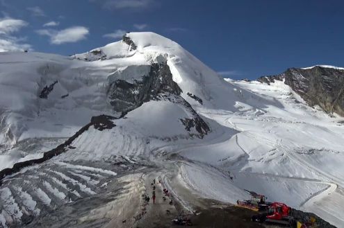
Updated: 10am Tuesday 9 June 2020 - Fresh snow for the glaciers…
The weather in the Alps is currently very unsettled with significant fresh snow at high altitude, and a dusting as low as 1000m in places in south-east Switzerland.
 Fresh snow on the Corvatsch mountain near St Moritz – 9 June 2020 – Photo: corvatsch.ch
Fresh snow is not uncommon at high altitude in the Alps in June but it is nonetheless great news for the summer ski season which is already underway in a number of resorts (see our post from 4 June below for more details about where is open when).
The snow that fell to 1000m was confined to a specific valley in the Swiss canton of Graubünden, but over the last couple of days the rain/snow limit has more generally been oscillating between 1700m and 2500m, with between 10cm and 30cm of fresh snow falling above 3000m across much of the Alps.
The weather in the Alps will remain rather unsettled for the foreseeable future, with showers and an increasing risk of thunderstorms as it turns warmer later in the week.
If you are lucky enough to be based in or near the Alps and can visit a summer ski area this week, you will need to pick your moment - Friday is likely to be the best weather day overall.
Updated: 10.30am Thursday 4 June 2020 – Latest news on summer skiing in the Alps…
While many people’s plans for summer skiing in the Alps this year may be hampered by restrictions on international travel due to the coronavirus, several glaciers are now open, with more to follow soon. The weather is also on the turn, with fresh snow forecast to 2000m or lower over the next couple of days.
 Summer skiing will resume on the Grande Motte glacier in Tignes on 27 June 2020. Fingers crossed for conditions like these – Photo: tignes.net
Austria was the first of the main Alpine countries to ease skiing restrictions, with three of its glacier areas having opened for summer skiing on 29 May, albeit with social distancing measures in place. As it stands, the Kaunertal glacier is set to close again on 7 June, while the Kitzsteinhorn (Kaprun) will continue until 21 July. The Hintertux glacier should remain open all year round. Elsewhere in Austria, the Mölltal glacier plans to open on Saturday (6 June) and will remain operational throughout the summer and autumn, snow and government restrictions permitting.
Summer skiing in Switzerland is set to kick off next month, with Zermatt intending to open on 6 July and nearby Saas-Fee on 11 July.
In France, summer skiing will be possible between 6 June and 11 July in Val d’Isère while neighbouring Tignes plans to operate between 20 June and 2 August. Les 2 Alpes will also be offering summer skiing to the public as of 27 June, with some slopes open earlier for ski race training. Their summer season is scheduled to finish in late August, but in previous years excessively warm summers have often forced earlier closure.
 There was fresh snow for opening day on 29 May on the Kitzsteinhorn glacier above Kaprun – Photo: facebook.com/kitzsteinhorn, 29 May 2020
In Italy, Cervinia plans to offer summer skiing from 29 June to 8 September.
As for the weather in the Alps, it has turned unsettled recently with fresh snow at high altitude, especially in the north and west. Further showers are likely over the next couple of days, with the rain/snow limit lowering to between 1600m and 2000m in places - expect between 10cm and 20cm of fresh snow across most of the Alpine glaciers by the end of the weekend!
Updated: 9.30am Monday 4 May 2020 - 1.5m of new snow for some parts of the Alps!
The big storm has now come to an end, leaving as much as 1.5m of new snow across some north-western parts of the Alps.
 1.3m of fresh snow on the Grande Motte glacier above Tignes, where they hope to resume skiing this summer – 4 May 2020 – Photo: tignes.net
The Mont Blanc area saw the greatest quantities of fresh snow from this storm, with around 1.5m of snow falling above 3000m in the last three days. The Val d’Isère/Tignes area saw about 1.3, which is great news for their glaciers, which hope to resume skiing this summer.
Over the weekend, snow even briefly fell to as low as 1400m (Tignes-les-Brevières, for example, saw a temporary dusting), however, any low-lying snow will quickly disappear today due to sunny skies and soaring temperatures.
This week the weather in the Alps will be warm/very warm, with lots of sunshine and just a few thundery showers here and there. However, next week another big snowfall is possible in places. Watch this space…
Updated: 8.30am Friday 1 May 2020 - Over 1m of snow forecast for some parts of the Alps!
The weather in the Alps remains very unsettled, with serious accumulations of snow expected at altitude across some western parts of the Alps.
 Snowing heavily again at resort level in Tignes today – 1 May 2020 – Photo: tignes.net
The latest storm began yesterday and will continue until Saturday evening, by which time it may have delivered more than 1m of new snow above 2500m to parts of the French Savoie (e.g. Val d’Isère/Tignes) and the Haute-Savoie (e.g. Chamonix). Flooding is also a possibility lower down.
This morning the rain/snow limit has temporarily lowered to 1300m in places, but will rise towards 2000m later today, remaining around that level for much of tonight/tomorrow. While the northern French Alps will see the heaviest precipitation, many other parts of the Alps will also see some rain or snow over the next 48 hours, heaviest in the west, and lighter and patchier further east.
All this new snow is of obviously of no use to skiers right now, but it is good news for the glaciers, many of which are still hoping to open for summer skiing. Of all the skiable Alpine glaciers, the Grande Motte (above Tignes) and the Pisaillas (above Val d’Isère) are set to do the best from this storm cycle, with over 1m of new snow expected by Saturday night.