


Updated: 8am Thursday 31 March 2022 - Significant snow on its way for most of the Alps…
The weather has turned much more unsettled since we last reported, with an area of low pressure deepening in situ close to the south-western Alps, meaning plummeting temperatures and fresh snow are expected for all parts of the Alps over the next 48 hours.
 Cumulative snowfall forecast between now and Saturday night with the brighter yellows showing the areas which may see 50cm+ of fresh snow – Image: bergfex.com, 31 March 2022
Today it will be mostly cloudy/foggy right across the Alps with patchy rain/snow, tending to become more widespread and persistent later in the day. The rain/snow limit will typically sit between 1400m and 1600m, descending to increasingly low levels in the north-western Alps later on.
Tomorrow (Friday) is likely to see significant snow falling across just about all parts of the Alps at some point in the day. The rain/snow limit will remain around 1200-1400m for a while in the south-east (e.g. Dolomites) but will fall to very low levels (and to all levels eventually) in the north-western Alps (e.g. Portes du Soleil, Jungfrau region).
Saturday will be cold everywhere with further snow showers to low levels, mostly across the northern and eastern Alps (e.g. Austria).
Between now and Saturday night, between 20-40cm of snow is expected to fall above 1500m across a wide swathe of the Alps, with well above 50cm in some favoured spots.
Updated: 9.30am Monday 28 March 2022 – Gradually turning more unsettled in the Alps…
The weather in the Alps will soon start to turn, albeit slowly, with one last completely sunny day today before weather fronts and clouds start to encroach from the west tomorrow.
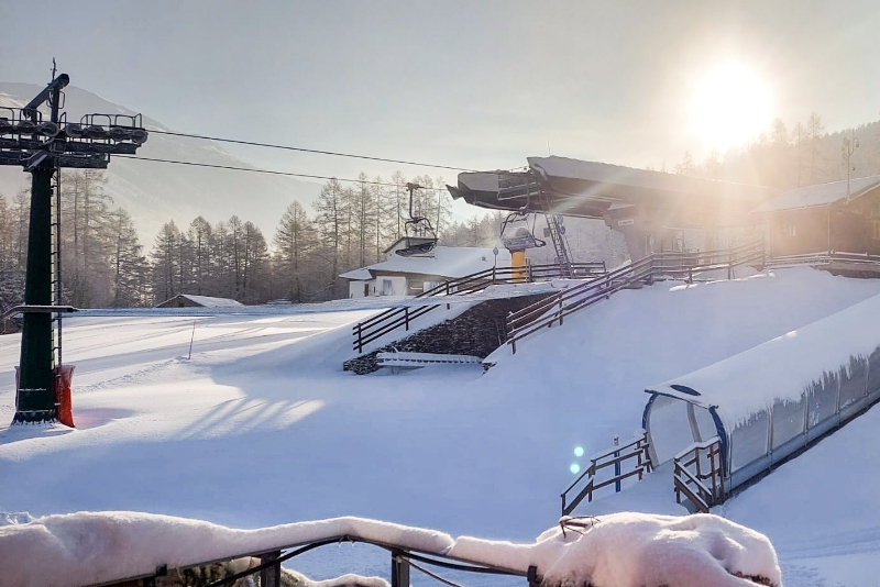
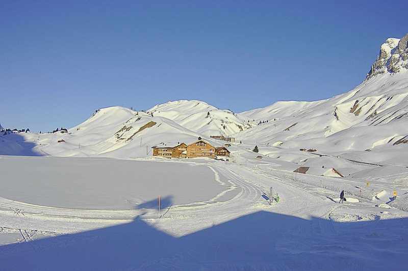
 Still sunny in the Austrian Vorarlberg today but it will turn more unsettled as the week goes on. This is Mellau – 28 March 2022 – Photo: mellau.at
On Tuesday it will remain mostly sunny in the eastern Alps, while skies become a little cloudier further west, with the chance of the odd shower or flurry (1600-2000m) later in the day.
For the rest of the week the weather situation in the Alps will become quite complicated with the formation and deepening of a storm over the southern Alps. The exact position of this storm will determine who gets the most snow, though it does look like many parts of the Alps will see significant snow later in the week.
Any precipitation will still be quite scattered on Wednesday and Thursday but by Friday it will become heavier and more widespread. It will also become colder with snow falling to increasingly low levels.
Updated: 1pm Friday 25 March 2022 – Staying mostly sunny in the Alps…
High pressure continues to dominate the weather in the Alps, meaning plenty more sun today and for several days to come. Freezing levels will be typically around 2200-2800m this weekend, with cold clear nights and pleasant, though not excessively warm, days.
 Plenty of good piste skiing is still possible in the Ski Welt in Austria – 25 March 2022 – Photo: facebook.com/skiwelt
As for snow conditions, there is a textbook freeze-thaw cycle going on, typical for this time of year. Solid overnight refreezes mean that the snow is generally rock hard early on, quickly softening up on east-facing slopes, followed by those facing south then west as the day progresses. This process obviously happens more quickly lower down. Note that, as it is not excessively warm, north-facing slopes above about 2300m are still staying firm all day long.
The fine weather will continue for a few days yet, but there are signs that a cold and potentially snowy spell of weather may arrive from the north later next week. Something to keep an eye on!
Updated: 9am Tuesday 22 March 2022 – Sun, sun, sun!
It’s wall-to-wall sunshine in the Alps today, with freezing levels close to 2000m this afternoon in most regions. The rest of the week will continue to be mostly sunny and will turn a little warmer too, but not excessively.
 Typical spring snow conditions in the Alps this week. This is Pizol in the Glarus Alps of eastern Switzerland – 22 March 2022 – Photo: pizol.com
Snow conditions in the Alps will be typically spring-like over the next few days, with solid overnight refreezes meaning rock-hard pistes early on, softening during the day, firstly on east or south-east facing slopes, then on those facing south, south-west then finally west during the afternoon.
So, some slush should be expected in the afternoons, especially on lower south and west-facing slopes. However, with the ambient temperature being relatively cool for late March, especially today, this won’t be as big an issue as it can be at this time of year. High north-facing slopes won’t have any problem remaining firm and grippy all day long.
As for snow depths, they are below average across the board, and seriously below average (as they have been all season) in the southern Alps where it now looks more like mid-late April then late March.
Updated: 10.30am Monday 21 March 2022 – Spring snow conditions in the Alps…
High pressure is currently in charge of the weather in the Alps, meaning plenty of sunshine for all areas both today and for the rest of the week. It will be relatively cool for late March though, with freezing levels around or below 2000m today, rising a little as the week goes on.
 Spring is in the air in Zell-am-See – 21 March 2022 – Photo: foto-webcam.eu
Snow conditions in the Alps are better than they were last week, when lots of sand in the atmosphere led to often murky (or, at best, hazy) weather, with snow quality severely impacted by the lack of a decent overnight refreeze, especially lower down.
This week we will see a more typical ‘spring snow’ situation, with solid overnight refreezes followed thawing during the day. Lower south-east- facing slopes will be the first to soften, followed by those facing south, south-west and, eventually, west.
However, thanks to the ambient temperature not being especially warm, the slush factor won’t be nearly as bad as it can be at this time of year, and the snow should stay firm and grippy on north-facing slopes above about 2000-2300m for most of the day.
Updated: 7.30am Friday 18 March 2022 - Hazy in the Alps!
Saharan dust is continuing to cause a lot of problems for skiers in the Alps. Although most of the Alps will be dry today, there is a lot of haze/mist/murk around, with the best of any hazy sunshine in the eastern Austrian Alps. Later in the day, the western Alps may see the odd shower (snow 1800-2000m).
 A typical scene in the Alps today, with lots of mist and an orange sandy hue! This is La Condamine-Châtelard in the southern French Alps – 18 March 2022 – Photo: foto-webcam.eu
Snow conditions are very challenging in the Alps right now, not only due to the lack of any widespread or significant snow for many weeks, but also because the Saharan dust storm has significantly affected the quality of the snow.
Any overnight refreeze has been very limited at lower altitudes (due to all the mist and murk), and the snow consistency has been turning to “glue” by day. Some reasonable skiing can be found on higher north-facing slopes, but there is no off-piste to speak of and the overall picture is not a good one right now.
We will bring you more details in our full snow report later today…
Updated: 10am Wednesday 16 March 2022 - Saharan sand!
The Alps are under the influence of a southerly airflow that is carrying a lot of Saharan sand/dust in the atmosphere above western Europe, including the Alps.
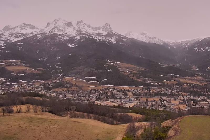
 Rather hazy over Bardonecchia today due to the Saharan dust in the atmosphere – 16 March 2022 – Photo: bardonecchia.it
The weather in the Alps will be mostly fine today if rather hazy at times (thanks to the Saharan dust) aside for a few showers (snow 1800m) in the northern and eastern Austrian Alps (e.g. Kaprun). It will be quite warm across most of the Alps, with freezing levels as high as 3300m, but noticeably cooler in the far eastern Alps (e.g. Obertauern).
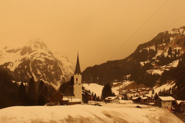 Surreal scenes yesterday in the Alps as Saharan sand turned the sky and snow orange in places, like Schröcken in the Austrian Vorarlberg – Photo: foto-webcam.eu, 15 March 2022
Snow conditions have been very mediocre across much of the Alps in the last day or two, especially lower down where the snow has often been sticky. Snow quality is better higher up and on north-facing slopes, though the Saharan dust in the atmosphere will unhelpfully partially negate any overnight refreeze and will accelerate snowmelt during the day.
Updated: 11am Monday 14 March 2022 - Mostly fine today with fresh snow on the ground in the south-western Alps!
It’s a mostly sunny day in the Alps today, though with some patches of high cloud around, especially in the west. Freezing levels this afternoon will be close to or a little above 2000m.
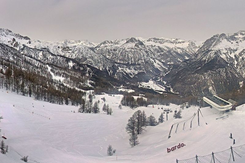
 New snow in the south-western Alps- a bit of a rarity this season! This is Bardonecchia – 14 March 2022 – Photo: bardonecchia.it
Some fresh snow fell over the weekend (mostly yesterday) across some western and especially south-western parts of the Alps, with about 5cm in the Portes du Soleil and at least 10cm in the likes of Isola 2000 and Bardonecchia, where snow has been very hard to come by this season. This new snow will melt soon, but at least in the very short term (i.e. today) these long suffering south-western parts of the Alps can at last enjoy some excellent on-piste conditions.
Yesterday’s snow didn’t spread very far east, just scraping into western Switzerland, with the majority of the Alps missing out.
A new weather front is set to reach the western Alps tonight, bringing a dusting of snow (1200-1500m) in places in the French Alps, the western and southern Swiss Alps, and the central and western Italian Alps, though it will not really amount to much. By mid-week most places should be dry, fairly sunny and increasingly warm.
Updated: 11am Friday 11 March 2022 - A southerly airflow is dominating the Alps…
The Alps are currently under the influence of a southerly airflow that will remain in place for several days. Fundamentally, it is not an especially warm “southerly” (the source of the air is still a relatively cool continent) but the Foehn affect will raise temperatures across the northern half of the Alps, with the coolest weather (counterintuitively) in the south and south-east.
 Dry but rather cloudy at times in the Portes du Soleil today. This is Châtel – 11 March 2022 – Photo: chatel.com
Most places will be dry today but there is a lot of cloud in the south-western Alps (e.g. Montgenèvre, Sestriere, Isola 2000), where a few light flurries are possible, especially tonight. The further north and east you are, the better the chances of seeing sunshine today, with similar weather expected this weekend.
Snow conditions in the Alps are very variable right now. Thanks to the cold temperatures earlier in the week, snow melt has been very limited in the last few days. However, this cold weather, a lack of fresh snow and heavy skiing traffic has led to some rather hard and icy pistes in places, especially lower down. The best conditions have been at altitude on north-facing slopes.
As for snow depths, they remain very modest across the southern Alps (e.g. Montgenèvre, Sestriere, Courmayeur, Cervinia, Livigno, Dolomites). They are also generally below average, but not seriously so, in the northern Alps (e.g. 3 Valleys, Jungfrau region, St Anton, Saalbach).
Updated: 9.30am Thursday 10 March 2022 - Subtle changes to the weather in the Alps…
The huge area of high pressure that has brought mostly sunny but cold conditions to the Alps for the last couple of weeks or so is now starting to slip away eastwards. At the same time, milder air is moving in from the west, but only slowly.
 Another sunny day in the Austrian Vorarlberg. This is Mellau – 10 March 2022 – Photo: mellau.at
Over the next few days, it will continue to turn milder in the western Alps and, due to the Foehn, also in the northern Alps. It will remain cooler further south and east, however. On Friday and Saturday, some snow is also expected to fall in the Italian Piedmont (e.g. Limone, Sauze d’Oulx, Bardonecchia), albeit not amounting to very much, and for most of the Alps it will remain dry, but rather windy with variable cloud cover. The best of the sunshine will be across the northern and eastern Alps.
Snow conditions in the Alps are very variable right now. Thanks to the cold weather, snow melt has been very limited in the last few days. However, this cold weather, a lack of fresh snow and heavy skiing traffic has led to some rather hard and icy pistes in places, especially lower down. The best conditions have been at altitude on north-facing slopes.
As for snow depths, they remain very modest across the southern Alps (e.g. Montgenèvre, Sestriere, Courmayeur, Cervinia, Livigno, Dolomites). They are also generally below average, but not seriously so, in the northern Alps (e.g. 3 Valleys, Jungfrau region, St Anton, Saalbach).
Updated: 9.50am Tuesday 8 March 2022 – Mostly sunny, gradually turning warmer…
It’s another glorious day in the Alps with just a few areas of high cloud drifting around, mostly later in the day. Temperatures will remain on the fresh side with freezing levels typically between 1200m and 1800m east to west.
 Another glorious (but cold) day in the Austrian Alps. This is the Mölltal glacier – 8 March 2022 – Photo: facebook.com/moelltaler.gletscher
It will remain fine across most of the Alps over the next few days, though weather fronts will try to approach the western Alps later in the week, possibly bringing some snow to the southern French and south-western Italian Alps (e.g. Isola 2000, Sestriere) on Friday. It will also turn milder, especially in the western Alps.
The last few days have been mostly sunny but quite cold across the Alps, which has offered some enjoyable skiing, so long as you’re happy sticking to the pistes. That said, the lack of fresh snow and high volume of skiers has led some runs to become quite icy, especially in the southern Alps where snow cover remains thin.
On the flip side there has also been less slush than you would normally expect at this time of year, although the increase in temperatures this week does mean that the freeze-thaw cycle will start to become more noticeable again.
Updated: 9am Tuesday 2 March 2022 - Mostly fine weather in the Alps…
It’s another dry day across the Alps, with plenty of sunshine in most areas but with some areas of high cloud drifting around, especially this afternoon. It will remain relatively cool for March with freezing levels typically between 1500m and 2000m.
 Another mostly fine day in the Alps. This is Bettmeralp in the Aletsch Arena – 2 March 2022 – Photo: bettmeralp.ch
Over the next few days, the weather in the Alps will remain mostly dry though there may be some flurries this weekend in the western Italian Alps, especially in the southern Piedmont (e.g. Milky Way). It will also turn colder and remain chilly into the first part of next week.
This mostly fine but quite cool weather is good news for skiers in the Alps as, although the sun is now quite strong, any thaw will only be gradual. That said, snow cover is very thin across some of the southern Alps, notably in the southern French Alps (e.g. Auron, Risoul) and south-western Italian Alps (e.g. Sauze d’Oulx, Bardonecchia), where it looks more like mid-April than early March.
The situation is better elsewhere though, with generally near normal snow cover across the northern half of the Alps.
Updated: 9am Tuesday 1 March 2022 – Mostly sunny!
Another sunny and relatively cool day is expected across the Alps, with freezing levels typically between 1000m and 2000m.
 Cloudless skies above Warth-Schröcken this morning – 1 March 2022 – Photo: warth-schroecken.at
Most places will remain dry and fine over the next few days, but the odd flurry is possible here and there later in the week, especially in the southern and eastern Alps. It will turn colder on Friday and remain quite cold throughout the weekend and into next week.
This mostly fine but quite cool weather is good news for skiers in the Alps as, although the sun is now quite strong, any thaw will only be gradual.
That said, snow cover is very thin across some of the southern Alps, notably in the southern French Alps (e.g. Auron, Risoul) and south-western Italian Alps (e.g. Sauze d’Oulx, Bardonecchia), where it looks more like mid-April than late February.
The situation is better elsewhere though, with generally near normal snow cover across the northern half of the Alps.