


Updated: Thursday 29 March 2018 - Very unsettled, relatively mild…
The weather in the Alps remains very unsettled, with further snow (and some rain) for many over the next two to three days.
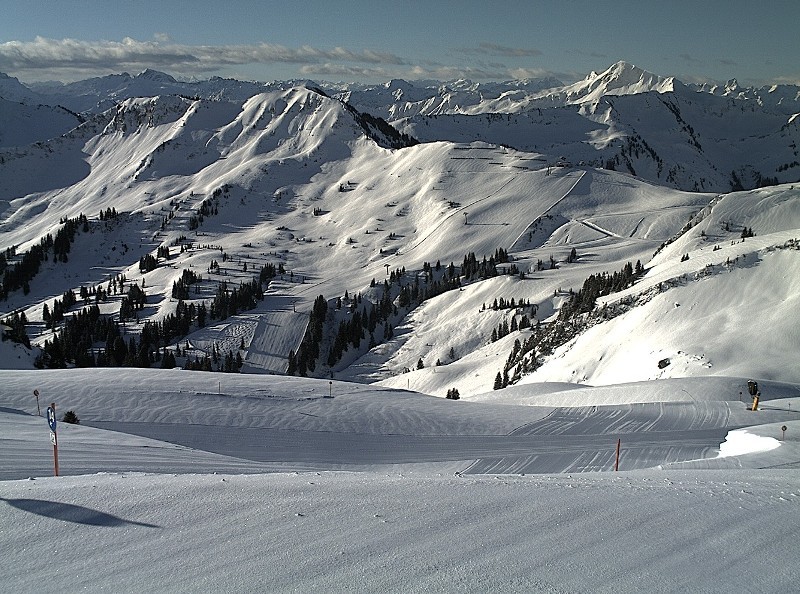
 A break in the weather this morning in Méribel, but there will be more snow (and some rain) over the next couple of days – 29 March 2018 – Photo: merinet.com
Any showers in the western Alps (snow 900-1300m) today will quickly die away, but they will continue on and off all day further east (i.e. eastern Switzerland, Austria and the eastern half of the Italian Alps) where the rain/snow limit will sit between 800m and 1500m.
It will remain changeable on Friday with further showers or longer spells of rain/snow for many, especially later in the day and in the southern and western Alps. The rain/snow limit will again start quite high (1500-2000m) before dropping in the west later.
Saturday will again be unsettled with further showers just about anywhere and a rain/snow limit between 1000m and 1800m (lowest in the north-west).
Snow depths across the Alps remain impressive for late March, and are exceptional even at altitude where base depths of between 3m and 5m are still common. Snow quality is more variable, however - not surprising given the highly changeable weather and wildly fluctuating temperatures.
If you are skiing anywhere high this weekend then you have a good chance of finding some significant fresh snow, but expect some wetter conditions at times lower down.
Updated: 9.50am Wednesday 28 March 2018 - Still very unsettled but milder…
The weather in the Alps remains very unsettled with a succession of storms moving in from the Atlantic over the next few days.
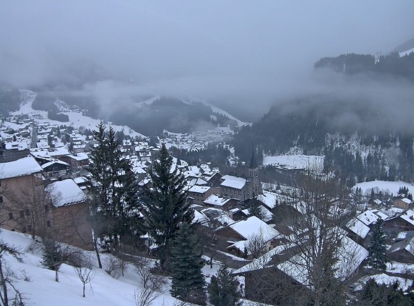
 Bright start in Val d’Isère this morning, but snow (and possibly some rain at resort level) will return later today – 28 March 2018 – Photo: valdisere.com
This morning we have a scattering of showers, mostly across the northern half of the Alps, with a rain/snow limit between 1000m and 1500m. However, a band of more persistent precipitation is already knocking on the door of the northern French Alps and will spread into Switzerland as the day progresses, eventually reaching western Austria later in the day.
The rain/snow limit will rise to as high as 2000m for a time in the northern French and western Swiss Alps, but will broadly remain a bit lower further east, before it falls more generally again overnight.
Meanwhile, except for a few showers here and there, many southern parts of the Alps will stay dry with the best of any sunshine in the far south-western Alps, close to the Mediterranean.
On Thursday, any early showers in the western Alps will clear away eastwards to leave some sunny spells. The eastern half of the Alps will remain rather cloudy with further showers (snow 900-1500m). The central southern and south-eastern Alps (e.g. Lombardy, Dolomites) will also see more showers than today, with a little snow above 1400-1700m.
Snow cover remains very impressive for late March but snow quality is much more variable due to the constantly changing weather and fluctuating temperatures. There will be plenty of powder around at high altitude over the next few days but also some spring-like conditions at times lower down.
Updated: 10.40am Tuesday 27 March 2018 - Remaining very changeable
The weather in the Alps remains unsettled with further snow, but also some rain, in places over the next few days.
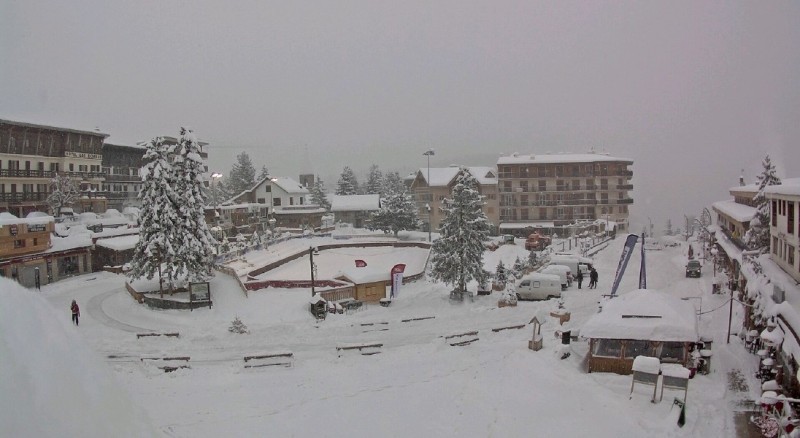
 Changeable looking weather in Turracher Höhe on the Carinthia/Styria border in Austria today – 27 March 2018 – Photo: turracherhoehe.at
This morning we have some showers across parts of Austria and eastern Switzerland (snow around 1000m) which will gradually clear away eastwards as the day progresses leaving a few centimetres here and there.
More importantly, however, we have a warm front approaching the western Alps which will bring some more significant precipitation to the French and western Swiss Alps later today, moving further east tonight. The rain/snow limit will start around 1000-1200m but will rise to 1800m in some exposed western parts of the Alps tonight.
Tomorrow will remain very unsettled with further rain or snow, mostly across the northern and western Alps. The rain/snow limit will start quite high (typically between 1500m and 2000m) before dropping again later. In the north-western Alps, especially the northern French Alps (e.g. Avoriaz, Flaine, Chamonix), 30-50cm is possible above 2000m by the end of Wednesday.
Later in the week, the heaviest precipitation will temporarily transfer to the southern Alps.
Snow cover remains very impressive across the Alps for late March. However, snow quality will be highly variable over the next few days thanks to the fluctuating temperatures and mixture of rain and snow.
Updated: 10.15am Monday 26 March 2018 - Changeable week
It will be an unsettled week in the Alps with fluctuating temperatures and some rain/snow at times, heaviest in the north-west.
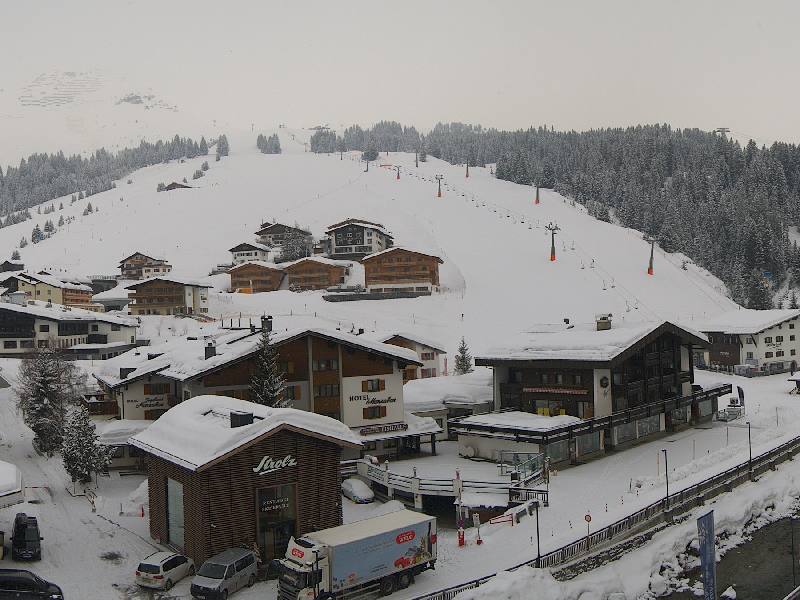
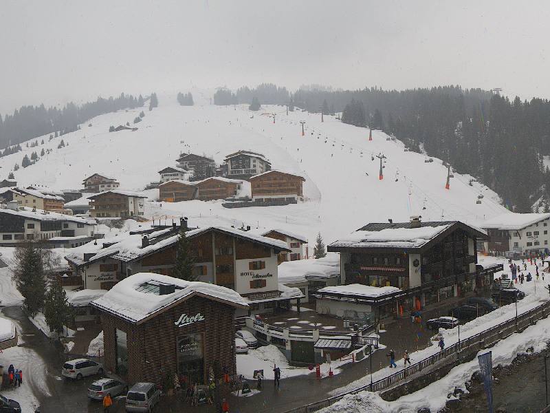 Mostly cloudy with showers today in Lech – 26 March 2018 – Photo: lech.com
Many places will start dry today though showers will develop across the northern Alps, heaviest latest in the day with snow above 1000-1400m. Snowfall totals will be modest but a few centimetres are possible above about 1500m in resorts such as Flaine, Mürren, Engelberg and St Anton.
On Tuesday and Wednesday some more active weather fronts will affect the Alps, with the heaviest precipitation again in the north-west. However, with some milder air in the mix, the rain/snow limit will reach 1400-1800m for a time (possibly even 2000m in some exposed north-western resorts) before lowering again later on Wednesday. 30-50cm of snow is possible above 1800m in some north-western resorts by Thursday morning. Later in the week, the heaviest snow will then transfer to the southern Alps.
Snow cover across the Alps remains excellent for late March with exceptional base depths at altitude. Snow quality will be more variable this week due to the changeable weather and yo-yoing temperatures but there will still generally be plenty of good skiing on offer, especially at altitude.
Updated: 11am Friday 23 March 2018 - Great snow conditions continue in the Alps
A weak weather front has brought a little snow to the northern Alps overnight, with no more than a dusting in the northern French Alps, in resorts like Avoriaz, but 5-15cm in the northern Swiss and Austrian Alps (e.g. Lech).
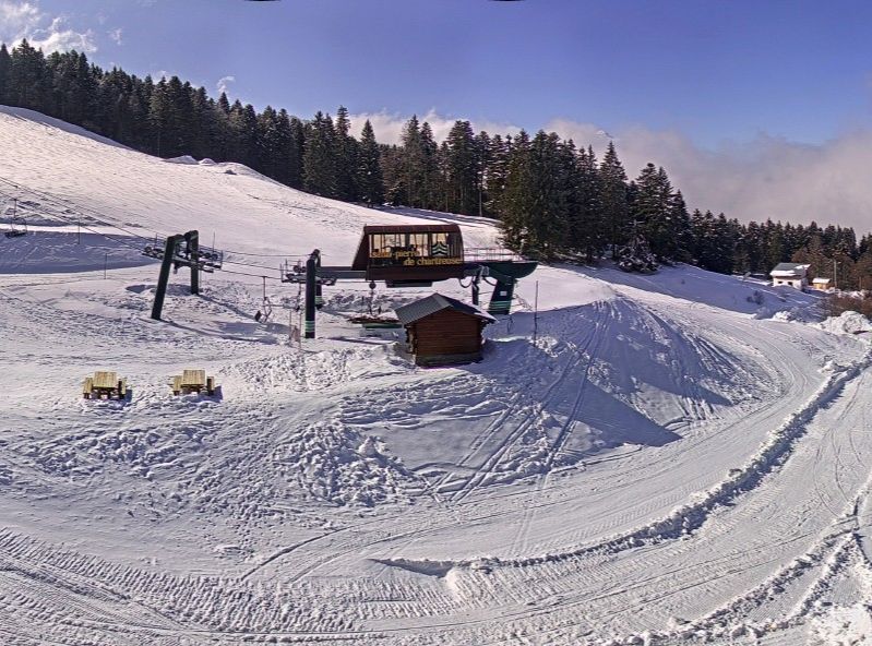 Fabulous snow conditions for late March, even at low altitudes. This is St Pierre de Chartreuse – 23 March 2018 – Photo: ski-alpin-chartreuse.com
Today the flurries (600-800m) across Austria will clear away, though it may take some time for any cloud to break up across the central and eastern Austrian Alps. We can expect plenty of sunshine elsewhere but still relatively low freezing levels of between 1000m and 1600m.
A few flurries are possible tomorrow in the south-western Alps (notably the southern Piedmont) but most places will be dry with the best of any sunshine the further north and east you are. Next week looks unsettled with the chance of further snow for some.
Snow conditions remain excellent for late March with deep bases at altitude (and lower down in some places), and below average temperatures ensuring that the freeze-thaw process is relatively limited.
Updated: 12.30pm Thursday 22 March 2018 - Still relatively cold, further bits and pieces of snow here and there
The weather in the Alps will remain changeable over the next few days, with a little snow falling here and there, but not generally in any great quantity.
 Looking good in Verbier this morning – 22 March 2018 – Photo: mountainbeds.com
After what has been a very cold week so far, temperatures are slowly rising again but will remain below average for late March. Indeed, it may well turn cold again next week.
Thursday will be dry for most but cloud will increase in the north – especially in the northern Swiss and Austrian Alps with some snow (to low altitude) later in the day and overnight. Tomorrow, the last of any snow will clear the north-eastern Alps (i.e. Austria), leaving many areas with a relatively fine day.
Saturday will then see a little snow across the south-western Alps, especially in the southern Piedmont, otherwise most regions will remain dry. Later on Sunday and into the start of next week, the focus of the precipitation be on the northern Alps, especially the north-western Alps where some significant snow is likely on Tuesday.
Snow conditions in the Alps remain impressive for late March with exceptional snow depths at altitude in many regions. The recent cold weather has also limited the freeze-thaw cycle which is normally prevalent at this time of year, which is only really affecting low areas to any degree right now. With further cold and potentially snowy weather likely next week, anyone heading out to the Alps over Easter could be in for a real treat.
Updated: 9.45am Wednesday 21 March 2018 - Still cold!
The weather in the Alps remains unusually cold for late March. The best of any sunshine will be at altitude and in the southern Alps today, while the cloudiest conditions will be lower down and in the northern Alps. Most places will be dry but don’t be surprised to see a few light snow flurries here and there.
 Cold but bright in the southern Austrian Alps this morning. This is Lienz – 21 March 2018 – Photo: foto-webcam.eu
It will gradually turn milder over the next few days, but it will be a slow process. Cloud coverage will be variable and there will still be the odd flurry around, but most places will see some sunshine.
Snow conditions in the Alps are impressive for late March. While there are some hard and icy patches at low altitudes, in most cases the pistes remain in great shape. Snow quality is naturally more variable off-piste but you can still find some powder (with a good guide), especially in the southern and western Alps.
Note that the current cold spell means that the freeze-thaw cycle is much more limited than it would normally be at this time of year.
Updated: 9am Tuesday 20 March 2018 - Cold!
The Alps are under the influence of a cold easterly airflow, with quite a lot of low cloud around generally, and even a few light flurries here and there. There is also some sunshine though, the best of this being at altitude and/or in the southern Alps.
 Cold and cloudy at low altitude in the Vorarlberg today. This is Lech – 20 March 2018 – Photo: lech.com
Snow cover remains very healthy across most of the Alps for late March even if snow quality is more variable. Given the cold, the transition from ice to slush is less marked at low altitude than it might otherwise be at this time of year, and there are generally quite decent on-piste conditions in most places. That said, watch out for icy patches, especially on lower runs.
You can still find some powder around off-piste, especially in the southern and western Alps where the heaviest snow has fallen in recent days. Always take a guide, unless you know exactly what you are doing.
The rest of the week will remain unusually cold across the Alps, though there won’t be a great deal of snow – just a few flurries here and there. Towards the end of the week it will start to warm up a little but the process will be a slow one.
Updated: 10.15am Friday 16 March 2018 - Excellent snow conditions across most of the Alps
There are still a few showers across the eastern Alps this morning (snow 1200-1500m) but they will move away as the day progresses. Elsewhere in the Alps some good sunny breaks are developing, but these will set off a scattering of showers later in the day, especially in the west, with a little snow above 1100m.
 Lots of fresh snow across the central Italian Alps. This is Livigno – 16 March 2018 – Photo: livigno.it
Snow conditions are generally very good, especially in the southern and western Alps where there was significant fresh snow yesterday (e.g. Risoul, Isola 2000, Sestriere, Monte Rosa, Livigno, Passo Tonale). The north-eastern Alps (i.e. Austria) have seen the least snow in recent days but have still got some perfectly decent piste skiing on offer.
Over the weekend it will turn colder from the east. There will also be further snow which will fall to increasingly low levels.
Updated: 8.40am Thursday 15 March 2018 - Unsettled again with the heaviest snow in the southern Alps
After a mostly glorious day in the Alps yesterday, the bad weather is back, especially in the southern and western Alps.
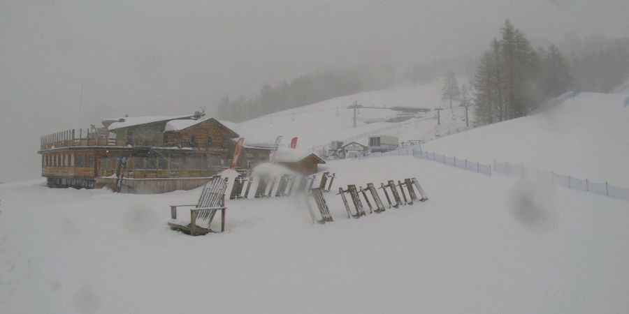 Heavy snow this morning in Bardonecchia – 15 March 2018 – Photo: bardonecchiaski.com
Early this morning it is already raining or snowing extensively across the western Italian Alps (e.g. Milky Way), the southern French Alps (e.g. Risoul, Isola 20000) and the western foothills of the northern French Alps.
As the day progresses the bad weather will move slowly eastwards across the rest of the northern French Alps and the Swiss Alps. However, it is in the southern Alps where it will remain heaviest, with 50cm or more possible at altitude. The rain/snow limit will be highly variable, starting at around 1800m in the west, then lowering to 1200m or so later in the day. In the southern Alps it will generally be lower, particularly in the western Italian Alps where it is already below 1000m in places this morning.
Protected by the Foehn, the north-eastern Alps (i.e. Austria) will be drier today, if rather cloudy at times, with just a few showers in the south and west later.
Friday will see an improvement of sorts in the west but will be still be rather changeable everywhere with some sunny spells but also a few showers here and there.
Updated: 11.20am Wednesday 14 March 2018 - Glorious for most of the Alps
There is still some cloud across the eastern Alps this morning but this should break up as the day progresses. For most other areas it is a glorious day with plenty of sunshine and relatively mild temperatures (with freezing levels close to or above 2000m).
 A glorious day for most of the Alps. This is Les Saisies – 14 March 2018 – Photo: lessaisies.com
A new set of weather fronts will approach from the west tomorrow, the heaviest snow this time due in the southern Alps, especially in areas close to the Italian borders with France and Switzerland. It will then turn colder from the east over the weekend, with further snow in places and to increasingly low levels.
Updated: 11am Tuesday 13 March 2018 - Further flurries for the north-western Alps today
There are further snow showers (1000-1200m) today across the north-western Alps – i.e. the northern French Alps, much of Switzerland away from the far south and some western parts of Austria. They won’t amount to a huge amount, but will deposit a few centimetres here and there, perhaps 20cm+ in one or two favoured locations.
 New snow in the north-western Alps. This is Méribel – 13 March 2018 – Photo: merinet.com
This follows quite a snowy 24 hours across the north-west, especially the northern French Alps, where 30cm of new snow has fallen in places, such as Flaine. In general, the southern Alps have seen fewer showers/flurries over the last day or two.
On Thursday a new set of active weather fronts will approach from the west with the heaviest snow transferring back to the southern Alps. More details in our snow forecast later today…
Updated: 11.45am Monday 12 March 2018 - Snow for the north-west after a snowy weekend in the south
The Alps are currently under the influence of an unstable north-westerly airflow, and will see showers (snow 1000-1500m) today, heavy at times across the northern French (e.g. Flaine, Avoriaz) northern and western Swiss Alps (e.g. Mürren, Engelberg) where 10-30cm is possible above 1500m.
 50cm of new snow over the weekend in Serre Chevalier – 12 March 2018 – Photo: facebook.com/SerreChevalier
There will also be some showers moving into Austria but with a slightly higher rain/snow limit. Although the southern Alps will be rather cloudy, they will generally see fewer showers.
Over the weekend, the southern Alps saw copious amounts of snow. This initially favoured the southern French Alps (e.g. Serre Chevalier, Isola 2000) and the southern Piedmont (e.g. Sestriere, Prato Nevoso), followed by Lombardy (e.g. Livigno), parts of the Engadin (e.g. St Moritz) and the western Dolomites (e.g. Madonna di Campiglio). Some of these areas saw in excess of 50cm of new snow.
Meanwhile, the Foehn was blowing further north, which therefore saw warmer and (initially at least) drier weather, though there were a few showers here and there, and some more organised precipitation (snow above 1600-2000) moved in from the west later on Sunday.
Snow conditions today are therefore quite mixed, with lots of powder in the south and, also increasingly in the north-west. By contrast, conditions are still quite spring-like in the east (e.g. Salzburgland).
There will then be further snow across the north-western Alps on Tuesday before the pattern shifts again later in the week, with heavy snow set to return to the south! Next weekend may also turn much colder again as Siberian air is forecast to move in from the east. Watch this space!
Updated: 10am Friday 9 March 2018 - Warming up!
Temperatures in the Alps are on the rise, with freezing levels expected to reach between 2000m and 2600m today (east to west). There is also more in the way of cloud around than we saw yesterday, though it should stay mostly dry and there will still be some sunny spells.
 Mostly dry but more in the way of cloud around today in the Alps. This is the Tux valley in Austria – 9 March 2018 – Photo: foto-webcam.eu
There is the risk of some rain across the western Alps tomorrow, falling as high as 2200m in the French and western Swiss Alps. The rain/snow limit will be a bit lower in the southern French Alps, where the heaviest precipitation is expected - around 15-40cm above 2200m.
It will remain changeable on Sunday with further showers in places, heaviest and most frequent across the southern Alps. Throughout this period the north-eastern Alps (e.g. Salzburgland) will see the least precipitation but, it will be exceptionally mild in the northern Alps due to the Foehn, with 20°C forecast in Salzburg itself on Sunday.
Snow conditions in the Alps will become much more variable over the next few days with some fresh snow at high altitude, especially in the south and west, but with wet or spring-snow conditions lower down.
Updated: 9am Thursday 8 March 2018 - Glorious snow conditions in the Alps today
It’s a lovely morning across most of the Alps and should remain fine for most of the day, with just a few areas of cloud here and there, especially later in the day in the west. Freezing levels this afternoon will sit somewhere between 1500m and 2000m.
 Glorious skiing conditions today in the Austrian Vorarlberg following 15cm of new snow. This is Mellau – 8 March 2018 – Photo: mellau.at
With fresh snow falling across a wide swathe of the Alps yesterday snow conditions are generally excellent. The heaviest snow fell across the northern half of the Alps with 15cm in both Flaine and Lech, for example. However, many southern parts of the Alps also saw at least little fresh snow with 5cm across much of the Dolomites.
Over the next few days it will turn noticeably milder as the southerly flow strengthens. After a mostly dry day on Friday, the southern and western Alps will see showers on Saturday and Sunday. These will move slowly east as the weekend progresses, with the rain/snow level rising to 2000m or higher.
Updated: 8.20am Wednesday 7 March 2018 - Still mixed
It’s another day of highly variable weather across the Alps, with some sunny spells but also bands of showers moving slowly east.
 Fresh snow in the northern French Alps today. This is Les Saisies – Photo: lessaisies.com
Almost anywhere could see a little snow over the next 24 hours but it will be the north-western Alps that will catch the most - i.e. the northern French Alps (e.g. Flaine, Avoriaz), much of Switzerland away from the far south, and the far west of Austria (e.g. Lech). These regions could see between 10cm and 30cm by the end of tonight.
The southern Alps will see fewer showers with the greatest concentration likely to be in Lombardy and the western Dolomites (e.g. Madonna di Campiglio). The rain/snow limit today will be close to 1000m but will tend to lower in the north-west later.
Over the next few days it will start to turn milder again. Thursday and Friday will be mostly dry but it will turn unsettled over the weekend with a mixture of rain and snow, most prevalent in the south and west.
Updated: 10.40am Tuesday 6 March 2018 - Changeable!
The weather in the Alps is in quite a changeable mood this week. We will see occasional showers today, mostly across the northern half of the Alps with snow above 900-1200m (east to west). The southern Alps will see the fewest showers and the best of any brighter spells.
 Snow showers in the Portes du Soleil today above about 1200m, with rain below. This is Châtel (1200m) – 6 March 2018 – Photo: chatel.com
Snowfall totals today will generally be quite modest, with just a few centimetres here and there and a maximum of 10-15cm in some parts of the northern French Alps (e.g. Flaine, Avoriaz).
On Wednesday, showers will become a little more widespread across the Alps but still heaviest in the north and west where another 10-30cm is possible. It will be temporarily colder with the rain/snow limit falling below 1000m in most areas. Later in the week it will turn milder with rain showers to higher levels.
Snow conditions in the Alps remain very good for March even if sunshine is hard to find right now. Take particular care off-piste, however, as the snow is unstable and there have been numerous incidents (including a number of fatalities) in recent days.
Updated: 10am Monday 5 March 2018 - Variable cloud cover with a few flurries, mostly in the south
The weather in the Alps is quite variable today with areas of cloud around, especially in the south, but also plenty of sunshine, the best of this at altitude in the north.
 Great snow cover in the south-western Alps thanks to the recent storms. This is Sestriere – 5 March 2018 – Photo: vialattea.it
Most places will be dry but there will be a few flurries here and there, notably in the southern French Alps (e.g. Isola 2000), the southern Piedmont (e.g. Prato Nevoso) and the far south-eastern Alps (e.g. Nassfeld).
The rest of the week will remain rather changeable with a little snow here and there – perhaps some heavier and more widespread snow mid-week – but also plenty of dry weather. Temperatures will be close to what you might expect for early March. However, thanks to an increasing Foehn wind, it will turn milder in the north later.
Snow conditions in the Alps remain good in most areas, especially in the west where there has been plenty of new snow in recent days. The southern French Alps (e.g. Isola 2000, Les Orres) have done particularly well over the last week or so.
Updated: 9.30am Thursday 1 March 2018 - Fresh snow for many southern and western areas
There is fresh snow across some parts of the Alps this morning, mostly in France, Switzerland and western Italy. If it’s powder you are after, then the most significant fresh snow is in the southern French Alps (e.g. Isola 2000, Auron, Les Orres, Risoul, Serre Chevalier).
 Lots of new snow in the southern French Alps today. This is Auron – 1 March 2018 – Photo: winter.auron.com
Elsewhere in the Alps there are bits and pieces of new snow here and there, but many eastern areas (i.e. Austria) are dry, if still rather cloudy. Another noticeable feature of the weather in the Alps is the increase in temperature. Although it is hardly warm, we have lost the extreme temperatures that were affecting all Alpine regions earlier in the week.
Snow conditions in the Alps remain very good with generally above average snow depths for early March, especially at altitude. For further details please check out our latest snow report.