


Updated: 11.20am Thursday 30 January 2020 - Remaining unsettled but turning warmer…
Over the last couple of days, a lot of snow has fallen across the northern and western Alps. The weather in the Alps is now set to remain unsettled over the next few days but, thanks to milder air in the mix, rain will become a nuisance in places, particularly across the northern Alps.
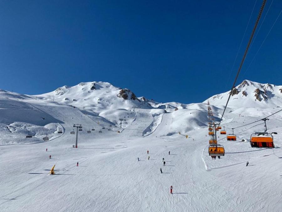
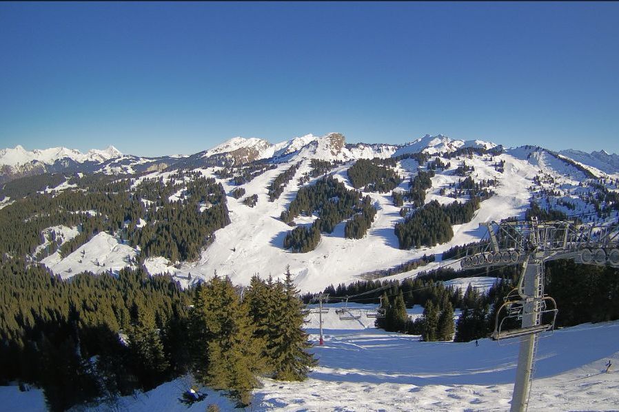
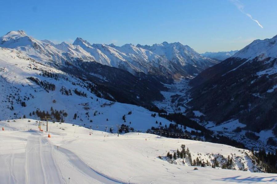 Perfect snow and perfect weather in St Anton this morning - but make the most of it! The weather will turn much milder over the next few days with some rain lower down – 30 January 2020 – Photo: stantonamarlberg.at
Today got off to a bright start in many places, although cloud is already thickening across the western Alps with some rain or snow expected later in the French Alps (especially in the north) and western Swiss Alps. The rain/snow limit will start between 1400m and 1800m but will rise to 2000m or so overnight.
On Friday, early showers (snow 1800-2000m) will clear the Austrian Alps leaving most areas with a bright but very mild day. A new warm front will then move in from the west on Saturday, bringing rain/snow to the French and western Swiss Alps, before it heads further east on Saturday night. The rain/snow limit will be between 2000 and 2300m. The southern Alps will stay mostly dry.
Not surprisingly, snow conditions will deteriorate at low and medium altitudes over the next few days, especially in the northern and north-western Alps which will see the heaviest of any rain.
Winter will return by the middle of next week though, with a blast of cold and potentially snowy air expected to move down from the Arctic. Watch this space….
Updated: 9.30am Wednesday 29 January 2020 - Big snowfalls across many western and northern parts of the Alps…
There is a lot of fresh snow this morning across the northern and western Alps. Given the amount of wind, it is quite difficult to know exactly how much as fallen but the general consensus is that the northern French Alps (e.g. Espace Killy, Paradiski, 3 Valleys, Grand Massif, Portes du Soleil) have already seen between 40cm and 70cm of new snow above 1800m, with more to come today.
 Huge snowfalls in Val Thorens – 29 January 2020 – Photo: facebook.com/ValThorens.resort
Much of the Swiss Alps have also seen significant snow, especially the north and west (e.g. Morgins, Verbier, Mürren), with typically between 30 and 60cm at altitude. Similar quantities have fallen in parts of western Austria, with 40cm in Lech for example.
The far north-west of Italy (e.g. Courmayeur, La Thuile) has also seen big dumps but, generally, the further south and east you are the less snow has been generated by this storm. The Austrian resorts of Saalbach and Obertauern, for example, have seen closer to 10-15cm, while the Dolomites have 5-10cm.
It is still snowing today across many northern parts of the Alps, roughly above 600-900m, but precipitation is much patchier in the south. The weather will then remain unsettled for the rest of the week, although turning milder, with further precipitation from time to time, mostly across the northern Alps. There also will be some snow, but with a higher rain/snow limit, closer to 2000m or even above that at times.
By the middle of next week, the weather should have turned much colder again with heavy snow forecast for many places, especially in the northern Alps.
Updated: 12pm Tuesday 28 January 2020 - Stormy!
A major Atlantic storm has reached the Alps, with significant snow expected across many northern and western regions over the next day or two.
 Heavy snow in Lech this morning – 28 January 2020 – Photo: lech.com
Some southern and eastern parts of the Alps remain dry today, however many regions will see some showers or longer spells of rain or snow which will continue overnight and into tomorrow. The heaviest precipitation will fall in the north-western Alps, with predicted storm totals of 50-80cm above 1800m by tomorrow in the French Savoies (e.g. Paradiski, 3 Valleys, Grand Massif, Mt Blanc area).
Many northern and western Swiss resorts (e.g. Verbier, Engelberg), some western Austrian resorts (e.g. Lech, St Anton) and the far north-west of Italy (e.g. Courmayeur, La Thuile) will see 30-50cm by the end of tomorrow but, on the whole, the further south and east you are the less snow there will be. The central/eastern Austrian Alps (e.g Obertauern, Hintertux) will see 10-20cm of new snow, while the rest of the Italian Alps (i.e. away from the north-west) will generally only either a dusting or up to 15cm.
This storm’s rain/snow limit started at around 1500-1700m yesterday evening but has now fallen to under 1000m in the western Alps today and will generally level out at between 500m and 900m later today and tomorrow.
After a brief respite in the weather early on Thursday, further but weaker weather fronts will arrive from the west later in the day. It will turn warmer though, with the rain/snow limit rising back up to 1500m or higher.
The weather will then remain mild but rather unsettled over the weekend with further bits and pieces of rain and snow here and there, heaviest in the north and west.
By next Tuesday we are then expecting a major outbreak of cold polar air to bring heavy snow to low altitudes across many parts of the Alps, especially in the north. Watch this space…
Updated: 9.30am Monday 27 January 2020 - Major snowfall for some western parts of the Alps…
The Alps are currently being approached by a major Atlantic storm which is set to deliver significant quantities of snow to many western parts over the next couple of days.
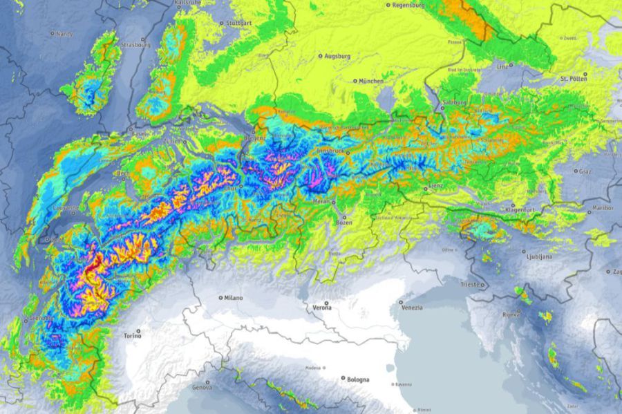 72-hour predicted snowfall totals for the Alps showing the heaviest falls in the northern French Alps – 27 January 2020 – Image: bergfex.com
After a fine start across many parts of the Alps, cloud will increase in the west today with the first precipitation arriving in the French and western Swiss Alps this evening (snow 1500-1700m). The precipitation will intensify tonight and tomorrow across the western Alps, with the rain/snow limit gradually lowering towards or even below 1000m. It will also become very windy with blizzards expected at altitude.
The northern French Alps (roughly north of Grenoble) and the south-western Swiss Alps (e.g. Verbier) are set to see the heaviest snow from this storm, with a forecast 40-60cm above 1800m by Wednesday, and 80cm+ in a few favoured spots in France.
As a rule, the further south and east you are, the less significant any snow will be. That said, there will still be some useful falls across the eastern Swiss Alps, most of the Austrian Alps and some parts of the Italian Alps, especially in the north-west (e.g. La Thuile, Cervinia).
Late on Wednesday there will be a brief respite in the weather, before a new front reaches the Alps on Thursday. This will be a warm front, meaning that the rain/snow limit will rise from relatively low altitudes back up to 1500m or higher.
Updated: 2pm Wednesday 22 January 2020 – A little cloud in the south-west otherwise still mostly sunny…
It’s another lovely day across most of the Alps, though there is a bit more in the way of cloud across some parts of the southern French and south-western Italian Alps (e.g. Isola 2000, Bardonecchia).
 Sunny if slightly hazy skies over Les Saisies today – 22 January 2020 – Photo: lesaisies.com
The clouds come courtesy of the same Mediterranean storm that is currently delivering copious amounts of snow to the eastern Pyrenees. The south-western Alps will eventually also see a few showers/flurries later this week and over the weekend from this storm, although no significant or widespread snow is expected.
Snow conditions in the Alps remain pretty good in most places even if cover is getting bit thin or patchy at very low altitudes. Temperatures have become quite mild again, after an initially cold start to the week, but snow melt will be minimal thanks to the dry air, and all pistes should remain firm and grippy.
Some more widespread precipitation is expected across the northern Alps early next week but, with plenty of warm air still in the mix, there may be some nuisance value rain at lower altitudes. Watch this space…
Updated: 3pm Tuesday 21 January 2020 - Still mostly sunny in the Alps, but milder…
Yesterday was just about the perfect ski day in the Alps with little or no wind, deep blue skies, frigid temperatures and fresh snow still hanging on the trees from the weekend in places.
 Perfect weather and prefect pistes in Ischgl right now – 21 January 2020 – Photo: facebook.com/Ischgl.Paznaun
With high pressure still in control, today has also been pretty good, though one key difference is that temperatures are much milder, especially at altitude. The next couple of days will also remain mostly fine and relatively mild.
More in the way of cloud, and a few showers/flurries, will creep into the south-western Alps towards the end of the week. We are not expecting any significant or widespread snowfall though, and high pressure will reassert itself, bringing lots more fine weather that could last into the first part of February.
Updated: 12pm Monday 20 January 2020 - Cold but mostly sunny in the Alps…
It’s a glorious if rather cold day across most of the Alps, with just a little more in the way of cloud and the odd flurry, in both the eastern Austrian Alps and southern Piedmont (Italy).
 Gloriously sunny in Lech today with fresh snow from the weekend storm still clinging to the trees – 20 January 2020 – Photo: lech.com
With high pressure in control, the weather in the Alps will remain fine for most of this week. Temperatures will also increase but, thanks to low humidity, any snowmelt will be minimal and confined to low south-facing slopes. Towards the end of the week it may turn slightly more unsettled with a little snow in places, but nothing significant is expected at this stage.
Snow conditions in the Alps are generally pretty good right now. Fresh snow fell over the weekend, starting in the western Alps on Friday night before spreading further east on Saturday, with some flurries lingering in the east on into Sunday.
Snowfall totals from the latest storm were generally quite modest, though they did reach 20-35cm in places, chiefly in the northern Alps.
One notable feature of the weekend’s weather was how much colder it turned, with Sunday’s residual snow flurries falling to very low levels before temperatures fell to -20°C or lower in some internal Alpine valleys on Sunday night.
Updated: 10am Saturday 18 January 2020 - Temporary return to winter…
Winter has returned to the Alps, if only temporarily. Many parts of the Alps are waking up to fresh snow this morning, albeit not generally in large quantities. It will continue to snow for a while today across some north-eastern parts of the Alps (mostly in Austria), but the sun is out again in the western Alps.
 Fresh snow and sunny skies in Méribel this morning – 18 January 2020 – Photo: merinet.com
This latest storm has delivered 5-30cm above 1500m in the northern Alps, with the heaviest falls in the north-west, where Avoriaz, Flaine and Mürren have all seen around 25cm at 2000m. Less snow has fallen in the central and southern Alps, with barely anything in places but up to 15cm in some parts of the southern French Alps.
Next week high pressure will become the dominant weather feature again, meaning that there will be lots of sunshine across the Alps, especially at altitude.
Updated: 2pm Friday 17 January 2020 - New snow for the Alps, but not in huge quantities…
It’s snowing again this afternoon across the western Alps (i.e. the French and western Swiss Alps) with a rain/snow limit around 1300-1500m, which will drop to below 1000m tonight.
 Heavy snow this afternoon in Chamrousse near Grenoble – 17 January 2020 – Photo: chamrousse.com
This band of precipitation will move eastwards overnight, reaching the western Austrian Alps in the early hours of Saturday, then the eastern Austrian Alps by daylight tomorrow.
Snowfall totals from this storm will generally be modest, with typically 5-20cm above 1500m across the northern half of the Alps, and somewhere between a dusting and 10cm across the southern Alps (i.e the Italian Alps). Although this represents a bit of downgrade from the forecasts of a day or two ago, it will still be welcome given the lack of snow in recent days, and even weeks in some areas.
High pressure will reassert itself next week, meaning lots of fine and sunny weather again, especially at altitude.
Updated: 10.15am Wednesday 15 January 2020 - Slight upgrade to weekend storm!
After a mostly dry and relatively mild week, we are still on course for some colder and snowier weather at the end of the week and over the weekend. What’s more, this snow may now be a little heavier and more widespread than originally anticipated.
 Another lovely day in the southern Swiss Alps – 15 January 2020 – Photo: bettmeralp.ch
Before we see this return to winter, we will have two to three days of mostly fine and quite mild weather, with a mixture of sunny spells but also some areas of high cloud drifting around. Freezing levels today will be close to 3000m on the northern side of the Alps, where a moderate Foehn will also be blowing.
After a similar day on Thursday, the cold front will approach from the west on Friday, bringing some snow later in the day in the western Alps. The rain-snow limit will initially sit between 1300m and 1500m, before dropping to under 1000m on Friday night. The snow will then reach the eastern Alps on Saturday, before it clears away from the east on Sunday, by which time any flurries will be falling to very low levels.
The northern half of the Alps are set to see the most snow from this storm (typically 20-40cm above 1500m, with a bit more in places) but the southern Alps should also see some snow, thanks to a secondary area of low pressure forming in the Mediterranean.
In short, just about everywhere should have seen some snow by Sunday, before next week then sees a return to mostly fine weather in the Alps.
Updated: 11.15am Tuesday 14 January 2020 – The weather is set to turn colder on Friday…
The weather in the Alps will remain relatively mild for the next few days, until a cold front introduces a more wintry feel on Friday and over the weekend.
 Bright with just a bit of high cloud today in Méribel – 14 January 2020 – Photo: merinet.com
A lot more sunshine is expected in the Alps from today until Thursday, with just a few areas of high cloud drifting across the sky from time to time. It will feel pleasantly mild at altitude, but somewhat colder in the shady valley bottoms.
A cold front will reach the western Alps late on Friday, spreading further east overnight and on Saturday. The intensity and distribution of snow generated by this front is still uncertain, though it does look as if the western Alps will be most favoured, with 15-30cm of snow possible above 1500m by Saturday in the French Alps (especially in the north), many parts of the Swiss Alps and some parts of the western Italian Alps. The rain/snow limit will generally start at around 1200-1500m on Friday before descending to well below 1000m later.
By Saturday most of the snow will have transferred to the eastern Alps (i.e Austria), and will be lighter and patchier.
Any snow flurries should die out over the course of Sunday, though it will remain on the chilly side, continuing so into the first part of next week.
Updated: 12.15pm Monday 13 January 2020 - Mostly fine then colder with snow for some towards end of the week…
High pressure is still dominating the weather in the Alps and will continue to do so until the end of the week. A cold front will introduce colder air to all regions on Friday, but exactly where will get how much snow is still somewhat uncertain.
 Glorious piste skiing in Flaine –13 January 2020 – Photo: Grant Wilson
Back to today and, except for a few areas of high cloud here and there, it will be another dry day with plenty of sunshine. It will feel relatively mild at altitude, the quality of the snow will remain pretty good on-piste at least, thanks to the low humidity and angle of the sun. Just watch out for worn or icy patches on some lower slopes, especially in the northern Alps.
Over the next few days there will be relatively little change in the weather, though some thicker areas of cloud may brush the northern Alps at times. As previously mentioned, a cold front will then introduce much colder air from the north on Friday, with some snow to relatively low altitudes, probably heaviest in the western Alps (e.g. France, western Italy).
The finer detail of this storm should become clearer in the next couple of days. Whatever the case, though, the Alps will be cold next weekend.
Updated: 10am Friday 10 January 2020 - A fine weekend in prospect for the Alps…
A weak cold front brought the faintest of dustings to the north-western fringes of the Alps last night. One or two further flurries (1000-1200m) are still possible today close to the northern foothills, but for most regions it will be another fine if rather chilly day.
 A largely fine day in Lech with just the outside chance of a flurry later – 10 January 2020 – Photo: lech.com
The weekend’s weather is also looking good, with lots of sunshine above any low-level valley cloud/fog and pleasantly mild daytime temperatures.
Next week will start fine too, though weather fronts may also bring a little rain (snow 1700-1900m) to some northern parts of the Alps mid-week.
For more on snow conditions on Alps see our latest detailed country by country snow report…
Updated: 9am Thursday 9 January 2020 – A dusting of snow for north-western foothills tonight…
After a mostly fine week of weather in the Alps, a dusting of snow is expected across some northern parts tonight and tomorrow before it turns sunny again everywhere over the weekend.
 Great weather in Val Thorens this week – 9 January 2020 – Photo: facebook.com/ValThorens
This snow comes courtesy of a weak cold front that will approach the north-western Alps later today, however, it won’t amount to very much and will probably only be confined to the northern fringes of the French Alps (e.g. Portes du Soleil) and parts of the Swiss Alps (e.g. Vaud, Bernese Oberland). Expect 1-3cm of snow in these regions at best.
Over the weekend the weather will turn fine again just about everywhere, although there will be some cloud in the eastern Austrian Alps, and some low cloud/fog in some of the valleys.
Snow conditions in the Alps remain fairly good for early January, although snow cover remains thin or patchy at very low altitude across some northern parts of the Aps (e.g. Morzine, Gstaad).
No significant snow is expected for at least 10 days, or possibly longer, and the weather will also be fairly mild. However, at this time of year the sun is still low in the sky so the snow should hold up fine, even if it may be a bit icy or worn on some lower slopes.
Updated: 9.45am Wednesday 8 January 2020 - Mostly dry and mild this week…
The Alps are currently on the warm side of a strong Atlantic Jet Stream which will continue to push storms across northern Europe over the coming days. The Alps will stay predominantly dry, under the influence of higher pressure.
 Interesting high cloud formations in the Austrian Vorarlberg. This is Diedamskopf – 8 January 2020 – Photo: diedamskopf.at
That said, a weak weather front will reach the Alps late on Friday, with a few centimetres of snow possible close to the northern foothills of the Alps. However, significant widespread precipitation is not expected.
Back to today and there are some areas of high cloud drifting around, although most places will be dry with some sunshine, the best of this in the south and west. It will feel pleasantly mild in any sunshine, but the quality snow on-piste should remain pretty good thanks to the low angle of the sun and low humidity.
More generally, snow conditions remain pretty good across most parts of the Alps even if cover is now thin or patchy at low altitude in parts of the north (e.g. Morzine).
Although powder may be hard to find, it is still possible here and there with good local knowledge, especially at high altitude and/or in the north-eastern Alps where up to 50cm of new snow fell last Saturday.
Updated: 3pm Tuesday 7 January 2020 - Snow conditions remain pretty good across most of the Alps…
It’s another mostly dry day with plenty of sunshine across the Alps. That said, a very weak weather front has brought more in the way of cloud to some of the northern foothills, especially in northern Austria (e.g. near Salzburg) where the odd flurry (1000m) cannot be ruled out.
 A lovely end to the day in St Anton – 7 January 2020 – Photo: stantonamarlberg.com
The rest of week also looks mostly dry. Another weak front may bring the odd shower or flurry close to the northern fringes of the Alps late on Friday, but no significant snow is expected.
Snow conditions remain pretty good in the Alps, although some lower pistes are now a bit worn or icy. Most of the obvious powder has now been tracked out but some pockets can still be found here and there, with the help of a guide, especially in the north-eastern Austrian Alps.
Updated: 1pm Monday 6 January 2020 - Snow conditions remain pretty good across most of the Alps…
It’s another great day for skiing across most of the Alps today, with lots of sunshine, relatively mild temperatures and low humidity, meaning that the snow will stay mostly firm all day, even on south- facing slopes.
 Beautiful day in Les Gets – 6 January 2020 - Photo: lesgets.com
As expected, Saturday saw some significant snow across the north-eastern Alps, nearly all of it in Austria and heaviest in the east of the Tirol, the northern Salzburland, northern Styria and parts of Upper and Lower Austria.
These areas saw 20-40cm of new snow above 1500m (with 50cm in places), with a rain/snow limit starting at around 1500m on Friday night but falling to the valley bottoms during the day on Saturday. Anyone lucky enough to have been in these parts of Austria on Sunday would have enjoyed a truly fabulous day on the slopes.
As for the rest of this week, the weather will be mostly dry and quite mild with just a few light showers or flurries close to the northern fringes of the Alps on Tuesday, and perhaps some more significant snow for the western Alps on Friday. Watch this space…
Updated: 9am Friday 3 January 2020 - Temporary change in the weather in the Alps…
It’s another fine day across most of the Alps, though there is some high cloud in the north which will thicken to bring a few showers close to the northern foothills of the Alps this evening (flurries 1200-1500m).
 Some high cloud above Méribel today, but it will remain dry and fairly bright – 3 January 2020 –Photo: merinet.com
Some snow will fall overnight and tomorrow across the northern Alps, particularly in the north-east (i.e. Austria) with 10-30cm possible in the eastern Austrian Alps (e.g. Salzburgland). The further west you are in the northern Alps the less snow there will be.
The western Austrian Alps (e.g. Lech) and northern Swiss Alps (e.g. Engelberg) will only see a few centimetres at best, while the northern French Alps (e.g. Avoriaz) will see virtually nothing. The southern Alps (e.g. Italy) will stay mostly dry and bright. Any snow will initially fall above 1200-1500m but will lower to below 1000m during the course of Saturday.
Aside from a few very weak disturbances in the northern and eastern Alps, next week will again be mostly fine and mild with lots of sunshine at altitude.
Snow conditions remain good across most of the Alps for early January with just a few weaknesses at very low altitude across the north (e.g. Morzine, the Jungfrau region and Austrian resorts close to the German border). However, even in these areas there is still plenty of good piste skiing at altitude.
Updated: 2pm Thursday 2 January 2020 - Still glorious weather in the Alps, with snow forecast for the eastern Alps on Saturday…
It has been another glorious day across the Alps with wall-to-wall sunshine at altitude and just some nuisance value areas of fog/cloud in some of the lower valleys, especially close to the northern foothills.
 Clear skies over Ischgl today – 2 January 2020 – Photo: ischgl.com
Temperatures have also been very mild at altitude again but, due to a temperature inversion, it has often been colder in the valley bottoms. Thanks to the low humidity, snow conditions have remained very good.
The weather will remain mostly fine tomorrow, but cloud cover will increase in the northern Alps later in the day. On Friday night/Saturday a cold front will bring some snow to the northern Alps, especially the north-east, with 20-40cm possible in Salzburgland, parts of Styria and Upper and Lower Austria.
The further west you go the less significant the snow will be, with a few centimetres in western Austria (e.g. Lech) and eastern Switzerland (e.g. Klosters) but very little in the western Swiss (e.g. Verbier) and northern French (e.g Avoriaz) Alps. The southern half of the Alps will also remain dry. The rain/snow limit will start around 1300-1600m before descending towards or below 1000m on Saturday.
Sunday and Monday will see the weather improve again with lots of dry, sunny and relatively mild weather.