

Latest snow forecast
Updated: 7.40pm Friday 26 November 2021
A new storm cycle is underway, with significant snow forecast to low levels this weekend across many (but not all) parts of the Alps.
The northern half of the Alps will generally see more than the south this time around, with the far south-west (e.g. Alpes Maritimes, southern Piedmont) perhaps missing out completely.
Although exceptional quantities of snow are not expected this weekend, with snow falling to very low levels (often right into the lowlands) it will feel very wintry at all altitudes across most of the Alps.
Next week the weather will continue to be unsettled, with further snow at times...
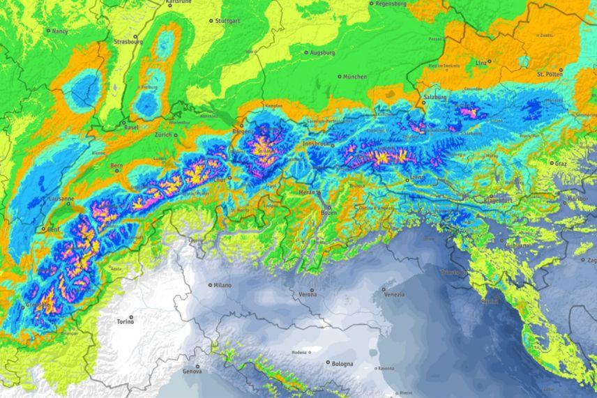 Between now and Monday the heaviest snow (50cm+) will fall across the northern half of the Alps – Image: bergfex.com, 26 November 2021
Detailed snow forecast:
Austria
Saturday will be mostly cloudy in the Austrian Alps, with snow at times and a rain/snow limit dropping to between 300m and 700m.
Sunday will remain mostly cloudy with further snow to very low levels at times in all areas.
By Monday snow showers (to very low levels) will be confined to the northern and western Austrian Alps, while the south (Carinthia, Osttirol) will be drier and brighter.
Between now and Monday evening, between 30cm and 60cm of snow is expected across a wide swathe of the Austrian Alps, though with perhaps a bit less in parts of the far south.
 Light snow today in Mellau in the Austrian Vorarlberg, with more to come this weekend – 26 November 2021 – Photo: mellau.at
France
Saturday will be cloudy in the French Alps, with snow to very low levels at times, heaviest and most persistent in the northern French Alps (e.g. Portes du Soleil, Grand Massif), and more intermittent further south. The far southern French Alps (e.g. Val d’Allos, Auron) will be drier and brighter.
It will remain very cold on Sunday with further snow showers at all levels in the northern French Alps. These flurries will become lighter and more scattered the further south you are, with the southern third of the Alps (roughly south of Serre Chevalier) being mostly dry with sunny spells.
Monday will remain cold with the last of any flurries slowly dying out from the northern Alps. The southern Alps will be mostly sunny, with brighter weather reaching all areas later in the day.
Between now and Monday evening we can expect 30-60cm of new snow in parts of the Haute-Savoie (e.g Flaine, Avoriaz, La Clusaz), and 20-30cm in the Tarentaise and Isère (e.g. Val Thorens, Les Arcs, Alpe d’Huez). Quantities will decrease the further south you are, with perhaps just 5-10cm for the likes of Montgenèvre and Risoul, and nothing at all for Isola 2000.
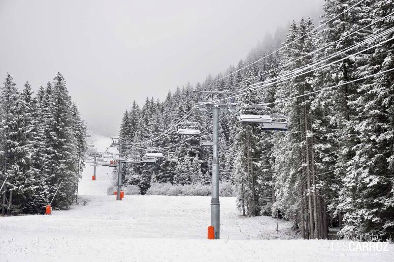 Light snow today in Les Carroz in the Grand Massif, but it will turn much heavier over the weekend – 26 November 2021 – Photo: lescarroz.com
Italy
Saturday will be cold in the Italian Alps, with variable cloud cover and some snow showers to low levels, most of which will be in the east (Dolomites) and the far north-west (e.g. Courmayeur, La Thuile, Cervinia). The far south-west (e.g. Prato Nevoso) will, however, be drier with sunny spells.
It will remain cold on Sunday, with flurries to very low levels close to some border areas, especially in the north-west (e.g. Courmayeur, Cervinia). By contrast, it will be mostly sunny in the far south-west (e.g. Limone, Prato Nevoso), and also in the eastern Italian Alps (i.e. the Dolomites) later in the day, after some early flurries.
Monday will again see a few light flurries close to some border areas but it will generally be sunnier across the Italian Alps, albeit with persistently cold temperatures.
Between now and Monday evening we can expect between 10cm and 30cm of fresh snow across many parts of the Italian Alps, though the southern Piedmont (south of the Milky Way) will probably see next to nothing.
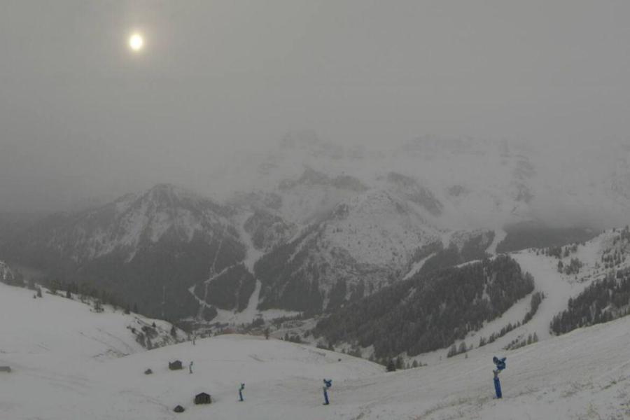 Cloudy today with snow flurries in Arabba – 26 November 2021 – Photo: arabba.it
Switzerland
Saturday will be cloudy in the Swiss Alps, with snow at times (to very low levels), heaviest and most frequent in the northern Swiss Alps (e.g. Gstaad, Wengen, Engelberg). Some parts of the far south (Ticino) may escape with just a few showers or flurries.
Sunday will be cloudy in the central and northern Swiss Alps with further snow showers, heavy at times with snow falling at all levels. Further south there will be fewer flurries, with some sunny spells in the far south.
On Monday the far south (especially Ticino) will remain mostly dry and sunny, while the northern half of the Swiss Alps remain cold with further snow showers to all levels.
Between now and Monday night we are expecting between 30cm and 60cm of new snow across a wide swathe of the northern Swiss Alps (e.g. Villars, Gstaad, Wengen, Engelberg, Laax), with a bit less further south.
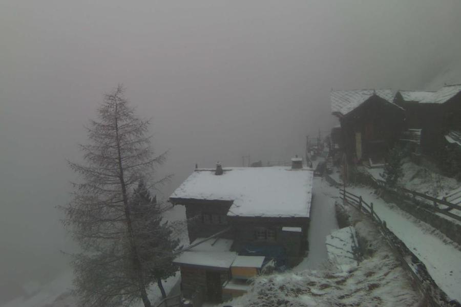 Winter has returned to Zermatt – 26 November 2021 – Photo: zermatt.ch
Outlook:
Tuesday will see some snow at first in the northern and eastern Austrian Alps but for most of the Alps it will be drier and brighter, if still rather cold.
On Wednesday the next major set of weather fronts will approach from the north-west, with further significant snow for many parts of the Alps later in the day and on Thursday.
Our next detailed weather & snow forecast will be
on Friday 3 December 2021
If you enjoy reading our updates - please feel free to support us: