

February Half Term snow report
Updated: 2pm Thursday 10 February 2022
Heading to the Alps next week? Keen to know what weather and snow conditions to expect? As we approach the busiest two weeks of the season (for UK skiers at least), we thought we’d take a closer look at how things are shaping up across the Alps and beyond and bring you an extended half term snow report.
Snow conditions are pretty good across most of the Alps right now, despite snow depths generally being quite modest. Snow depths are currently only above average for the time of year in parts of Austria and eastern Switzerland.
This winter, the southern Alps have generally been drier than the northern Alps, however, the lack of any lengthy periods of excessively warm weather means that on-piste conditions in the south have mostly held up fine so far and should continue to do so for the next couple of weeks.
The only major areas of concern longer term are the southern French and south-western Italian Alps (e.g. Montgenèvre, Risoul, Isola 2000, Auron, Limone, Sauze d’Oulx, Bardonecchia), where the snow pack is extremely thin, with artificial snow heavily in the mix. Some snow is forecast for these drought-stricken southern and south-western parts of the Alps on Monday, but much more will be needed to avert serious problems later in the season.
Snow is also forecast for other parts of the Alps early next week (heaviest in the west), then it is set to turn much warmer from mid-week onwards. There many even be some rain across some north-western parts of the Alps (e.g. Portes du Soleil, Jungfrau region, Arlberg) on Wednesday and Thursday, though details on this are still uncertain. Keep checking Today in the Alps for updates!
Meanwhile, across the pond, the Banff/Lake Louise area continues to offer the best snow conditions in western North America…
Austria
All things considered it has been a good season so far for Austria. Although the southern Austrian Alps (Carinthia and Osttirol) have had a relatively dry season, they’ve still had enough snowfall to ensure reasonable coverage and good on-piste skiing conditions.
Typical of the region is Bad Kleinkirchheim where settled snow depths are currently 40/80cm, a little below average, but perfectly adequate for now. In the far south-eastern Austrian Alps, Nassfeld has done a little better with depths of 60/120cm, pretty close to what you would expect for mid-February, thanks to its exposure to storms coming in off the Adriatic.
After a steady but unspectacular start to the season, snow conditions in the rest of the Austrian Alps (Vorarlberg, Tirol, Salzburgland, Styria, Upper and Lower Austria) have now become very favourable, thanks to a succession of storms from the north that have dumped up to 2m of new snow (and more in places) over the last two to three weeks.
The Arlberg has done particularly well from these storms, with settled snow depths of 155/270cm in Lech and 140/350cm in St Anton, both above average for the time of year. Further east, classic low resorts such as Saalbach (95/160cm) and Kitzbühel (40/110cm) have also done very well from recent storms, with healthy looking base depths as they enter the second half of the season.
 Excellent snow conditions across much of Austria right now. This is St Anton – 10 February 2022 – Photo: foto-webcam.eu
France
This season there has been a stark contrast between snow conditions in the northern and southern French Alps.
Thanks to the big snowfalls early in December, it's been a pretty good season so far in the northern French Alps (roughly to the north of and including Les 2 Alpes and Alpe d’Huez and the 3 Valleys, L’Espace Killy, Paradiski, La Rosière, Grand Massif, Megève, Chamonix, Portes du Soleil). Despite it turning mild and rainy for a time just before New Year, by this stage there was already enough snow on the ground to have guaranteed a solid base for many weeks in even the lower resorts, such as Morzine (40/150cm) and Megève (70/140cm).
Early January also saw further heavy snow, though the month was otherwise relatively dry. So, having been above average across the board in late December, snow depths became more “normal” in early to mid-January, generally falling below average by the end of January.
Early February then saw some moderate snowfalls return to the northern French Alps, meaning means that snow depths are now close to where you would expect them to be mid-season, albeit a fraction below in most cases. Val d'Isère now has settled snow depths of 109/147cm, while Flaine has 90/250cm and Les Gets has 55/150cm.
 Good piste skiing right now in Morzine, where snow depths are not far off what you might expect for mid-February. This is the view from the Chamossière area – 10 February 2022 – Photo: facebook.com/MorzineAvoriaz
The southern French Alps (including the resorts of Serre Chevalier, Montgenèvre, Puy St Vincent, Risoul, Les Orres, Isola 2000 and Auron) have been unusually dry this season. Early December saw snow across all regions, but some of the more southerly resorts (e.g. Isola 2000, Auron) have barely seen anything since. And it shows!
It’s looking more like late April than mid-February in Auron (pictured below), which is skiing on 45cm of almost entirely artificial snow. The situation does get a little less extreme the further north you go but, while there is plenty of good piste skiing to be had in the likes of Montgenèvre (20/40cm) and Puy St Vincent (40/60cm), snow depths remain very modest. Of all the southern French resorts, Serre Chevalier (30/60cm) is probably in the best shape right now.
 Serious shortage of snow in the far southern French Alps right now, though snow is finally forecast here on Monday. This is Auron – 10 February 2022 – Photo: auron.com
As for the forecast, after a few centimetres of snow in some northern parts of the French Alps tonight and early tomorrow (e.g. Grand Massif, Portes du Soleil) a more active storm will bring snow to both the northern and (at last) the southern French Alps on Sunday night/Monday. It probably won’t be a huge dump, but it will certainly be very welcome for the snow-starved resorts of the southern Alps, like Montgenèvre, and Isola 2000.
Later in the week, it will turn warmer again with the risk of some rain in the northern French Alps mid-week but sunshine likely to prevail further south. Watch this space!
Italy
The Italian Alps have had a dry winter to date, with a particularly acute drought in the far south-west where the only significant snowfalls were way back in early December and resorts such as Limone (10/50cm), Prato Nevoso (20/60cm), Bardonecchia (30/60cm), Sauze d’Oulx (20/40cm) and Sestriere (20/40cm) only having seen the odd dusting ever since. These resorts can still offer some reasonable piste skiing right now, but snow depths are extremely modest for the time of year, with lots of artificial snow in the mix.
Elsewhere in the Italian Alps, the situation is better thanks to some occasional top-ups, but snow depths are still below average. The Dolomites did see some snow last week and are skiing quite nicely right now. Val Gardena currently has 25/80cm, while Madonna di Campiglio has 20/75cm. However, more snow will be needed to avoid problems later in the season. If you are looking beyond half term and towards Easter, the higher resorts of Cervinia (75/175cm) and Livigno (70/95cm) are among the safer bets.
As for the outlook, some snow is forecast early next week across the Italian Alps, including where it is most needed in the south-west. It probably won’t fall in huge quantities, but any new snow here will be welcome. From mid-week onwards it should then turn drier and sunnier, but it will also become very mild.
 Good piste skiing in the Italian Dolomites right now, even if snow depths remain relatively modest. This is Madonna di Campiglio– 10 February 2022 – Photo: funiviecampiglio.it
Switzerland
The Swiss Alps have had a pretty good first half of the season, getting off to a strong start with a sucession of storms in early to mid-December which particularly benefited the northern and western Swiss Alps (e.g. Engelberg, Mürren, Villars, Morgins). Warmer weather (and some rain) spoilt the party just after Christmas, but new snow then improved conditions for early in the New Year.
January was generally then quite dry, with snow depths falling well below average in most resorts mid-month before a succession of storms improved conditions later in January and into the first part of February.
Snow depths are now close to or a little above average for mid-February in the eastern half of the Swiss Alps (from about Andermatt eastwards) including the likes of Laax (60/270cm), Davos and Klosters (110/185cm). Elsewhere in the Swiss Alps, snow depths are perfectly reasonable but generally slightly lower than you might expect mid-season. In the south-west, Zermatt, for example, has 45/125cm depending on altitude, while in the far south-east, St Moritz has 40/75cm.
Some light snow is forecast in Switzerland tonight and tomorrow, mostly affecting the northern half of the Swiss Alps (e.g. Villars, Wengen, Engelberg). After a couple of fine weather days on Saturday and Sunday, more snow should then arrive from the west on Sunday night/Monday.
At this stage, the heaviest snow from this storm is likely to fall in the far west (e.g. Portes du Soleil) and the far south-east (e.g. St Moritz), though there is still uncertainty over the details at this stage. From mid-week onwards, temperatures are set to turn much milder again with the chance of some rain in the northern and western Swiss Alps. It’s too far out to be certain though, so stay tuned!
 Davos is skiing as well as anywhere right now thanks to a succession of storms that have hit the region in the last fortnight or so – 10 February 2022 – Photo: facebook.com/DavosKlosters
Rest of Europe
Snow cover is still pretty good across most of the major Pyrenean resorts, largely thanks to a series of big snowfalls early in the season. Andorra’s Granvalira now has settled snow depths of 80/130cm while Spain’s Baqueira Beret has 135/235cm. A moderate fall of snow is expected in the Pyrenees early next week, after which it will turn sunnier and warmer.
Snow depths remain modest across much of Norway but there is still some good piste skiing on offer in both Geilo (40/60cm) and Hemsedal (25/40cm), with some snow forecast in both resorts early next week.
It’s finally looking a bit wintrier in the Scottish mountains, though more snow is still needed for any serious skiing to be had. Right now, skiing is limited to the beginner areas in Glencoe, Cairngorm, the Lecht and Glenshee. Additional areas may open up over the next few days, but this depends a lot on the weather, especially the wind. Do check the lift ticket status in any individual resort before setting out, as ticket sales are limited and they may already be sold out for specific periods.
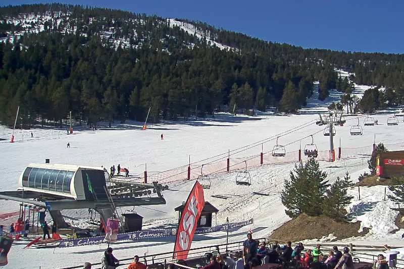 Good snow conditions across most of the Pyrenees right now. This is Formiguères in the eastern French Pyrenees – 10 February 2022 – Photo: snow-eye.com
USA
Snow depths across most of the US are generally below where they should be mid-season. One exception is California where, despite the recent dry weather, depths are closer to average thanks to the big storms earlier in the year. Mammoth currently has 175/355cm depending on altitude, while Squaw has 125/250cm.
There is still plenty of good piste skiing to be had in the US though, including in Colorado’s Vail (45/130cm) and Montana’s Big Sky (55/125cm), but powder lovers will have to wait a little longer for any serious dumps.
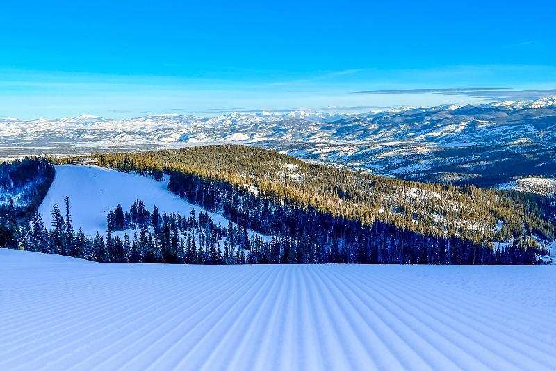 Perfect pistes in Colorado’s Winter Park this week, even if snow depths here are relatively modest – 10 February 2022 – Photo: facebook.com/WinterParkResort
Canada
Since we last reported a week ago, there has only been 13cm of new snow in Whistler (236cm upper base) but conditions are still pretty good, especially at altitude, although milder weather has meant more variable snow quality lower down.
Further inland, a 15cm top-up in the Lake Louise/Banff (150/215cm) area will ensure that snow conditions remain excellent here over the next few days.
The forecast for the next few days is for mostly dry weather and relatively mild temperatures.
Our next full snow report will be on
Thursday 17 February 2022
If you enjoy reading our updates - please feel free to support us: