


Updated: 9.50am Monday 30 October 2017 - Best snow still on the Austrian glaciers
As expected, yesterday was a very stormy day in the Alps with wind speeds of over 150 km/h recorded in several locations. There was also some snow, chiefly in Austria, as well as the northern and eastern Swiss Alps (e.g. Engelberg), with a rain/snow limit eventually dropping to 1500m or lower overnight.
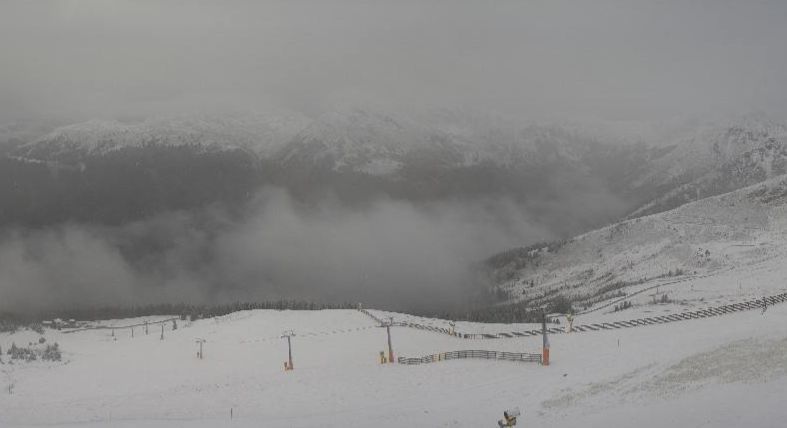
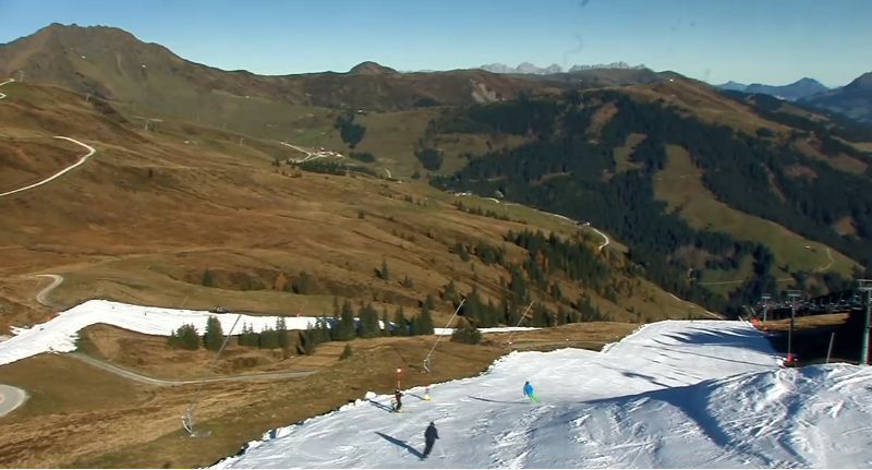
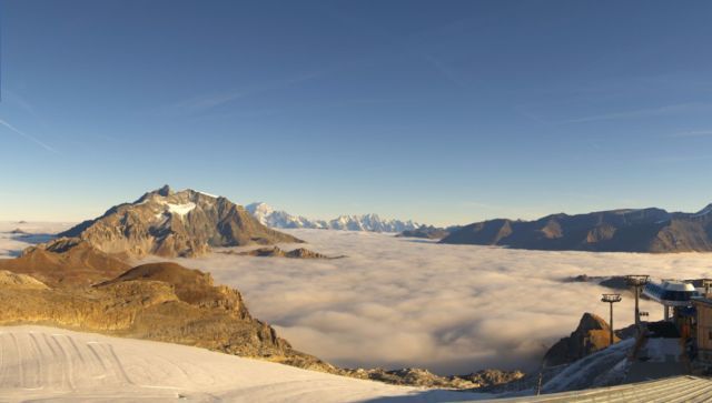
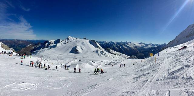
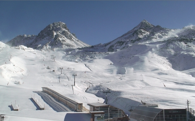 Non-glacial Ischgl now has enough snow on its upper runs to start preparing its base – 30 October 2017 – Photo: ischgl.com
Today the last of the showers are moving away from the eastern Austrian Alps leaving most areas with a dry and bright day. This fine weather will last for much of the week, with no more snow forecast until next weekend at the earliest.
So how are snow conditions in the Alps shaping up as we approach November?
The eastern Alpine glaciers are doing pretty well right now - especially the Austrian ones - thanks to the regular top-ups of snow over the last few weeks. Our recommendations for some of the best skiing in the Alps this week include Hintertux, Kaprun, Stubai and Sölden.
Switzerland’s Engelberg has also seen some decent snowfall in recent days but further south and west, any snowfall has generally been lighter and patchier. So while skiing in the likes Zermatt, Cervinia, Saas-Fee, Val Senales, Passo Stelvio and Tignes is still ok, it is not as good as in Austria.
It is also worth noting that one or two non-glacial resorts have started to work on their base for the coming season. Ischgl, for example, now reckons it has enough snow on its upper slopes to last until opening (23 November 2017) and has also decided to turn on the snow cannons.
This is the exception rather than the rule, however, and for the vast majority of Alpine resorts, proper piste preparation is still some way off (as you would expect at this time of year).
Updated: 3pm Saturday 28 October 2017 - Relative calm between weather fronts
It snowed across parts of the northern Alps yesterday, especially in Austria where most of the glaciers are now in excellent shape. After a relative calm today, further weather fronts are set to arrive from the north on Sunday.
 Lying snow (from Friday) at resort level in Obertauern – 28 October 2017 – Photo: obertauern.at
The heaviest snow will again be in the north-eastern Alps, from central Switzerland (e.g. Engelberg) eastwards to include much of the Austrian Alps away from the far south.
By Monday morning we can expect a further 10-30cm (locally 40cm+) of new snow across glaciers such as Engelberg, Sölden, Stubai, Hintertux and Kitzsteinhorn. However, this snow will be accompanied by very strong winds which will hamper lift operations.
The weather in the Alps will improve during the first part of next week.
Updated: 8.15am Thursday 26 October 2017 - More snow for the northern Alps this weekend
After several days of mostly fine weather in the Alps, it is about to turn more unsettled again with a series of fronts bringing further rain and snow in places (mostly the north) between Friday and Monday.
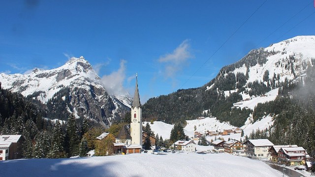
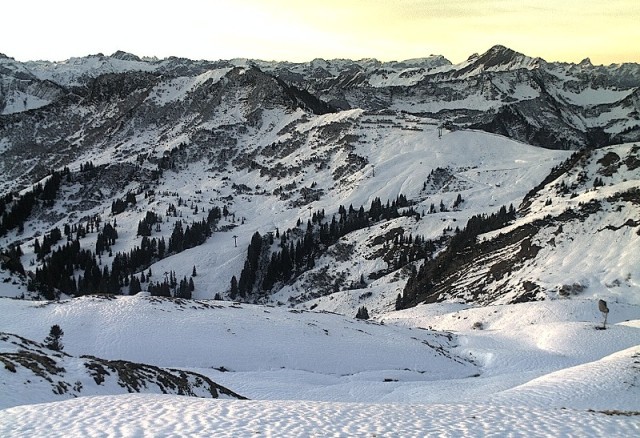 Last weekend’s snow in the Damüls-Mellau region is thinning but more is expected over the next few days, especially on Sunday – 26 October 2017 – Photo: mellau.at
After another lovely day today the first, relatively weak, weather front will reach the northern Alps on Friday bringing a little high altitude snow in places, mostly to the northern Swiss (e.g. Engelberg) and Austrian (e.g. Kitzsteinhorn) Alps with a rain/snow limit descending from 2500m to 2000m or lower (especially in Austria) later in the day.
After a period of relative calm on Saturday, a more active cold front will bring more significant snow to the northern half of the Alps on Sunday, again favouring the northern Swiss and Austrian Alps. The northern French Alps (e.g. Tignes) are only likely to see small quantities of snow, while much of the southern Alps will miss out altogether.
Right now you can ski on all eight Austrian glaciers (Hintertux, Sölden, Mölltal, Pitztal, Kaunertal, Stubai, Kaprun, Dachstein). You can also ski in Kitzbühel on a strip of “old snow” specially preserved from last season.
In Switzerland you can ski in Zermatt, Saas-Fee, Engelberg, Diavolezza (near St Moritz) and, as of this weekend, Glacier 3000 near Les Diablerets.
In Italy you can ski in Val Senales, Passo Stelvio and (as of this weekend) Cervinia, which had previously only been open at weekends only. Non glacial Sulden in the Südtirol is expected to open on 1 November.
In France, Tignes remains the only option.
Updated: 9.35am Tuesday 24 October 2017 - Storm dies out but another is brewing for the weekend
The last of the snow flurries from the current storm are dying away from the eastern Alps (i.e. Austria). The weather will now be mostly fine and increasingly mild over the next few days. However, new fronts will approach the northern Alps later in the week with the prospect of further snow on the northern side of the Alps towards the weekend.
 Significant fresh snow in the northern Alps over the last couple of days. This is Braunwald – 24 October 2017 – Photo: braunwald.ch
Since Saturday we have seen between 10cm and 30cm (above 2000m) quite widely across the northern half of the Alps, with 50cm or more locally, especially in the northern Swiss Alps. The rain/snow limit has also been quite low with a temporary dusting to 1000m in one or two spots.
This is great news for the glaciers, of course, but it is still too early to be getting excited about what the main season might hold. That said, there are some indications that the underlying weather pattern will favour further significant snowfalls over the next couple of weeks – watch this space…
Updated: 9.30am Monday 23 October 2017 - Significant snow for some northern parts of the Alps
As expected, many northern parts of the Alps have seen some significant snow over the last 24 hours, especially at altitude, although there is a dusting as low as 1000-1200m in places.
 New snow in Lech this morning – 23 October 2017 - Photo: lech.com
The heaviest snow has fallen in a line from the French Haute Savoie (e.g. Avoriaz, Chamonix), right through the northern Swiss Alps (e.g. Bernese Obreland, Engelberg) and into the Austrian Vorarlberg, parts of the Tirol and Salzburgland.
Above 2000m these areas have mostly seen in the region of 10-30cm of new snow, with 40-50cm in some places, and there’s more to come today. By contrast, the southern Alps have missed most of the snow.
This wintry spell will continue for 36 to 48 hours before warmer and sunnier weather establishes itself once more by the middle of the week, which will quickly melt much of the low lying snow. Early indications suggest that another wintry blast is possible for the northern Alps next weekend, but it is too early to firm up on details just yet.
Weather permitting you can currently ski on all glaciers in Austria - Hintertux, Stubai, Sölden, Mölltal, Pitztal, Kaunertal, Kitzsteinhorn and Dachstein. You can also ski in non-glacial Kitzbühel on a strip of “artificial” snow which has been specially preserved from last winter.
In France the only option available is Tignes. In Switzerland you can ski on the glaciers at Zermatt, Saas-Fee, Engelberg and now Diavolezza near St Moritz. In Italy you can currently ski at Val Senales and Passo Stelvio, with Cervinia (which has already opened at weekends) set to open daily from this Saturday.
Updated: 11am Sunday 22 October 2017 - Temporary taste of winter
As predicted, snow is falling across some parts of the Alps today, mostly in the north. This wintry spell will continue until Tuesday, by which point high pressure will start to reassert its influence from the west.
 Fresh snow this morning above Saalbach-Hinterglemm in Austria – 22 October 2017 - Photo: saalbach.com
By Tuesday we can expect somewhere between 10cm and 30 cm of new snow to have fallen above 2000m across quite a wide swathe of the northern Alps, with 50cm or more locally. The rain/snow limit will be between 1000m and 1600m which means a temporary dusting to relatively low levels too.
But while this is great news for the glaciers, don’t get too excited for the Alps as a whole as rising temperatures will melt most of any lower lying snow by the end of next week.
We will bring you more details on how much snow has fallen and what’s open on Monday morning.
Updated: 9.20am Friday 20 October 2017 - Significant snow in the forecast - but…
There is some significant snow on its way for parts of the Alps this weekend, especially on Sunday and in the North and East. But don’t get too excited - sunny and increasingly warm weather will return by the early/middle part of next week sending the snow-line scurrying back up the mountain.
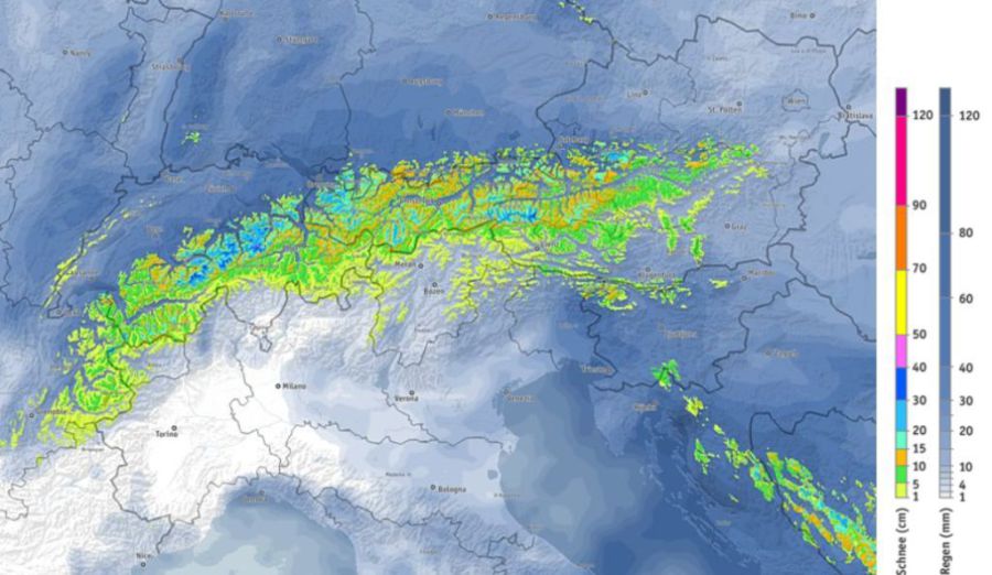
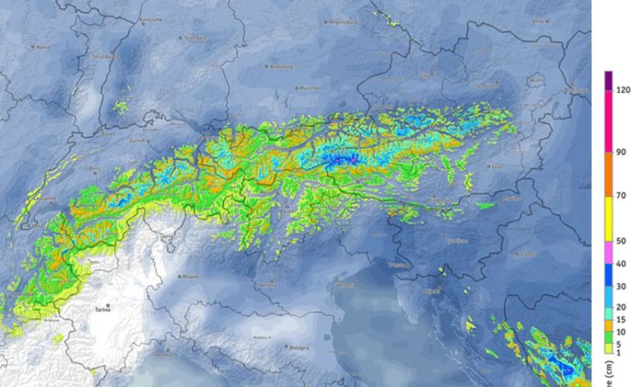 Predicted snowfall between now and Tuesday 24 October 2017 – Image: bergfex.com
After a largely fine day today the weather will deteriorate on Saturday with showers across the northern Alps and a rain/snow limit descending to between 2000m and 2500m later in the day.
Sunday and Monday will see further precipitation, mostly across the northern half of the Alps, with the snow-line descending to somewhere between 1000m and 1600m. Tuesday will see the last of the showers and flurries die away from the eastern Austrian Alps to leave most areas fine and increasingly mild again.
Between Saturday and Tuesday we could see 50cm of more snow new snow above 2000m in some northern parts of the Alps, more generally 10-40cm.
What do we mean by the northern Alps? This would encompass the French Alps roughly north of Grenoble, most of the Swiss Alps except the far south (Ticino), and most of the Austrian Alps except for Carinthia and parts of the Osttirol. The Italian Alps are generally considered to be in the “south”, though some border areas could still see some significant precipitation in these circumstances.
As mentioned earlier, any low-lying snow will quickly melt again next week but at high altitude it could stick around for a while and this will be a welcome top up, for the glaciers at least.
Updated: 9.15am Wednesday 18 October 2017 - Still warm, some snow in places this weekend
The weather in the Alps continues to be mostly sunny and very mild. It will turn temporarily cooler and more unsettled over the weekend (with some snow in places) before southerly winds bring the warm air back next week.
 Pistes looking a little worn on the Grande Motte glacier above Tignes where a modest top-up of snow is possible on Sunday – 18 October 2017 – Photo: tignes.net
Good skiing is still possible on the glaciers, especially in Austria where you can ski at Hintertux, Stubai, Sölden, Mölltal, Pitztal, Kaunertal, Kitzsteinhorn and Dachstein. You can also ski in non-glacial Kitzbühel on a strip of “artificial” snow, specially preserved from last winter.
In France the only option is Tignes. In Switzerland you can ski on the glaciers above Zermatt, Saas-Fee and Engelberg and in Italy you can ski at Val Senales, Passo Stelvio and Cervinia, the latter opening at weekends only until 28 October, when it starts to open daily.
Updated: 12.10pm Monday 16 October 2017 - Still warm in the Alps
The weather in the Alps remains warm, with temperatures well into the 20°Cs again in many of the lower lying valleys.
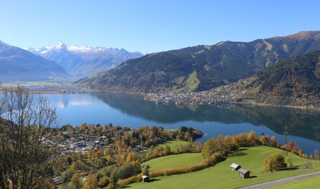 Magnificent weather in the Alps today. This is Zell-am-See with the Kitzsteinhorn glacier (Kaprun) in the background – 16 October 2017 – Photo: zellamsee-kaprun.com
Needless to say, any of the lower lying snow from recent storms has long melted, but good skiing is still possible on the glaciers - especially in Austria, where you can ski at Hintertux, Stubai, Sölden, Mölltal, Pitztal, Kaunertal, Kitzsteinhorn and Dachstein. You can also ski in non-glacial Kitzbühel on a strip of “artificial” snow specially preserved from last winter.
In France the only option is Tignes. In Switzerland you can ski on the glaciers above Zermatt, Saas-Fee and Engelberg and in Italy you can ski at Val Senales, Passo Stelvio and Cervinia, the latter opening at weekends only until 28 October, when it starts to open daily.
The weather in the Alps will turn a bit more unsettled later in the week and over the weekend, with a little high altitude snow in places, though probably nothing too significant at this stage.
Updated: 10.15am Sunday 15 October 2017 - Indian summer
There is some beautiful weather in the Alps right now – but it is very warm, which means that most of the lower lying snow from the recent storms has long melted.
 Skiing started this weekend in non-glacial Kitzbühel thanks to snow specially preserved from last season – 15 October 2017 – Photo: kitzski.at
Temperatures will be into the low 20°Cs in many of the lower valleys over the next couple of days. However, it will cooler and more unsettled later in the week with the prospect of some more high altitude snow in places. There may be some more significant and widespread snow by next Sunday but that’s a long way off, so watch this space.
In the meantime, there is still some good glacier skiing to be had in the Alps, especially in Austria where all eight glaciers are open for business. You can also now ski in non-glacial Kitzbühel thanks to the somewhat gimmicky annual October opening of the Resterhöhe area, on snow specially preserved from the previous winter.
In France the only option right now is Tignes. In Switzerland you can ski on the glaciers above Zermatt, Saas-Fee and Engelberg. In Italy you can ski at Val Senales, Passo Stelvio and Cervinia, though the latter is currently only open at weekends, but will start to open daily on 28 October.
Updated: 9.35am Thursday 12 October 2017 - Les 2 Alpes cancels autumn half-term opening
Les 2 Alpes has taken the decision to cancel its traditional Autumn half-term opening due to poor snow conditions on the glacier.
 Les 2 Alpes will not open this Autumn half-term as planned – 12 October 2017 – Photo: les2alpes.com
As regular readers of weathertoski will know, it was an exceptionally hot and dry summer in the Alps. Although there has been snow this Autumn, most of it has fallen in the east (i.e. Austria), with only lighter, more sporadic falls further west (e.g. Zermatt, Tignes, Les 2 Alpes).
All in all, Les 2 Alpes has concluded that there is still insufficient snow to offer decent snow conditions this half term – no doubt they will also have noticed that it is forecast to remain warm and sunny for the next week at least.
In France, the only option for the next few weeks will therefore be Tignes. In Italy, you can currently ski on the glaciers at Val Senales and Passo Stelvio, with Cervinia set to join them (at weekends only) this weekend and next, before opening daily from 28 October. In Switzerland you can ski in Zermatt, Saas-Fee and Engelberg.
However, the best snow conditions are in Austria where all the glaciers are open – Dachstein, Kitzsteinhorn, Stubai, Sölden, Hintertux, Pitztal, Kaunertal and Mölltal. Of these, Hintertux currently offers the greatest extent of skiing, with 35km of pistes served by 14 lifts.
Updated: 9.20am Wednesday 11 October 2017 - Austria continues to offer the best snow conditions in the Alps
Engelberg opens its Titlis glacier for skiing today, joining Zermatt and Saas-Fee as Switzerland’s third option during this pre-season period. The weather will be sunny and mild at altitude in the Alps today, as it will be (give or take) for the next few days.
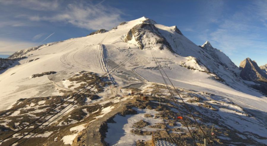
 Excellent snow conditions on the Hintertux glacier in Austria right now – 11 October 2017 – Photo: facebook.com/Hintertux.Glacier
In Italy you can currently ski on the glaciers at Val Senales and Passo Stelvio, with Cervinia set to join them (at weekends only) this weekend and next before opening daily from 28 October.
In France you can ski on the glacier above Tignes, with Les 2 Alpes the next to open (for half term only) from 23 October to 1 November. The best snow conditions, however, are in Austria where all the glaciers are open – Dachstein, Kitzsteinhorn, Stubai, Sölden, Hintertux, Pitztal, Kaunertal and Mölltal. Of these Hintertux currently offers the greatest extent of skiing, with 35km of pistes served by 14 lifts.
Updated: 12.30pm Tuesday 10 October 2017 - Turning warm
High pressure will dominate the weather in the Alps this week. Yes, the occasional weak weather front will try to invade from the north, but it won’t amount to more than a little cloud, with just about everywhere staying dry, bright and increasingly warm.
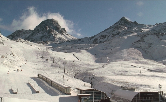
 View from Engelberg’s Titlis glacier, which opens for skiing tomorrow (Wednesday) – Photo: titlis.ch
Indeed, temperatures could rise into the low 20°Cs in some of the lower valleys as the week goes on, which will quickly melt any low-lying snow. On the glaciers, however, there is still some good skiing to be found, especially in Austria where most of the recent snow has fallen.
One resort to have also seen significant snow is Switzerland’s Engelberg, which will open its Titlis glacier for the first time this season tomorrow.
Updated: 9.50am Monday 9 October 2017 - A mild and mostly dry week ahead for the Alps
The weather is now settling down again following an unsettled weekend which saw further snow across some northern and eastern parts of the Alps.
 View from the Grande Motte glacier this morning above the clouds looking down towards Tignes – 9 October 2017 – Photo: tignes.net
Right now snow conditions are excellent across the eastern Alpine glaciers (i.e. Austria), but more average further west (e.g. Tignes) where more snow would be welcome. However, there isn’t really much sign of that in the forecast. Weather fronts will skirt the northern fringes of the Alps from time to time this week but most places will stay dry and it will be quite mild.
In the meantime you can ski on thirteen glaciers across the Alps right now, with more due to open in the coming days/weeks. In France, Tignes opened its Grande Motte Glacier on 30 September and is currently the country’s only option. Les 2 Alpes will join it for half-term (21 October to 1 November).
In Switzerland you can ski on the glaciers in Zermatt and Saas-Fee, soon to be joined by Engelberg, Glacier 3000 (near Les Diablerets) and Diavolezza (near St Moritz).
In Italy you can ski on the glaciers at Val Senales and Passo Stelvio, with Cervinia opening for weekend skiing on 14/15 and 21/22 October then daily for the season from 28 October.
Austria, as is normal at this time of year, has the most options right now, with skiing possible at Hintertux, Sölden, Stubai, Pitztal, Kaunertal, Mölltal, Dachstein and the Kitzsteinhorn glacier above Kaprun.
Updated: 11.25am Saturday 7 October 2017 - Fresh snow for some northern and north-eastern parts of the Alps, with more forecast tomorrow
This is how Warth-Schröcken in Austria’s notoriously snowy Vorarlberg looked this morning. Most of the snow from this storm has been focussed on the north-eastern quarter of the Alps from about central Switzerland eastwards.
 Fresh snow to quite low levels across some northern and north-eastern parts of the Alps this morning. This is Schröcken (1260m) – 7 October 2017 – Photo: warth-schroecken.com
By contrast, the southern and western Swiss Alps (e.g. Zermatt), the southern Austrian Alps (e.g. Nassfeld), as well as the French and Italian Alps, have seen little if any snow.
Today the last of the showers will die out from the eastern Austrian Alps to leave most places with a fine and very mild day. However, Sunday will see further fronts affect the northern and particularly north-eastern Alps again with further showers and some snow above 1500-2000m.
We should emphasise that while this new snow is great news for the eastern glaciers (mostly Austria) it is still meaningless in the wider context of the coming winter.
Updated: 9.40am Friday 6 October 2017 - Further top-ups for the eastern glaciers
There is a little fresh snow across some northern and eastern parts of the Alps this morning with more to come today.
 Fresh snow above Ischgl this morning – 6 October 2017 – Photo: ischgl.at
It won’t be a huge amount but is great news for the Austrian glaciers, where conditions are already good for early October. The western glaciers (e.g. Tignes, Zermatt) will miss most of the snow from this latest storm and could do with another top up.
The weather will remain unsettled over the weekend, turning milder for a time on Saturday, then cooler again on Sunday.
Updated: 9.10am Wednesday 4 October 2017 - Warm today, colder with snow in places by Friday…
There was a bit of high altitude snow in the Alps yesterday (Tuesday), but nothing really significant, and today it is fine again with freezing levels between 3000m and 4000m.
 The Grande Motte glacier above Tignes is starting to look a little threadbare again, at least lower down – 4 October 2017 – Photo: tignes.net
After another mild and mostly dry day tomorrow, some more significant snow is forecast on Friday, especially for the Austrian and central/eastern Swiss Alps, with a rain/snow limit temporarily as low as 1200m later on Friday.
While this is great news for the eastern Alpine glaciers (especially in Austria) it is worth noting that the southern and western glaciers (e.g. Zermatt, Saas-Fee and Tignes), which already have less snow, will only see a dusting from this next storm.
 Snow conditions are better on the eastern Alpine glaciers than on the western ones. This was how Hintertux looked on Monday (2 October 2017) – Photo: facebook.com/Hintertux.Glacier
Updated: 9.40am Tuesday 3 October 2017 - An unsettled week in the Alps, with further (mostly high altitude) snow in places
It’s wet across many parts of the Alps this morning, especially in the north where some snow is falling at high altitude.
 Predicted accumulated snowfall over the next seven days – Image: bergfex.at
Generally speaking, the rain/snow limit will remain between 2500m and 3000m, but it will dip towards 2000m in the north-eastern Swiss and northern Austrian Alps for a time this afternoon.
Tomorrow will be drier and very mild again in the Alps, before further weather fronts arrive from the north-west later in the week. These weather fronts could bring some more significant snow to the eastern Alps on Friday and Saturday (especially Austria) with snow falling to relatively low levels for a time.
Updated: 9.54am Monday 2 October 2017 - Good conditions on the glaciers
Welcome back to ‘Today in the Alps’, our daily round-up of weather and snow conditions in the Alps running from now until the end of April 2018. Our twice weekly detailed snow forecasts and snow reports will follow in early November.
 Hintertux often offers the best snow conditions in the Alps at this time of year and the last few weeks have been no exception - 2 October 2017 - Photo: facebook.com/hintertux.gletscher
Anyone that has been following weathertoski's Snow news this summer will know that there was plenty of snow in the high Alps in September, a month that ended up several degrees colder than average overall. While this was great for the glaciers (which had endured a torrid summer) it doesn’t, unfortunately, mean anything in terms of what we can expect this winter.
That said, there is some more snow in the forecast – with a dusting at high altitude on Tuesday, followed by some more significant snow for the northern and eastern Alps in particular later in the week.
 Mölltal is another good glacier option right now - Photo: gletscher.co.at