


ARCHIVE
Today in the Alps - November 2024
Read about current weather and snow conditions in the Alps
Updated: 3pm Saturday 30 November 2024 – Pleasant on-piste skiing conditions in the Alps this weekend…
High pressure is in charge of the weather in the Alps this weekend, bringing plenty of sunshine (at least at altitude) and pleasant enough temperatures, although it will feel cold if you are trapped under low cloud in some of the valley bottoms.
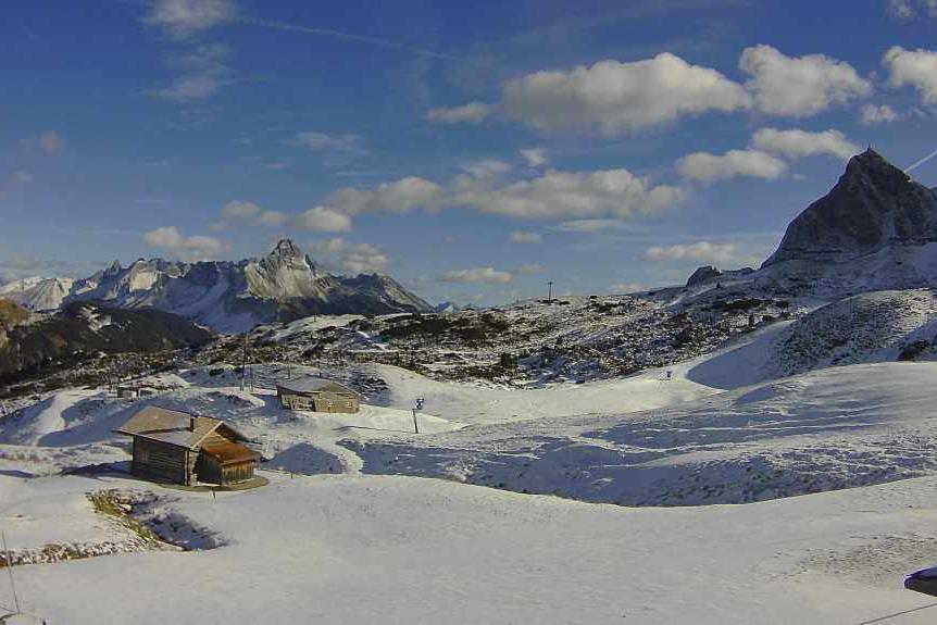
 Skiing on hard-packed pistes but under blue skies this weekend in Obertauern – Photo: foto-webcam.eu, 30 November 2024
The next snow in the Alps is expected on Monday with the arrival of weak cold front that will deliver a few centimetres of snow to many north-western parts of the Alps (e.g. Avoriaz, Engelberg, Arlberg).
With mostly sunny skies, skiing conditions in the Alps this weekend are generally very pleasant. Most of the last couple of weeks’ snow has fallen in the north-western Alps but it has been very wind-blown, meaning that the off-piste is often threadbare at altitude or in exposed areas.
The best natural snow cover remains at altitude in the north-western Alps (e.g. Tarentaise, Verbier, Davos), however, some lower resorts, including in the southern Alps and especially the Dolomites are also open thanks to considerable artificial help.
A large number of resorts have opened in the Alps this weekend, taking the number of possible options for skiing to close to 100, albeit most of these are open on an extremely limited basis. Among the best options right now include Tignes, Val Thorens, Zermatt/Cervinia, Verbier, Ischgl, Sölden and Obergurgl, but there are many more besides.
Updated: 3pm Tuesday 26 November 2024 – A little top-up of snow today in some northern parts of the Alps…
A weak cold front is currently crossing the Alps. This delivered a few centimetres of snow above about 1800m to some northern regions last night, with an additional dusting expected in places today, albeit not adding up to much. However, this front signals the end to a brief but very mild spell of weather on over the past two days which saw freezing levels exceed 3000m for a time.
 Modest snow cover lower down in the Zell-am-See area, but plenty at altitude in neighbouring Kaprun (to the far left in the background) – Photo: foto-webcam.eu, 26 November 2024
Another, relatively weak, cold front will cross the Alps on Thursday bringing a further modest top-up of snow to some northern parts of the Alps with a rain/snow limit falling from about 1800-2000m to 1000-1500m, lowest in Austria.
Following last week’s big storms, snow cover remains relatively impressive at high altitude across the north-western Alps (e.g. Tignes, Verbier, Zermatt, Engelberg). Lower down and further east or south, snow cover is more modest or patchy, but this is entirely normal for the time of year.
Some of the best skiing for now can be found in the likes of Tignes, Val Thorens, Zermatt, Saas-Fee, Verbier, Cervinia, Sölden, Obergurgl and Hintertux.
Updated: 10am Thursday 22 November 2024 – Record-breaking November snowfalls for some of the foothills of the Alps!
As expected, many western/north-western parts of the Alps saw further significant snow yesterday (Thursday), with flurries continuing to fall to low levels across some northern areas today. More extraordinary was the amount of snow that fell in the foothills of the north-western Alps and the adjacent lowlands, however. Here areas like Lucerne saw 40cm+ and the Basle region saw 25cm – both being record-breaking snowfalls for November.
 Lots of snow in Tignes, which looks more than ready for its opening tomorrow – Photo: tignes.net, 22 November 2024
In the Alps themselves, another 20-50cm fell across a wide swathe of the north-western Alps (roughly from Grenoble through much of Switzerland and into the west of Austria). The far north-west of Italy also did well. Further east, much of Austria also saw at least a few centimetres of snow (with much more in the far west). There was also a sprinkling in the Dolomites which, despite not having seen that much snow fall this week, have been able to operate their snowmaking at full throttle thanks to the cold temperatures.
Resorts that have done best this week are those in France, Switzerland and the far north-west of Italy. Snowfall totals recorded since Monday are unreliable due to strong winds, but are certainly in the 80-120cm range (with 150cm+ in places) above 2200m in the likes of Tignes, La Rosière/La Thuile, Verbier, Zermatt and Engelberg, to name just a few.
This is great news for early season conditions in these higher resorts though, with temperatures turning much milder over the weekend, much of any lower lying snow will quickly melt, especially across the northern Alps where the Foehn will blow, and freezing levels will rise to 3500m for a time. More on this in our detailed snow report later today…
Updated: 3pm Wednesday 21 November 2024 – New storm incoming for the Alps, but it will be much milder next week…
Another storm will hit the Alps today, again favouring the western Alps in terms of snowfall. Snow flurries will linger across some northern regions for a while tomorrow before it turns drier and milder on Saturday.
 Lech has done better than most of Austria from this week’s storms – 21 November 2024 – Photo: lechzuers.com
This new storm will deliver another 30-40cm (and a bit more in places) across many western Alpine regions, with the northern French Alps (e.g. Tignes, La Plagne) and western Swiss Alps (e.g. Verbier, Zermatt) again most favoured. Generally, the further east you go the less snow will fall, with only a few centimetres due across much of Austria (with a bit more in the far west) and little more than a dusting in the Dolomites.
Today’s rain/snow limit will start low, and remain low in the more internal valleys, but will rise to 1500m or so for a time in more exposed parts of the western Alps before falling again later.
By tomorrow, storm snowfall totals for this week are likely to be in the region of 1m or more in some favoured western parts of the Alps (e.g. Tarentaise). However, any lower lying snow will quickly melt next week thanks to much milder weather, including Foehn conditions in the northern Alps. In short, this week’s storms have been great news for many high resorts (especially in France, western Switzerland and the far north-west of Italy) but they won’t mean very much lower down.
That said, the colder temperatures have allowed snow-making to operate at high capacity this week, allowing areas like the Dolomites and parts of Austria (that have missed the heaviest snow this week) impressive pre-season on-piste coverage.
Updated: 3pm Wednesday 20 November 2024 – Significant snow in the western Alps, though it will warm up again this weekend…
It’s looking much more wintry today across much of the Alps, especially in the west where significant snow has fallen at altitude over the last 24 hours, with 40-60cm already at high altitude in the French Tarentaise region.
 Snowy scenes in Les Saisies (1600m) in the French Alps this afternoon – 20 November 2024 – Photo: lessaisies.com
Snow flurries will continue to low levels across the north-western Alps today and, for a time, tonight before easing later.
On Thursday a major new storm will reach the Alps from the west and influence the weather well into Friday. This latest storm will again most favour the western Alps where another 30-60cm of snow is likely in the French Alps (e.g. La Rosière, Val d’Isère), the western Swiss Alps (e.g. Verbier, Zermatt) and the north-western Italian Alps (e.g. La Thuile, Courmayeur, Cervinia). The Austrian Alps, central and Italian Alps will also see some snow, but in much lesser quantities.
The situation with the rain/snow limit on Thursday will be a little complicated, starting very low with widespread snow right into the lowlands, and probably remaining low for some time in many of the internal Alpine valleys (e.g. Haute-Tarentaise, Zermatt). However, it will quickly rise to 1500m or higher close to the western foothills before falling again everywhere later in the day. Flurries will continue to low levels across the northern Alps for a time on Friday before starting to ease again later in the day.
Snowfall totals from this storm cycle (between Tuesday and Friday) are likely to exceed 1m above 2200m across many north-western parts of the Alps, including Val d’Isère, Val Thorens, Verbier and Zermatt. On the whole, the further east and south-east you are the less new snow there will be. In Austria the greatest falls will be in the far west, with significant snow in the Arlberg region but much less in the Salzburgland, for example. The central and eastern Italian Alps (e.g. Dolomites) will also miss the heaviest of the snow this week.
Over the weekend it will turn drier and milder. It will be very mild early next week when a strong Foehn is likely across the northern half of the Alps, which will quickly melt any of the lower-lying snow from this week’s storms.
Updated: 2pm Monday 18 November 2024 – Heavy snow for the western Alps this week…
The first front of this week’s much-anticipated storm cycle has now reached the Alps although, as expected, it has been a very weak affair with just a sprinkling of snow above 1600m in some parts of the northern Swiss and Austrian Alps. More potent storms are forecast this week, with the heaviest snow in the west.
 Just a sprinkling of snow overnight in some northern parts of the Alps, such as here in Warth-am- Arlberg. The serious storms begin later tomorrow with the heaviest snow due in the western Alps – Photo: snoweye.com, 18 November 2024
The real action will begin later tomorrow and on Wednesday when heavier and more widespread snow will fall in the north-western Alps – i.e. most of the French Alps, except the far south, and the northern and western Swiss Alps (e.g. Verbier, Mürren) – where between 30cm and 60cm will fall by the end of Wednesday.
The far north-west of Italy (e.g. Courmayeur, La Thuile) will also do well, but the further east and south-east you go, the less snow will fall, with only a few centimetres for much of Austria and little, if any, in the Dolomites. The rain-snow limit in this first major storm will start at around 1400-1600m before falling to very low levels on Wednesday morning.
A second major storm will follow on Thursday but with a slightly more southerly track than originally forecast, meaning that the whole of the French Alps will be affected, both north and south, as well as the western Italian Alps (e.g Milky Way). However, the Austrian and eastern Italian Alps will again see much less snow.
The rain-snow limit of this second storm will start at very low levels, perhaps rising briefly to above 1000m in places before falling again late on Thursday. This second storm is expected to deliver another 25-50cm of snow across a wide swathe of the western Alps, meaning that some resorts (e.g. Tignes, Verbier) could see more than 1m at altitude by Friday.
Updated: 10.20am Sunday 17 November 2024 – Significant snow forecast for much of the Alps next this week…
It’s a beautiful start to the day in the Alps, with lots of sunshine and much less of the low cloud that has been trapped in the valleys in recent days. Later today cloud will thicken in the north-western Alps, heralding a much-anticipated change to more wintry conditions this week.
 Significant snow is set to fall across many parts of the Alps this week, with the highest accumulations between now and Saturday forecast for the northern French Alps (shown here in the brightest colours – red) – Image: bergfex.com, 17 November 2024
The first weather front will cross the Alps tonight but will be a very weak affair, delivering just a few centimetres of snow at most in some northern parts of the Swiss and Austrian Alps (mostly in the area between Engelberg and the Arlberg) with a rain/snow limit around 1600-1800m. The northern French Alps are unlikely to see any snow from this first front.
After a mostly fine day on Monday, a much more potent storm will reach the Alps on Tuesday bringing particularly heavy spell of snow to the north-western Alps on Tuesday night with a rain/snow limit initially around 1400-1600m but falling to very low levels by Wednesday morning.
Wednesday will see further snow showers to low levels across the northern half of the Alps, heaviest again in the north-west, but easing later. Another potent storm is forecast to arrive on Thursday with the heaviest snow again in the north-western Alps. The rain/snow limit will start very low, rising temporarily towards 1500m in places for a time before quickly falling to low levels again later in the day.
On Friday the weather in the Alps should become drier and milder everywhere.
Throughout this week, the heaviest of the precipitation will fall in the north-western Alps - i.e. the French Alps roughly north of Grenoble (including most of the big-name ski areas like Val d’Isère, the 3 Valleys, Les Arcs, La Plagne, Flaine, Avoriaz and Chamonix), much of the Swiss Alps away from the far south (i.e. not Ticino) and the far west of Austria (e.g. Lech and St Anton). These areas will see very significant qualities of snow at altitude this week, with 60cm to 130cm of new snow (and even more in places) set to fall above 1800m, the higher accumulations most likely in the high resorts of the French Tarentaise, including Tignes and La Rosière.
The north-eastern Alps (e.g. Saalbach, Kitzbühel, Schladming, Obertauern) are more likely to see in around 15-30cm of new snow.
Parts of the southern Alps will also see significant snow this week, especially the south-west (e.g. Milky Way) where 60cm or more is possible by the end of the week, with the heaviest falls due on Thursday. The central and eastern Italian Alps (e.g. Dolomites) and southern Austrian Alps (e.g. Carinthia) will probably miss out on any substantial snowfall this week, with around 5-20cm more likely at this stage.
Updated: 1pm Friday 15 November 2024 – The Alps are currently in the calm before the storms...
High pressure continues to dominate the weather in the Alps, with lots more sunshine today and only some nuisance-value cloud lower down. It will remain mostly fine over the next couple of days before weather fronts approach the northern Alps late on Sunday, heralding the arrival of a much more wintry spell of weather next week.
 Snowmaking is underway in Obertauern in the central Austrian Alps, with natural snow expected in significant quantities next week – Photo: foto-webcam.eu, 15 November 2024
The first cold front will arrive on Sunday night, bringing some light to moderate snow to parts of the northern Alps. In a slight change from yesterday’s forecast, the heaviest of this snow is now likely to fall in the central-eastern Swiss and western Austrian Alps, where 10-15cm can be expected above 1600m or so in the likes of Engelberg and Lech. The French Alps, by contrast, are likely to see little if any snow from this first front.
After a mostly dry day on Monday, a more potent storm will arrive late on Tuesday and continue to influence the weather in the Alps on Wednesday. Although details may change, at this stage the heaviest snow looks likely to fall in the northern French and western Swiss Alps on Tuesday night and then the eastern Swiss and Austrian Alps on Wednesday.
The rain/snow limit will fluctuate but will generally be low, meaning that there will be significant accumulations of snow at mid and high altitudes (possibly very low down for a time too) especially in the northern half of the Alps. Yet another potent storm is then set to hit the Alps on Friday.
Updated: 1pm Thursday 14 November 2024 - Big snowfalls forecast for the Alps next week!
With high pressure currently in charge in the Alps, the weather is dry with plenty of sunshine, at least above any of the stubborn low cloud that often lingers in the valleys and lowlands at this time of year. This calm weather will last into the weekend before weather fronts start to arrive from the north-west late on Sunday.
 The American Global Forecasting System is currently predicting a very favourable set up for heavy snow to low altitudes across a wide swathe of the Alps next week, particularly in the north-west - Image: meteociel.com, 14 November 2024
The first of these fronts will bring light to moderate snowfalls to the north-western Alps on Sunday evening but will open the floodgates to a series of much more potent storms next week. By Monday morning, around 10-15cm of snow should have fallen above 1800m in the north-western Alps (e.g. Val d’Isère, Avoriaz, Verbier, Mürren, Engelberg, St Anton) with a rain/snow limit initially around 1800-2000m but dropping to between 1000-1500m on Monday.
After a slight reprieve late on Monday and into the first part of Tuesday, the next, bigger, storm is expected to arrive on Tuesday afternoon and continue into Wednesday. This potent storm is expected to deliver very significant quantities of snow to much of the Alps (especially in the north-west) with snow falling to low altitudes. Yet another potent storm is then expected on Thursday, again bringing heavy snow to much of the Alps.
At this stage we can only speculate as to how much snow will fall in the Alps and when - as it is still too far out to pin down the exact details – but, at this stage, we can be certain that many Alpine regions will see significant snow next week and that there is the potential for some really big falls, especially in the north-west.
Updated: 4pm Tuesday 12 November 2024 – A little fresh snow, mostly for the south-western Alps…
Some fresh snow has fallen in parts of the Alps last night and earlier today, though it hasn’t been as widespread as hoped for a few days back.
 Fresh snow in Sestriere today – 12 November 2024 – Photo: sestriere-online.com
The southern French and south-western Italian Alps (e.g. Isola 2000, Sestriere) have seen most of today’s snow, with up to 10cm falling to relatively low levels. Elsewhere, there has been a dusting in the northern and western Swiss Alps but most of the Alps has stayed dry. It has turned colder though, meaning that snowmaking is now possible on a large scale.
Some heavier and more widespread snow is likely next week, but weather models remain volatile this far out and detail is therefore hard to pin down. Stay tuned!
Updated: 8.45am Thursday 7 November 2024 – Snow is expected to arrive in the Alps next week…
The weather in the Alps has been stuck in a rut for quite some time now, with lots of sunshine at altitude in recent days and plenty of cloud trapped lower down. It has also been mild, especially at altitude, with maximum temperatures at 2000m typically around 5-7°C.
 Typical autumnal weather in St Johann in Tirol, with plenty of sunshine at altitude but cloud trapped under a temperature inversion lower down – 7 November 2024 – Photo: foto-webcam.eu
Change is on its way next week though, with the huge area of high pressure that has brought all this dry weather loosening its grip, and weather fronts moving into the Alps from the north on Tuesday. Details are still unclear, but these fronts should bring at least a little snow to many parts of the Alps during the middle of next week - initially to the north on Tuesday but with the prospect of some heavier snow for some southern regions on Wednesday. It will turn also much colder, with any snow falling to relatively low levels.
Looking further ahead towards the end of next week, most models favour a continuation of relatively cold weather conditions with chances of further wintry outbreaks from the north.
Right now, you can already ski in several resorts across the Alps, mostly on the glaciers where snow conditions are pretty good, if a little icy in places. Among the best options right now are Hintertux and Sölden, both offering around 25-30km of pistes.
Updated: 2pm Monday 4 November 2024 – Bone dry in the Alps…
A huge area of high pressure is currently dominating western Europe and will continue to do so for the foreseeable future. This means that it will be dry across the Alps until the middle of November at least, with plenty of sunshine at altitude but lots of cloud lower down.
 This will be a typical scene in the Alps today and over the coming days, with plenty of sunshine at altitude but grey skies under a temperature inversion lower down. This is Dorbatsch in the southern Austrian Alps – 4 November 2024 – Photo: foto-webcam.eu
As for the snow situation in the Alps, as expected there is now very little evidence of the historic September snowstorm that hit the eastern Alps, despite it delivering 1.5-2m of snow to some parts of the Austrian Alps. The glaciers remain in fairly good shape though, at least compared to their condition in some recent years, but below glacier level there is little (if any) snow, although this is entirely normal for the time of year.
Around 10 glacier areas are now offering skiing across the Alps, most of which are in Austria, where you can ski in Hintertux, Stubai, Kitzsteinhorn, Sölden, Mölltal, Pitztal and Kaunertal. In Switzerland, you can ski in Zermatt and Saas-Fee, while Italy is currently offering skiing in Val Senales and Cervinia (shared with Zermatt).