


Latest snow report
Updated: 6pm Friday 20 December 2024
A new storm has improved snow conditions across much of the Alps, with another more potent storm due to hit on Saturday night and influence the weather in the Alps until Tuesday at least. The timing of these storms is very helpful, as snow conditions had been starting to deteriorate in the run-up to Christmas, especially lower down, after what had otherwise been considered a pretty decent start to the season.
Storm totals between last Thursday and next Tuesday are likely to be in over 1m across some parts of the northern and north-western Alps (e.g. Avoriaz, Mürren, Engelberg), with perhaps 1.2-1.5m in some favoured spots such as at altitude in the Arlberg/Vorarlberg (St Anton, Lech).
Storm totals in the southern Alps will be more modest, typically around 5-30cm, with most of that having already fallen yesterday during the first storm.
These two storms will leave the Alps with a major imbalance between snow depths in the north and south. That said, the south will still have plenty of quality skiing available, thanks to generally far superior snowmaking, especially in the Dolomites. So, all in all, it’s looking pretty good for Christmas.
Across the pond, Whistler is the place to head to if you want deep powder in the run-up to Christmas…
Austria
Most Austrian ski resorts have seen some new snow today, heaviest in the north-west where Lech (70/85cm) and St Anton (40/90cm) are in particularly good shape, with lots more snow to come later in the weekend!
Further east, the lower resort of Kitzbühel (5/60cm) has also seen some snow, with heavier falls forecast early next week meaning that it should also be in excellent shape in the run-up to Christmas.
Any snowfall in the far south has been and will continue to be more modest, meaning that Nassfeld (10/80cm) is more reliant on artificial back-up, though here too you can still find some good on-piste conditions.
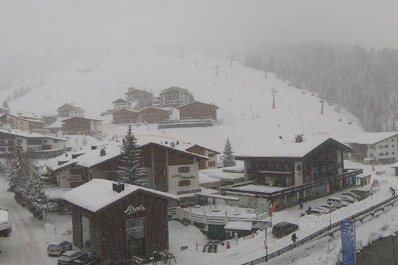 Snowing today in Lech, with lots more to come later this weekend – Photo: lechzuers.com, 20 December 2024
France
New snow has improved snow conditions across most French ski resorts although some southern resorts have missed out and any new snow is very windblown at altitude. Avoriaz (70/150cm) has already seen around 30-40cm of new snow at altitude with plenty more to come later in the weekend.
Lower down, Morzine and Les Gets will open properly tomorrow (Saturday) with better conditions than at the start of many recent seasons, with more snow to come on Sunday and Monday.
Further south, Isola 2000 only saw a dusting from this latest storm but can offer some decent if hard-packed piste-skiing on a mix of natural and artificial snow.
 Snowy all the way down to Les Gets right now – 20 December 2024 – Photo: lesgets.com
Italy
On the whole, Italian ski resorts have seen less fresh snow than those further north but there have still been some useful top-ups in places.
In the north-west, La Thuile (70/150cm) and Cervinia (35/150cm) have seen moderate dumps with more in the forecast later in the weekend.
Further east, the Alta Badia (25/65cm) also had a moderate fall yesterday, but won’t see much from the next storm due to hit more northern parts of the Alps later in the weekend.
 Not as much fresh snow right now in Bardonecchia as elsewhere in the Alps, but there is still decent piste-skiing – 20 December 2024 – Photo: bardonecchia.com
Switzerland
Most Swiss ski resorts have seen some useful new snow in the last 24 hours, heaviest in the north and west, with base depths now at 45/115cm in Mürren and lots more snow to come later in the weekend.
Further east, Davos (30/70cm) is another resort that has seen conditions improve in recent days and has significant new snow in the forecast.
In the far south-east, where snow depths have been more modest to date (relative to altitude), conditions will also continue to improve in St Moritz (20/65cm), where a moderate dump of snow is expected early next week.
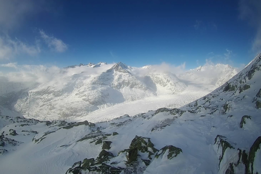 View towards the Aletsch glacier from the top of the Bettmeralp ski area – 20 December 2024 – Photo: bettmeralp.ch
Rest of Europe
Early season snow conditions are good in the Pyrenees thanks largely to one particularly potent storm earlier this month. Spain’s Baqueira Beret has settled snow depths of 35/70cm and Andorra’s Soldeu is in similar condition with 30/70cm.
There is plenty of good skiing on offer across Scandinavia, with Norway’s Hafjell (70/100cm) and Sweden’s Åre (45/70cm) two of the better bets.
Due to mild weather this week in Scotland, there is no proper lift-served skiing here until further notice.
 Good snow conditions right now in the Pyrenees. This is Cauterets – 20 December 2024 – Photo: cauterets.com
USA
Snow conditions are somewhat mixed across the western US with below par snow depths in Utah where Park City (60cm mid-mountain base) needs much more snow if it is to open more terrain before Christmas.
The situation is better in Colorado thanks to more consistent pre-season snowfalls, which mean that mid-mountain snow depths of 95cm are closer to where they should be in Vail.
In California, Mammoth (165cm upper base) continues to offer by far the greatest extent of open terrain, with 175 of its 178 trails open today.
Canada
Whistler (148cm mid-mountain base) is in excellent shape higher up, with nearly 1m of new snow in the last week and lots more to come over the next week, albeit with some rain at resort level at times.
Further inland, Sunshine has seen a more modest 30cm of new snow in the last week and has an 86cm mid-mountain base, but can also offer some good early season skiing, especially on-piste.
 Snow conditions at altitude in Whistler are as good as anywhere in North America right now – 20 December 2024 – Photo: facebook.com/WhistlerBlackcomb
Our next full snow report will be on
Friday 27 December 2024
