


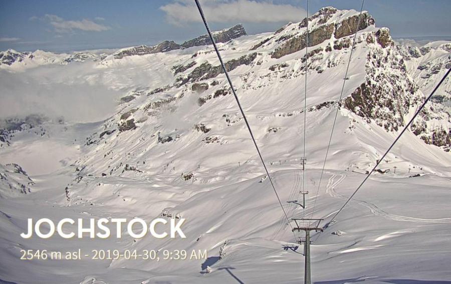
Updated: 9.00am Tuesday 30 April 2019 – Winter is still going strong in the Alps!
Since we last reported on Saturday there has been plenty of new snow in the Alps, especially in Switzerland and Austria. Over the next couple of days it will warm up again across the Alps, but another wintry blast is expected later this week, with snow likely to 1000m again in some northern and eastern parts of the Alps this weekend.
 Winter is still going strong in Engelberg – 30 April 2019 – Photo: titlis.ch
The heaviest snow over the last few days fell in both Austria and some central/northern parts of Switzerland. As a result all of the Austrian glaciers are now in great shape. Stubai, for example, saw 30cm of new snow in the last 24 hours and has a very impressive base depth of 600cm. Some big name non-glacial resorts such as Ischgl and Obertauern are also open, though both of these will finally end their excellent seasons tomorrow (1 May).
In central/northern Switzerland, the Titlis glacier above Engelberg has seen close to 1m of new snow over the last week or so. The base depth here is a massive 780cm - probably the deepest in the world right now. A number of other resorts are also still open in Switzerland, including Zermatt, where you can ski in the Klein Matterhorn area all year round.
Some eastern Italian resorts, notably the Dolomites, have also seen significant snow in recent days although most resorts here are now closed. One exception is Cortina where a handful of runs will stay open until tomorrow (1 May). Further west in Italy your best bet is Cervinia, which has seen less fresh snow but where a much larger selection of runs will remain open until 5 May.
There are also a handful of resorts still open in France, although recent snow showers here have generally been lighter. Val d’Isère closes tomorrow (1 May), while Tignes and Val Thorens continue until Sunday 5 May.
As for the weather in the Alps, snow flurries will continue in Austria today, especially in the eastern Austrian Alps. The southern and western Alps will, by contrast, see plenty of sunshine.
After a largely fine day on Wednesday, the weather will deteriorate again from the north on Thursday with further snow at times for the northern Alps until Sunday, with the heaviest falls on Saturday. The rain/snow limit will start at around 1800-2000m but will drop to 1000m or lower in places by the weekend.
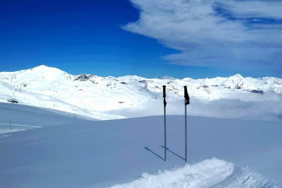
Updated: 11.00am Saturday 27 April 2019 – Excellent late season snow conditions at altitude…
The weather in the Alps remains cool and changeable, with further snow in the forecast, especially in the north.
 Fabulous late season snow conditions in Val Thorens yesterday – 26 April 2019 – Photo: facebook.com/Valerie.Suchet
We have already seen a lot of snow at altitude this week in both the southern Alps and close to the main Alpine borders, in areas such as Zermatt, Saas-Fee, Cervinia, Monte Rosa and Andermatt. Yesterday, a cold front introduced even colder air from the north-west with snow falling to 1000m in some western parts of the Alps.
This cool and unsettled theme will continue over the next few days although most of the snow will fall in the northern half of the Alps, with a rain/snow limit between 1000m and 1500m, but perhaps even lower in places on Sunday.
Open resorts which should benefit from snow showers this weekend, especially tonight and tomorrow, include Engelberg, Sölden, Obergurgl, Obertauern and Kaprun. The western Swiss Alps (e.g. Zermatt) and northern French Alps (e.g. Tignes) may also see some flurries, but the snow will not fall as heavily as it will further east. The southern Alps will generally be drier, especially away from the high border areas.
Snow conditions in the Alps are very good for late April even if only a handful of (mostly high) resorts remain open.
If you are planning on skiing in the Alps next week, some of the better options include Tignes, Val Thorens, Zermatt and Cervinia, or some of the Austrian glaciers (e.g. Hintertux, Stubai, Kitzsteinhorn), all of which will be open all week.
Updated: 10.00am Friday 26 April 2019 – Return to winter for some…
The weather in the Alps remains very unsettled with significant new snow for some, especially close to the Swiss-Italian border, with over 1m of new snow having already fallen at altitude in parts of the southern Swiss and western Italian Alps (e.g. Monte Rosa region).
 Heavy snow above Zermatt this morning – 26 April 2019 – Photo: zermatt.ch
Further snow is expected today across some southern and western parts of the Alps, with the heaviest falls this morning being close to the high border regions between Italy and Switzerland (roughly in a triangle between Zermatt/Cervinia up to Andermatt and back down towards St Moritz). The rain/snow limit will fall from around 1600-1800m to 1000-1400m later today.
The weather will remain changeable over the weekend with further snow in places, especially in the northern half of the Alps where it could fall to as low as 1000-1300m at times. The southern Alps should, by contrast, stay mostly dry with more in the way of sunshine, especially away from the high border areas.
Next week, the weather will start changeable with some showers (snow to 1200m) in the eastern Alps, notably in Austria. It should be drier and brighter further south and west, settling down in all areas (at least for a time) mid-week.
Only a handful of Alpine resorts remain open for skiing, with more due to close this weekend or early next week. This weekend, given that the forecast is better for the southern Alps, a good bet could be Italy’s Livigno, part of which will actually remain open until 5 May.
However, if you are planning to ski next week the best options may be Tignes, Val Thorens and Zermatt/Cervinia. Most of the Austrian glaciers (e.g. Hintertux) will also be open, though the weather will be less inviting here early in the week.
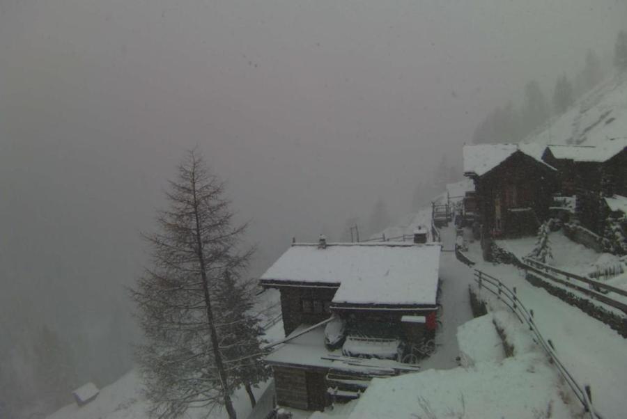
Updated: 4.00pm Thursday 25 April 2019 – Very unsettled, with snow for some…
The weather in the Alps is in a very unsettled mood right now. Over the last few days we have seen a mild southerly airflow which has brought snow to higher parts of the central and southern Alps including Zermatt, Saas-Fee and Monte Rosa, but there has also been lots of snow staining Saharan dust, and rain lower down.
 A rather stormy looking Tignes, where some snow is expected over the next few days – 25 April 2019 – Photo: tignes.net
By contrast, a strong Foehn wind has kept things mostly dry and warm but very windy in the northern Alps (e.g. the Jungfrau region in Switzerland, and Salzburgland in Austria).
Today, a new weather front embedded in this strong southerly airflow is approaching the Alps from the west. It will deliver further heavy snow to some western and southern parts of the Alps, especially the high border areas between France and Italy, Italy and Switzerland and eventually Italy and Austria. Open resorts that should see significant snow from this latest storm include Zermatt, Saas-Fee and the Monte Rosa region.
The weather will remain very unsettled on Friday and Saturday but the wind will gradually turn into the north-west. This will have the twin effect of shifting the heaviest snow into the northern and western Alps, and bringing the rain/snow level down, eventually to 1000m or lower.
Later in the weekend and early next week the weather will improve, first for the southern Alps then across all areas by Tuesday/Wednesday, with the north-eastern Alps seeing the improvement last.
In terms of snow conditions in the Alps, it is a complicated picture to say the least. This weekend won’t be great in terms of weather and visibility, not helped by the fact that the few ski areas still open are mostly high and above the tree-line, although some southern resorts (e.g. Livigno) may see some sun, especially on Saturday.
Resorts that remain open all of next week (when the weather should be better) include Val d’Isère/Tignes, Val Thorens, Zermatt, Cervinia and Hintertux. There are others of course but these are among the best options in terms of both snow conditions and the extent and variety of terrain available.
Updated: 4.00pm Wednesday 17 April 2019 – Back to full spring mode…
Weathertoski is currently in Tignes and skiing with Snoworks. Today was much sunnier than yesterday and, with afternoon freezing levels at around 2600m, meaning that the freeze-thaw cycle was much more pronounced. For the snow to stay firm and grippy all day long, you would have to have been on north-facing slopes above about 2500m.
 Great spring skiing today in Tignes – 17 April 2019 – Photo: weathertoski.co.uk
Elsewhere in the Alps there has also been plenty of sun today with just the odd very isolated afternoon shower here and there set off by the heat. There will be no major change in the weather in the Alps over the next couple of days, with most areas seeing plenty of warm sunshine, but there will be a few scattered afternoon showers here and there, most likely close to or just to the south of the high border areas between France and Italy.
Snow conditions here in Tignes remain pretty good for mid-April, but after a chilly start to the week, the daily freeze-thaw process is becoming more and more pronounced again as temperatures rise.
If you are still thinking of squeezing some skiing in this season, there are probably only a few resorts that you might still want to consider - Tignes and Val d’Isère being chief among them. Other recommendations include Val Thorens, Cervinia, Zermatt, Obergurgl and Hintertux, but note that it will still become increasingly hard to find snow that stays firm and wintry all day long even in these resorts (all of which top 3000m).
Updated: 5.30pm Tuesday 16 April 2019 – Dusting of new snow for some western parts of the Alps…
Weathertoski is currently in Tignes and skiing with Snoworks. After a bright start this morning, the weather turned cloudy, with some very light snow above 1800m this afternoon, but no measurable accumulations.
 Good snow cover still down to Tignes Les Brevières (1550m) – 16 April 2019 – Photo: weathertoski.co.uk
Elsewhere in the Alps, there has been patchy light snow today in some other western regions, notably in France and Switzerland, but any accumulations have been negligible.
Wednesday will see a return to relative sunny weather right across the Alps. It will also be warmer with freezing levels approaching 3000m in some western regions, which might just be enough to set off the odd isolated afternoon shower. It will turn warmer still on Thursday and Friday with plenty of sunshine again for most but an increasing risk of afternoon showers (snow 2500m), especially in the west on Friday.
Snow conditions here in Tignes remain pretty good for mid-April, but after a chilly start to the week, the daily freeze-thaw process is becoming more pronounced again as temperatures rise.
If you are still thinking of squeezing some skiing in this season, there are probably only a few resorts that you might still want to consider - Tignes being chief among them. Other recommendations include Val Thorens, Cervinia, Zermatt, Obergurgl and Hintertux, but note that it will still become increasingly hard to find snow that stays firm and wintry all day long even in these resorts (all of which top 3000m).
Updated: 2.30pm Monday 15 April 2019 - Great skiing still at altitude in the Alps…
Weathertoski is currently in Tignes and skiing with Snoworks. The weather has been fine here today, even if a few ‘fair weather’ clouds have obscured the sun from time to time this afternoon. Temperatures were a little higher today than at the weekend but, with freezing levels still struggling to get much above 2000m, it continues to feel chilly at altitude.
 Great snow and weather conditions here in Tignes this morning – 15 April 2019 – Photo: weathertoski.co.uk
A weather front is set to bring a little light snow above about 1600-1800m to the western Alps (chiefly France and western Switzerland) tomorrow, however, most regions will stay dry with the best of any sunshine in the eastern Alps. Wednesday and Thursday should then be mostly fine and relatively mild for all regions.
Snow conditions here in Tignes are very good for mid-April. On Saturday and Sunday the snow remained firm and grippy all day long on north-facing slopes, even those close to resort level. However, with rising temperatures, the freeze-thaw process is now accelerating again, though snow cover remains excellent and there might even be a little top-up on Tuesday.
On the whole, snow cover is generally better in the northern half of the Alps than in the south, where you now have to be very high for it to look anything like winter.
Updated: 5pm Friday 12 April 2019 - Chilly but turning warmer next week…
The weather in the Alps is relatively chilly for April and will turn colder still this weekend before temperatures rise again next week. There will be a few flurries here and there over the next few days, but significant widespread snow is not expected, and many places will stay dry.
 Relatively cold in Zermatt right now but warming up again next week – 12 April 2019 – Photo: zermatt.ch
Some resorts have now closed, but, thanks to the cool weather those still open are generally offering good snow conditions for the time of year. Snow cover is most complete in the central and northern Alps, but patchier in the southern Alps where you have to be very high (e.g. Cervinia) for it to still look anything like winter.
If you are still thinking about skiing in the Alps over the next week, you might want to consider the following resorts:
- France - Val d’Isère, Val Thorens, Arc 2000 and La Plagne.
- Switzerland - Zermatt, Saas-Fee, Verbier, Engelberg and Andermatt.
- Italy – Cervinia and Livigno.
- Austria - Obergurgl, Sölden and Ischgl
There are plenty of others of course but these resorts are as good as any.
As for the weather next week, Sunday will see the peak of the cold, and it will become steadily warmer as the week goes on, most noticeably in the west. Many places will be dry, but there could be dusting of high-altitude snow in places, especially in the first half of the week.
Updated: 11am Wednesday 10 April 2019 - Chilly for April…
The weather in the Alps is currently on the cool side for the time of year. There will be some flurries here and there over the next few days, especially in the eastern Alps, although widespread heavy snow is not expected.
 Good snow cover in the northern Alps, even at quite low altitudes. This is Les Saisies – 10 April 2019 – Photo: lessaisies.com
Many places will start dry today, although there are already snow showers this morning across parts of Austria and eastern Switzerland (snow 1500-1700m), and scattered showers will also tend to pop up further west as the day goes on. However, any showers will always be more widespread across the eastern Alps where up to 5-10cm is possible at altitude in a few favoured locations. By contrast, some western parts of the Alps will stay completely dry all day.
The temperature will start to fall on Thursday, especially across the northern and eastern Alps where the rain/snow limit in any showers will fall to 1400m in places. Temperatures will fall even further towards the end of the week, with snow showers to below 1000m by Saturday.
Thanks to the relatively chilly weather, snow conditions remain pretty good for mid-April across the Alps, especially at altitude in the central/northern Alps where base depths are generally above average. Snow cover is much patchier in the southern Alps, although you can still some perfectly decent piste skiing here, especially higher up.
Updated: 10.15am Monday 8 April 2019 - Snow conditions remain generally impressive for April…
In the last 24 hours we have seen a few centimetres of snow here and there across the Alps. Most of yesterday’s snow fell in the west and was generally quite light, though the high border areas between France and Italy (e.g. Glacier du Pissailas, Val d’Isère) did see up to 45cm.
 Great late season snow conditions in Avoriaz – 8 April 2019 – Photo: avoriaz.com
The western Alps will be brighter today, although the odd shower still can’t be ruled out, but the eastern Alps will be cloudier with a little light rain or snow (1400m) here and there. The rest of the week will be relatively cool (for April) with some sunny spells but also some bands of showers from time to time.
We are not expecting huge amounts of new snow over the next few days but many resorts will see at least a few centimetres over the next few days, at altitude at least. A more potent storm is possible next weekend but that is still a long way off - watch this space!
Snow conditions in the Alps are generally very good for early April. The benefit of fresh snow can be short lived at this time of year, at least lower down, but snow cover remains very good across most of the central/northern Alps. It is even exceptional in places, such as Engelberg where the base depth on the Titlis glacier is over 7m!
Updated: 10am Saturday 6 April 2019 – Another great skiing day in prospect for the Alps…
Yesterday was one of the best skiing days in the Alps this season, with lots of new snow and blue skies everywhere, apart from in the far east. Spring snow conditions have quickly returned to lower parts of the Alps, not surprising given the time of year, but conditions are still superb at altitude and should remain so over the weekend.
 Great snow conditions in the Bernese Oberland today. This is Lenk-Adelboden – 6 April 2019 – Photo: adelboden.ch
As for the weather today, it is again reasonably fine across most parts, though there is quite a lot of high cloud around (especially in the west) ahead of the next, albeit much weaker, storm currently approaching the Alps.
This new storm will give a few centimetres of snow here and there both tonight and early tomorrow across the French Alps, western Italian Alps, and southern and western Swiss Alps, before it moves on to Austria and the eastern Italian Alps on Monday and Tuesday. Wherever you are though, do not expect huge amounts of new snow.
Updated: 10am Thursday 4 April 2019 - Significant snow for many parts of the Alps…
The much anticipated storm has now hit the Alps, with many (but certainly not all) areas seeing significant snow. As forecast, the heaviest snow is falling close to the Swiss-Italian border, roughly to the east of Zermatt and as far north as Andermatt.
 Snowing heavily in southern Switzerland this morning. This is Obergoms – 4 April 2019 – Photo: astoria-obergoms.ch
Indeed, since yesterday we have already seen snowfall totals of 80-100cm high above Zermatt-Cervinia, especially on the eastern side of the ski area and through the Monte Rosa Region. We have also seen 90cm reported close to Andermatt.
Across the western Alps more generally, there have been significant but not exceptional snowfalls in the last 24 hours – with, for example, 30cm up top in Flaine, and 45cm in the eastern Bernese Oberland and on the Titlis glacier above Engelberg.
The southern French Alps have also done pretty well with 20-50cm at altitude (with 80cm locally to the west of the Écrins) but snowfall totals in the mega resorts of the Tarentaise have so far been a bit disappointing. They will see a little more snow today, but snowfalls totals in the likes of Val d’Isère, Les Arcs and Méribel have so far been closer to 10-25cm.
It will continue to snow for a while today in the central and western Alps before it becomes drier in the far west later in the day. Meanwhile, the heaviest snow will continue to move slowly east through Switzerland and Italy, and eventually into Austria, with resorts such as Passo Tonale (western Dolomites) and Obergurgl (south-west Austria) also getting some big falls. The least snow will fall in the northern and north-eastern Austrian Alps (e.g. Salzburg area).
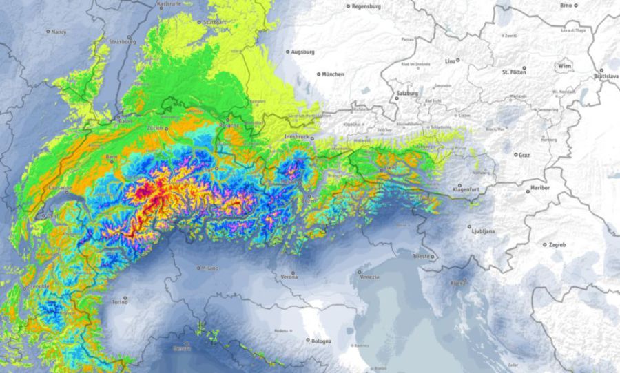
Updated: 10am Wednesday 3 April 2019 - Snow Sandwich!
The weather in the Alps is deteriorating, even though it will take until tonight or tomorrow for some areas protected by the Foehn to see the main band of precipitation.
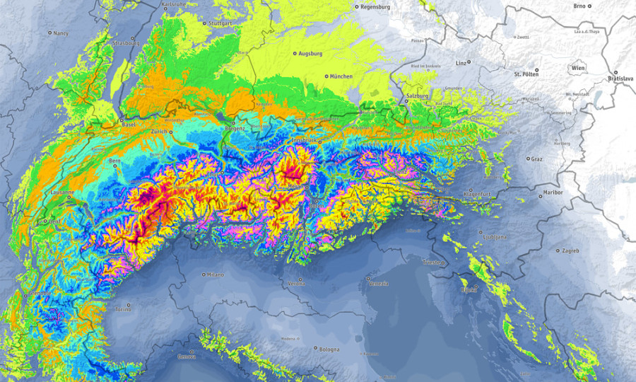 Forecast snowfall totals between now and Friday morning, with reds and purples showing possible accumulations of 1m or more – Image: bergfex.com, 3 April 2019
It is already snowing (roughly above 1400m) this morning along the high border areas between Switzerland and Italy, as it has been for much of the night. Elsewhere in the Alps there is a scattering of showers, but many places are still dry, if rather cloudy, with the best of any sunshine in the north-eastern Austrian Alps. Thanks to the Foehn, there will also be some sunny spells this morning in the more internal valleys of the northern French and central/northern Swiss Alps.
Later today, something of a “Snow Sandwich” will develop across the Alps. The southerly airflow ahead of the main storm will continue to produce snow close to the border regions between Italy and Switzerland, with this area of precipitation tending to intensify and expand this evening and overnight. At the same time the main weather fronts to the west of the Alps will move slowly east, reaching the French and western Swiss Alps tonight, but earlier in the western foothills.
Everything is set to meet up tonight bringing heavy snow to the western Alps. This will move further east to reach the western Austrian Alps by Thursday morning. Later on Thursday/Thursday night the band of precipitation will finally cross most of Austria, although it will be weakening by then.
The rain/snow limit will be highly variable during this storm. In the western Alps it will typically start today at around 1300-1600m but will lower dramatically tonight, dropping to 500-700m tomorrow. Further east, the rain/snow limit will start at around 1400-2000m tonight, but will take longer to lower, eventually lowering to around 1000m on Thursday night.
The greatest snowfall totals from this storm will be close the Swiss-Italian border, roughly to the east of Zermatt (including resorts such as Saas-Fee, Cervinia, the Monte Rosa Region, the Aletsch Arena and the smaller resorts of Ticino). By the end of Thursday some of these areas could see over 1m of new snow at altitude, with 1.5m in places, though it should be stressed that there won’t be anything like this amount at resort level.
The central and south-eastern Swiss Alps (e.g. Andermatt, St Moritz) will also do very well, as will Italian resorts a little further east, such as Passo Tonale and the far south-west of Austria (e.g. Obergurgl). These areas could see 50-80cm of new snow at altitude by Thursday night.
More generally, the western Alps (including most other parts of the French and Swiss Alps) will see 20-60cm of new snow by Thursday night/Friday morning, as will the Dolomites. The far south-western Italian Alps (e.g. Sestriere) and the northern/eastern Austrian Alps (e.g. Kitzbühel) will see some snow but miss out on the heaviest precipitation.
Updated: 9.30am Tuesday 2 April 2019 - Storm incoming!
The weather in the Alps is on the change as a major storm moves in from the west. While it has been a complicated one to forecast, it does look like delivering some useful snow to many parts of the Alps (15-50cm at altitude) with some particularly big falls (1m+ in places) close to the Swiss-Italian border (roughly to the east of Zermatt and as far north as Andermatt).
 Snapshot of expected snowfall between Tuesday and Thursday this week, with the darker red areas showing potential for 1m or more of new snow – Image: bergfex.com, 2 April 2019
Back to today and there is still plenty of sun in the central and eastern Alps. By contrast, cloud is already streaming into the western and south-western Alps where a few showers (snow 1600-200m) are likely later. Many places will stay dry though.
On Wednesday there will be a more marked deterioration of the weather in the southern and western Alps, although some valleys will be protected by the Foehn and will stay dry for a good part of the day, as will much of Austria. The rain/snow limit will start at around 1300-1800m (highest in the east), lowering from the west as the day progresses. The heaviest snow will fall in the central-southern Swiss Alps later (e.g. Aletsch Arena) and more generally in areas close to the Swiss-Italian border to the east of Zermatt.
Thursday will see snow for many early in the day, even to quite low levels (400-1000m) before it dies away in the western Alps. Further east it will snow for much of the day, heaviest close to south-western Austrian-Italian border (e.g. Obergurgl, Passo Tonale) but with a higher rain/snow limit generally between 1000m and 1500m, possibly lower during the most intense precipitation. The weather will be much better across most of the Alps on Friday, though there will still be some areas of cloud around.
Throughout this period the area least likely to see any significant snow is the far north-eastern Alps (i.e. Salzburg and east).
Updated: 12pm Monday 1 April 2019 - Significant snow for many later this week...
It’s another mostly fine day for the Alps today, even if there will be some areas of high cloud turning the sunshine hazy in places, especially later in the day. It will also be reasonably mild, though not excessively warm, with freezing levels typically around 2500m.
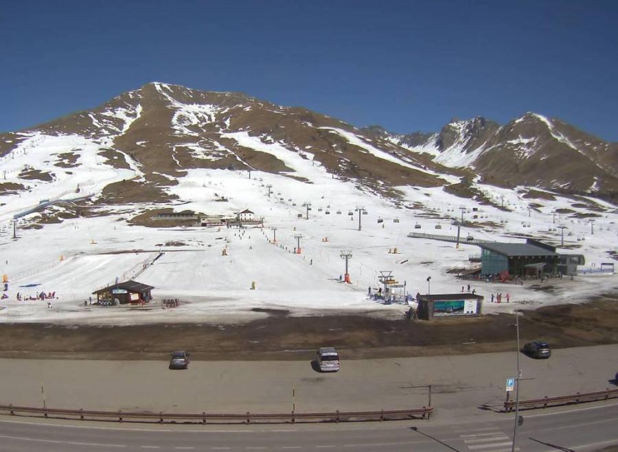 Looking very spring-like on the sunnier side of Passo Tonale today but winter is expected to return with a vengeance here mid-week – 1 April 2019 – Photo: bergfex.com
Last Friday we talked about a major change in the weather being on the cards, with a possible return to winter mid-week. While this change is still going to happen, it now looks like it will be the southern Alps that will see the most snow.
The change in the weather will start to be felt tomorrow with more in the way of cloud and some showers in the French, western Swiss and western Italian Alps later in the day, with a rain/snow limit between 1500m and 2000m.
More widespread precipitation is expected across the Alps on Wednesday and Thursday, heaviest close to the Swiss-Italian and Italian-Austrian border regions. The rain/snow limit will be highly variable depending on location but will tend to lower across the board, and many places will see snow to below 1000m on Thursday.
Snowfall totals from this upcoming storm will also be highly variable, but over 1m of new snow is possible by Friday at altitude close to the Swiss-Italian border (i.e. roughly east of Zermatt and as far north as the Loetschberg tunnel and Andermatt).
Many other parts of the Alps will also see some significant snow, though 15-50cm is the more likely range. The north-eastern Alps (e.g. Salzburg, Lower and Upper Austria, Styria) will see the least.