


ARCHIVE
Today in the Alps - December 2022
Read about current weather and snow conditions in the Alps
Updated: 9.20am Saturday 31 December 2022 – Exceptionally mild…
Following another rainy spell in the north-western Alps last night, it’s a mostly dry day today across the Alps, with sunny spells and very mild temperatures. Indeed, thanks to the Foehn effect, temperatures in some of the lower valleys of the central and northern Alps could approach 20°C.
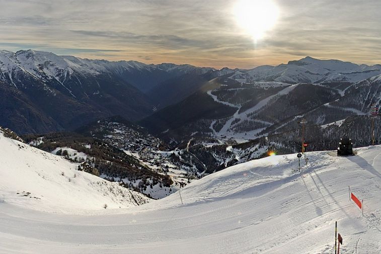 Some of the best skiing in France is in the south right now. This is Auron, not far from Nice – 31 December 2022 – Photo: auron.com
It will remain exceptionally mild across the Alps until late on Monday/Tuesday when a weak weather front will introduce cooler air and very light snow to some areas, mostly in the northern Alps. However, we will have to wait until the second week of January (at least) before there is any chance of significant widespread snow returning to the Alps.
Last night’s rain fell to 2200-2500m in the northern French Alps (e.g. Grand Massif, Portes du Soleil), with around 10-20cm of new snow above 2500m (e.g. Tignes, Chamonix). This rain event was not as pronounced or damaging as last week’s, but it did nothing to improve the lower (or even mid-range) ski areas of the north-western Alps, where natural snow cover is extremely patchy below about 1600m or so.
In short, the most consistent snow conditions are currently in the south-eastern Alps where the Dolomites, for example, have escaped all the recent rain events and continue to offer some very good piste skiing, even at lower altitudes.
On the whole, the further north-west you are the higher you have to be, with wintry snow conditions still available above 2300-2500m in resorts such as Val Thorens, Val d’Isère, Tignes, Cervinia and Zermatt. Some good piste skiing is also possible lower down in the western Alps, notably around the Serre Chevalier,
Montgenèvre and Puy St Vincent area and more generally in the southern French and south-western Italian Alps (e.g. Isola 2000, Bardonecchia).
More on this in our detailed snow report out later today…
Updated: 9.40am Friday 30 December 2022 - A little new snow for some but turning warmer again, with rain in places…
After a few centimetres of snow to around 1500m in the north-western Alps last night, it’s a dry start for many today. However, the next weather front (this time a warm one) is already rapidly approaching from the west. This will bring another spell of nuisance-value rain to some of the northern-western Alps later today, though it won’t be as intense as the infamous rain spell last week.
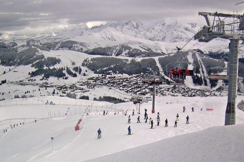 A few centimetres of snow last night have refreshed the pistes in Les Saisies, but rain is expected later today – 30 December 2022 – Photo: lessaisies.com
The bad weather will reach the northern French Alps early this afternoon, before moving further further east as the day progresses, but diminishing in intensity as it does. The rain/snow limit will start at around 1700-1900m but will rise to 2200-2500m this evening.
The worst affected resorts will again be the lower ones of the north-west, such as Megève, La Clusaz, Villars, Gstaad and the resorts of the Portes du Soleil. However, the lower parts of the higher ski areas (the 3 Valleys and Paradiski) will also be affected, with rain to as high as 2500m tonight. The further south and east you are, the less intense any precipitation will be, with only a few showers making it across the northern and western Austrian Alps. It will again stay completely dry in many central, southern and south-eastern areas (e.g. Dolomites).
As for snowfall totals, another 10-20cm of new snow is expected above 2500m in the north-western Alps, with perhaps closer to 30cm in some favoured spots (e.g. higher up in the Massif du Mont Blanc).
This new spell of rain, while shorter and less intense than last week’s, is bad news for the already struggling low resorts of the north-western Alps, where natural snow cover is already very patchy. It is also set to stay very mild over the New Year period.
In short, if you are off the Alps soon, the most consistent snow conditions will be found the further south-east you are (e.g. Dolomites) or at very high altitude in the north-western Alps (e.g. Tignes, Val Thorens), at least if you get a break in the weather.
Updated: 12pm Wednesday 28 December 2022 – Mostly fine weather, with variable snow conditions…
It’s a mostly fine day across the Alps, with plenty of sunshine albeit hazy in places. Temperatures are not excessively mild either, with freezing levels typically between 1000m and 1500m in the eastern Alps (e.g. Obertauern) and 2000m in the western Alps (e.g. Val d’Isère).
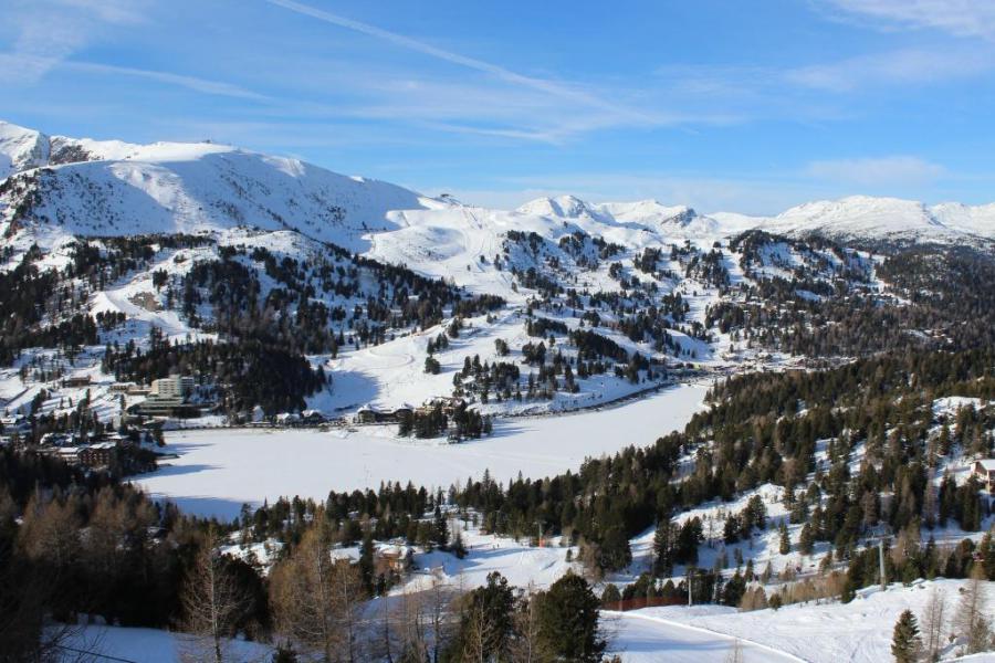 Good on-piste snow conditions in the southern Austrian Alps. This is Turracher Höhe – 28 December 2022 – Photo: foto-webcam.eu
On Thursday, a relatively weak weather front will approach from the west bringing a little snow above about 1500-1700m for parts of the French Alps, and western and northern Swiss Alps. The best of the sunshine will be found the further south and east you are. On Friday, another front will affect the western Alps, but with a rising rain/snow limit - as high as 2300m in places. This “rain event” won’t be anything like as severe as last week’s one though.
Snow conditions are highly variable across the Alps right now. The southern Alps (e.g. Isola 2000, Risoul, Bardonecchia, Madesimo, Madonna di Campiglio, Arabba), where there was less or no rain last week. are generally offering the most consistent snow conditions with some excellent on-piste skiing.
If you are currently in the north-western Alps, altitude is much more of a factor. Although resorts such as Val d’Isère, La Plagne and Val Thorens saw some rain lower down last week, they already had enough snow to “ride it out”, at least higher up. Above 2500m there was also a lot of fresh snow. Lower down, however, natural snow cover is much patchier in resorts such as Morzine, Megève, La Clusaz, Villars and Gstaad. There are still a fair number of pistes open, but snow conditions are generally poor for the time of year and much more snow is needed.
Updated: 11.30am Tuesday 27 December 2022 – A little fresh snow for the northern Alps but…
There is still some cloud and the odd flurry in the north-eastern Alps today, otherwise it’s a mostly fine day with the best of the sunshine the further south and west you are.
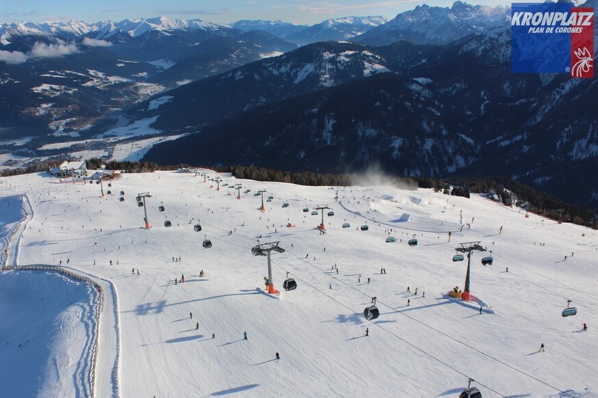 One of the few areas where you don’t need to be high to find good piste skiing right now is the Dolomites. This is Kronplatz – 27 December 2022 – Photo: kronplatz.com
Last night saw some fresh snow in the northern Alps, generally in very modest quantities with about 5cm in Val Thorens, and 10-15cm across the higher parts of the Arlberg (e.g. Zurs). Another dusting is possible on Thursday at altitude across the north-western Alps, otherwise there is no significant widespread fresh snow in sight for the Alps. Indeed, the first week in January is likely to be mild and mostly sunny.
Snow conditions are generally below par for late December, especially lower down in the north-western Alps where a lot of rain fell last week. An amazing job is being done to keep a decent number of pistes open in the likes of Megève, Morzine/Les Gets and La Clusaz, but this can’t disguise the fact that natural snow is now very patchy lower down.
For the best snow conditions right now, you need to either much further south-east (in resorts in the Dolomites such as Selva, Cortina, Arabba, which avoided the recent rain) or very high (in the likes of Val d’Isere, Tignes, Val Thorens, Cervinia and Zermatt). Note though that the risk of avalanche off-piste remains high!
Updated: 11.30am Saturday 24 December 2022 – The worst of the rain is over, but it remains mild…
The worst of the rain is now over in the north-western Alps, though there is still some residual precipitation in places, chiefly in the northern Swiss and western Austrian Alps. With the influx of some slightly cooler air, the rain/snow limit has also lowered a bit, especially in Austria where it was snowing down to 1400m or so in the Arlberg region this morning, for example.
 A lot of the lower-lying snow has been washed away in the lower regions of the north-western Alps – 24 December 2022 – Photo: lesgets.com
Sunday should be mostly fine but still quite mild across most of the Alps. On Monday, many places will continue dry with sunny spells though new, relatively weak, weather fronts will arrive in the north-western Alps later in the day with some rain or snow (1500-1800m) in places.
Snow conditions have seriously deteriorated across the north-western Alps following the recent intense rainfall. The worst of the rain fell across the northern French Alps where most of the natural (unmanaged) snow has disappeared below about 1400m or so. This includes the likes of the 3 Valleys, the Grand Massif, the Chamonix valley and the Portes du Soleil. The western and northern Swiss Alps (e.g. Villars, Gstaad, Jungfrau region) have also been badly affected. Austria also saw rain, especially in the west (e.g. Arlberg region) but the loss of snow has not been quite as acute here as it was further west.
This storm also brought 50-80cm of fresh snow above 2500m across most of the northern French Alps, the western and northern Swiss Alps, and western Austria, with over 100cm in some prone spots, including areas close to the Massif du Mont Blanc.
The areas that have avoided the rain completely are further south-east, including the Dolomites, where good on-piste conditions have continued throughout this week.
Updated: 6am Friday 23 December 2022 - Washout in the north-western Alps!
There is a very difficult day ahead across the north-western Alps with a lot of rain at low and medium altitudes, and a lot of snow (and wind) higher up.
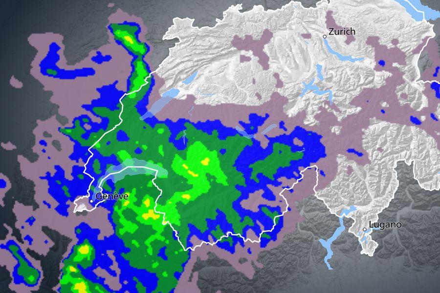 Radar snapshot from early this morning showing the heaviest precipitation falling across the northern French and western Swiss Alps – Image: meteosuisse.ch, 23 December 2022
Very roughly speaking, the areas that will see the most persistent rain/snow today will be the northern French Alps (north of Alpe d’Huez), much of the Swiss Alps (away from the far south and south-east - i.e. not Ticino or the Engadin), and the far west of Austria (e.g. Arlberg).
The very heaviest precipitation will be reserved for the northern French Alps, including the likes of L’Espace Killy, the 3 Valleys, the Paradiski, the Mont Blanc area, the Grand Massif and the Portes du Soleil. These areas can expect a complete wash-out at lower altitudes today, with a rain/snow limit around 2300-2400m. By contrast, snowfall totals above 2500m between Thursday evening and Saturday morning could be in the region of 50-80cm, with over 1m possible close to the Massif du Mont Blanc!
It will also be very wet across the northern and western Swiss Alps, including resorts such as Villars, Verbier, Gstaad, the Jungfrau region and Engelberg. The further east and south-east you are, though, the less intense and persistent the rain/snow will be. Zermatt, for example, will still be quite wet today lower down, but not as wet as in the far western Swiss Alps (e.g. Villars). St Moritz, by contrast, will only see very light and patchy precipitation.
The western and northern Austrian Alps (e.g. Lech, Kitzbühel) will also see some rain today though it will quickly become lighter and patchier the further south you are, with only light and patchy precipitation in Obergurgl and nothing in the far south (e.g. Nassfeld).
In Italy, rain (and snow at high altitude) will affect the far north-west (e.g. Courmayeur, La Thuile) but will become less of an issue the further south and east you are, with the Dolomites remaining mostly dry.
Needless to say, snow conditions are going to deteriorate significantly at lower and medium altitudes across a wide swathe of the north-western Alps. The best place to be at the moment is in the far south-eastern Alps (e.g. Dolomites).
We will publish a full and detailed country by country snow report later today…
Updated: 1pm Thursday 22 December 2022 – Lots of rain for the north-western Alps!
The Alps are under the influence of a humid but very mild westerly airflow which will bring a lot of rain to some areas over the next few days, mostly in the north-west.
 Increasingly rainy weather expected in the north-western Alps over the next few days. This is Châtel – Photo: chatel.com, 22 December 2022
Today there are just a few showers across the northern alps with a rain/snow limit around 1600-1800m. The further south you are, the better the weather, with a good deal of sunshine across the Italian Alps, for example.
Things get tricky tonight, though, as an active warm front arrives from the west. This will bring a lot of rain to the north-western Alps and a lot of snow (and wind) at high altitude. The rain/snow limit will rise towards 2300m, though it will stay lower for a while in the more internal valleys (e.g. Val d’Anniviers) where the cooler air takes longer to get displaced.
The heavy rain/snow will continue throughout tomorrow and into Friday night, by which time the lower resorts of the north-western Alps will have received a lot of snow. Resorts that are going to be particularly affected include (but are not limited to) the likes of La Clusaz, Megève, Morzine, Les Gets and the Portes du Soleil in general, Villars, Gstaad, Grindelwald, Wengen and Adelboden.
Higher resorts in the north-western Alps, or resorts with higher ski areas, such as those in the Tarentaise (3 Valleys, Paradiski, L’Espace Killy), Chamonix and Verbier, will also see plenty of rain lower down but significant snow higher up too. Chamonix, Glacier 3000 and Mürren, for example, may see 50-60cm above 2500m by Saturday morning, with possibly as much as 75cm at 3000m in the Chamonix area.
As is typical with warm front rain events, the further south-east you are in the Alps, the less of a problem it will be. Some rain (and high-altitude snow) will reach the northern Austrian Alps (especially the Arlberg), and a little bit of rain might (below 2200m) might even reach the very “intra-alpine” resorts of St Moritz and Obergurgl, but it will not fall in significant quantities.
The best place to be over the next few days – i.e. with no rain and some sunshine – will be the far south-east (e.g. the Dolomites).
Updated: 9.40am Wednesday 21 December 2022 – Mild and mostly cloudy, with rain or snow in places…
The Alps are currently under the influence of a mild south-westerly airstream with lots of cloud across the Alps today, with some showers, chiefly across the western Alps (e.g. France) with a rain/snow limit of around 1800m.
 Lots of cloud across the Alps today with rain or snow in places, mostly in the north-west including here in Les Saisies – 21 December 2022 – Photo: lessaisies.com
Around 5-10cm of fresh snow is expected above 2000m in the north-western Alps today (e.g. Chamonix), with less the further south and east you are. The Dolomites, for example, will be mostly cloudy but should stay dry.
Over the next few days, the weather will remain mild and changeable with further weather fronts, mostly affecting the north-western Alps. Unfortunately, this means there will be quite a lot of rain to 2000m, and even 2500m later in the week in areas such as Megève, the Portes du Soleil, Gstaad, Villars, the Jungfrau region and even the Austrian Arlberg.
Significant snow will fall at high, with as much as 50-60cm above 2500m in the likes of Chamonix and Glacier 2000, and maybe 20-40cm in Tignes, Val d’Isère and Val Thorens. However, the benefits of this high-level snow will be very limited.
All in all, this is not great news for the Alps as we head into the busy Christmas period, with deteriorating snow conditions at low and medium altitudes, especially in the north-western Alps.
For the best snow conditions over the next few days you will need to be as high and as east-south-east as possible (e.g. Obergurgl, Livigno) where it should stay mostly dry.
Updated: 11am Monday 19 December 2022 – It’s turning warmer in the Alps…
After a cold and mostly fine weekend, it has turned much milder in the Alps today and will remain on the mild side all week.
 Typical Alpine weather with mid- to high-level cloud today in Madonna di Campiglio – 19 December 2022 – Photo: funiviecampiglio.it
Today will be dry but with a lot of high cloud around and just a few sunny breaks here and there. It will be much milder than of late, with freezing levels above 3000m in the western and northern Alps.
After another very mild day tomorrow, a weak cold front will reach the north-western Alps mid-week introducing some slightly cooler weather and a few showers, mostly in the northern French and northern Swiss Alps. However, significant snow is not expected, with only a few centimetres set to fall above 1800m in resorts such as Tignes, Avoriaz and Mürren.
Later in the week (probably on Thursday night) we are expecting a warm front to arrive from the west sending freezing levels upwards again. There is also likely to be some nuisance rain below 2500m, mostly in the north-western Alps, although details are yet to be confirmed. Watch this space…
Snow depths in the Alps are generally below par for mid-December, though there is still plenty of good piste skiing to be had, particularly at altitude. The good news is that, at this time of year, the sun is weak and so has little direct effect on the quality of snow. The biggest issue early in the season is high temperatures combined with high humidity, something that will be more of a concern towards the end of the week.
Updated: 9.20am Tuesday 13 December 2022 – More snow, mostly in the western Alps…
Some of the western Alps are waking up to fresh snow this morning, with the heaviest falls in the middle two thirds of the French Alps, i.e. the departments of Savoie (e.g. Val d’Isère), Isère (e.g. Les 2 Alpes) and Haute Alpes (e.g. Serre Chevalier). These regions have seen around 15-25cm of snow already with more to come this morning. Val d’Isère, for instance, could see close to 40cm by the middle of today.
 Significant new snow in Val d’Isère this morning – 13 December 2022 – Photo: radiovaldisere.com
The Haute Savoie (e.g. Avoriaz) and the far southern French Alps (e.g. Isola 2000 in the Alpes Maritimes) also have fresh snow but in lesser quantities. Elsewhere in the Alps, the southern Piedmont (e.g. Sestriere) has also seen significant new snow but, with the front having stalled over the far western/south-western Alps, most other regions have seen little if any snow from this latest storm.
The rain/snow limit in this storm started low but is now rising and will level out somewhere between 1200m and 1600m today. The best of today’s weather will be found the further north-east you are (i.e. Austria).
Tomorrow will be mostly dry but often rather cloudy with a few flurries possible close to the northern fringes of the Alps, though they will not amount to much. Snow may return to the southern half of the Alps on Thursday, spreading a bit further north later in the day, but there is still lots of uncertainty of the fine detail. Stay tuned…
Snow conditions in the Alps are generally pretty good now for mid-December just about everywhere, with lots of good skiing at altitude, weather-permitting. There is also plenty of good piste skiing on offer lower down, but care should be taken off-piste at all altitudes as depths remain relatively modest.
Updated: 11.45am Monday 12 December 2022 - Cold but turning milder as the week progresses…
It’s a mostly sunny but very cold start to the week, with temperatures falling well below -20°C in some internal Alpine valleys first thing this morning.
 Cold and crisp in the Austrian Vorarlberg today. This is Schröcken – 12 December 2022 – Photo: warth-schroecken.at
The weather is expected to deteriorate in the western Alps tonight, with some snow in places, chiefly in the French and western Swiss Alps, continuing at times tomorrow. The rain/snow limit will start low but slowly rise towards 1500m. The central and eastern Alps (e.g. Austria) will stay mostly dry.
There is a lot of uncertainty over how much snow this new storm will produce, but 10-20cm of new snow is possible above 1500m in resorts such as Alpe d’Huez, Val d’Isère and Avoriaz, maybe even more.
Wednesday will remain unsettled but mild in the western Alps, with some showers and a bit of snow above 1800m or so. On Thursday it should then be the southern Alps that sees most of the snow, especially in the Dolomites.
Right now, snow conditions are very good across most of the Alps, with sunny skies and cold temperatures. However, with temperatures expected to rise over the coming days, snow conditions will become more variable, especially mid-week, at lower altitudes and in the western Alps.
Updated: 12.40pm Friday 9 December 2022 – More snow for most areas over the coming days!
A new set of weather fronts arrived from the west last night which are delivering further snow to many parts of the Alps today.
 Snowing to resort level in Les Gets today – 9 December 2022 – Photo: lesgets.com
In the short term, the area that will benefit most from this new storm is the French Alps, with 24-hour snowfall totals (to midnight tonight) likely to be in the 15-30cm range for most resorts, above 2000m at least. Just about everywhere will then get in on the action as the storm moves east, with many southern parts of the Alps seeing a decent fall of snow today. However, with the wind turning more northerly tomorrow, the weather will clear up in the south-west (e.g. Milky Way) and it will be the northern and especially north-eastern Alps (Austria) that will see the most snow over the weekend.
The rain/snow limit is a bit all over the place today – still above 1000m in places but much lower in some central valleys – but it will descend everywhere over the weekend, with any snow falling to just about all skiing levels by the end of Saturday.
Storm totals between the start of the storm last night and the end of Saturday are expected to be in the region of 10-25cm at 2000m across a good portion of the Alps, with 30-40cm in favoured spots such as the far northern French Alps (e.g. Avoriaz).
Next week will see some quieter but cold weather conditions for most of the Alps, with the possibility of more snow arriving from the west mid-week. The weather models remain volatile but currently indicate that the western Alps will be most favoured.
Snow conditions in the Alps are generally good for early December and improving all the time. Snow depths are still quite modest lower down, though they are in currently being or will soon be topped up. All in all, it is promising start to the season as we approach the all-important Christmas and New Year period…
Updated: 12.30pm Wednesday 7 December 2022 – Good on-piste skiing, more snow for some over the next few days...
It’s a mostly dry day in the Alps today, with variable cloud cover and the best of any sunshine at altitude in the west.
 Reasonable on-piste snow-cover for early December in Lech – 7 December 2022 – Photo: lechzuers.com
Some weather fronts will approach the Alps from the south-west later tomorrow, moving further east on Friday. These fronts will bring a bit more snow to many areas, especially in the south, with a rain/snow limit between 1000m and 1500m. It will then turn colder over the weekend, with further snow flurries to increasingly low levels, mostly in the north and east (especially in Austria).
Snow conditions in the Alps are generally quite good at altitude for the time year, even if snow depths are unremarkable. Lower down the picture is more mixed. The Dolomites, for example, are skiing well thanks to recent snowfalls and world-class snowmaking, however, natural snow cover in the Alps is very thin below 1500-1800m.
Updated: 12pm Monday 5 December 2022 - Continually improving snow conditions in the Alps…
There is an east/west split in the weather in the Alps today, with snow showers continuing across much of the eastern Alps (e.g Austria, Dolomites) but mostly sunny skies further west (e.g. France).
 Isola 2000 (near Nice) did particularly well for snow over the weekend – Photo: isola2000.com, 5 December 2022
This follows a mixed weekend of weather in the Alps which has seen fresh snow in places, mostly in the south-western Alps where the likes of Saas-Fee, Cervinia, Monte Rosa and Bardonecchia all did well, with as much as 30-50cm falling in the far south west (e.g. Isola 2000). Most of the rest of the Alps only saw a few centimetres of new snow, at best.
Snow conditions in the Alps continue to improve with lots of good piste skiing on offer at altitude (and, in places, lower down). In general though, snow depths are nothing out of the ordinary and in most cases still a bit under par for early December, especially at lower altitudes.
The relatively cool weather in recent days has allowed for plenty of snowmaking though, and it will remain quite cold over the coming days, possibly turning very cold next weekend. So, all in all, there is plenty to be optimistic about if you have an early season skiing trip booked to the Alps!
Updated: 11.45am Saturday 3 December 2022 - Val d’Isère has opened today!
A week after its scheduled opening, Val d’Isère is finally up and running today. It’s cloudy and there is some light snow in the air, but conditions are pretty good all things considered –if you can handle the variable visibility at least.
 Visibility may not be great but Val d’Isère is now open with decent snow cover top to bottom – 3 December 2022 – Photo: valdIsere.com
Today’s snow in Val d’Isère is a spill-over from a Mediterranean storm which will bring significant snow to much of the south-western Alps this weekend, especially the far southern French Alps (e.g. Isola 2000), the far southern Piedmont (e.g. Prato Nevoso), the northern Piedmont (e.g. Alagna) and the eastern Aosta (e.g. Cevinia, Champoluc). These regions could see 30-50cm of new snow by the end of the weekend.
Over the border in southern Switzerland, Zermatt and Saas-Fee might also do quite well but, on the whole, you are less likely to see any snow this weekend the further north and east you are. Engelberg, Klosters, St Anton and Kitzbühel, for example, are not expected to see any snow.
Snow conditions in the Alps are generally quite good for early December even if snow depths are mostly below par. At least 100 resorts in the Alps are at least partially open today, with the more extensive options including the Dolomitisuperski area (e.g. Alta Badia, Val Gardena) where 201 of 450 lifts are open, Ischgl (with 124km of pistes open), and Val d’Isère/Tignes (with 40 slopes open).
Updated: 10am Friday 2 December 2022 - Snow for the south-western Alps this weekend…
The weather is highly variable across the Alps today. The eastern Alps are generally cloudy with a few light snow flurries, heaviest in the south-east (Dolomites), with a rain/snow limit between 800m and 1200m. The western Alps are brighter with some sunny spells, especially at altitude in the French and western Swiss Alps.
 Sunny skies and decent on-piste snow cover in Val d’Isère today ahead of its grand opening tomorrow – Photo: valdisere.com, 2 December 2022
Over the weekend some more significant snow will fall in the south-western Alps, especially in the far southern French Alps (e.g. Isola 2000), the Piedmont (e.g. Sestriere, Alagna) and the eastern Aosta (e.g Champoluc) which are likely to see 20-30cm of new snow by the end of the weekend, and 30cm+ in places.
Val d’Isère and Tignes may also see some significant snowfall due to the “Retour d’Est” effect. The northern and eastern Alps will generally see little if any snow, with variable cloud cover and some sunny spells.
Snow levels are generally below average for early December but there is still lots of good piste skiing on offer across the Alps, with more and more resorts opening all the time. The biggest name to open this weekend is Val d’Isère, a week later than scheduled, though recent storms mean that there is now plenty of snow to ensure a good number of pistes will be open, including all the way down to resort.