


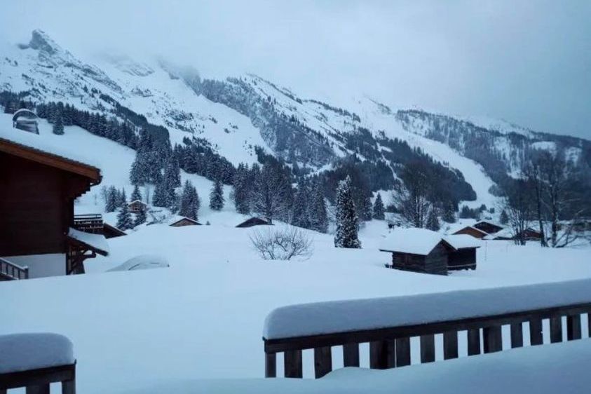
Updated: 10am Monday 31 January 2022 – Over 1m of snow for some norther parts of the Alps by Thursday!
The Alps are currently under the influence of an unstable north-westerly airflow, which is already producing some snow across the northern Swiss Alps (roughly from the Jungfrau region eastwards) and the northern Austrian Alps this morning.
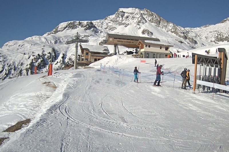
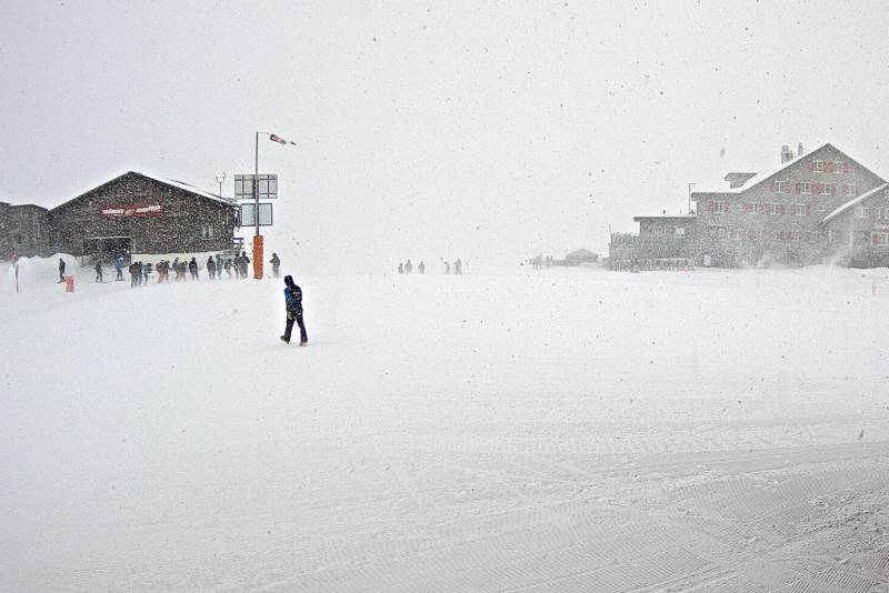 Heavy snow and high winds in Engelberg, which is likely to affect lift operations today – 31 January 2022 - Photo: titlis.ch
Over the course of the day, snow will start to fall more generally across the northern half of the Alps, heaviest from about central Switzerland eastwards, but lighter and patchier in the west of Switzerland and in the northern French Alps. The rain/snow limit will start at around 500-700m before lowering later in the day.
Between now and Tuesday morning, the following quantities of fresh snow can be expected above 1000m:
- 5cm: Val d’Isère, La Plagne, Courmayeur, Cervinia, Zermatt
- 10cm: Avoriaz, Flaine, Verbier, St Moritz, Obergurgl
- 25cm: Wengen, Laax, Klosters, Kitzbühel
- 30cm: Engelberg, Saalbach, Kaprun
- 45cm: Lech, St Anton
Both the northern and southern Alps will see very windy conditions, which will impact lift operations at altitude across the board. The southern Alps will, however, be less affected by the snow, with some places (e.g. Milky Way) staying completely dry.
On Tuesday, it will remain mostly cloudy across the northern Alps though the snow will ease for a time. On Tuesday night, though, another set of active fronts will bring even heavier snow to the northern and north-eastern Alps, lasting through Wednesday, with another 30-60cm possible from about central Switzerland eastwards.
This means that some of the Alps (e.g. the Austrian Arlberg) will have accumulated well over 1m of fresh snow by Thursday morning. Once again, the snow will be lighter in the north-western Alps (e.g. Portes du Soleil, 3 Valleys), and patchy or non-existent in the southern Alps.
Updated: 9.40am Friday 28 January 2022 – Snow for the north-eastern Alps today…
The weather in the Alps has turned more unsettled today, with a cold front moving down from the north, bringing some snow to the north-eastern Alps.
 Fresh snow in Upper Austria today. This is Bad Leonfelden – 28 January 2022 – Photo: snoweye.com
Today we are expecting a moderate fall of snow to low altitudes in the northern and eastern Austrian Alps, particularly in the Salzburgland (e.g. Kaprun, Obertauern) and Upper Austria (e.g. Hinterstoder, Gosau) where 10-15cm of fresh snow is possible.
The western Austrian Alps (e.g. St Anton) and the far eastern Swiss Alps are likely to see a dusting of snow, otherwise most other regions will be dry with more sunshine the further south and west you are.
Over the weekend many areas will be dry and bright, though flurries will continue in some eastern parts of the Alps. More active fronts will then bring widespread heavy snow to the northern half of the Alps early next week. More on this in our detailed snow forecast out later today…
Updated: 9am Thursday 27 January 2022 – All eyes on the north-eastern Alps, again!
It’s another mostly dry day today with some stubborn low cloud/fog in places, but also lots of sunshine at altitude, albeit hazier than in recent days in many areas. Tonight, a cold front could bring some light to moderate snow to some north-eastern parts of the Alps, chiefly in Austria.
 Sunrise in the SkiWelt in Austria, where considerable snowfall is expected over the next week or so – 27 January 2022 – Photo: facebook.com/skiwelt
This cold front is the beginning of a new storm cycle that will bring a succession of fronts down from the north or north-west over the next week or so. Once again it will be the Austrian Alps (away from the southern regions of Carinthia and Osttirol) that will generally see the most snow from this new storm cycle. However, the northern French Alps (e.g. Grand Massif, Portes du Soleil), and the northern Swiss Alps (e.g. Villars, Gstaad, Wengen, Engelberg, Laax, Klosters) could also see a spell of significant snowfall on Monday and Tuesday.
The southern Alps (e.g. Risoul, Isola 2000, Prato Nevoso, Sauze d’Oulx, Pila, Madesimo, Livigno, Alta Badia) will again miss most of the action, with little or snow forecast over the next few days. We will bring you a more detailed snow forecast for the Alps tomorrow…
Right now, the best snow conditions in the Alps are still to be found in the north-east, which saw most of last week’s snowfalls and where pockets of powder can still be found by those in the know or with the help of a good guide. Otherwise, most regions haven’t seen much in the way of new snow of late, although they can still offer good piste skiing, even if some lower runs are now getting a bit worn or icy.
Concerns remain though about the thin depth of the snowpack in the south-western Alps, including but not limited to resorts such as Auron, Isola 2000, Risoul, Prato Nevoso, Bardonecchia, Sauze d’Oulx and Pila.
These areas are going to need some big dumps soon to avoid problems later in the season, and there continues to be no sign of this happening any time soon.
Updated: 11.30am Wednesday 26 January 2022 – Another glorious day in the Alps!
It’s another mostly sunny day today in the Alps, with freezing levels ranging from about 1200m in the Austrian Alps, to 1500-2000m in the central Alps, and as high as 2800m in the far south-western Alps (Isola 2000).
 Sunny skies above Hochkönig in the Austrian Alps today – 26 January 2022 – Photo: hochkoenig.at
After another mostly fine day tomorrow, some light snow will reach the north-eastern Alps tomorrow night and continue into Friday. This will mostly affect Austria (away from the southern provinces of Carinthia and Ostirol) and the far north-eastern Swiss Alps (roughly east of Zurich), with a rain/snow limit between 400m and 700m. These regions are likely to see 2-10cm of new snow by the end of Friday, with perhaps 15-20cm in parts of Upper Austria (e.g. Hinterstoder), the north of Styria (e.g. Schladming) and the north of Salzburgland (e.g. Kaprun).
The north-western Alps (e.g. Chamonix, Villars, Wengen) will see no more than just a few clouds on Friday, while the southern Alps will again remain mostly sunny.
Over the weekend, further weak weather fronts will graze the north-eastern Alps bringing a few more centimetres of snow in places, chiefly in the northern Austrian Alps. A more active front may then deliver more widespread snow late on Monday and on Tuesday, but also bring a lot of wind to the northern Alps. We will bring you more details on this later this week…
The best snow conditions in the Alps are still to be found in the north-east, which saw most of last week’s snowfalls and where pockets of powder can still be found by those in the know or with the help of a good guide. Otherwise, most regions haven’t seen much in the way of new snow of late, although they can still offer good piste skiing, even if some lower runs are now getting a bit worn or icy.
Concerns remain about how thin the snow pack is in the south-western Alps though, including but not limited to resorts such as Auron, Isola 2000, Risoul, Prato Nevoso, Bardonecchia, Sauze d’Oulx and Pila.
These areas are going to need some big dumps soon to avoid problems later in the season, and there is no sign of this happening any time soon.
Updated: 10.30am Tuesday 25 January 2022 – More sun for the Alps!
High pressure continues to dominate the weather in the Alps, meaning plenty more sunshine in all areas today, with freezing levels between 1500m (in the eastern Austrian Alps) and 2500m (in the south-western Alps).
 Wall-to-wall sunshine across the Alps today. This is the Austrian resort of Turracher Höhe – 25 January 2022 – Photo: foto-webcam.eu
It will remain sunny on Wednesday and most of Thursday, though cloud will increase in the north late on Thursday, with snow expected across the northern and especially north-eastern Alps on Thursday night and Friday. Much like last weekend, most of the snow (10-30cm) will fall in Austria and the far eastern Swiss Alps, while the western Swiss and northern French Alps will probably catch no more than a few flurries.
Next week, a more powerful northerly airflow is expected to bring some heavier and more widespread snow to the whole of the northern Alps, although details are still uncertain at this stage. One thing that is certain though is that most of the southern Alps will again miss out.
Snow conditions are currently very good across much of Austria, especially in Salzburgland and Upper Austria where the heaviest of last weekend’s snow fell. By contrast, the southern Austrian Alps (e.g. Nassfeld), the western and southern Swiss Alps (e.g. Verbier, Zermatt), the French Alps and most of the Italian Alps have not seen any significant snow for some time – for many weeks in the case of the far south-western Alps (e.g. Sauze d’Oulx, Isola 2000).
That doesn’t mean that the skiing isn’t still good here - on-piste at least there is still some very enjoyable skiing to be had.
 It hasn’t snowed for weeks now in the far south-western Alps, and it shows! This is Prato Nevoso in the Italian Piedmont – 25 January 2022 – Photo: pratonevoso.com
There is concern about how thin the snow pack is in the south-western Alps now, however, including but not limited to resorts such as Auron, Isola 2000, Risoul, Prato Nevoso, Bardonecchia, Sauze d’Oulx and Pila.
These areas are going to need some big dumps soon to avoid problems later in the season, and there is no sign of this happening any time soon.
Updated: 9.45am Monday 24 January 2022 – Mostly sunny in the Alps today…
Some cloud is lingering across the far eastern Austrian Alps this morning, though it should break up as the day goes on. Just about everywhere else, there is plenty of sunshine, at least above any of the low cloud and fog that is trapped in some of the eastern valleys.
 Lots more sunshine for the French Alps over the next few days. This is Aussois in the Maurienne – 24 January 2022 – Photo: haute-maurienne-vanoise.com
The next few days will remain mostly sunny, but a new, relatively weak cold front will reach the Alps on Thursday night bringing some further mostly light snow to some northern and especially north-eastern parts of the Alps on Thursday night and Friday.
Snow conditions are excellent right now in the northern and eastern Austrian Alps, especially in the lesser-known resorts of the northern Salzburgland and Upper Austria (such as Tauplitz, Loser, Hinterstoder, Gaissau-Hintersee and Bad Ischl) where the heaviest of the recent snow has fallen.
Elsewhere across the northern Alps (e.g. 3 Valleys, Grand Massif, Portes du Soleil, Verbier, Jungfrau Region, Engelberg) there was only a dusting of new snow late last week but there is still some very good skiing right now, on-piste at least. Off-piste snow conditions in these regions are more variable, however.
Good piste skiing can also be found in many southern parts of the Alps, despite the lack of new snow in recent weeks. The one main area for concern continues to be the far south-west (e.g. Auron, Isola 2000, Prato Nevoso, Sauze d’Oulx, Bardonecchia) where snow depths are way below average for the time of year.
These resorts will get away with it for now, especially as there will be no dramatic rise in temperature any time soon, but there could be problems later in the season if there isn’t any serious snowfall over the next few weeks.
Updated: 12.45pm Sunday 23 January 2022 – Mostly sunny in the Alps for the next few days…
It’s still cloudy with the odd flurry across the far north-eastern Austrian Alps today, but elsewhere it is mostly sunny, if still rather cold. The sun will continue to dominate over the next few days before a new weather front sees snow returning to the northern Alps on Thursday night and Friday.
 Sunny again in St Anton, with the fine weather expected to last until Thursday at least – 23 January 2022 – Photo: stantonamarlberg.com
Over the last two or three days, a lot of snow has fallen across some northern and eastern parts of the Austrian Alps, particularly in the Salzburgland and Upper Austria which have quite widely seen between 30cm and 50cm.
Snow conditions are obviously now excellent in the northern and eastern Austrian Alps, especially in the lesser-known resorts of the northern Salzburgland and Upper Austria (such as Tauplitz, Loser, Hinterstoder, Gaissau-Hintersee and Bad Ischl).
Despite have only seen a dusting from the latest storm cycle (most of which fell early on Thursday), and only a few centimetres in the western Austrian resorts (e.g. Lech), the rest of the northern Alps can also offer some good skiing, especially on-piste.
Good piste skiing can also be found in many southern parts of the Alps, despite the lack of new snow in recent weeks. The one main area for concern continues to be the far south-west (e.g. Auron, Isola 2000, Prato Nevoso, Sauze d’Oulx, Bardonecchia) where snow depths are way below average for the time of year.
These resorts will get away with it for now, especially as there will be no dramatic rise in temperature any time soon, but problems are possible later in the season if there isn’t any serious snowfall over the next few weeks.
Updated: 10.30am Saturday 22 January 2022 - Further snow for parts of Austria…
It’s a cloudy day across the north-eastern Alps with heavy snow for parts of Austria, notably the Salzburgland, Upper Austria, northern Styria and the far north and east of the Tirol, where an additional 15-30cm is expected today (with more in places), with a relatively low rain/snow limit of 300m-600m.
 Heavy snow today in Hinterthal in the Austrian Salzburgland – 22 January 2022 – Photo: snoweye.com
This is not quite as much as originally forecast a couple of days ago, although yesterday did see more than snow than expected (with 25cm in some spots) in parts of the Salzburgland and Upper Austria, so 48-hour storm totals will still end up around 50-60cm in the most favoured spots by tomorrow morning (as originally predicted).
There will also be a few light flurries today in the west of Austria and the extreme east of Switzerland, but it will otherwise be a dry day for most of the Alps, with plenty of sunshine in the south and west.
A few snow flurries will linger in the north-eastern Austrian Alps tomorrow morning, otherwise most of the Alps will again be dry and sunny. Indeed, the weather in the Alps will then remain fine for several days before things start to break down from the north-west on Friday.
As for snow conditions, they are obviously going to be excellent in the northern and eastern Austrian Alps over the next few days, especially in the lesser-known resorts of the northern Salzburgland and Upper Austria (such as Tauplitz, Loser, Hinterstoder, Gaissau-Hintersee and Bad Ischl).
Despite have only seen a dusting from the latest storm cycle (most of which fell early on Thursday), and only a few centimetres in the western Austrian resorts (e.g. Lech), the rest of the northern Alps still have plenty of snow and are skiing pretty well, especially on-piste.
Good piste skiing can also be found in many southern parts of the Alps, despite the lack of new snow in recent weeks. The one main area for concern continues to be the far south-west (e.g. Auron, Isola 2000, Prato Nevoso, Sauze d’Oulx, Bardonecchia) where snow depths are way below average for the time of year.
These resorts will get away with it for now, especially as there will be no dramatic rise in temperature any time soon, but problems are possible later in the season if there isn’t any serious snowfall over the next few weeks.
Updated: 8.50am Friday 21 January 2022 – Snow for the north-eastern Alps, especially tomorrow…
It’s a cloudy morning in the northern Alps (roughly from central Switzerland eastwards) with a few flurries to low levels, chiefly in the Salzburgland where around 5-10cm is possible. Elsewhere in the Alps, it is mostly sunny but cold, and by this afternoon most of the snow showers will be confined to the northern and eastern Austrian Alps.
 Cold with light snow this morning in the Austrian Salzburgland. This is Hinterthal – 21 January 2022 – Photo: bergfex.com
Tomorrow the southern and western Alps will be dry and mostly sunny, while the north-east will again see some snow. This time it will be heavy and persistent in the north-eastern Austrian Alps, especially in the far north-east of the Tirol (e.g. Kitzbühel), the northern Salzburgland (e.g St Wolfgang) and Upper Austria (e.g. Hinterstoder), where they may see 20-40cm of fresh snow on Saturday alone, with 50cm or more in some spots.
Some flurries are also likely in western Austria (e.g. St Anton) and eastern Switzerland (e.g. Braunwald) tomorrow, though they will not amount to very much. It will feel cold right across the Alps, however.
For more details, check out our more detailed snow forecast for the Alps later today…
Updated: 9am Thursday 20 January 2022 – Light snow for some northern parts of the Alps today…
As expected, some light snow reached the northern Alps last night, with flurries continuing today, chiefly across the north-eastern Swiss and northern Austrian Alps. The southern side of the Alps will remain dry with plenty of sunshine but it will be noticeably colder across all regions.
 Light snow this morning in Lech where about 5cm is expected by the end of today – 20 January 2022 – Photo: lech.com
By tonight, snowfall totals will be between 1cm and 5 cm in the north-western Alps (e.g. Portes du Soleil, Villars, Jungfau region), 3-8cm in the north-eastern Swiss Alps (e.g. Flumserberg) and the western Austrian Alps (e.g. Lech), and 5-15cm in the northern and north-eastern Austrian Alps (e.g. Kitzbühel), with perhaps even 15cm or more in the far east (e.g. Hinterstoder).
On Friday, apart from a few flurries in the north-eastern Austrian Alps, most places will be dry but cold with the sunniest skies the further south and west you are. Some significant snow is expected across the north-eastern Alps on Saturday, with around 50cm possible in parts of Salzburgland and Upper Austria.
Updated: 10am Wednesday 19 January 2022 – Significant snowfall for some north-eastern parts of the Alps over the next few days…
It will be another mostly sunny day in the Alps today, with freezing levels typically starting between 1500m and 2000m, but dropping sharply later in the day.
 Another fine day in Obertauern but significant snow is on its way, heaviest on Saturday – Photo: foto-webcam.eu, 19 January 2022
Some light snow will move into the northern Alps tonight, including the northern French Alps (e.g. 3 Valleys, Grand Massif), with 2cm-5cm of fresh snow expected above 1000m by tomorrow morning - a little upgrade from yesterday’s forecast!
On Thursday, snow flurries will continue to low altitudes across the north-eastern Swiss Alps and much of Austria (excluding the southern regions of Osttirol and Carinthia). The southern Alps will remain dry, however.
Flurries will continue across the north-eastern Alps on Friday with some heavier snow likely on Saturday in Austria (away from the far south), also lasting into Sunday. The western Alps, and especially the southern Alps, will stay mostly dry with sunny spells.
Between now and Sunday morning the following snowfall totals are expected at 1500m:
- 2-5cm: 3 Valleys, Portes du Soleil
- 5-10cm: Mürren, Engelberg, Laax
- 20cm: Arlberg
- 40-60cm: Saalbach, Kitzbühel, Kaprun, Schladming, Obertauern
Updated: 9am Tuesday 18 January 2022 – Mostly fine, with snow for some northern parts of the Alps later in the week…
A little like yesterday, there is some cloud in the far north-eastern Alps (e.g. Upper Austria) with the odd flurry this morning, however, for most regions it will be another gloriously sunny day.
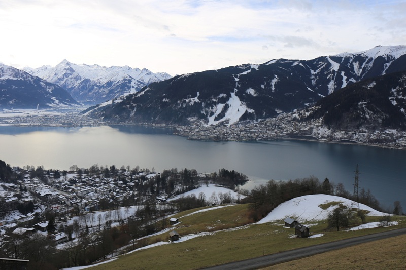
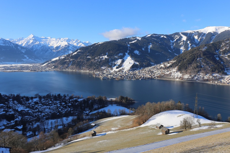 Blue skies over the lake at Zell-am-See, Austria, with snowy mountains in the background – Weather to ski – Today in the Alps, 18 January 2022
After another mostly fine day tomorrow, some snow will fall to low levels in the northern half of the Alps on Thursday and Friday. The heaviest of this will fall in the Austrian Alps and the north-eastern Swiss Alps. Some northern parts of the Austrian Alps (including the likes of Saalbach and Kaprun) may well see the snow continue for most of Saturday. However, the northern French Alps (e.g. Portes du Soleil, Grand Massif, Tarentaise) will see only a dusting at best.
Between Wednesday night and Saturday morning, the following snowfall totals can be expected at 1500m:
- 1-2cm: Avoriaz, Flaine
- 3-5cm: Mürren, Wengen,
- 5-10cm: Laax, Klosters,
- 20-30cm: Lech, St Anton, Kaprun, Saalbach
During this period the southern Alps (i.e. Italy, the far south of Switzerland and the far south of Austria) will stay dry with plenty of sunshine.
Snow conditions in the Alps generally remain good on-piste but are increasingly mixed off-piste. There is still cold powdery snow to be found with the help of a good guide in the north-western Alps, where most of the snow fell earlier in the month. However, snow cover is generally quite modest in the southern Alps, especially in the south-western Alps (e.g. Sauze d’Oulx, Isola 2000) where it is extremely thin lower down.
This isn’t a problem on-piste for now, but it could become so later in the season if there aren’t any significant snowfalls over the next few weeks.
Updated: 10am Monday 17 January 2022 – Mostly fine, dusting of snow in the north-eastern Alps…
It’s cloudy across the north-eastern Alps this morning, with a few light flurries in the far eastern and north-eastern Austrian Alps. Most other regions are dry, with lots of sunshine across the central, western and southern Alps.
 Sunny skies again in Les Saisies – 17 January 2022 – Photo: lessaisies.com
The cloud in the north-eastern is the remnants of a weak cold front that arrived from the north yesterday, bringing a dusting of snow to some northern parts of the Austrian Alps (e.g. Salzburgland, Upper Austria).
Tuesday and Wednesday will be mostly dry and sunny across the Alps, with just the far north-eastern Alps seeing some cloud on Tuesday. On Thursday a slightly stronger cold front will reach the northern Alps, bringing a few centimetres of snow to low levels across the northern Swiss and northern Austrian Alps on Thursday and Friday, with as much as 30cm in some favoured parts of Austria but probably little or nothing for the northern French Alps. The southern half of the Alps will remain dry with some sunny spells.
Snow conditions in the Alps generally remain good on-piste but are increasingly mixed off-piste. There is still cold powdery snow to be found with the help of a good guide in the north-western Alps, where most of the snow fell earlier in the month.
However, snow cover is generally quite modest in the southern Alps, especially in the south-western Alps (e.g. Sauze d’Oulx, Isola 2000) where it is extremely thin lower down. This isn’t a problem (on-piste) for now, but it could become so later in the season if there aren’t any significant snowfalls over the next few weeks.
Updated: 9.45am Friday 14 January 2022 - Another sunny day in the Alps…
High pressure remains in charge of the weather in the Alps, with today being another day of almost wall to wall sunshine. It will feel pleasantly mild in the sun at altitude, especially in the west where freezing levels will again reach or exceed 3000m.
 Perfect weather again in Alpe d’Huez today – 14 January 2022 – Photo: alpedhuez.net
As for snow conditions, they remain excellent across the north-western Alps (e.g. Val d’Isère, Méribel, Flaine, Chamonix, Avoriaz, Verbier, Villars, Crans Montana, Mürren, Engelberg, Lech), where most of the recent snow has fallen. The high freezing levels are not of any major concern either as the sun is still low in the sky which, combined with low humidity, means that any melting/softening of the snow will mostly be confined to low altitude south-facing slopes.
Conditions are also generally pretty good elsewhere in the Alps, especially on-piste, although snow depths are very modest in some south-western parts of the Alps (e.g. Prato Nevoso, Isola 2000) where artificial help is needed, especially lower down.
As for the forecast, a little snow is possible across the north-eastern Alps (e.g. Salzburgland) on Monday, but there is no sign of any heavy widespread snow any time soon. See our latest detailed weather & snow forecast for the Alps for more details...
Updated: 9.40am Thursday 13 January 2022 – Sun, sun, sun!
High pressure continues to dominate the weather in the Alps, with predominantly sunny skies expected again today. The low cloud/fog which has plagued some valleys in recent days, especially close to the western foothills, has also largely dissipated.
 Perfect weather across most of the Alps today. This is Aussois in the Maurienne valley in the Savoie – 13 January 2022 – Photo: haute-maurienne-vanoise.com
Temperatures are also creeping up with freezing levels expected to be close to 3000m in the western Alps today, making it feel very pleasant at altitude, out of any breeze.
As for snow conditions, they remain excellent across the north-western Alps (e.g. Val d’Isère, Méribel, Flaine, Chamonix, Avoriaz, Verbier, Villars, Crans Montana, Mürren, Engelberg, Lech), where most of the recent snow has fallen. The high freezing levels are not of any major concern either. The sun is still low in the sky and, with low humidity, any melting/softening of the snow will mostly be confined to those low altitude slopes exposed to the south.
Conditions are also generally pretty good elsewhere in the Alps, especially on-piste, although snow depths are on the lower side in the south-western Alps (e.g. Isola 2000, Risoul, Bardonecchia, Sestriere).
So the big question is when will it snow next? The answer is that, for most of the Alps, no significant snow is likely any time soon, however, a northerly/north-easterly flow might bring some snow to the Austrian Alps early next week, though there is still lots of uncertainty over this. Stay tuned for updates!
For more detail on what snow conditions are like across the Alps and beyond, check out our weekly snow report later today…
Updated: 9am Wednesday 12 January 2022 - Mostly sunny in the Alps…
The sun is shining across virtually the entire Alps today, at least above any of the low cloud which is still plaguing some northern and especially western valleys, where the upper limit is around 1200m. Freezing levels will be close to 2000m in the western Alps, but typically around 500m in the east (i.e. much of Austria).
 Low cloud trapped in the valley around Grenoble this morning, with an upper limit around 1200m. This is Chamrousse – 12 January 2022 – Photo: chamrousse.com
Over the next few days, the weather in the Alps is expected to remain mostly sunny but it will turn milder, with freezing levels reaching 3000m in the west.
Right now, snow conditions are excellent across the north-western Alps (e.g. Val d’Isère, Méribel, Flaine, Chamonix, Avoriaz, Verbier, Villars, Crans Montana, Mürren, Engelberg, Lech), where most of the recent snow has fallen. Conditions are also generally pretty good elsewhere in the Alps, especially on-piste, although snow depths are on the lower side in the south-western Alps (e.g. Isola 2000, Risoul, Bardonecchia, Sestriere).
The next snowfall of any note is currently forecast to fall early next week in the north-eastern Alps (i.e. Austria), but there is still some uncertainty over this, so stay tuned!
Updated: 9.40am Tuesday 11 January 2022 – Glorious weather across most of the Alps…
The weather in the Alps has settled down, with lots of sunshine expected today across most regions. That said, cloud/fog is still plaguing some lower valleys, especially close to the northern and western foothills, with more general cloud cover across the far eastern Austrian Alps.
 Clear skies this morning over the Monte Rosa region – 11 January 2022 – Photo: visitmonterosa.com
Over the next few days, it will turn milder and stay mostly sunny, especially at altitude. Right now, snow conditions are superb across the north-western Alps (e.g. Val d’Isère, Méribel, Flaine, Chamonix, Avoriaz, Verbier, Villars, Crans Montana, Mürren, Engelberg, Lech), where most of the recent snow has fallen.
Conditions are also generally pretty good elsewhere in the Alps, especially on-piste, although snow depths are on the low side in the south-western Alps (e.g. Isola 2000, Risoul, Bardonecchia, Sestriere).
Updated: 9.50am Monday 10 January 2022 – Improving weather conditions in the Alps!
Aside from some flurries to low levels in the north-eastern Alps (especially northern Austria), today will be mostly dry in the Alps, with variable cloud cover but with a tendency for it to become increasingly sunny, at least at altitude. Temperatures will be cool across the board due to the influence of a cool north-easterly airflow.
 Improving weather conditions across the Alps. This is Chamrousse – 10 January 2022 – Photo: chamrousse.com
Over the next few days, it will be mostly dry with plenty of sunshine at altitude, but also some cloud trapped under temperature inversions in the lower valleys, especially close to the northern and western foothills of the Alps. Temperatures will slowly become milder, especially at altitude where it will feel increasingly pleasant with the winds easing as the week goes on.
Snow conditions are generally good across the Alps right now, and even excellent in the north-west where most of the recent snow has fallen. However, do take extra care off-piste as the risk of avalanche remains high thanks to all the recent wind and snow.
Updated: 11.30am Sunday 9 January 2022 – Very snowy in the north-western Alps…
It’s a cloudy day across the northern Alps with snow showers to low levels, heaviest and most persistent in the north-west. Snow flurries will be fewer and farther between the further south and east you are, with the best of any sunshine across the far south-east (including the Dolomites).
 Lots of fresh snow this morning in La Clusaz – 9 January 2022 – Photo: facebook.com/meteoalpes
Today we can expect another 10-20cm of fresh snow across the north-western Alps in areas such as the 3 Valleys, the Grand Massif, the Portes du Soleil, Verbier, Gstaad and the Jungfrau region. The north-eastern Alps (e.g. Tirol, Salzburgland) will also see some flurries today but with only very modest accumulations.
With the exception of some border areas (particularly in the north-west - e.g. Courmayeur), any snowfall totals in the southern Alps will also be very modest with many places staying dry.
This heavy snow in the north-western Alps comes on top of the snow that fell on Friday night. Snowfall totals between Friday night and Sunday night are therefore likely to be quite considerable in the northern French and western Swiss Alps, with typically 30-40cm above 1500m but 50cm or more in some favoured spots.
Some flurries will persist across the northern Austrian Alps on Monday, otherwise most areas will be dry with the best of any sunshine the further south and west you are. For the most part though, after a relatively cold start, next week will generally see plenty of fine weather with increasingly mild temperatures.
Snow conditions next week look like being excellent across the north-western half of the Alps where most of the new snow has fallen. Elsewhere they will be a bit more mixed – generally pretty good on-piste, but with low snow depths and limited off-piste in the south-western Alps (e.g. Sauze d’Oulx).
Updated: 9.45am Friday 7 January 2022 – More snow on the way for the Alps…
It’s a lovely start to the day across most of the Alps, although the next storm is already approaching the north-western Alps with some light snow expected to low altitudes across the northern French and western Swiss Alps this afternoon.
 A fine start to the day in Engelberg but high cloud is already starting to move in from the north-west – 7 January 2022 – Photo: facecook.com/engelberg.titlis
This snow will spread a bit further east this evening and overnight, mostly affecting the northern half of the Alps. The southern Alps will see a few light flurries in places, mostly close to the north-western border areas, although some areas will stay completely dry (e.g. the Dolomites).
Another more potent storm will reach the north-western Alps tomorrow evening – we will bring you more details in our latest detailed forecast out later today…
Updated: 10am Thursday 6 January 2022 – Sunny and cold across most of the Alps today…
Some flurries are continuing to low altitudes across the northern Austrian and north-eastern Swiss Alps this morning, but for most of the Alps it will be a cold but sunny day.
 Fresh snow and clearing skies this morning in Bad Kleinkirchheim, Carinthia – 6 January 2022 – Photo: badkleinkirchheim.com
Tomorrow will start dry and bright but, during the afternoon, new weather fronts will bring snow to low altitudes across the north-western Alps (especially in the northern French and western Swiss Alps). These fronts will push further east on Friday night, gradually dying out as they do so.
Saturday is then a case of rinse and repeat with a dry, bright start for most, but further weather fronts moving in from the north-west later in the day and on Saturday night, continuing to influence the weather on Sunday. These fronts will again be most active in the northern French and western Swiss Alps, and less significant the further east and south you are.
Between now and Sunday evening, between 30-50cm of new snow can be expected across the northern French, western Swiss and far north-western Italian Alps (e.g. 3 Valleys, Portes du Soleil, Verbier, Jungfrau Region, Courmayeur), with 15-30cm across the eastern Swiss and far western Austrian Alps (e.g. Klosters, St Anton), but little if any snow in the far eastern and most southern parts of the Alps (e.g. the Dolomites). We will bring you a more detailed weather forecast for the Alps tomorrow.
For more on snow conditions in the Alps, check out our latest detailed snow report out later today…
Updated: 10.20am Wednesday 5 January 2022 – Winter returns to the Alps!
After the mildest New Year period on record in the Alps, winter has finally returned with fresh snow for most (but not quite all) regions today.
 15cm of new snow in Les Saisies this morning – 5 January 2022 – Photo: lessaisies.com
This change in the weather comes courtesy of an active cold front that arrived from the north-west last night. A secondary storm has also developed on the arrival of this cold air in the Mediterranean, meaning that the heaviest snow will fall in the far south-eastern Alps (notably Carinthia and the far eastern Dolomites) later today.
This morning, the snow is already dying out across the northern French and western Swiss Alps where between 10-20cm has fallen at 2000m with a dusting to as low as 600-800m. By contrast, the snow will linger for most of the day across the central and (especially) the eastern Alps, becoming heavier in the far south-east later.
So, while storm totals at 2000m in the eastern Swiss Alps (e.g. Davos, St Moritz) and much of Austria (e.g. St Anton, Kaprun) are likely to be in the range of 10-25cm, the Dolomites might see 30cm or more by tomorrow morning, with parts of Carinthia (e.g. Nassfeld) seeing 50-60cm! The southern French and south-western Italian Alps will miss most of the action this time around, with just a dusting in Sestriere and nothing at all in Isola 2000.
While natural snowfall may be variable, the good news is that it has turned much colder everywhere which will allow the snow cannons to operate at full capacity again across the Alps.
A few flurries will linger across the northern and north-eastern fringes of the Alps for a while on Thursday, otherwise most other areas will be fine, if still rather chilly. Further snow is then expected on Friday and Saturday night, mostly in the north-western half of the Alps.
After what has been a very difficult 10 days or so in the Alps, starting with unwelcome rain (especially in the north-western Alps) followed by the mildest New Year on record, snow conditions in the Alps are now clearly improving. Luckily, most resorts already had enough snow to ride out the unusually warm spell, but it some lower slopes have been left a bit worn or thin in places.
We will bring you more detailed information on snow conditions in the Alps in our weekly country by country report tomorrow…
Updated: 12pm Tuesday 4 January 2022 – Winter to return to the Alps tonight…
There is a lot of cloud across the Alps today, thickest in the north where the odd shower or flurry (2200m) cannot be ruled out, with the best of any brightness across the southern Alps (e.g. the Dolomites).
 Clear signs of the recent warm weather in Zell-am-See, but there is snow in the forecast here tomorrow – Photo: zellamsee-kaprun.com, 4 January 2022
As previously reported, there will be a big change in the weather tonight with the arrival of an active cold front from the north-west. This front will bring snow to increasingly low levels across many parts of the Alps tonight or tomorrow, first hitting the northern French and western Swiss Alps this evening, then the south-eastern Alps (e.g. Dolomites) tomorrow morning.
The rain/snow limit will begin at around 1800m before lowering to under 1000m in most areas by tomorrow morning, with snow then falling to all levels during the last of the flurries in the south-eastern Alps tomorrow evening.
By the end of Wednesday, this storm will have delivered 10-30cm of snow at 2000m across most of the Alps (despite it easing from the western Alps quite early in the day) and as much as 40-50cm in the extreme east of the Dolomites and parts of Carinthia (e.g. Nassfeld) where it will re-intensify for a while on Wednesday evening. The southern French Alps (e.g. Risoul) and western/south-western Italian Alps (e.g. Sestriere) will see little if any snow, however.
Here are some of the expected snowfall totals at 2000m over the next 36 hours:
- Nassfeld - 50cm
- Alta Badia - 30cm
- Obergurgl - 25cm
- St Moritz - 25cm
- St Anton - 20cm
- Avoriaz - 20cm
- Val d’Isère - 10cm
- Zermatt - 10cm
- Serre Chevalier - 5cm
- Sestriere - 2cm
Looking a bit further ahead, some early flurries may linger across the far north-eastern Alps on Thursday, but most areas can expect a dry day with plenty of sunshine. The weather will remain unsettled, however, with further fronts set to move in from the north-west late on Friday, with some light to moderate snow (to relatively low levels) likely later in the day and on Friday night across the north-western half of the Alps.
More active fronts will reach the Alps later on Saturday and on Sunday, with the prospect of further snow, heaviest across the north-western Alps (e.g. northern French, Swiss and western Austrian Alps), but lighter and patchier in the southern Alps.
This week’s change in weather is welcome news for the Alps, which have endured their warmest New Year period on record. Luckily, the thaw wasn’t as catastrophic as it might have been, thanks to there already being quite a bit of snow around and given the weak sun at this time of year, and most major resorts are still holding up quite well.
That said, the forecast snowfalls will bring considerable relief to lower resorts where cover has been getting a bit thin in places.
Updated: 3.45pm Monday 3 January 2022 – Mid-week snow for most (but not all) parts of the Alps…
After several days of mostly sunny and exceptionally conditions, the weather in the Alps is on the change.
 Mild but cloudy across the northern Alps today. This is Mellau in the Austrian Vorarlberg – 3 January 2022 – Photo: mellau.at
Temperatures have remained mild today, but large areas of cloud have drifted around, thickest closest to the northern fringes of the Alps where there has also been the odd shower or flurry (1800m).
Tuesday will start off in a similar fashion – quite mild with plenty of cloud around and still the odd shower or flurry (2000m) – before active fronts start moving towards the Alps from the north-west in the evening, lingering close to the south-eastern Alps throughout Wednesday. The rain/snow limit will initially sit around 2000m on Tuesday but will fall steadily overnight and on Wednesday.
By Wednesday night, we can expect 10-30cm of new snow across a wide swathe of the Alps, with perhaps more in some parts of the Dolomites (e.g. Cortina) and southern Austria (e.g. Nassfeld) where the storm is expected to re-energise later on Wednesday.
The only Alpine region that won’t see much snow from this storm is the south-west – i.e. the southern French Alps (e.g. Risoul, Isola 2000) and the Italian Piedmont (e.g. Sestriere).
Updated: 11.30am Sunday 2 January 2022 - Still exceptionally mild in the Alps, but colder mid-week…
The weather in the Alps remains unusually warm today, even if we are no longer at the record-breaking levels that we have seen in the last couple of days.
 Looking decidedly spring-like on the lower slopes of Bardonecchia – 2 January 2022 – Photo: bardonecchia.it
Some areas of medium or high-level cloud are drifting around today, but there is also plenty of sunshine, with freezing levels somewhere between 2800m and 3500m.
Monday will remain mostly dry and bright, though the odd shower (or high-altitude flurry) cannot be ruled out across the western Alps later in the day. There will not be a significant change in the weather until late on Tuesday, when an active cold front will move in from the north bringing much colder conditions to all parts of the Alps by Wednesday. There will also be some snow, especially in the northern half of the Alps, with a rain/snow limit starting quite high but falling to well below 1000m over the course of Tuesday night.
Although the exceptionally mild temperatures of recent days have led to a rapid thaw and deterioration of snow conditions at lower altitudes, this has been far from disastrous for a couple of reasons. Firstly, there was already a lot of snow across much of the Alps, and secondly, the sun is still very weak at this time of year, meaning that it has not compounded the thaw as it would later in the season.
So, although snow depths have taken quite a hit below 2000m or so, most lower resorts are still comfortably skiable down to village level.