


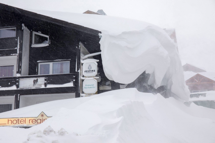
Updated: 9.50am Wednesday 30 January 2019 - Remaining wintry in the Alps…
It’s snowing some parts of the Alps this morning, mostly in the north-west, and especially in the northern French Alps (e.g. Morzine, Avoriaz, Flaine) where there is at least 20cm of fresh on the ground.
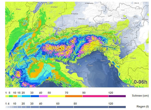 Estimated snowfall totals in the Alps between now and Saturday 2 February 2019 – Image: bergfex.com, 30 January 2019
Elsewhere in the Alps there are bits and pieces of new snow here and there but, it is generally the French ski resorts have done best this time around. What’s more, it is still cold, which means that any snow has fallen to very low levels.
The weather in the Alps will remain unsettled over the next few days, but the heaviest snow will fall in the southern Alps - i.e. the French Alps roughly south of Grenoble, most of the Italian Alps, and parts of southern Switzerland (e.g. St Moritz) and southern Austria (e.g. Nassfeld). These regions will see significant new snow between Thursday night and Saturday, with the very heaviest falls (potentially in excess of 1m) reserved for the south-east (e.g. Passo Tonale, Dolomites).
This is great news for the southern Alps, which have not seen very much snow at all this year, and will go some way to redressing the balance between the north and the south.
With the busy half term week little more than a fortnight away, the snow situation in the Alps is a very encouraging one right now.
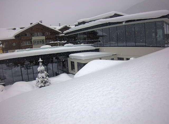
Updated: 10.30am Tuesday 29 January 2019 - Near perfect snow conditions for the north-western Alps this morning!
The sun is back out across the north-western Alps this morning where conditions are just about perfect, with cold temperatures and plenty of new snow.
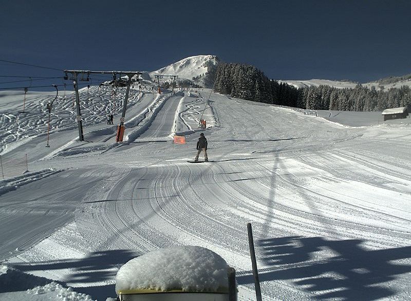 Fabulous snow conditions in the Portes du Soleil this morning. This is Morgins – 29 January 2019 – Photo: telemorgins.ch
By the north-western Alps we mean the northern French Alps (especially the Haute-Savoie - e.g. Portes du Soleil) and the central and western Swiss Alps (e.g. Wengen/Mürren). Most other northern parts of the Alps are also in good condition though there is currently more cloud and less new snow across the north-east (i.e. Austria).
The sun is also out across the southern Alps today, though snow depths here are generally more modest. There is still some excellent piste skiing to be had, but decent off-piste opportunities are more limited.
As for the forecast for the rest of the week, it will remain unsettled with further snow at times. This time the areas most likely to see significant snow will be the western and southern Alps (i.e. the French and Italian Alps), although Italy will have to wait until Thursday/Friday before things really get going.
So all in all it’s a very positive picture in the Alps right now. Not everywhere has masses of snow, but thanks to the cold temperatures just about everywhere can offer some very enjoyable skiing.
Updated: 9.15am Monday 28 January 2019 - Significant new snow for the north-western Alps…
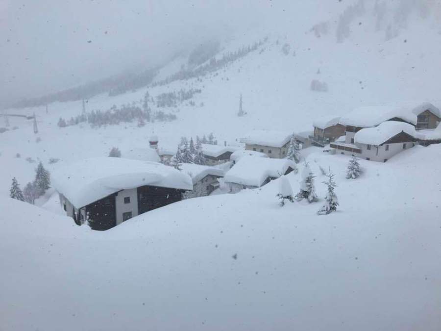
There has been quite a bit of snow to very low levels in the north-western Alps in the last 24 hours, with plenty more due this week. The Portes du Soleil has done as well as anywhere from this, and (at 8am this morning) storm totals since Sunday are already in excess of 25cm in Châtel (1200m) and 40cm in Avoriaz (1800m).
 40cm of new snow in Avoriaz this morning – 28 January 2019 – Photo: avoriaz.com
Most of the snow from this latest storm has fallen in the northern French and western Swiss Alps (e.g. Val d’Isere/Tignes, 3 Valleys, Les Arcs, Flaine, Chamonix, Portes du Soleil, Gstaad, Jungfrau region). However, many other parts of Switzerland (away from the far south), and parts of western Austria (e.g. Lech) have also seen a moderate fall of snow. The eastern and southern Alps have seen little if any new snow.
As for the forecast for the rest of the week, there will be further snow at times, mostly in the western Alps early and mid-week, but increasingly favouring the southern Alps later in the week.
Snow conditions in the Alps are generally very good, with lots of powder in the northern French, central and western Swiss Alps right now (though note that the risk of avalanche is now quite high off-piste). There is also plenty of good skiing elsewhere, especially on-piste, helped by the generally cold temperatures.
Updated: 9.30am Thursday 24 January 2019 - Cold, a little fresh snow for some…
The weather in the Alps remains cold. Most places are dry this morning, though there are still a few flurries across some northern and eastern parts of the Alps, and the far south-west close to the Mediterranean.
 Lots of sunshine at altitude across the Alps today. This is Heiligenblut – 24 January 2019 – Photo: foto-webcam.eu
One feature of the weather in the Alps today is the amount of low cloud plaguing the northern Alps - if it’s cloudy in resort where you are, it could still be sunny at altitude.
Looking a bit further ahead, the next significant snow in the Alps will arrive on Sunday and Monday. This will fall to low levels, and will be heaviest in the French and western Swiss Alps this time around. Stay tuned for further details…
Thanks to the cold temperatures, snow conditions generally remain very good, especially on-piste. There is also still some powder to be found (especially with the help of some local knowledge), mostly across the northern Alps.
Updated: 9.50am Wednesday 23 January 2019 - Still cold, a bit of snow in places…
The weather in the Alps this morning is again divided into sections. In the central Alps (i.e. the eastern Swiss and western Austrian Alps it is relatively clear, albeit with some high cloud in places. However, in the western Alps (especially the French and western Italian Alps) and the far eastern Alps (notably the Dolomites) the cloud is thicker and there are some flurries in places.
 Rather cloudy in the Tux valley today but it should stay mostly dry – 23 January 2019 – Photo: foto-webcam.eu
Any snow flurries in the French Alps have so far mostly been confined to the western foothills (e.g. Villard-de-Lans, west of Grenoble). These flurries will make some progress into the Alpine interior as the day goes on but will generally remain very light. They will also remain light in the western Italian Alps (e.g. Sestriere), with the exception of the far south-west where resorts close to the Mediterranean (e.g. Limone) could pick up 15-20cm.
There has already been a little fresh snow overnight in the far eastern and south-eastern Alps, where they can expect a little more during the course of the day in resorts such Cortina, Selva, Nassfeld, and Obertauern.
Wherever you are in the Alps today, it will be cold again, so wrap up warm. Snow conditions are generally very good though, especially on-piste, but you can still find some powder in the northern Alps if you know where to look.
Looking a bit further ahead, it will remain relatively cold for the foreseeable future with further chances for snow at times. Right now, the heaviest and most widespread snowfall is likely to be on Sunday.
Updated: 9am Tuesday 22 January 2019 - Lovely skiing conditions for many parts of the Alps…
The weather in the Alps remains cold. Today will be mostly dry with plenty of sunshine, above any low-lying cloud or valley fog. However, it will cloud over more generally in the western Alps later in the day with a little light snow for some French resorts tonight. Another region that might catch some light snow tonight is the far eastern Alps (eastern Austrian Alps and Dolomites), though it won’t amount to much.
 Cold but fine across much of the Alps this morning. This is Warth-Schröcken – 22 January 2019 –Photo: warth-schroecken.at
On Wednesday, the weather in the Alps will again continue to be split into three distinct sectors. The western Alps – i.e. the French Alps, western Swiss Alps (e.g. Verbier) and the western Italian Alps (e.g. Sestriere) – will be mostly cloudy with some occasional snow to low levels. The eastern Alps will also be cloudy with a little snow, mostly to the south and east of Salzburg stretching into the Dolomites. In between, a good chunk of the Alps will be drier with variable cloud but also some sunny spells. Wherever you are it will be cold with freezing levels somewhere between 0m and 700m.
Looking a bit further ahead, it will remain on the cold side all week with further bits and pieces of snow here and there and perhaps some heavier more widespread snow on Sunday.
Snow conditions remain generally good across most of the Alps even if there is still great disparity between snow depths on the northern and southern side of the chain. The northern Alps generally have the deepest snow, especially in Austria and Switzerland, while the southern Alps have the least. However, you don’t necessarily need a lot of snow to provide good on-piste skiing conditions, as anyone in the Dolomites right now would be happy to testify.
Meanwhile, things are looking up for the Pyrenees (which have had a pretty miserable season to date) with new snow in most resorts and a lot more in the forecast. Indeed some areas on the northern side of the Pyrenees could see as much as a metre over the next few days.
Updated: 10am Monday 21 January 2019 - Cold, a little snow for some mid-week…
It’s a cold but mostly dry day today in the Alps. Although there are some areas of cloud floating around, most regions will see plenty of sunshine which will make for some very good skiing conditions. While the extreme cold forecast a few days ago may no longer be on the cards, it will still feel very chilly by most standards, especially at altitude. Wrap up warm!
 Fine but cold in Avoriaz this morning – 21 January 2019 – Photo: avoriaz.com
Most areas will be fine again on Tuesday, but cloud will increase in the western as the day progresses, with a little snow (to low levels) possible for the French Alps late in the day or overnight.
On Wednesday, further (mostly light) snow is likely to fall across the French, western Swiss and western Italian Alps (e.g. Sestriere). Some snow may also clip the south-eastern Alps (Carinthia, Dolomites) but, in between, most central and eastern parts of the Alps will stay dry with sunny spells. It will remain cold with any snow flurries falling at all levels.
Snow conditions in the Alps will be pretty good this week. In most of Austria and eastern Switzerland the snow remains exceptionally deep and there is still some powder to be found, with the help of a good guide.
Snow depths are much more modest across the southern Alps, but cold temperatures, snow-making and the occasional small top-up of natural snow have also made for some excellent skiing jere, especially on-piste.
Updated: 1pm Sunday 20th January 2019 – Extreme cold this week less likely than originally forecast…
Regular readers will be aware that we were talking about some exceptionally cold weather arriving in the Alps later this week. Fortunately (in most people’s opinion) the weather models are now moving towards a less extreme scenario.
 Winter wonderland in Zell-am-See – 20 January 2019 – Photo: zellamsee-kaprun.at
It will still be cold, even very cold for some from mid-week onwards, but just not quite as cold as had been originally predicted.
For most of the Alps there will be lots of dry and fine weather this week. However, there will be snow for some, most of which will fall in the western and south-western Alps mid-week (e.g. Les 2 Alpes, Isola 2000, Sestriere).
As for snow conditions, they are generally very good across the Alps right now, helped by the relatively cold and calm weather we have seen of late. The deepest snow remains in the eastern Swiss and Austrian Alps (away from the far south).
The shallowest snowpack is (on the whole) in the lower resorts of the southern Alps, including the Dolomites, although these regions are still offering some very good piste skiing.
Updated: 9am Thursday 17 January 2019 - Lots of sun today, light snow for many tomorrow…
Following a beautiful day in the Alps yesterday, a new weather front is now approaching from the north-west today. It won’t be very active but it will bring some light snow to quite a wide swathe of the Alps later today and tonight. A secondary weather feature will also develop in the Mediterranean which will intensify the snow across the far south-eastern Alps (Dolomites) tonight.
 Lovely morning in Hochkönig, Austria but some light snow is expected later – 17 January 2019 – Photo: hochkoenig.at
By tomorrow morning we can expect at least a dusting across many parts of the Alps, with as much as 10-15cm across some favoured parts of the northern Alps such as Avoriaz, Mürren and Lech. Watch out for some more significant snowfall in parts of the Dolomites, especially in the east (from Cortina eastwards) where upwards of 20cm is possible, indeed neighbouring Slovenia could see as much as 50cm or more.
Areas most likely to miss out on any snow in the next 24hrs are the southern French Alps (e.g. Risoul, Isola 2000) and the far south-western Italian Alps (e.g Prato Nevoso, Limone).
There will still be a few flurries here and there over the weekend, but many parts of the Alps will stay dry and relatively chilly. We are then looking at the distinct possibility of the weather turning seriously cold across the Alps next week. This classic ‘deep winter’ set-up is difficult to forecast in terms of snow, but it is most likely to favour the southern Alps later next week. Stay tuned…
Updated: 2.30pm Wednesday 16 January 2019 - Lots of sun today, light snow for many tomorrow…
There is a lot of sun across the Alps today, at least above any low cloud trapped in some of the valley bottoms. It’s also quite mild, making for some very pleasant skiing conditions indeed.
 Lovely day for skiing (on-piste) in super snowy Oberstdorf on the German-Austrian border – 16 January 2019 – Photo: oberstdorf.de
However, be aware that the risk of avalanche remains high right across the northern Alps, where huge amounts of snow have fallen in recent days. For now, the advice is still to stick to the pistes.
Tomorrow, a new cold front will arrive from the north-west. It won’t be very active but it will bring some light snow to quite a wide swathe of the Alps. It will also signal the start of a colder spell of weather for the Alps which will last into next week. Indeed, later next week some very cold weather could arrive from the east (to be confirmed).
Updated: 10am Tuesday 15 January 2019 - The big clear up begins!
The last of the snow from this now infamous storm cycle is dying away from the eastern Alps and the MASSIVE clear up operation is underway in earnest. The weather in the Alps may be improving, but the avalanche risk remains sky high across most of the northern Alps and, at the time of writing, some resorts (e.g. Lech) remain cut off.
 The weather is settling down in the Austrian Vorarlberg after two weeks of near continuous snow. This is Schröcken – 15 January 2019 – Photo: warth-schroecken.at
There are exceptional snow depths right now in the central and eastern Swiss Alps in resorts such as Engelberg (55/500cm) and Andermatt (95/600cm), and across most of the Austrian Alps (away from the far south), in resorts such as St Anton (100/480cm), Obergurgl (170/320cm) and Obertauern (250/290cm). Remember these are settled snow depths as reported by piste patrol. In terms of cumulative snowfall, some of these regions have seen 3-4m of new snow since the turn of the year.
The northern French Alps have also benefited from more new snow over the last few days than initially forecast, with around 30-60cm in resorts such as Val d’Isère, Chamonix and Avoriaz.
Some useful snow did get through here and there in the southern Alps, notably close to the Swiss border (e.g. Cervinia, Livigno). The Dolomites even had 10cm of much needed snow yesterday but, on the whole, most southern Alpine resorts again missed the heaviest of the precipitation.
Back to the forecast, and the next few days will be much quieter across the Alps than we have seen in recent weeks. That doesn’t mean the weather will be completely fine, in fact there is likely to be some quite widespread but light snowfall across the Alps on Thursday. However, we will not see anything like the intensity of the storms that have battered the northern Alps in recent days, at least for the time being.
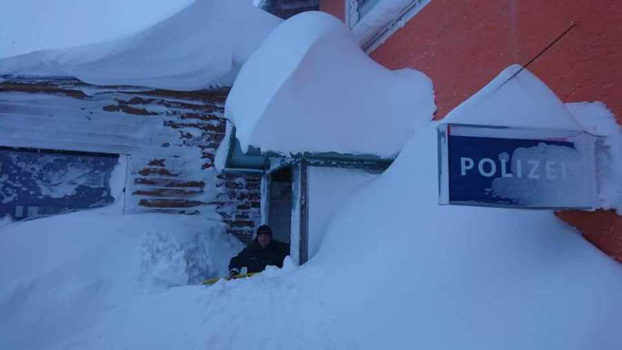
Updated: 12pm Monday 14 January 2019 - Chaos in the Alps!
It has been snowing almost continuously across the northern half of the Alps for nearly three days now, with the heaviest snow falling in Switzerland and Austria. Some resorts of the northern French Alps have also seen significant accumulations.
 Stuben, in the Austrian Arlberg, is one of many resorts now cut off – 14 January 2019 – Photo: Peter Torkington
The amount of snow that has fallen is causing major problems in some Swiss and Austrian ski resorts where the avalanche risk is at its highest level (5/5), and numerous villages are now cut off. Among the better known resorts that are currently unreachable (due to the risk of big avalanches reaching the valley bottoms) are St Anton, Lech, Ischgl and Obergurgl, but there are dozens more.
The snow will begin to ease off across the northern French and north-western Swiss Alps today but will continue in the eastern Swiss and Austrian Alps (away from the far south) all day and most of tonight.
Storm totals from last Saturday to tomorrow morning, when the storm finally peters out will be:
- Across the northern French Alps: 20-60cm(e.g. Flaine, Avoriaz);
- Across the Swiss Alps: most areas will have seen 40-90cm, though some favoured spots will have well over 100cm at altitude (e.g. Engelberg). Only some parts of the far south, notably Ticino will have missed out on a significant fall;
- In Austria: 40-100cm in many northern and western resorts, with closer to 1.5m in some parts of the far west (e.g. near St Anton and Lech).
Some snow has been getting through to parts of the southern Alps (e.g. Cervinia) but generally resorts here have again seen very little if any new snow in recent days.
The weather in the Alps will be much calmer from tomorrow though. While there will be further bits and pieces of snow later in the week, it will generally be quite light.
Needless to say, it will take considerable time to make some of the ski areas that have seen such huge snowfalls in recent days (e.g. St Anton) safe, so don’t even think about venturing off-piste unless you have authorisation from local authorities and are with a properly qualified local guide.
Updated: 10.15am Saturday 12 January 2019 - Lots more snow to come for the northern Alps!
The weather in the Alps remains very unsettled, with a succession of fronts moving down from the north-west over the next 48 to 72 hours. After a brief lull in the weather on Saturday, the next front (a warm one) will make its presence felt in the northern Alps on Saturday night and will continue to affect the weather on Sunday. This will then be followed by a very active cold front on Sunday night.
 Remaining unsettled with lots more snow to come across the northern Alps over the next few days. This is Ischgl – 12 January 2019 – Photo: ischgl.com
The rain/snow limit will start very low tonight, and will remain low (600m or lower) in the internal valleys (such as the Swiss Valais) for much of Sunday. Closer to the northern foothills of the Alps (e.g. Morzine, Wengen), it will rise to 600-800m by tomorrow morning, then to 1000-1200m for a time later on Sunday.
On Sunday night, a very active cold front will sweep through the Alps, intensifying the precipitation and lowering the rain/snow limit to between 400m and 700m by Monday.
Between now and Monday night, a further 40-80cm of new snow will fall at altitude across a wide swathe of the northern Alps, with some central and eastern Swiss and western Austrian resorts seeing another metre or more.
The Arlberg/Vorarlberg region (e.g. St Anton, Lech, Warth-Schröcken) currently looks like it will be in the sweet spot. However, the big resorts of the Tarentaise such as Val d’Isère, La Plagne and Val Thorens may not do quite as well, and are more likely to see in the region of 15-30cm.
As for the southern Alps, some snow will get through here and there, but there will generally be much less snow here than in the northern half of the Alps.
Updated: 8.40am Friday 11 January 2019 - Small weather window in the Alps!
It has (almost) stopped snowing across Austria this morning, with just a few residual flurries in the east. So, overall, there will be plenty of fine weather in the Alps today, although the next weather front (a warm one) is already approaching and will reach the northern Alps this evening.
 Better weather in Lech today but it won’t last long – 11 January 2019 – Photo: lech.com
This warm front will bring further snow to the northern Alps both tonight and early tomorrow, with snow initially falling at all levels before the rain/snow limit rises to between 500m and 700m close to the northern foothills.
This first front will only bring a moderate fall of snow (5-20cm) to the northern half of the Alps. However, after another short lull in the weather on Saturday, a more active set of fronts will arrive on Saturday night/Sunday bringing much heavier snow back to the northern Alps. These fronts will be followed by another ‘northern stau’ (or ‘blockage’) which will last into Monday and deliver huge quantities of new snow to the very areas that already have too much!
Between now and Monday evening we could see another metre of more of new snow at altitude in some ‘favoured’ parts of the Austrian Alps, such as Lech and St Anton. The rain/snow limit will start between 600m and 1000m, but will drop back to low levels later.
This latest storm will also bring a lot of snow to the northern half of the Swiss Alps (e.g. Mürren, Engelberg, Laax), with a bit less (though still useful) snow in the northern French Alps (e.g. Avoriaz, Flaine, 3 Valleys). Bits and pieces of snow will also get through to the southern Alps, but once again most southern Alpine regions will see little if any (e.g. Dolomites).
Updated: 9.30am Thursday 10 January 2019 - “Critical snow situation” remains across parts of Austria…
The snow in Austria will begin to ease today, but the situation on the ground remains critical in many areas, with yet more heavy snow forecast this weekend. The situation will be further complicated by the arrival of milder air on Sunday, which will turn some of this snow to rain at low altitudes.
 This map gives you a good idea of where the worst affected areas in Austria are. The red areas represent the highest avalanche risk – Image: zamg.ac.at, 10 January 2019
Before this next storm arrives, the northern Alps (including Austria) will have a temporary reprieve tomorrow when, for the first time in quite a while, it should stay mostly dry. Needless to say, skiers in the areas affected by the recent heavy snow should avoid the temptation to “jump in” as the risk of avalanche will remain sky high.
Back to today and the worst affected areas in terms of snowfall disruption are the Vorarlberg, the Tirol, the Salzburgland, western Styria, Upper and Lower Austria and parts of Bavaria (Germany). Some resorts in these regions have seen well over 1m of new snow in the last 48 hours, with upwards of 3m of new snow since the New Year.
We must reiterate that any off-piste activity in these areas is completely out of the question for the time being. Stick to the open pistes and, if you have any doubts about what you are doing, always consult a fully qualified local guide. Drivers and pedestrians also need to pay attention to local advice and avoid closed roads and footpaths – they are always closed for a reason!
Many other northern parts of the Alps have also seen snow over the last couple of days. Even if quantities were relatively modest – around 10-15cm in the Tarentaise (e.g. Val Thorens) and 30cm in Avoriaz in the Portes du Soleil – this has been very welcome in the northern French Alps where it hasn’t snowed properly for some time. The north-western Swiss Alps (e.g. Mürren) have seen around 30-60cm in the last 48 hours, while the central-north-eastern Swiss Alps (e.g. Engelberg, Flumserberg, Klosters) have had 50-90cm.
Meanwhile, the southern Alps have seen little or no new snow in the last few days, and weeks even, with no prospect of any significant snowfall any time soon. Indeed the next big storm due this weekend will again mostly affect the northern Alps.
For a full round up of snow conditions across the Alps and beyond, check out our next snow report due out later today.
For a detailed weather forecast for the Alps, check out our next detailed forecast, out tomorrow.
Updated: 9.15am Wednesday 9 January 2019 - Extreme snowfall continues in Austria…
The Alps remain under the influence of a vigorous northerly airflow, with lots more snow to come across the northern half of the Alps today. By contrast, the southern Alps will remain mostly dry with sunny spells, protected by the “North Foehn”. However, wherever you are in the Alps today it is likely to be very windy.
 Extreme snow conditions in Obertauern – 9 January 2019 – Photo: Bernd März via Alpenweerman.nl
The snow situation across some parts of Austria is now what could be classified as extreme – a once in a generation type event in parts of the Tirol, Salzburgland, Styria, Upper and Lower Austria. The Vorarlberg also has a huge amount of snow but they are more used to it here, so the current snowfall is considered less unusual.
Nearly all ski resorts in these parts of Austria are on at least a 4/5 (very high) avalanche danger rating, with some on the maximum 5/5 (extreme), with more resorts likely to reach the maximum level during the course of today. Needless to say, any off-piste activity in these areas is completely out of the question. The snow is also causing problems with infrastructure in these areas, including road closures and in some cases villages being entirely cut off.
If you are in the affected parts of Austria right now, the advice is simply to follow the advice of the local authorities. Do not ski outside of any open pistes, do not walk or drive on any closed roads or footpaths, and stay tuned to local media reports.
Elsewhere in the Alps, there has been a lot of snow in some central and eastern parts of Switzerland (e.g. Laax, Davos) where the avalanche risk is also very high. Snow has also fallen further west in the north-western Swiss and northern French Alps, though in more moderate quantities, with no more than a few centimetres in the mega resorts of the Tarentaise, such as Val d’Isère and La Plagne.
Back to the forecast and it will continue snowing all day across most parts of the northern Alps, heaviest in Austria and eastern Switzerland where it will continue for much of tomorrow. In the north-western Alps, especially in France, it will be more moderate and will die way during the course of the day tomorrow.
By Thursday we can roughly expect the following snowfall totals from this latest storm (i.e. since yesterday):
- Northern French Alps: 5-35cm - highest in resorts close to Lake Geneva and the Swiss border (e.g. Avoriaz);
- North-western Swiss Alps (e.g. Gstaad, Wengen): 30-50cm;
- Central and north-eastern Swiss Alps (e.g. Engelberg, Flumserberg, Klosters): 50-80cm, with more in places;
- Northern Austrian Alps (e.g. Lech, Saalbach, Hochkönig, Gosau): 80-150cm. This is of course on top of all the snow that these north-eastern Alpine resorts have already had in recent days – bringing snowfall totals since the New Year to well over 300cm in places.
By contrast, the southern Alps have seen very little if any snow in recent days, and weeks even and will continue to miss out over the next few days. The Dolomites, for example, are heavily reliant on artificial snow but it has, at least, generally been sunny, meaning that there has been some perfectly good skiing on offer.
We will go into much more detail with regards to snow conditions right across the Alps in our main snow report tomorrow.
Updated: 1pm Tuesday 8 January 2019 - Here we go again!
Here we go again! It had hardly stopped snowing in Austria when the next active cold front arrived early this morning. This means a lot more snowfall across Austria (away from the far south) over the next 48 hours. There will also be snow across other northern parts of the Alps, although western Switzerland and France will see lighter snow than Austria and eastern Switzerland.
 Incredible snowfalls in Obertauern, Austria – 8 January 2019 – Photo: obertauern.at
Between Tuesday and Thursday we can expect another 40-70cm across many northern and north-eastern parts of the Alps, roughly from about Engelberg eastwards into Austria and southern Germany. Some favoured spots such as the Arlberg/Vorarlberg may even see another metre or more at altitude. The rain/snow level will rise temporarily to between 500m and 900m in places today before it falls back to very low levels again tonight and tomorrow.
By contrast, the north-western Swiss and northern French Alps will see less snow, with perhaps 20-30cm close to the northern foothills (e.g. Portes du Soleil) but only 5-15cm at best in the mega resorts of the Tarentaise such as Val Thorens or Tignes. The southern French Alps, most of Italy and parts of southern Switzerland and southern Austria will again see little or no snow from this latest storm.
Back to Austria and the snow situation here has become exceptional in certain regions, especially in the northern Tirol, Salzburgland, Upper Austria and Styria where resorts such as Saalbach, Kitzbühel, Zell-am-See and Schladming have not seen this much snow for many years. Indeed there is talk of this potentially being the snowiest winter in these areas since 1978-79.
With this much snow there is inevitably a high risk of avalanche, and there have already been several avalanche-related fatalities. Any off-piste activity in these snowy areas should be considered as completely out of the question until further notice.
As for the forecast later in the week, Friday should see a temporarily lull in the bad weather but yet more snow is forecast over the weekend, again most of it across the northern half of the Alps.
Updated: 1.30pm Monday 7 January 2019 - Plenty more snow to come for the northern Alps…
It is still snowing across parts of Austria today, especially in the Salzburgland, north-western Styria and Upper Austria, albeit not as heavily as in recent days. Elsewhere in the Alps it is mostly dry and quite sunny even, especially the further south and west you go.
 A rare glimpse of blue sky in the Austrian Vorarlberg, but the snow will return tomorrow. This is Schröcken – 7 January 2019 – Photo: warth-schroecken.at
On Tuesday and Wednesday a new set of weather fronts will arrive from the north, meaning further heavy snow is on the cards for Austria (away from the far south). This time the north-western Alps will be more involved though, especially the Swiss Alps (again away from the far south). The northern French Alps will also see some snow but not in the same quantities as in Switzerland or Austria. The southern Alps will miss most of the snow.
Between now and Thursday we can expect around 10-30cm of new snow across the northern French Alps (e.g. Avoriaz, Flaine, 3 Valleys), 20-50cm across the central northern and north-western Swiss Alps (e.g. Villars, Mürren, Engelberg), and 30-70cm across the eastern Swiss and Austrian Alps (excluding Carinthia and Osttirol), with the sweet spot probably in the Vorarlberg/Arlberg region (e.g. Warth, Lech, St Anton) where 1m of new is possible at altitude. The rain/snow limit may creep up to between 600m and 900m on Tuesday before it descends to the lowlands again on Wednesday.
Needless to say, the off-piste situation remains exceptionally dangerous across a wide swathe of the northern and especially north-eastern Alps where well over 2m of new snow has fallen in places since the turn of the year.
Looking ahead to the second half of the week and next weekend, it will remain unsettled with further snow at times, mostly (again) across the northern Alps. Thursday and Friday will still be cold but it should have turned a bit milder by the weekend, raising the rain/snow limit to between 600m and 1000m.
Updated: 12.20pm Sunday 6 January 2019 – Over 2m of new snow in parts of Austria!
It’s still snowing across many parts of Austria today, with snowfall totals since the turn of the year now in excess of 2m in parts of the Tirol, Salzburgland, Styria and Upper Austria.
 Huge amounts of snow in the lower Austrian ski resorts. This is Zell-am-See – 6 January 2019 – Photo: twitter.com/@Clemens_Grohs
Even the classic low Austrian ski resorts such as Kitzbühel, Saalbach, Söll, Ellmau, Zell-am-See and Schladming have HUGE amounts of snow. In fact these low Austrian resorts are the best place to be right now as, thanks to their largely tree-lined terrain, most of their slopes have remained open during the storm. By contrast, higher resorts such as Obertauern have only been able to open a handful of runs in recent days due to high winds and blizzard conditions.
Some eastern parts of Switzerland (e.g. Klosters, Samnaun, Flumserberg, Laax) have also seen significant snow over the last few days, but most other parts of the Alps, including France and much of Italy, have seen no significant snow for quite some time.
The snow will ease off for a time tomorrow, but a new storm will bring further heavy snow to the Austrian Alps on Tuesday, which will continue for most of the week. This new storm will equally affect the Swiss Alps (at least away from the far south), but the snow will be more moderate in the French Alps. It will also be cold, with any snow falling to very low levels.
Stay tuned for further updates tomorrow…
Updated: 3pm Saturday 5 January 2019 - Snow is now becoming problematic in parts of Austria!
Guess what? It’s still snowing in Austria! In fact, if anything the snow has intensified today thanks to the arrival of a new set of weather fronts from the north.
 Disruptive snowfall in Obertauern, Austria – 5 January 2019 – Photo: twitter.com/@Cieminfo
The first of these fronts is actually a warm one but, with lots of cold air already in place, plus the fact that the cold front behind it is rapidly catching up, the rain/snow limit will still remain low today. It is also snowing across some parts of Switzerland, especially in the central and eastern Swiss Alps (e.g. Laax, Klosters). However, aside from the odd flurry, most French and Italian resorts have again missed out.
The snow will continue across much of Austria (away from the far south) both tonight and tomorrow, easing only temporarily on Monday before it returns on Tuesday and lasts for much of next week.
 Heavy snow again in Lech today – 5 January 2019 – Photo: lech.com
This almost continuous snowfall will no doubt cause plenty of problems. With a sky high risk of avalanche, it is imperative that you not venture off-piste. Local infrastructure, such as exposed roads and buildings, may also be affected. The areas most at risk of disruption are the Austrian Vorarlberg, Tirol, Salzburgland and parts of Styria and Upper Austria. These areas could see another 50-100cm of new snow this weekend alone, then much more again next week!
Elsewhere in the Alps, some parts of Switzerland are now seeing snow today, but the French Alps will have to wait until Tuesday before they get in on the action, and even then huge amounts of snow are not expected. It is also unlikely that the southern Alps will see any serious snow any time soon.
Tune in for updates tomorrow when we should have a clearer idea of how disruptive this unusually snowy spell in Austria is proving…
Updated: 11am Friday 4 January - The snow continues in Austria…
The weather in the Alps remains stuck in a rut, with lots more snow to come in the north-eastern Alps (i.e. Austria) over the next few days, but mostly dry weather in the western and southern Alps. That said, it looks like some other areas (such as France) might get in on the action towards the middle of next week.
 The snow is really piling up in Obertauern – 4 January 2019 – Photo: obertauern.com
Back to today and it is snowing again to low levels across some north-eastern parts of the Alps, especially the northern Tirol and Salzburgland. By contrast, the French Alps are again mostly sunny, as are many parts of the Swiss and Italian Alps, at least away from the Austrian border.
Tomorrow, a new set of weather fronts will actually intensify the snow across the Austrian Alps. There will also be high winds, which could make for some particularly difficult skiing (not to mention) driving conditions, especially at altitude. This snow could again hit some eastern parts of Switzerland but the weather will generally be drier and brighter the further west and south you are, and it will probably remain sunny across the French and western Italian Alps.
With little or no let up in the stormy weather across the Austrian Alps this Sunday (or indeed next week too) snowfall totals could become unusually high in parts of the north Tirol, Salzburgland, Upper Austria and Styria. There has already been 50cm and 120cm of snowfall in some of these areas over the past few days, and an additional 100cm to 150cm is possible in places by early next week, especially to the east of Innsbruck. Needless to say, do not even consider venturing off-piste in these snowy eastern Alpine areas for the time being!
As mentioned earlier, the snow-starved French and western Swiss Alps may get in on the action by the middle of next week, but how much snow will fall is still uncertain. Stay tuned…
Updated: 11am Thursday 3 January 2019 - Snow, snow and more snow – but mainly in Austria…
There has been a lot of snow across most Austrian ski resorts in recent days, with plenty more in the forecast. Resorts in the far south (i.e. Carinthia and parts of Osttirol) have missed out this time around, but just about all other parts of Austria now have masses of snow!
 Snowy scenes in Haus am Ennstal in Styria – 3 January 2019 – Photo: haus.at
This is great news for the “classic low Austrian resorts” such as Kitzbühel, Saalbach, Söll and Zell-am-See, which have struggled somewhat with natural snow in recent years and have often been heavily reliant on artificial back up. Right now though, these same resorts are wallowing in the white stuff.
What’s more, with further significant snow in the forecast over the next week (and maybe even the next two weeks) we can safely say that most of Austria is now “set” for the season.
 Huge snowfalls in the northern Austrian Alps. This is Gröbming near Schladming – 3 January 2019 –Photo: schladming-dachstein.at
But what about the rest of the Alps?
Well, some of the recent snow has also hit eastern Switzerland, especially close to the Austrian border (e.g. Klosters), but the western Swiss Alps (e.g. Zermatt, Verbier), the French Alps and much of the Italian Alps have seen very little if any snow from this latest storm cycle.
And that’s exactly how things are going to stay over the next few days, with more snow for Austria (and at times eastern Switzerland) but little or nothing again further south and west.
 Brighter skies in the western and southern Alps. This is the Alta Badia region – 3 January 2019 – Photo: altabadia.org
As for snow conditions, they are clearly now excellent across much of Austria even if there are some issues with high winds and blizzards at altitude. Fortunately there are lots of low altitude areas with trees in Austria (e.g Ski Welt, Saalbach, Schladming, Kitzbühel) which offer more shelter in adverse weather conditions.
There is still plenty of good piste skiing on offer in areas where it hasn’t snowed for some time (e.g. France), especially at altitude, but many lower slopes here are now worn or icy.
Updated: 12.30pm Wednesday 2 January 2019 - Very snowy for some eastern parts of the Alps…
Since we last reported there has been some significant snowfall on the eastern side of the Alps, with plenty more to come over the coming days! This has mostly benefited Austria, although some parts of eastern Switzerland have also seen some useful snow. By contrast, there has been little or no snow in the French and western Swiss Alps, and much of the southern Alps (i.e. Italy) over recent days.
 Heavy snow in Lech this morning – 2 January 2019 – Photo: lech.com
The snowy weather pattern across the north-eastern Alps is the result of a vigorous northerly airflow between an area of high pressure to the north-west and low pressure to the north-east. In the north-western Alps (e.g. Portes du Soleil) the pressure is too high to squeeze any moisture from the northerly airflow. However, a weather phenomena known as the “northern stau” is in full effect in the north-eastern Alps (e.g. Salzburgland), effectively blocking the air mass as it hits the Alps, forcing rapid cooling, condensation and precipitating cloud masses.
The “northern stau” produces a lot of snow in the foothills and initial mountain ranges of the northern Alps, with a gradual easing of the intensity and frequency of showers the further south you are. As the area of high pressure is on this occasion located close to the north-western Alps, it is the northern Austrian Alps that have seen the most snow.
 Alpine radar at 9am this morning (with pinks and purples showing where it is snowing) – 2 January 2019 – Image: wetteronline.de
So, all in all, things are looking very promising across much of Austria, with significant snow to low levels and more to come over the next few days, with only some southern parts of Austria (Osttirol and Carinthia) having missed out on the heavy snow.
As for the rest of the Alps, while some Swiss ski resorts to the east of the Bernese Oberland have also seen snow (with quite a lot close to the Austrian border), most western Swiss (e.g. Verbier, Zermatt), French and Italian ski resorts have seen little or no snow in recent days.
Unfortunately, with the weather stuck in a bit of a rut, there is no sign that these areas will see any new snow any time soon either. Instead it will again be Austria (away from the far south) and some eastern parts of the Swiss Alps that will see the lion’s share over the coming days…
 The weather is mostly fine (above any low cloud) across the western Alps. This is La Clusaz – 2 January 2019 – Photo: laclusaz.com