


ARCHIVE
Today in the Alps - December 2021
Read about current weather and snow conditions in the Alps
Updated: 3pm Thursday 30 December 2021 – An exceptionally warm end to 2021…
The Alps are currently under the influence of an exceptionally warm airmass of tropical origin, with the possibility of some temperature records being broken over the next couple of days.
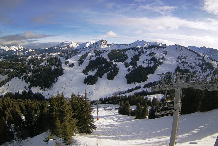 Brighter skies in Les Gets today after yesterday’s rain, though it remains exceptionally mild – 30 December 2021 – Photo: lesgets.com
There are still some showers (snow 2300m) today across the northern and north-eastern Austrian Alps, otherwise elsewhere in the Alps it is generally quite sunny and very warm, with freezing levels as high as 3700m in the southern French Alps!
Friday and Saturday will be mostly sunny right across the Alps, with exceptionally high, potentially record-breaking temperatures in some south-western regions. In the southern French Alps, for example, freezing levels could reach 3800m with maximum temperatures of 15°C at 1500m!
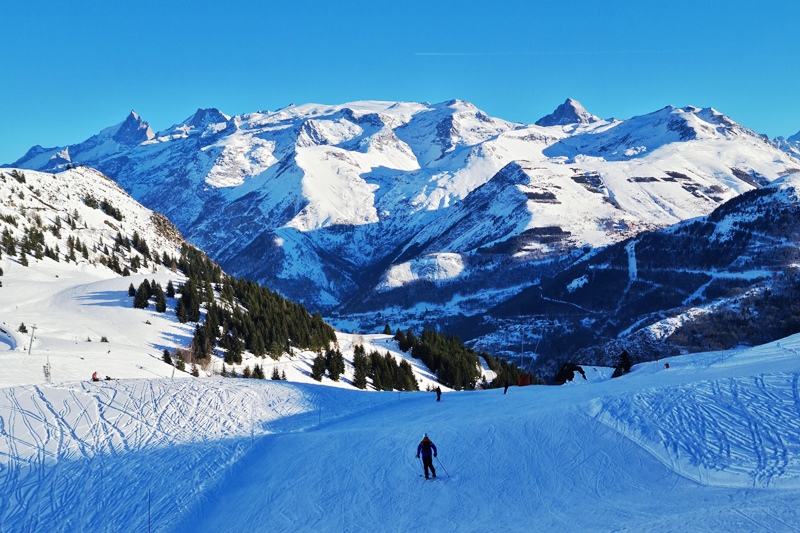
Needless to say, snow conditions across the Alps are very mixed right now. Over the last couple of days there has been a lot of snow at high altitude in the north-western Alps but also a lot of rain lower down. Yesterday the rain/snow limit reached as high as 2700m in the northern French and western Swiss Alps, while in the more enclosed internal valleys of the western Alps it snowed for longer than expected, resulting in 50cm of snow in Val d’Isère, for example, before the milder air eventually won out.
Whatever the case, the snowpack is now very humid across much of the Alps, especially below 2500m in the northern and western Alps where there has been lots of rain or wet snow. The southern and especially south-eastern Alps (e.g. Dolomites) have largely avoided any rain, meaning that snow conditions here are generally more consistent than elsewhere.
We will bring you a more detailed snow report later today…
Updated: 10.30am Wednesday 29 December 2021 – Very unsettled but exceptionally mild!
The weather in the Alps remains very unsettled, with an exceptionally high rain/snow limit later today (especially across the north-western Alps) due to the airmass having originated in the tropics.
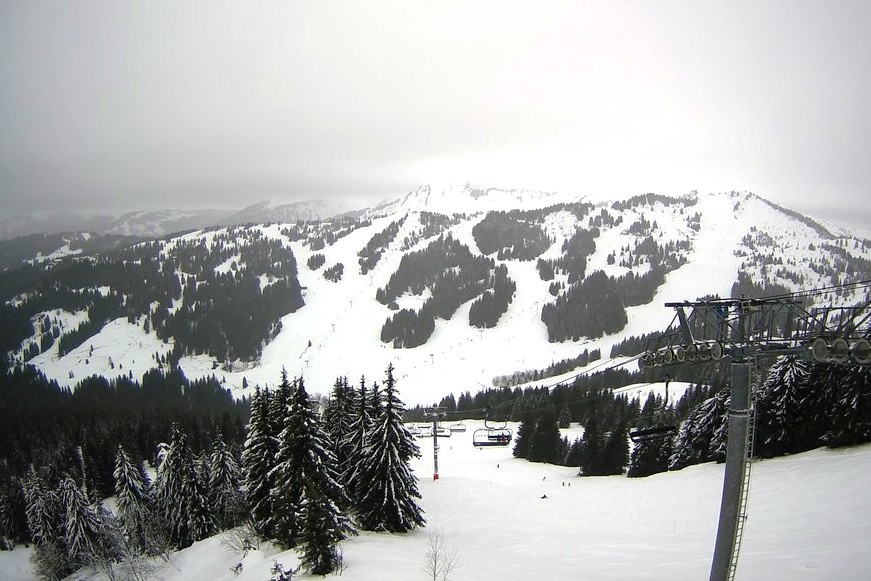 Rain to 2000m this morning in Les Gets, with the snow limit expected to rise to 2700m this evening! – 29 December 2021 – Photo: lesgets.com
This morning it is already very wet across the northern French and western Swiss Alps, with a highly variable rain/snow limit, already at or above 2000m in the exposed ranges of the north-western Alps (including the Portes du Soleil) but as low as 1200m in the enclosed valleys of the Swiss Alps (e.g. the Swiss Valais).
The rain/snow limit will continue to rise everywhere over the course of the day, generally reaching 2400m-2600m in the north-western Aps by tonight, and perhaps even 2800m in some exposed areas - as high as we have ever seen it in mid-winter!
Not only is a lot of rain going to fall across the north-western Alps today, but there is also going to be a lot of snow at high altitude, with around 40-60cm above 2700m in areas such as the Massif de Mont Blanc, the Glacier de Diablerets, the Jungfrau region and Engelberg. All this rain and snow is naturally going to cause problems in the Alps, with both a high risk of avalanches, and of flooding and landslides lower down.
The further south and east you are, the more sporadic and less problematic any precipitation will be today.
Some rain (and high altitude snow) will linger across the northern and north-eastern Alps for a while tomorrow, otherwise most areas will see the weather becoming drier and brighter. It will remain exceptionally mild though – as it will over the next few days – with freezing levels as high as 3800m in places!
Updated: 1pm Saturday 25 December 2021 - Mild, humid, variable weather and snow conditions…
The weather in the Alps has turned much more unsettled since we last reported, but NOT in a particularly wintry way.
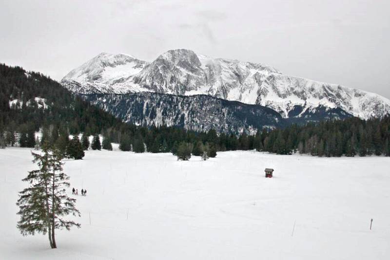 A scene typical of the Alps today and over the next few days, with plenty of snow still but often cloudy and mild weather – 25 December 2021 – Photo: chamrousse.com
Indeed, there is a very complicated synoptic situation right now with several slow-moving weather fronts draped over or near the Alps. The Alps will be very cloudy with some showers here and there, mostly in the French and Swiss Alps where there will be a little snow above 1600-1800m (lower in some enclosed intra-Alpine valleys). Most of the Alps will be dry though, with the best of any sunshine in the southern Austrian Alps.
Over the next few days, the weather will remain unsettled but mild with further rain or snow in places, mostly in the western Alps. The rain/snow limit will remain relatively high, between 1300m and 1800m. The driest and brightest weather is likely to be in Austria, especially in the eastern Austrian Alps.
The weather will settle down again towards the New Year, but it will become very mild, especially at altitude.
Snow conditions in the Alps have deteriorated somewhat in the last few days, unsurprisingly given the mild humid conditions. Although there is generally still plenty of snow, snow quality is much more variable than it was a few days ago, and often quite wet lower down, especially in the west.
Updated: 8am Monday 20 December 2021 – Sunny again for most (but not quite all) of the Alps…
Weathertoski is currently in Alpe d’Huez where we are expecting another perfectly sunny day with freezing levels around 2800m. There is also a lot of sunshine across the rest of the Alps, aside from the far north-east (e.g. Salzburgland, Upper Austria) where there is more in the way of cloud and even the odd light flurry.
 Another cloudless day in Alpe d’Huez yesterday, with clear skies expected to prevail until Thursday – Photo: weathertoski.co.uk, 19 December 2021
Yesterday, snow conditions here in Alpe d’Huez continued to be mostly excellent with firm grippy pistes and just the odd icy patch here and there - to be expected given that it is now eight days since it last snowed. The areas in and around the main resort were relatively (but manageably) busy as locals came up from nearby Grenoble and the surrounding areas for a Sunday ski.
Yesterday we suggested skiing during busier periods over in Auris-en-Oisans, which is a quieter and underrated part of the resort with a good variety of lightly wooded and open runs. Another area that we found to be blissfully deserted this weekend was the Montfrais sector above Vaujany, one of the prettiest and most rustic parts of the ski area, a “million miles” away from the hustle and bustle of Alpe d’Huez itself.
 Blissfully empty pistes in the Montfrais sector this weekend – Photo: weathertoski.co.uk, 19 December 2021
Snow conditions are also generally good elsewhere in the Alps, though it is the northern French Alps (roughly from Alpe d’Huez/Les 2 Alpes northwards) and the northern and western Swiss Alps that currently have the greatest depths relative to altitude.
As for the weather, most of the Alps will see plenty of sunshine for the next three days at least. However, weather fronts will approach from the west late on Thursday with some rain or snow expected in many western and some southern parts of the Alps on Friday and Saturday. We will bring you more details on this change in the weather tomorrow…
With thanks to Alpe d’Huez, Les Chalets des Neiges, Hotel Daria I-Nor and Ski Set...
 Chilled pit stop at L’Île d’Oz above Oz-en-Oisans – Photo: weathertoski.co.uk, 19 December 2021
Updated: 7.30am Sunday 19 December 2021 - Excellent early season weather and snow conditions continue in the Alps…
Weathertoski is currently in Alpe d’Huez where we are expecting another perfectly sunny day with freezing levels around 2800m. It will also be sunny today elsewhere in the Alps, at least above the sea of cloud trapped in some of the lower valleys, particularly those close to the northern and western foothills.
 Excellent early season snow cover in Alpe d’Huez – Photo: weathertoski.co.uk, 18 December 2021
Yesterday, snow conditions here in Alpe d’Huez continued to be mostly excellent with firm grippy pistes and just the odd icy patch here and there - to be expected given that it is now a week since it last snowed. The resort has become noticeably busier over the weekend as locals arrive from nearby Grenoble. However, with the vast majority of lifts and runs now open, the area is coping well with the increase in demand.
A top tip for anyone visiting Alpe d’Huez during busy weeks is to ski over to the Auris-en-Oisans side of the resort, which is often blissfully deserted. It helps if the snow is good, of course, which it is at all levels right now. Indeed, there are still large quantities of snow right down to Bourg d’Oisans (720m) in the valley below.
 Empty pistes yesterday above Auris-en-Oisans, the “quieter side” of Alpe d’Huez – Photo: weathertoski.co.uk, 18 December 2021
Snow conditions elsewhere in the Alps are also generally good though it is the northern French (roughly from Alpe d’Huez/Les 2 Alpes northwards) and the northern and western Swiss Alps that have the greatest depths relative to altitude.
As for the weather, it will remain mostly fine over the next few days with just the odd flurry possible in the north-eastern Austrian Alps on Monday. Later this week it will become a bit more unsettled with some more widespread snow flurries possible in places, but there is still lots of uncertainty over the detail at this stage.
With thanks to Alpe d’Huez, Les Chalets des Neiges, Hotel Daria I-Nor and Ski Set...
 Fabulous views of the Les 2 Alpes ski area as seen from Alpe d’Huez – Photo: weathertoski.co.uk, 18 December 2021
Updated: 9.50am Saturday 18th December 2021 – Another glorious day in the Alps
Weather to ski is currently in Alpe d’Huez where we are expecting another sunny day above a sea of low cloud trapped in the valleys below.
 Alpe d’Huez has lots of superb long wide easy greens just above resort level – 18 December 2021 - Photo: weathertoski.co.uk
Temperatures are currently inverted meaning that it is generally milder at altitude than in the valley bottoms. Here in Alpe d’Huez, for example, it should reach around 5°C at 2000m today but will struggle to get much above freezing under the cloud in the valley below in Bourg d’Oisans (720m).
 Empty slopes above the sleepy satellite village of Villard Reculas – 17 December 2021 – Photo: weathertoski.co.uk
Snow conditions in Alpe d’Huez are superb for December, as they are across most of the Alps, with the deepest snow currently to be found in the northern French Alps (including the Isère, where Alpe d’Huez is located), and the northern and western Swiss Alps.
 Alpe d’Huez may be purpose built, but there are lots of attractive low-rise chalet-style buildings – 17 December 2021 - Photo: weathertoski.co.uk
Yesterday we found the pistes here in Alpe d’Huez to be in excellent condition at all altitudes – generally firm and grippy, with south-facing runs just softening a fraction in the midday sun.
 Skiing above the outlying village of Vaujany – 17 December 2021 – Photo: weathertoski.co.uk
We appreciate that travel from the UK to France is currently impossible (for non-essential purposes) but the good news is that there is so much snow in the French Alps, even at low altitudes, that there is every chance that good conditions will continue to prevail when the border hopefully opens up again in the New Year. Fingers crossed…
Updated: 9.50am Friday 17 December 2021 - Mostly sunny in the Alps today!
Weather to ski is currently in Alpe d’Huez where the weather is perfectly sunny today and is likely to remain so for several days to come.
 Lots of sun and lots of snow in Alpe d’Huez this morning. This is the view from the Chalets des Neiges apartments at the Hotel Daria I-Nor – 17 December 2021 – Photo: weathertoski.co.uk
It is also mild at altitude, with freezing levels expected to exceed 3000m this afternoon. Elsewhere in the Alps, there is also plenty of sunshine with just the eastern Austrian Alps affected by some areas of cloud.
Snow conditions remain very good across the Alps overall, with the deepest cover in the northern French and western Swiss Alps, which saw the heaviest of last week’s snow.
Updated: 11.30am Tuesday 14 December 2021 - Lots of sun, lots of snow!
Some areas of cloud are drifting around the Alps today, especially in the east (e.g. Austria, Dolomites), however most of the Alps will see plenty of sunshine, with the clearest skies in the western and south-western Alps.
 Perfect snow, perfect weather in Alpe d’Huez today – 14 December 2021 – Photo: alpedhuez.com
Over the next few days, high pressure will remain in charge of the weather in the Alps. Most areas are again expected to see plenty of sunshine, although some lower valleys will see cloud trapped under temperature inversions, and the far eastern Alps may again see some more general areas of cloud at times.
It will feel pleasantly mild at altitude in the western Alps, with freezing levels reaching or even exceeding 3000m, especially out of the easterly breeze that is set to dominate this week. It will be colder in both the eastern Alps and any shadier valley bottoms, however.
As for snow conditions in the Alps, they remain superb for mid-December. The very best conditions are in the northern French Alps (e.g. 3 Valleys, Grand Massif, Portes du Soleil) and the northern and western Swiss Alps (e.g. Les Diablerets, Mürren, Engelberg), where snow depths are exceptional for the time of year. Elsewhere in the Alps, snow conditions are also generally excellent, even if snow depths are less exceptional.
Anyone heading to the Pyrenees soon should also be in for a treat, thanks to some really remarkable snow depths here too!
Updated: 11.45am Monday 13 December 2021 – Perfect snow and perfect weather for all but the far north-eastern Alps today…
High pressure is now in charge of the weather in Alps, meaning that lots of sunshine is expected this week, at altitude at least.
 Perfect snow and perfect weather in the western Alps today. This is Les Gets – 13 December 2021 –Photo: lesgets.com
That said, there is a fly in the ointment today in the north-eastern Alps, by way of a weak warm front that is skirting the region and bringing some rain to the northern Austrian Alps (especially Salzburgland and Upper Austria), with a rain/snow limit as high as 1800m in places, but lower in enclosed valleys. This damp and mild weather means that snow conditions will not be great today, even though these areas have plenty of snow.
For the vast majority of the Alps, however, it will be a beautiful day with superb snow conditions and sunny skies. The very best conditions are currently in the northern French and western Swiss Alps, where snow depths are exceptional for mid-December.
Updated: 9.30am Friday 10 December 2021 – “Last of the big storms”
The last of a series of storms, in what has been extraordinary early season storm cycle, is now underway across the western Alps.
 Yet more heavy snow in the western Alps this morning. This is Les Saisies – 10 December 2021 – Photo: lessaisies.com
Once again it will be the north-western Alps that will see the most snow from this storm, especially the northern French and western Swiss Alps where another 20-40cm of new snow is expected by tonight, with 50cm+ in one or two favoured spots.
What is particularly notable about these recent storms is just how low the snow has fallen, and today is no exception. Indeed, there are chaotic scenes this morning in the western Alps, even in built-up areas and on the motorways (including around Grenoble, Chambéry, Annecy etc), where snow is sticking in considerable quantities. Although the snow will eventually turn to rain at very low levels later this morning, try to avoid driving in and around the western Alps this morning if you possibly can!
This snow will move further east as the day progresses, reaching western Austria later today, albeit with much less intensity. Any snow across the southern Alps will also be much lighter and patchier, with some places staying completely dry.
Saturday will see some snow flurries lingering across the northern and eastern Alps, notably in Austria, while other parts of the Alps see brightening skies.
A weak weather front will then skirt the northern Alps late on Sunday, with a few showers or light flurries here and there before the weather in the Alps settles down everywhere next week.
It goes without saying that this is one of the best starts to an alpine ski season in recent years, especially in the north-western Alps where there is serious snow even at low levels. We will bring you a more in-depth assessment of this extraordinary start to the winter once the “dust has settled” early next week…
Updated: 1.30pm Thursday 9 December 2021 – One more big storm to come…
While some snow flurries are persisting to low levels today across the northern and eastern Alps (especially in Austria), the rest of the Alps have a ‘weather window’, with the best of the sunshine the further south-west you are.
 Exceptional snow conditions in the French Alps right now. This is Méribel – 9 December 2021 – Photo: facebook.com/meribel3vallees
Another storm (the last of this early season storm cycle) will approach the western Alps tonight, again hitting the north-western Alps the hardest (i.e. areas to the north of a line roughly from Grenoble to the Arlberg). The weather is then set to start to settle down over the weekend.
Needless to say, early season snow conditions are superb across most of the Alps, with exceptional snow depths in many north-western areas. What is particularly remarkable is just how deep the snow is at low altitudes. Resort level snow depths in resorts like Morzine, for example, would be very impressive for February, never mind early December!
Anyone lucky enough to be out in the Alps next week is in for a particular treat, with predominantly sunny skies expected to return to all parts…
Updated: 11am Wednesday 8 December 2021 – Major storm in progress!
Another day, another storm in the Alps! This time pretty much the whole of the Alps will get in on the action, even though it will be the evening before any significant snow reaches the far eastern Alps.
 Serious snow in La Plagne today – 8 December 2021 – Photo: facebook.com/laplagne
By tomorrow, we can expect between 20cm and 40cm of fresh snow to have fallen across most of the Alps with 50-60cm in some favoured spots, most likely in the French Alps. The rain/snow limit, which was above 1000m in places last night, will fall to low levels everywhere over the course of the day.
Some flurries will continue across the northern and eastern Alps on Thursday, with sunnier weather expected in the southern Alps. Overnight on Thursday, yet another storm will reach the western Alps with further significant snow expected across the north-western Alps on Friday.
The weather in the Alps should then start to settle down over the weekend, with more in the way of sunshine expected for all Alpine regions next week.
Updated: 9.30am Tuesday 7 December 2021 – Procession of storms continues…
A few snow flurries will continue to affect some eastern parts of the Alps today, notably the northern and eastern Austria Alps. Otherwise, most of the Alps will see a dry day today with the best of the sunshine the further south you are.
 Fabulous snow conditions in the 3 Valleys right now. This is Méribel – 7 December 2021 – Photo: facebook.com/meribel3vallees
A new storm will reach the western Alps tonight, before moving further east to affect most regions over the course of Wednesday, although it will be well after dark before some areas in Austria are affected. This will be an active storm, delivering significant snow to a large proportion of the Alps, heaviest in the south and west. The rain/snow limit will be variable during this new storm, probably around 1500m at its highest close to the western foothills of the Alps, but generally lower and falling well below 1000m everywhere during Wednesday.
After a temporary and relative lull in the weather on Thursday, yet another storm will hit the Alps from the north-west on Friday bringing snow to relatively low levels once again. The weather in the Alps is then forecast to settle down next week.
Given all the recent snow, it shouldn’t come as a surprise that snow conditions in the Alps are generally excellent for early December. The deepest snow cover is currently in the north-western half of the Alps, roughly north of a line from Grenoble to St Anton.
The southern Alps have more variable snow depths, but snowmaking has been in operation on a large scale across the board, and snow is also forecast in the south on Wednesday. All in all, from a purely snow related perspective, the situation in the Alps is rosy.
Updated: 10.30am Monday 6 December 2021 – Snow, snow, and more snow!
The weather in the Alps remains cold and unsettled, with a few flurries to low altitudes today across the north-eastern Alps (e.g. Salzburgland), but most of the rest of the Alps staying dry and bright. Some snow will return to the north-western Alps tonight, however.
 Sunny skies and fresh snow in Alpe d’Huez this morning, with lots more snow in the forecast this week – 6 December 2021 – Photo: alpedhuez.com
Tuesday will see a little snow across some northern parts of the Alps early on, but many regions will stay dry and bright throughout the day, with the next storm set to move in from the west overnight and into Wednesday. This storm will be more potent and bring significant snowfall, particularly to the western and southern Alps (e.g. Alpe d’Huez, Les 2 Alpes).
After another short weather window on Thursday, Friday will then see yet another storm from the north-west reach the Alps.
Snow conditions in the Alps are generally excellent for early December, especially in the north-western Alps, which saw a lot more snow fall over the weekend. Areas that are doing particularly well right now include the whole of the northern French Alps (e.g. l’Espace Killy, 3 Valleys, Grand Massif, Portes du Soleil), the western and northern Swiss Alps (e.g. Verbier, Jungfrau region, Engelberg, Laax) and the northern and western Austrian Alps (e.g. Lech, St Anton, Kaprun).
Most other Alpine regions also have decent snow cover and, even in areas where it is a little thin in places (such as parts of the south-western Alps), temperatures have been plenty cold enough to get the snow cannons firing at full capacity.
All in all, from a purely snow-related perspective, it’s a very promising start to the season!
Updated: 10.30am Friday 3 December 2021 - New weather window between storms…
Some snow flurries will linger across the eastern Austrian Alps this morning, however, most of the Alps will enjoy a sunny day before the next set of weather fronts barrel in from the west later this evening and overnight.
 Picture perfect in Les Gets today ahead of its unscheduled early opening this weekend – 3 December 2021 – Photo: lesgets.com
These new storms will bring significant snow to the north-western half of the Alps this weekend, with the northern French (e.g. 3 Valleys, Grand Massif, Portes du Soleil) and western Swiss Alps (e.g. Verbier) most favoured, with 30-50cm likely by the end of Sunday.
Snow conditions are now excellent for early December across many parts of the Alps, especially in the north-west where most of the recent snow has fallen, with in Les Gets (pictured) now due to open ahead of schedule this weekend. Even in areas that haven’t seen all that much snow in recent days (e.g. parts of the southern Alps), temperatures have generally still been cold enough to allow some serious snow-making to get underway.
For more details on the weather in the Alps check out our detailed Alpine forecast out later today.
Updated: 10am Thursday 2 December 2021 – More snow for many parts of the Alps…
The weather in the Alps remains unsettled today with further flurries or longer spells of snow, heaviest in the north-western Alps where another 10-15cm of snow is expected by dawn tomorrow with a rain/snow limit initially around 800m falling to all levels overnight.
 Heavy snow shower in Châtel this morning – 2 December 2021 – Photo: chatel.com
Areas that will see this snow in the north-west include the northern French Alps roughly north of Grenoble, most of the Swiss Alps away from the far south (e.g. Villars, Wengen, Crans Montana, Engelberg, Flims) and the far western Austrian Alps (Arlberg region).
Some eastern and south-eastern parts of the Alps (e.g. Obertauern, Nassfeld, Cortina) may also see 10-15cm of snow over the next 18 hours or so, however, other parts of the Alps will only see lighter and patchier snow (if any). Some southern areas, such as the far south of the French Alps (e.g. Isola 2000) and the southern Piedmont (e.g. Sestriere), will stay completely dry today.
Over the next few days, the weather in the Alps will remain unsettled, with further significant snow in places, especially in the north-west.
For more on snow conditions in the Alps, see our detailed country by country snow report updated today.
Updated: 10.30am Wednesday 1 December 2021 – The Alps are currently in between storms…
No sooner has one storm cleared the north-eastern Alps, than another is fast approaching the north-west. This new storm will bring snow to the northern French and western Swiss Alps this afternoon, spreading further east into the eastern Swiss and Austrian Alps this evening and overnight.
 Weather window between storms in St Anton today – 1 December 2021 – Photo: foto-webcam.eu
The rain/snow limit will start at around 1200-1500m before dropping below 1000m tonight. Thursday will then see further snow at times (to low levels), mostly across the northern half of the Alps. The southern Alps will see less snow during this period, with some places (particularly in the far south-west) staying dry.
After a temporary lull in proceedings on Friday, yet another storm will move in from the north-west on Friday night bringing further snow to many parts of the Alps over the weekend, heaviest in the north-west.
Between now and Sunday, the greatest snowfall accumulations will be in the northern French Alps (e.g. Avoriaz), where they could easily be in the region of 50-70cm. More generally across the north-western Alps (e.g. Val d’Isère, 3 Valleys, Verbier, Mürren, Engelberg, Laax and Lech) accumulations of around 30-50cm are more likely. Elsewhere in the Alps (i.e. in the south and east), we are expecting between 5cm and 30cm, with one or two southern resorts (e.g. Isola 2000, Prato Nevoso) probably missing out completely this time around.
All in all, from a purely snow perspective it looks like an excellent start to the Alpine season. Even in areas that haven’t seen a huge amount of natural snow (e.g. some southern parts of the French Alps away from the Italian border), temperatures are generally conducive to snow-making, and will continue to be so over the coming days.