

Updated: 9am Monday 29 January 2024 - Spring-like weather to start the week…
High pressure is firmly in control of the weather in the Alps which means lots of fine and sunny weather for all regions this week.
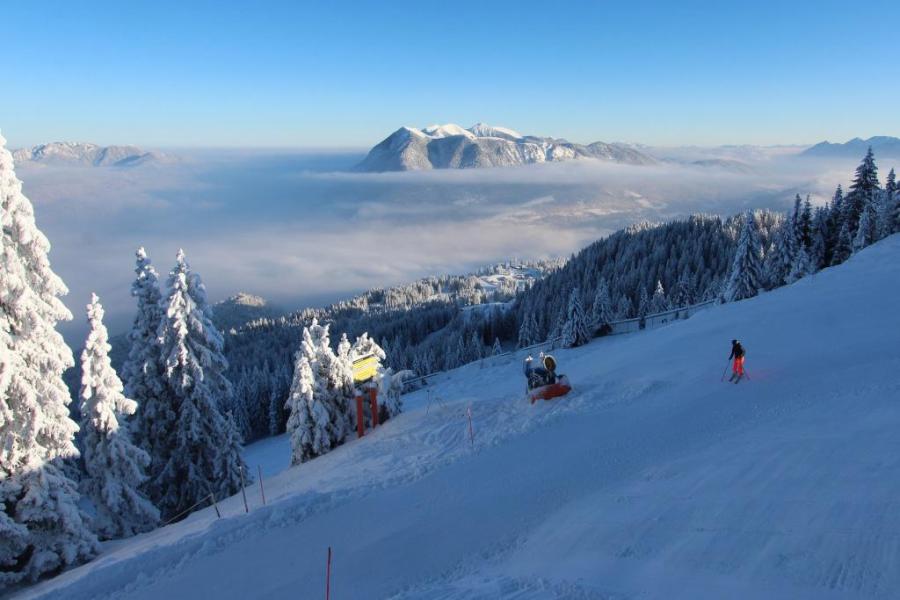
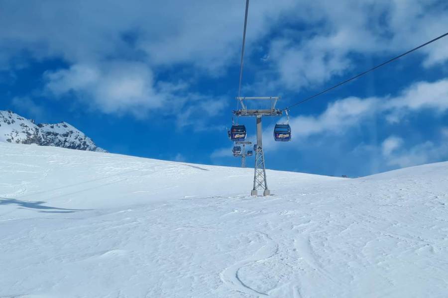
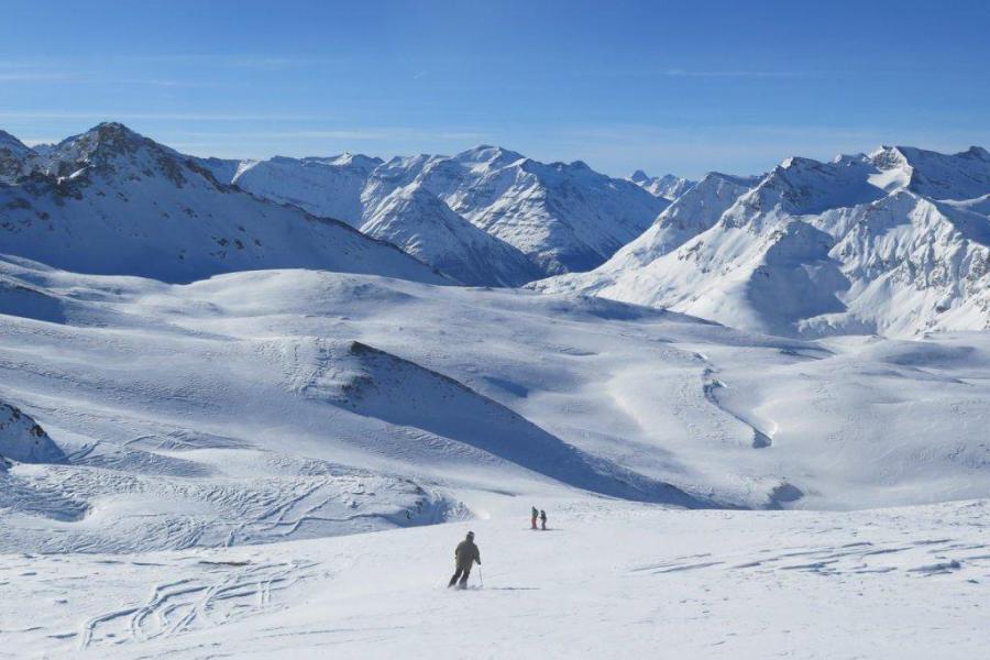 Beautiful weather over the weekend in Val d’Isère. This is the Pays Désert where you can still find some enjoyable snow conditions with the help of a good local ESF ski guide – Photo: ESF Val d’Isere, 28 January 2024
The position of this High to the east of the Alps means that it will be exceptionally mild, at least in the western Alps, with freezing levels as high as 3500m. However, as the week progresses, the High will move towards the west of the Alps drawing in slightly cooler air from the north.
There may be a few light showers or flurries in the northern Alps to end the week but that is a long way off. As for any return to winter, the various weather models are indicating that we could see some much colder and snowier air around the second week in February but it’s still all to play for. Fingers crossed.
Meanwhile, snow conditions in the Alps are very mixed. Snow cover is generally quite thin at lower altitudes, and sometimes non-existent at very low altitudes, especially in the south and west. The pistes are often quite icy too or alternating between ice and slush on slopes exposed to the sun. For the best snow conditions, you need to be in resorts with plenty of high north-facing terrain where there has been less freeze/thaw.
Updated: 11.30am Sunday 28 January 2024 – Spring-like weather in the Alps, especially in the west…
It’s another gloriously sunny day just about everywhere across the Alps today, with just a little bit of low cloud stuck in some of the lower valleys, mostly close to the northern foothills. It will also feel quite warm in the sunshine, especially in the western Alps where freezing levels will reach 3300m or more.
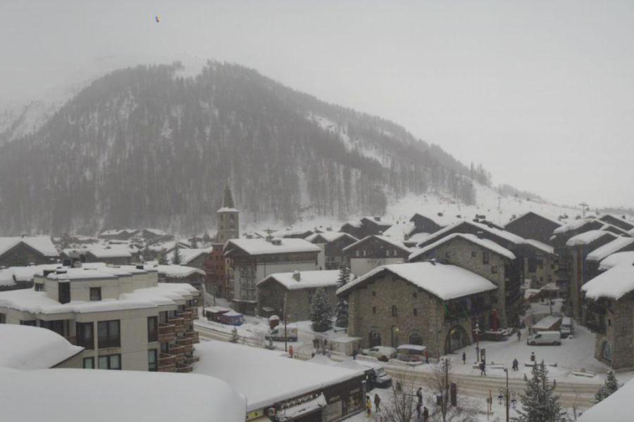
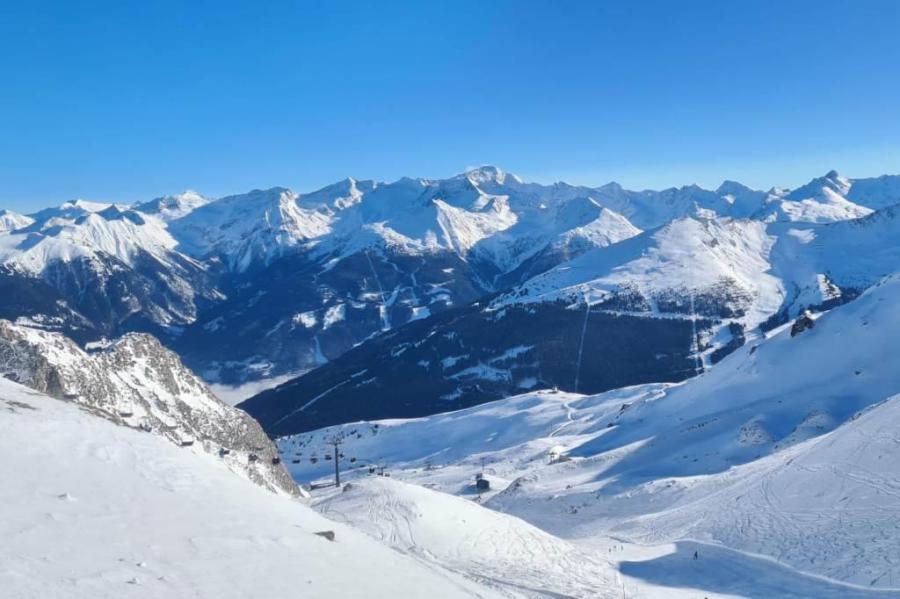
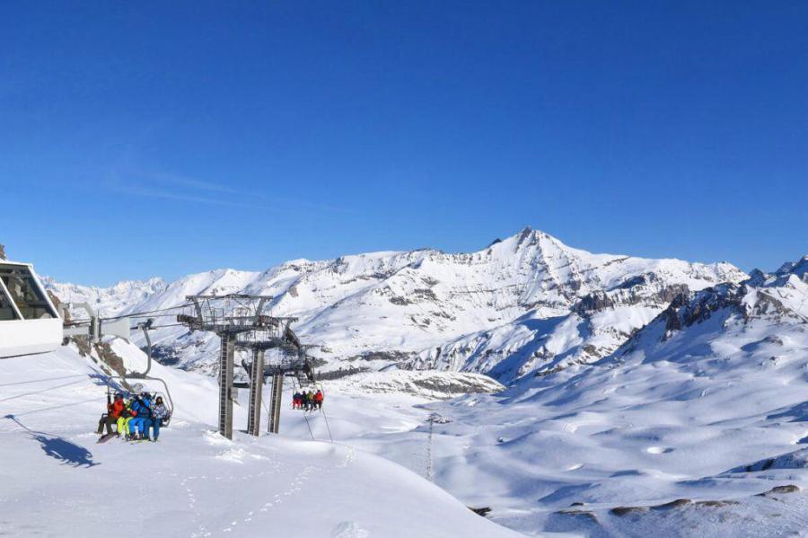 Perfectly sunny across virtually the entire Alps today. This is Val d’Isère – 28 January 2024 – Photo: valdisere.com
High pressure is indeed firmly in control of the weather in the Alps, meaning lots of dry and fine weather over the next few days. The location of the high, centred to the east of the Alps, is also dragging up a very mild southerly airflow.
Snow conditions will be quasi-spring like in many parts today, despite the relatively low sun angle, with some afternoon slush expected on lower slopes, especially on south-facing ones in the western Alps (where it is warmest).
The absence of snow at low altitudes is also becoming increasingly noticeable, with many lower southern and western regions looking more like late March than late January.
Updated: 1pm Friday 26 January 2024 – Weak front approaching the northern Alps…
It’s been a mostly sunny morning in the Alps, but thickening cloud will bring some mostly light precipitation to some northern regions later in the day. The south will stay mostly fine, however, and it will continue to feel mild everywhere.
 Cloud thickening across the northern Austrian Alps, where some rain or snow is expected later today. This is St Johann in Tirol – 26 January 2024 – Photo: foto-webcam.eu
This latest front will bring no more than a dusting of snow above 2000m this evening in the northern French Alps, but 5-10cm in the northern Swiss and Austrian Alps, and as much as 15cm in places. The rain/snow limit will start close to or above 2000m but will fall to 1600-1800m in the Swiss Alps overnight, and as low as 1200m in the northern Austrian Alps.
Fine weather will return everywhere on Saturday, and it should remain sunny and increasingly warm all next week.
The recent mild weather is beginning to take its toll on snow conditions at lower altitudes across the Alps, with an increasingly spring-like feel in many places, especially on lower south-facing slopes.
Updated: 10.20am Thursday 25 January 2024 – Still changeable in the northern Alps…
This morning there is a lot of cloud across the eastern Swiss and Austrian Alps, with showers and snow above about 2000m in Switzerland, and between 1400-1800m in Austria. The southern and western Alps are drier and brighter.
 Solid on-piste snow conditions in the southern Austrian Alps. This is Bad Kleinkirchheim – 25 January 2024 – Photo: foto-webcam.eu
Today’s relatively weak weather front will deliver a few centimetres of snow above 2000m to some northern areas, with as much as 10-15cm at altitude in parts of Austria (e.g. Arlberg).
Friday will start dry and bright for most of the Alps, though further weather fronts will skirt the northern Alps as the day progresses, bringing a few more centimetres of snow here and there (especially in Austria), with a rain/snow limit falling from about 1600-1800m towards 1000-1200m later in the day. The north-western Alps (e.g. French Savoies) will only see very light and patchy precipitation later in the day, and the southern Alps will again stay mostly dry and bright.
Saturday will see a return to fine weather across all parts of the Alps, with only a little nuisance-value cloud at low altitude. This fine and increasingly warm weather will continue on Sunday, and into the first part of next week.
As to snow conditions across the Alps, broadly speaking there is still a lot of snow at altitude in the northern Alps but very meagre snow cover at lower altitudes. Snow depths are generally more modest in the southern Alps, but with more consistent on-piste snow quality thanks to having less volatility in its weather of late.
Updated: 11am Tuesday 23 January 2024 – Remaining mild in the Alps, but changeable in the north…
The weather in the northern Alps remains unsettled. One set of showers (snow 1000-1200m) is currently sitting over Austria, but will clear eastwards this afternoon, while another is due to move into the north-western Alps later this afternoon, but with a rain/snow limit rising to 2000m. In between there will be some sunny spells, as there will be more generally across the southern Alps.
 Snow this morning in Warth am Arlberg, which will clear eastwards later – 23 January 2024 – Photo: warth-schroecken.at
The weather front expected later this afternoon will be much weaker than the last, delivering just a few centimetres of snow at best across some higher parts of the north-western Alps.
The rest of this week will continue in the same vein, staying mild with weak weather fronts occasionally grazing the northern Alps, and the most consistently sunny skies in the southern Alps.
In terms of snow conditions, there is still a lot of snow at altitude in the northern Alps, with over 3m above 2500m in resorts as geographically diverse as La Rosière, Chamonix, Laax and St Anton. Lower down in the northern Alps snow cover is generally more modest, and often patchy at very low altitudes thanks to fluctuating temperatures and intermittent rain.
Most southern Alpine resorts (e.g. Selva, Monte Rosa, Sestriere) are well below par in terms of snow depth, though have been offering more consistent snow conditions over recent days and weeks, at least on-piste, thanks to the less volatile and (crucially) less humid climate of the southern Alps.
Updated: 1.40pm Monday 22 January 2024 – Mild weather in the Alps, with occasional rain or snow in the north…
The Alps are under the influence of a mild south-westerly airflow with (mostly) weak weather fronts set to affect the northern Alps from time to time over the next few days.
 Plenty of snow but a bit damp today at 1600m here in Les Saisies – 22 January 2024 – Photo: lessaisies.com
This lunchtime it is raining close to the north-western foothills of the Alps, with rain and snow due to push slowly east across most of the northern Alps later today and tonight. The rain/snow limit will start at around 1800-2000m but will drop to reach around 1000m overnight.
By tomorrow morning we can expect 2-10cm above 1800m across much of the northern Alps, with as much as 15-20cm at altitude in parts of the northern French Alps (e.g. Flaine, La Rosière). The southern half of the Alps will remain mostly dry.
Early on Tuesday, the north-eastern Alps will see some showers (snow around 1000m), which will die away later. Further west in the northern Alps it will be drier with some bright spells possible for a while before the next weather front brings a little rain or snow to the north-western foothills later in the day. The rain/snow limit will start relatively low but will rise to 2000m or higher on Tuesday evening.
Broadly speaking there remains a lot of snow at altitude in the northern Alps with over 3m above 2500m in resorts as geographically diverse as La Rosière, Chamonix, Laax and St Anton. Lower down in the northern Alps, snow cover is generally more modest, and often patchy at very low altitudes due to the constant fluctuations in temperature and occasional rain.
Most southern Alpine resorts (e.g. Selva, Monte Rosa, Sestriere) are well below par in terms of snow depths, although the less volatile and (crucially) less humid climate of the southern Alps has often made for more consistent skiing conditions in recent days and weeks, at least on-piste.
Updated: 1pm Thursday 18 January 2024 – Unsettled, with rain or snow for much of the Alps…
It’s a mostly cloudy day in the Alps with just a few brighter spells in the far south and south-east (notably the Dolomites). There is also plenty of rain and snow about, heaviest in the north-west where the rain/snow limit is starting at around 1600-1800m but will drop sharply later today and overnight.
 Cloudy in Châtel this lunchtime, where the rain/snow limit is currently around 1500m but forecast to fall sharply later – 18 January 2024 – Photo: chatel.com
Tonight, the bulk of the precipitation will move towards the eastern Alps where it will linger for a while tomorrow morning before it fizzles out. The rain/snow limit will fall to very low levels, first in the northern Alps then later further south.
Friday will see sunnier skies in the western Alps, pushing gradually eastwards, though it will feel noticeably colder everywhere.
By tomorrow morning, 48-hour snowfall totals above 2300m should exceed 50cm in some north-western areas (e.g. Tignes), with many other parts of the Alps seeing at least a bit of snow. However, some northern and western parts of the Alps will have seen quite a lot of rain damage lower down, especially in the French and western Swiss Alps, even if it ends up being disguised overnight by the very low snowline forecast at the end of this storm.
Updated: 9am Wednesday 17 January 2024 – Rain and snow in the Alps!
A storm is currently in progress across the western Alps, with a warm front having arrived last night introducing an increasingly mild south-westerly airflow. Later tomorrow a cold front will send temperatures tumbling again, but by this point there will have been a lot of rain at lower altitudes, at least in the north-western Alps.
 Snow turning to rain early this morning in Tignes – 17 January 2024 – Photo: tignes.net
The rain/snow limit will reach 2200-2600m today across some western regions (e.g. French Alps) but will remain lower for longer in the more sheltered internal valleys (e.g. Swiss Valais). Precipitation intensity will tend to fade for a time during the middle of the day before intensifying this evening, with the snowline descending to 1700-1900m overnight.
The eastern Alps (e.g. most of Austria, Dolomites) will be less affected by this storm today but will see some precipitation tonight with a rain/snow limit more in the region of 1600-1900m.
Tomorrow (Thursday) the focus for the heaviest precipitation will tend to move back towards the north-western Alps with a rain/snow limit initially around 1500-1800m but dropping during the day to reach 400m or so by evening. The milder air will hang on for longest in the south-eastern Alps, although any precipitation here will become patchier and lighter.
All in all, it’s clearly a very complex situation in the Alps over the next 48 hours. Above 2500m we can expect storm totals of well over 50cm across some parts of the Alps by the end of Thursday, especially in the French Alps. However, it will also be the French (and western Swiss) Alps that will see the most rain damage lower down. Further east, there will be less snow albeit with a slightly lower rain/snow limit.
Friday will be a calmer day all round but cold, and it will then start to turn warmer again over the weekend, and especially into next week.
Updated: 11.20am Monday 15 January 2024 – Fresh snow for some northern parts of the Alps…
It’s mostly cloudy this morning across the north-western Alps with snow showers here and there and a rain/snow limit ranging from about 1000m in the French Alps to 400m in the eastern Swiss/far western Austrian Alps.
 Light snow today in Val d’Isère where storm totals could reach 15cm by the end of the day – 15 January 2024 – Photo: valdisere.com
This storm started late yesterday, and by tonight will have delivered snowfall totals of 5-15cm across the north-western Alps, with the heaviest snow having fallen in the French Savoie (e.g. Val d’Isère).
By contrast, the southern and eastern Alps are drier today, with the best of the sunshine across the south-east (e.g. Dolomites).
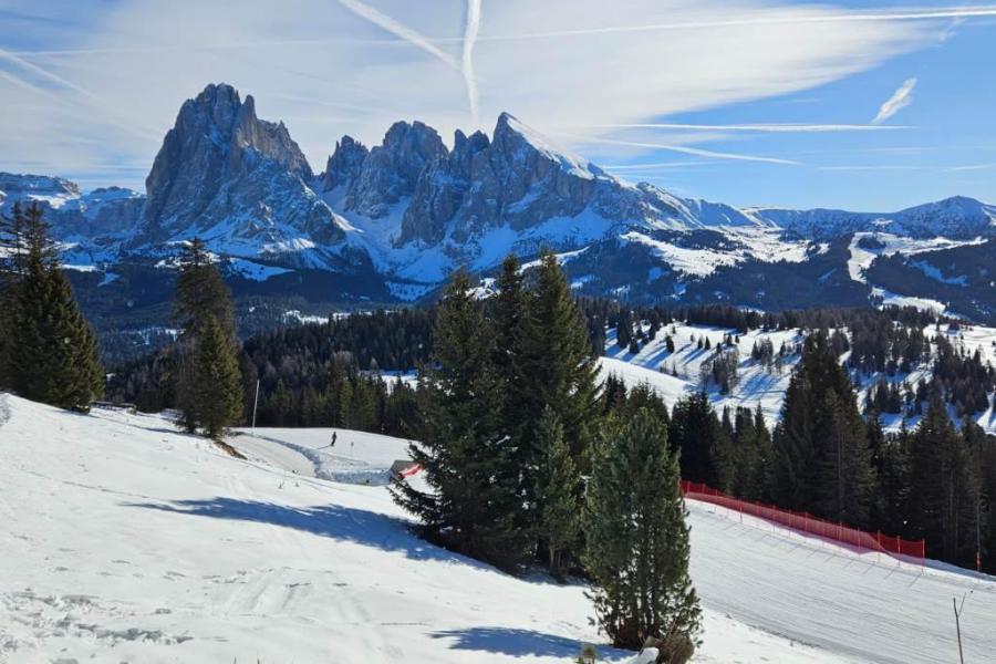 Mostly blue skies and lots of sunshine in the Dolomites today. This is the Alpe di Siusi – 15 January 2024 – Photo: Drew Tetlow
After a mostly dry and fine day tomorrow, the next storm will reach the western Alps on Tuesday night and continue to influence the weather until Thursday.
This storm will be more active and more complex, with the potential for a lot of snow at altitude but also some rain to 2000m or higher for a time on Wednesday, especially in the north-western Alps. We will bring you more details on this storm tomorrow…
Updated: 9am Thursday 11 January 2024 – Cold and mostly sunny in the Alps today…
It’s another cold but mostly fine day in the Alps, with lots of sunshine at altitude. That said, this morning there are some stubborn areas of fog/low cloud trapped in valley bottoms, especially near the foothills, and some areas of high cloud circulating around the western Alps.
 Cold and sunny at altitude in Austria today. This is Heiligenblut in the central-southern Austrian Alps – 11 January 2024 – Photo: foto-webcam.eu
This relatively quiet period of weather will continue over the next few days but will begin to break down over the weekend and more especially early next week, with the arrival of some weather fronts from the north. These new fronts are likely to bring a bit of snow to low altitudes across some northern regions, but no more than that at this stage.
In the meantime, snow conditions remain good across most of the Alps, thanks to last weekend’s snow and the ensuing cold and more stable weather. The deepest snow and best off-piste opportunities are still to be found at altitude and in the northern Alps.
Snow depths remain on the modest side lower down and more generally in the southern Alps, though there is still lots of excellent piste-skiing here as well.
Updated: 10am Tuesday 10 January 2024 – Temperatures remain cold in the Alps…
A cold but mostly dry easterly airflow continues to dominate the weather in the Alps, delivering just a few flurries close to the western foothills (e.g. near Geneva). Elsewhere, cloud cover will again be variable, though many places will see some good spells of sunshine, especially at altitude.
 A typical scene in the Alps today - cold and bright with snow on the ground to low levels. This is St Johann in Tirol – 10 January 2024 – Photo: foto-webcam.eu
Yesterday the snow flurries forecast for the extreme western Alps were heavier than expected, with 16cm falling in the centre of Annecy, for example. This snow didn’t make much progress into the Alps but gave a very useful top-up to some of the foothill areas, including the Vercors (just west of Grenoble) and the Jura (just north of Geneva).
More generally across the Alps there hasn’t been any significant snow since the weekend, though the cold temperatures mean there has been very little if any snow melt, even at low altitudes, so it is still a wintry-looking scene for most.
Needless to say there is lots of good skiing on offer across the Alps, with the deepest snow and best off-piste opportunities still to be found at altitude and in the northern Alps. Snow depths remain on the modest side lower down and more generally in the southern Alps, though there is still lots of excellent piste-skiing here as well.
The next significant snow is likely to be next week and arriving from the north-west, though it is too early to say how heavy or widespread this might be.
Updated: 10am Tuesday 9 January 2024 – Cold with plenty of good skiing across the Alps…
With high pressure over north-western Europe and low pressure over the Mediterranean, the Alps are currently under the influence of a chilly easterly airflow. This will be mostly dry, with the one exception being the western foothills of the Alps (e.g. resorts west of Grenoble) where some flurries may lead to small accumulations at low altitudes.
 Cold and snowy this morning in the Bavarian resort of Garmisch, close to the German-Austrian border – 9 January 2024 – Photo: foto-webcam.eu
There will be variable cloud cover elsewhere in the Alps, with the best of the sunshine at altitude, and lower altitudes most likely to stay grey. Whatever the case, it will feel cold just about everywhere. For the rest of the week the weather pattern will remain broadly similar, with variable cloud cover and relatively cold temperatures but little, if any, new snow.
Following last weekend’s snowfalls and with colder weather now established across the Alps, snow conditions are generally pretty good across most of the Alps right now.
However, snow depths remain modest at lower altitudes in most areas meaning that, although it may look wintry, off-piste opportunities remain limited lower down. The deepest snow is at altitude across the northern half of the Alps (e.g. La Plagne, La Rosière, Engelberg, St Anton, Sölden) all of which have close to over above 3m of settled snow up top.
Updated: 10am Monday 8 January 2024 – Snow conditions are much improved across most of the Alps…
Weathertoski is just back from Bad Gastein where it was snowing when we left yesterday and continued to snow throughout our journey down to Salzburg airport.
 Cold and snowy across many parts of the Alps right now. This is Turracher Höhe in the central-southern Austrian Alps – 8 January 2024 – Photo: foto-webcam.eu
Today there is a lot of cloud across the Alps with just a few sunny breaks here and there. Most regions will be dry, but a few light flurries are still possible here and there. It will be cold everywhere, especially in the northern and north-eastern Alps where temperatures will struggle to get above freezing even in the lowlands.
Snow conditions have improved significantly in many areas following this most recent storm, which started on Friday and has only just petered out across some northern fringes of the Alps. Snowfall totals from this storm generally haven’t been that huge (typically 20-50cm) but, with plummeting temperatures, snow has fallen to increasingly low levels, and it finally looks like the middle of winter in most resorts.
Over the next few days, except for a few flurries here and there, many areas will be dry with variable cloud cover. It will be on the cold side though which will help preserve any newly fallen snow, even at lower altitudes.
Updated: 7am Saturday 6 January 2024 - Fresh snow for many parts of the Alps!
Weathertoski is currently in Bad Gastein where it is snowing this morning with a temperature just below freezing.
 Snow falling this morning in Bad Gastein, with light snow forecast to continue for much of the weekend – 6 January 2024 – Photo: weathertoski.co.uk
We already have a few centimetres of fresh snow on the ground in Bad Gastein at the time of writing and, with it forecast to continue to snow lightly/moderately for much of the day, another 5-10cm is possible here by the end of the day.
Most other parts of the Alps have also seen or are seeing some fresh snow from this latest storm, with the rain/snow limit continuing to fall today to around 500m in the northern Alps, and 800m later in the southern Alps. It will remain wintry tonight and tomorrow with snow showers to very low levels almost anywhere, but increasingly favouring the northern foothills of the Alps. The wind will also increase, becoming very strong at altitude on Sunday.
By the end of tomorrow we can expect 10-20cm of snow to have fallen across much of the Alps, though with less in some south-western parts (e.g. Pila, Milky Way) and a bit more across some northern regions.
Snow conditions are obviously improving across most of the Alps even if snowfall totals from this storm are not especially high overall. As any snow is falling to increasingly low levels, it will also look wintry right down to low altitudes by tomorrow, especially in the northern Alps.
Updated: 4.45pm Thursday 4 January 2024 - Great snow conditions at altitude in the Gastein valley today!
Weathertoski is currently in Bad Gastein where it was partly cloudy with the odd very light flurry this morning, but mostly sunny this afternoon with a freezing level around 1300m.
 Fabulous snow conditions at altitude in the Gastein valley today. This is Sportgastein – 4 January 2024 – Photo: weathertoski.co.uk
Today we skied in Sportgastein, the highest and most remote ski area in the Gastein valley. The snow was excellent with packed powder on all but the very lowest part of the ski area, which was a bit more hard-packed but still grippy with no ice.
 Empty slopes and fabulous grippy pistes in Sportgastein today – 4 January 2024 – Photo: weathertoski.co.uk
Elsewhere in the Alps, there has been plenty of fine weather around today with the cloudiest conditions along the northern fringes of the Austrian Alps. The next storm will arrive from the south-west tomorrow, merging with fronts arriving from the north-west.
Just about all parts of the Alps are expected to benefit from fresh snow at some point between Friday and Sunday, during which period it will also turn colder, with any snow falling to very low levels by the end of the weekend.
As for snow conditions, they remain a bit mixed across the Alps right now. There is generally still lots of good skiing around, particularly at altitude and across the northern half of the Alps, though some weaknesses remain, with below average snow cover across most of the southern Alps and more generally at lower altitudes.
Updated: 4.50pm Wednesday 3 January 2024 - Lovely day in the Gastein valley today, but a new storm is now approaching the western Alps…
Weathertoski.co.uk is currently in Bad Gastein where the weather was mostly sunny today with freezing levels around 1800m.
 Beautiful day and pretty good snow conditions in Bad Gastein today – 3 January 2024 – Photo: weathertoski.co.uk
Snow conditions here in the Gastein valley are generally pretty good, with mostly hard-packed but grippy pistes, and some softer chalkier snow in places. Given the volume of traffic in recent days, there were also some icier patches lower down, especially on shadier slopes, as will be the case in most other resorts in the Alps right now.
All in all, it was a great day’s skiing, made all the better by uninterrupted sunshine and particularly good visibility.
Elsewhere in the Alps there has been plenty of fine weather today, though the next storm has already hit the far western Alps at the time of writing and will continue to move east overnight. This storm will mostly affect the northern half of the Alps, with the heaviest falls (typically 10-15cm) due in the northern French and western Swiss Alps.
By the time it reaches Austria overnight, the storm will be less potent, delivering just a few centimetres here and there, mostly close to the northern edge of the Alps. The southern Alps will stay mostly dry.
This evening and tonight the rain/snow limit will be around 1400-1700m for a time in the north-west, but a bit lower further east, before falling back towards 1000m everywhere overnight.
After something of a reprieve on Thursday, another storm will move in from the south-west late on Friday. This will merge with other weather fronts coming down from the north-west on Saturday and Sunday, meaning that all parts of the Alps are in with a good chance of significant snow by the end of the weekend, by which time it will also have turned much colder.