

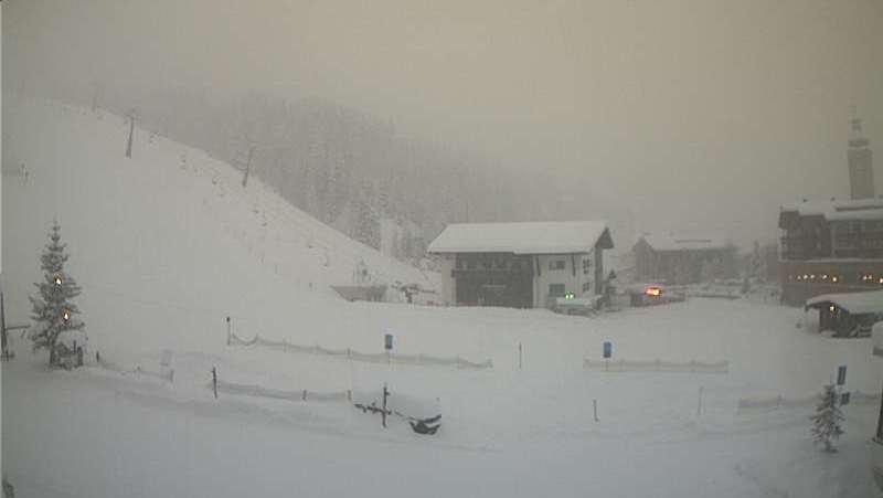
Updated: 9.50am Tuesday 31 January 2017 – Mild with further rain/snow, mostly across the northern Alps
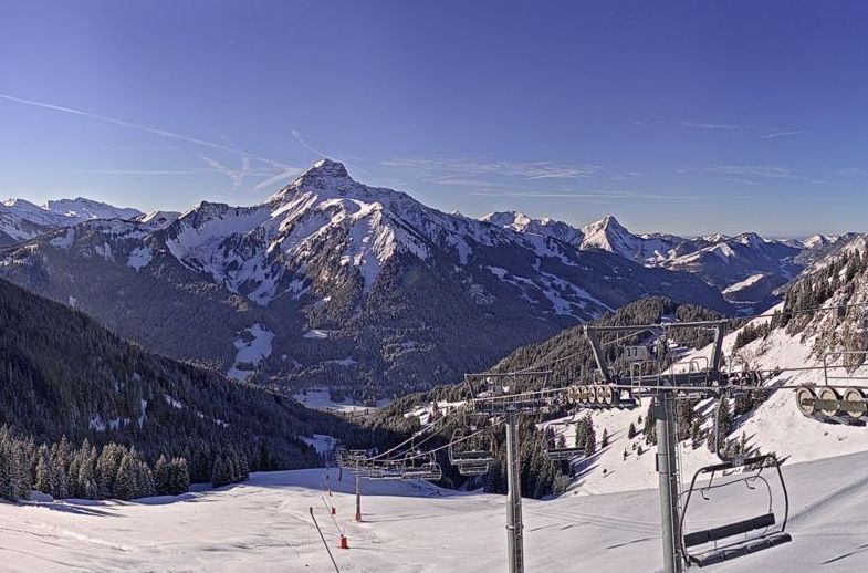
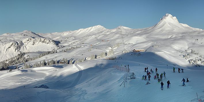
It wasn’t properly picked up on the charts until Saturday, but the “little” storm currently affecting the northern half of the Alps is proving to be more than an irritation at low altitude.
 Fresh snow at altitude in Engelberg – 31 January 2017 – Photo: engelberg.ch
On Monday we saw the first showers reach the northern foothills of the Alps early in the day, with rain and snow becoming more persistent by the afternoon, lasting on and off all night.
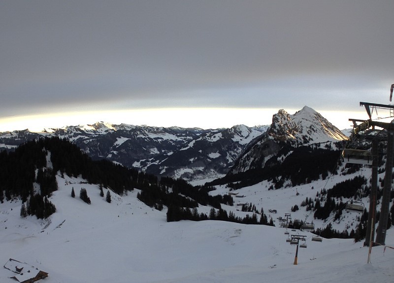
The bad weather will continue today across much of the northern Alps, with the heaviest precipitation in eastern Switzerland and western Austria. The rain/snow limit will be between 1700m and 2000m in the north-western Alps (e.g. Chamonix, Portes du Soleil, Jungfrau region) but closer to 1500m in western Austria (e.g. Lech, St Anton). Above 2000m these regions can expect 15-30cm of snow quite widely by the end of the day, with up to 50cm very locally - more than originally forecast.
The southern half of the Alps will see again see little if any snow, with variable cloud and the odd sunny spell.
Snow conditions are now highly variable across the Alps with poor snow quality at low altitude in the north, due to mild temperatures and (in places) rain. As we mentioned earlier, however, there will be fresh snow above 1500-2000m today, which will help the higher areas once the weather improves. Snow conditions (on-piste at least) are a little more consistent today in the south, which has avoided most of the precipitation.
Updated: 8.10am Monday 30 January 2017 - Very mixed weather and snow conditions early this week
The weather situation in the Alps has changed quite markedly since we last reported, with the unexpectedly rapid development of a small storm over northern Europe. This storm will trail its fronts across the northern Alps later today and tomorrow, bringing some snow at altitude but also some rain lower down.
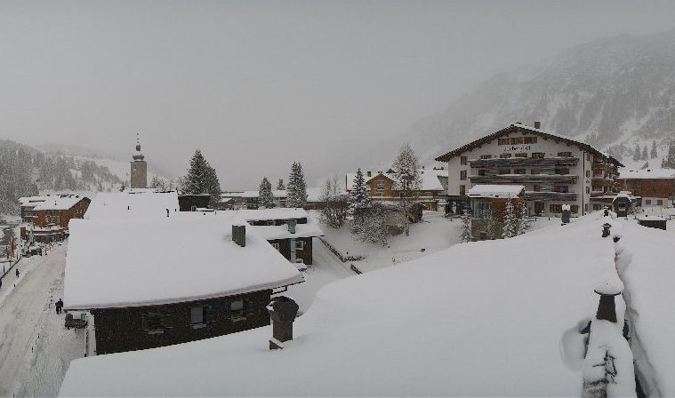
 Clouding over in the Austrian Vorarlberg this morning ahead of the expected snow (and rain). This is Mellau – 30 January 2017 – Photo: mellau.at
Any precipitation will be light and patchy in nature today, turning a bit heavier and more persistent tomorrow, especially in Austria. The rain/snow limit may start quite low in places, especially in the more sheltered valleys, but with milder air in the mix will rise to 1500m or even higher (highest in the north-western Alps).
Snowfall totals will be mostly modest – just a few cm at altitude in the northern French Alps (e.g. Chamonix), and perhaps 20cm or more in some parts of Austria (e.g. St Anton) by tomorrow afternoon. The southern Alps will see little or no precipitation.
Snow conditions are very mixed across the Alps early this week, generally best at altitude across the south-western Alps (e.g. Sestriere, Montgenèvre) where there was some snow over the weekend. In low altitude resorts the snow quality is likely to suffer over the next few days due to mild temperatures and, in places, some rain.
Updated: 10am Saturday 28 January 2017 - Fresh snow for some south-western parts of the Alps, elsewhere the wait continues
There is a lot of cloud and some snow showers in the south-western Alps this morning. This cloud has spilled north to affect some parts of the northern French Alps and Switzerland. The eastern Alps (i.e. Austria and the eastern Italian Alps), however, are mostly sunny.
 Fresh snow in Sestriere this morning – 28 January 2017 – Photo: vialattea.it
Fresh snow from this disturbance has been limited to parts of the southern French Alps closest to the Italian border (e.g. Isola 2000) and the Piedmont (e.g Sestriere, Prato Nevoso). Snowfall totals have generally been quite modest (2-15cm) but there have been heavier falls in parts of the southern Piedmont (e.g. Limone), which may total as much as 40cm when all is said and done later today.
There will be lots of dry weather across the Alps next week, at least early on, with just the odd shower or flurry here and there. It will also be much milder than last week, which will start to put pressure on the generally shallow snow pack across the Alps, especially on lower slopes exposed to the sun.
 Sunny in the eastern Alps today. This is Hochkönig – 28 January 2017 – Photo: hochkoenig.at
So we can be fairly certain that we won’t see any widespread or significant snow until next weekend at the earliest. However, most long range charts are pointing towards a proper pattern change (to serious snow) in the week leading up to half term. It’s not a given yet but fingers crossed!
In the meantime, there is still plenty of good piste skiing to be had, though as we mentioned earlier, it is turning milder which will start to expose the less than impressive snow depths in some places over the next few days.
Updated: 7.40am Thursday 26 January 2017 - Slow changes
The weather in the Alps will remain fine in most areas today, but slow changes are afoot, starting in the south-west.
 Dawn in the Portes du Soleil – 26 January 2017 – Photo: portesdusoleil.com
There is still quite a lot of low cloud around today, especially close to the foothills of the Alps. At altitude, however, it is mostly sunny. The one exception will be the far south-western Alps where there will be more in the way of cloud, and one or two light snow flurries here and there.
Over the next couple of days the weather pattern will remain broadly similar except that any showers in the southern French and western Italian Alps will become a bit more widespread, from near the Mediterranean (e.g. Isola 2000, Limone), northwards through the Milky Way and up into the Aosta valley (e.g. Cervinia).
Snowfall totals will generally remain modest – just a few cm here and there – but could locally be significant in the extreme south (e.g. Limone). A little snow may also spill over the Swiss border into the higher areas of Zermatt and Saas-Fee, perhaps even into the eastern Savoie in France (e.g. Val d’Isère). The vast majority of the Alps will stay dry, however, with plenty of sunshine in the north and east. It will gradually turn milder, especially in the north where the Foehn will blow from later today through to Saturday.
Early next week will be mostly dry and relatively mild with just a few showers or flurries possible in some southern parts of the Alps.
As for snow conditions, they remain largely good for the time being on-piste but much more limited off-piste. That said, it is still possible to find some powder at altitude in some northern parts of the Alps with a bit of effort and a good guide. It is worth noting, however, that snow depths remain way below par across most parts of the Alps which will create problems later in the season if we don’t seen more widespread and heavy snow soon.
Updated: 8.50am Tuesday 25 January 2017 - Some snow in the south-western Alps over the next few days
There will be a few light snow flurries in the south-western Alps today (e.g. Isola 2000, Limone, Sestriere) but these won’t amount to very much. Further north and east it will again be mostly sunny, at least above any stubborn low cloud.
 Plenty of sunshine in the northern Alps today, at least above any fog/low cloud. This is Berchtesgaden in Bavaria, close to the Austrian border – 25 January 2017 – Photo: berchtesgadener-land.com
Occasional snow flurries will continue over the next few days in the south-western Alps, becoming a bit heavier and more widespread for a time on Friday and Saturday, affecting many southern French and western Italian resorts, and perhaps even spilling into the far south/south-west of Switzerland. On the whole, however, snowfall totals will be modest (just a few cm here and there) with any significant falls very localised.
The vast majority of the Alps will see very little (if any) snow, with the north and north-east (e.g. Austria) missing out completely. What’s more, the Foehn will start late on Thursday (lasting until Saturday) which will significantly raise the temperature across the northern half of the Alps.
In the meantime, on-piste snow conditions remain pretty good across most of the Alps, even if artificial snow is still playing a significant role in places, especially in the southern Alps (e.g. the Dolomites).
Serious off-piste opportunities are mostly confined to the northern Alps and you will almost certainly need a good guide (or expert local knowledge) to find any powder.
Updated: 7.50am Tuesday 24 January 2017 - Mostly sunny at altitude
It’s another dry and mostly sunny day in the Alps, at least above any low cloud or fog that is plaguing some valleys, especially close to the foothills. It will generally be a little colder than yesterday though will still feel quite pleasant in the sun, especially on south-facing slopes.
 Another beautiful day dawns in Kitzbühel – 24 January 2017 – Photo: kitz.net
The next few days will remain mostly dry, although some snow showers are likely in the far south-western Alps later in the week (e.g. Isola 2000, Prato Nevoso).
Looking a bit further ahead, there is hope of some more widespread and significant snow across the Alps next week, but that is still a long way off - so watch this space!
On-piste snow conditions remain very good across most of the Alps, even if artificial snow is still playing a significant role in places, especially in the southern Alps.
Serious off-piste opportunities are mostly confined to the northern Alps and you will almost certainly need a good guide (or expert local knowledge) to find any powder.
Updated: 9.50am Monday 23 January 2017 - A mostly dry week ahead
There is a little fresh snow in the Alps this morning, but only in the far south-west, including resorts such as Isola 2000 and Limone. No significant new snow is expected anywhere in the Alps this week.
 A little fresh snow for the far south-western Alps this morning. This is Limone in the Italian Piedmont – 23 January 2017 – Photo: ilmeteo.it
Any early flurries today will die away from the extreme south-western Alps. Some cloud has also spilt northwards ahead of this system, affecting other parts of the western Italian and French Alps. However, for the vast majority of regions it will be another sunny day. After a very cold start it will feel relatively pleasant at altitude, with maximum temperatures not far off 0°C at 2000m.
On-piste snow conditions remain pretty good across the Alps, though many southern regions (e.g. the Dolomites) are still almost entirely dependent on artificial snow. Off-piste conditions are more variable. You can still find some powder in the northern Alps with the help of a good guide, but it is becoming increasingly difficult.
Updated: 11.05am Sunday 22 January 2017 - A little snow for the extreme south-western Alps otherwise still fine
We have a few snow showers in the far south-western Alps today (e.g. Isola 2000, Limone) but this snow will be very localised and the vast majority of the Alps will be dry and sunny.
 Another beautiful day in Austria. This is the Mölltal glacier – 22 January 2017 – Photo: gletscher.co.at
Next week will also be mostly dry and sunny, with just the odd flurry still possible on Monday and Tuesday in the far south-west. Nights will be cold but it will feel quite pleasant in the sunshine during the day.
Snow conditions remain pretty good on-piste, even if artificial snow is still crucial in much of the southern half of the Alps (e.g. the Dolomites). Off-piste conditions are more mixed – it is still possible to find some powder in the northern Alps with the help of a good guide, but it is becoming increasingly difficult.
Updated: 8.15am Saturday 21 January 2017 - Mostly fine, a little snow in far south-west tomorrow
High pressure is still in control of the weather in the Alps. A weak disturbance will bring a little snow to the extreme south-western Alps on Sunday and Monday, but the vast majority of regions will stay dry – not just this weekend but for much of next week too.
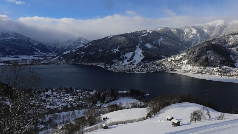
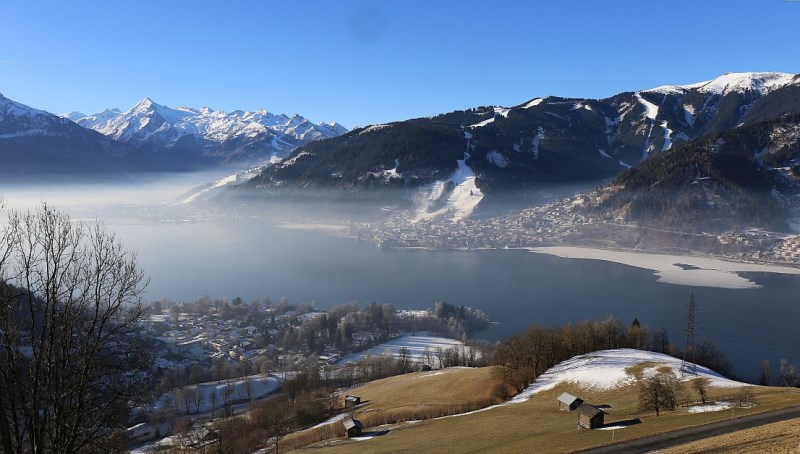
 Fog over the lake in Zell-am-See early this morning – 21 January 2017 – Photo: zellamsee-kaprun.com
Today will be mostly sunny. After a very cold start, it will feel quite pleasant in the sunshine later in the day, particularly on south-facing slopes. On-piste skiing conditions will remain largely excellent. Off-piste conditions will be more mixed but, with a good guide, it is still possible to find powder in the northern half of the Alps.
Tomorrow the far southern French and south-western Italian Alps will see some snow (e.g. Isola 2000, Limone, Prato Nevoso). Some high cloud will spread north ahead of it, but the vast majority of the Alps will remain dry and sunny.
Apart from a few lingering flurries in the far south-western Alps on Monday, most of next week will also be fine, with cold nights and relatively mild feeling days, particularly in the sunshine.
Updated: 9.30am Thursday 19 January 2017 - Mostly sunny, slightly less cold
There’s a magnificent day in store for most of the Alps today. After a very cold start, temperatures will recover slightly this afternoon, but will remain below freezing at most skiing levels. All in all, a pretty good day for anyone lucky enough to be hitting the slopes.
 Fabulous snow conditions in Fieberbrunn, Austria – 19 January 2017 – Photo: bergbahnen-fieberbrunn.at
This fine weather will continue for the foreseeable future in most parts of the Alps. However, over the weekend (particularly on Sunday) cloud will increase in the south-western Alps with some snow in places, especially close to the southern border regions between France and Italy (e.g. Isola 2000, Limone, Prato Nevoso).
Some snow may also creep a little further north to affect the Milky Way, Val d’Isère/Tignes, and even some Aosta resorts such as Pila, but there is still lots of uncertainty over this.
In the meantime, there is lots of good piste skiing to be had across the Alps, made all the more enjoyable by the fine weather. There are also plenty of off-piste opportunities, mostly in the northern half of the Alps. However, the avalanche risk remains considerable, so a good guide is always highly recommended.
Updated: 9.40am Wednesday 18 January 2017 – Mostly sunny but very cold
It’s a mostly fine but very cold morning in the Alps, with temperatures -20°C or lower in some valleys! Expect plenty of sunshine on the slopes today but watch out for some stubborn low cloud close to the northern fringes of the Alps, especially in Switzerland and Austria.
 Fabulous snow conditions in the Montafon area in Austria right now – 18 January 2017 – Photo: montafon.at
It will continue mostly sunny but still very cold for the rest of the week, turning a bit milder this weekend. On Saturday, and especially on Sunday, some snow showers will affect the far south-western Alps (e.g. Milky Way, Prato Nevoso, Limone, Isola 2000), possibly even creeping over the French border into the likes of Val d’Isère and Val Cenis. However, most of the Alps will remain dry.
On-piste snow conditions are still generally excellent. Off-piste there are also plenty of opportunities in the northern half of the Alps, though the dangers remain considerable and a good guide is always recommended. Further south, with some exceptions, most resorts are still heavily reliant on artificial snow, which means that you generally have to stay on the beaten track. Exceptions are mostly in the west, including areas such as the Monte Rosa region and Cervinia.
Note that while skiing conditions are generally good right now, snow depths are still considerably below where they should be in most areas for mid-January, with no widespread heavy snow on the cards for quite some time.
Updated: 10.15am Tuesday 17 January 2017 - Good skiing conditions, especially on-piste
There are a few light snow flurries across parts of the eastern Swiss and Austrian Alps this morning. For most, however, it is dry, cold and sunny. This sunny weather will extend to just about all areas from tomorrow onwards, perhaps with the exception of the far south-western Italian Alps (e.g. Limone) where a few light snow showers are possible.
 Magnificent conditions in the Combloux/Megève area today – 17 January 2017 – Photo: combloux.com
Snow conditions are generally good across the Alps right now, especially in the north where the snow is freshest. That said, snow depths are still below where they should be in most areas and, while off-piste opportunities are improving, there are still complications – partly due to the wind blown nature of the new snow (especially at altitude) and partly due to the new snow falling on thin or even non-existent bases (especially at lower altitudes). Either way, the dangers are considerable and taking a good guide is always strongly recommended!
The southern Alps have seen less snow than the north in recent days, with many resorts still highly dependent on artificial snow (e.g. the Dolomites), even if it does look a bit more wintry. The deepest natural snow cover in the southern Alps remains at altitude in the west (e.g. Cervinia, Monte Rosa).
Updated: 9.30am Monday 16 January 2017 - Very cold, further flurries in the north-eastern Alps
The Alps are under the influence of a bitterly cold north-easterly airstream which is still bringing some flurries to the eastern Alps, notably Austria (away from the south) but also parts of eastern Switzerland. These flurries will be mostly light with snowfall totals in the region of 2-10cm, perhaps a little more here and there. For most of the Alps, however, it will be dry with increasing amounts of sunshine the further south and west you are.
 Perfect snow conditions yesterday in Val Thorens – 15 January 2017 – Photo: facebook.com/ValThorens.resort
It will remain cold all week with further flurries in the east (mostly in Austria) to start with. Otherwise there will be lots of sunshine, extending to all areas from mid-week onwards.
Snow conditions have been transformed across the northern half of the Alps over the last week or so and are now excellent, at least on-piste. Off-piste opportunities are also increasing though avalanche danger remains high, so taking an experienced guide is essential.
 Looking very wintry in Megève this morning – 16 January 2017 – Photo: megeve.com
Snow conditions have been transformed across the northern half of the Alps over the last week or so and are now excellent, at least on-piste. Off-piste opportunities are also increasing though avalanche danger remains high, so taking an experienced guide is essential.
In the southern half of the Alps snow cover is less consistent. Some areas, particularly in the south-west (e.g. Cervinia, Monte Rosa region, Sestriere) have good natural cover. Other areas, especially further east (e.g. Dolomites) are more reliant on artificial snow even if it does now look more wintry. Either way, conditions on-piste at least, are also very good.
Updated: 11.20am Sunday 15 January 2017 – While the snowfall is easing, the cold is intensifying!
The heaviest of the snowfall is now over but there are still some flurries close to the northern fringes of the Alps today, especially in Switzerland and Austria, giving a few more centimetres here and there. For the bulk of the Alps, however, it will be sunny today (especially in the south) though bitterly cold at all altitudes.
 Trying to brighten up in Mellau in the Austrian Vorarlberg – 15 January 2017 – Photo: mellau.at
It will remain very cold all week with a few flurries here and there to start with (mostly in the north) but, generally speaking, there will be quite a lot of sunshine in most regions. By mid-week this sunny (but still bitterly cold) weather should extend to all areas.
Needless to say, snow conditions have been transformed in the northern and especially the north-western Alps over the last few days, with cold powdery snow at all levels.
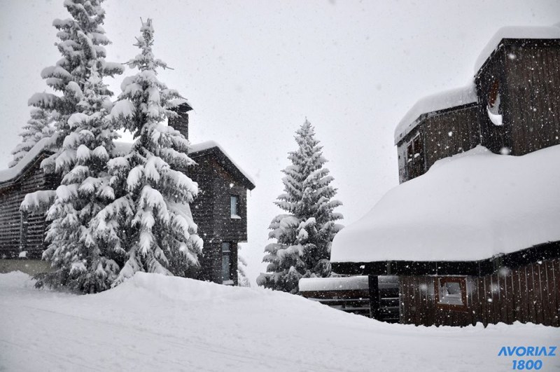 Snow falling in Avoriaz yesterday – 14 January 2017 – Photo: avoriaz.com
However, the off-piste situation remains complicated, partly because of the wind, partly because of the surface that all this new snow has been falling on – either on a thin and icy base (which means it the snow is poorly bonded and unstable) or on no base at all (meaning potential obstacles under the snow). Always take an experienced guide!
 Sunny skies and fresh snow in Méribel today – 15 January 2017 – Photo: merinet.com
Some southern Alpine resorts (e.g. Bormio) have also seen some new snow, but generally in more modest quantities with many resorts still heavily reliant on man-made efforts.
Despite this there will also be some excellent piste skiing here over the coming days, though off-piste opportunities remain much more limited than further north.
Updated: 9am Saturday 14 January 2017 - Lots more snow for the northern Alps
There has been plenty more snow across the northern Alps in the last 24 hours, heaviest again in the north-west - from the northern French Alps (e.g. 3 Valleys, Grand Massif, Portes du Soleil) through Switzerland (e.g. Villars, Jungfrau region, Engelberg, Flims) and into western Austria (e.g. Lech, St Anton). These regions have already seen 40-70cm of new snow from this storm (locally 100cm+), with more due today.
 Lots of fresh snow in Val d’Isère this morning – 14 January 2017 – Photo: radiovaldisere.com
Today snow showers will continue across the northern half of the Alps, heaviest in the central and eastern Swiss Alps as well as western Austria. The southern side of the Alps will see little if any snow, but more in the way of sunshine.
Sunday will be similar though snow flurries will be increasingly confined to the north-eastern Alps. Next week will see a few snow showers here and there but most places will be dry with sunny spells but extremely cold temperatures.
 Blizzard in progress in Lech – 14 January 2017 – Photo: lech-zuers.com
Snow conditions have improved immeasurably across the northern half of the Alps over recent days though the off-piste situation remains complicated – not least due to the very windblown nature of the snow. Always take a good guide!
The southern Aps have also seen bits and pieces of snow over recent days but generally in much more modest quantities, with many areas (e.g. the Dolomites) still heavily reliant on snow-making.
Updated: 9.40am Friday 13 January 2017 - Lots of snow in the north-western Alps
As expected, there is a lot of fresh snow across the north-western Alps this morning - with 35cm reported in Val Thorens at 8am this morning and 40cm at altitude in Flaine, for example. Lower down it did rain to 1500m for a time yesterday evening, but the colder air has now dug in and snow is falling at all skiing levels.
 Big snowfalls in the northern French Alps with plenty more to come. This is La Plagne – 13 January 2017 – Photo: facebook.com/laplagne
Many (but not all) southern and eastern Alpine regions have also seen at least a little new snow (e.g. Sestriere, Dolomites) but it is the north-west that has had the lion’s share, and will continue to do so today with the heaviest falls due in the northern French and northern Swiss Alps (e.g. 3 Valleys, Grand Massif, Chamonix, Portes du Soleil, Verbier, Villars, Jungfrau region, Crans Montana, Engelberg, Lech and St Anton). Storm totals in these regions will be between 35cm and 70cm by tomorrow, locally 100cm+.
In the rest of Austria there is more likely to be 15-40cm of new snow by tomorrow, and just a few cm here and there across the southern Alps. However, there will be the odd exception, including close to the border areas in the far north-western Italian Alps (e.g. Cervinia), and perhaps also the extreme eastern Italian Alps close to the Slovenian border.
 Blizzard conditions in Warth-am-Arlberg this morning – 13 January 2017 – Photo: warth-schroecken.com
Note that while all this snow is excellent news, especially for the northern and north-western Alps, the off-piste situation remains very complicated. This is partly due to the lack of a proper base below 1800-2000m in many regions (especially the northern Swiss and northern French Alps) but also due to the high avalanche danger. The snow will be very windblown, especially at altitude, and in many cases has been falling onto a thin icy layer which is a recipe for instability. Always take an experienced guide unless you know exactly what you are doing!
Looking a bit further ahead, some flurries will continue in places next week, heaviest mid-week in the south-western Italian Alps (e.g. Milky Way). However, most places will be dry, though very cold with below freezing temperatures at all levels day and night.
Updated: 9.45am Thursday 12 January 2017 - Big snow incoming for the north-western Alps!
This week there have been several small snowfalls across the north-western Alps, which have been very welcome given the much publicised snow shortages in this region so far this season. Later today/tomorrow this area will start to get the big snowfall that will finally get its season on track! Over the next two or three days we can expect 40-70cm quite widely in the north-western Alps, with over 1m in one or two favoured spots.
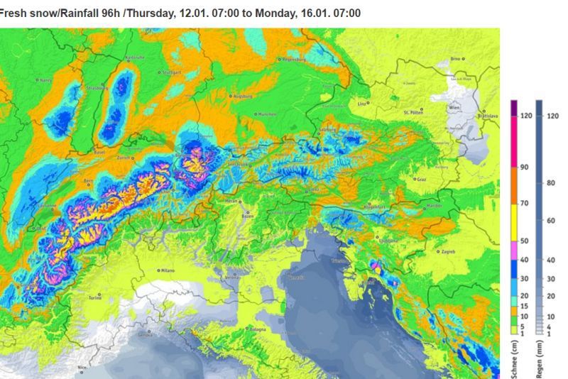 The north-west will benefit most from the predicted snowfall between now and Sunday – Image: bergfex.com
By the “north-western Alps” we mean the northern French Alps roughly north of Alpe d’Huez/Les 2 Alpes, most of the Swiss Alps (away from parts of the far south) and the western Austrian Alps (especially the Vorarlberg) – essentially any resort roughly north of a straight line between Grenoble in the west and St Anton in the east.
Areas that will do very well from the impending storm include L’Espace Killy, the 3 Valleys, the Paradiski, Chamonix, the Grand Massif, Megève, La Clusaz, the Portes du Soleil, Villars, Verbier, the Jungfrau Region, Engelberg, Lech and St Anton. The rain/snow limit may briefly rise to 1400m in some western parts of the Alps this evening but will generally be low, especially from later tonight onwards when snow will fall to pretty much all levels.
Further south and east of the areas mentioned above, snowfall totals will be considerably more modest, with only bits and pieces here and there across the southern Alps.
Looking a bit further ahead, snow showers will continue to very low altitudes across the northern Alps this weekend. For more on snow conditions in the Alps, check out our detailed snow report updated later today.
Updated: 10am Wednesday 11 January 2017 - Plenty more snow in the forecast, heaviest in the north-western Alps
Yesterday it was the turn of the north-western Alps to see some snow, with 5-15cm (very locally 20cm) reported across a wide swathe of the French and Swiss Alps (away from the far south). Resorts that benefited included the 3 Valleys, the Grand Massif, the Portes du Soleil, Chamonix, La Clusaz, Villars, Verbier, the Jungrfau region and Engelberg, to name just a few.
 20cm of new snow above Les Saisies yesterday has made things look much more like winter! – 11 January 2017 – Photo: lessaisies.com
It may not have been a huge amount of snow but it did fall to very low altitudes, even causing some trouble in some of the towns and cities (e.g. Annecy, Martigny).
Today there a few flurries here and there across the eastern Alps but most areas are dry, with plenty of sunshine to start the day in the west. It won’t last, however, as cloud moves back into the north-western Alps this afternoon with the arrival of a weak warm front.
This will bring a little snow back to the northern French and Swiss Alps away from the far south later in the day, perhaps also western Austria tonight. The rain/snow limit will rise to 1000m close to the northern and western foothills but will remain lower in the more internal sheltered valleys. Snowfall totals will be modest - just a few cm here and there.
 New snow continues to improve conditions in the Portes du Soleil, though much more is needed for the lower sections to fully open. This is La Chapelle d’Abondance – 11 January 2017 – Photo: snoweye.com
Later on Thursday and on Friday, more active fronts will bring heavier and more widespread snow to the northern and western Alps. Some southern parts of the Alps will also see some snow but generally in lesser quantities.
The most snow is expected to fall between the northern French Alps and the Austrian Arlberg, including resorts such as Chamonix, Avoriaz, Wengen/Mürren, Engelberg, Lech and St Anton. Between 30cm and 60cm of new snow is expected here by Saturday, locally even more.
 The Dolomites are still mostly reliant on man-made snow. This is Corvara – 11 January 2017 – Photo: dolomitisuperski.com
So snow conditions continue to improve across the northern Alps though more is still needed before most resorts can get close to being anything like fully operational. Currently the best conditions are in Austria (away from the south), but with lots of snow forecast across the northern French and Swiss Alps over the next few days, the entire northern side of the Alps should be in pretty good shape by the weekend.
With some exceptions (e.g. Cervinia, Sestriere) many southern resorts are still heavily reliant on artificial snow. That said, they are doing an excellent job with 1052km of pistes now open in the Dolomiti Superski area (e.g. Val Gardena, Alta Badia, Kronplatz, Cortina), almost entirely on man-made snow.
Updated: 9.30am Tuesday 10 January 2017 - Some fresh snow today, mostly for the north-western Alps
It’s the turn of western Alps to see some snow this morning, though quantities will be relatively modest. We are expecting 10-15cm across the northern French Alps (e.g. Avoriaz, Flaine, 3 Valleys, Val d’Isère) with a maximum of 20cm in one or two favoured spots.
 Snow expected in the Portes du Soleil today. This is Champéry – 10 January 2017 – Photo: telechampery.ch
The western and northern Swiss Alps will also see a little snow, with 10-15cm possible in Wengen and Engelberg, for example. Generally speaking, however, the further south and east you are, the less you will be affected. The southern French and far western Italian Alps could see a dusting but the central and eastern Italian Alps, as well as most of Austria will miss out this time around.
Wednesday will be mixed with a few snow showers across some northern parts of the Alps but also plenty of dry bright weather, especially in the south. Then on Thursday a more potent storm will arrive from the north-west and influence the weather until the weekend, with significant snow expected across a wide part of the northern and especially north-western Alps (e.g. Chamonix, Avoriaz, Verbier, Engelberg and Lech).
 Many southern parts of the Alps are still heavily dependent on artificial snow. This is Passo Tonale – 10 January 2017 – Photo: passotonale.it
In the meantime, snow conditions remain best in Austria (away from the far south) thanks to multiple recent snow storms. Elsewhere in the northern Alps, conditions have improved (to various degrees), and will continue to do so this week. That said, there is no denying the fact that snow depths are still way below par for early January, that most resorts are still not fully open and that off-piste opportunities remain relatively limited.
The southern Alps have also missed out on most of the recent snow and, with some exceptions (e.g. Sestriere, Cervinia), are still heavily dependent on artificial snow.
Updated: 10.40am Monday 9 January 2017 - More snow in the forecast, mostly for the northern Alps
It’s a dry day for most of the Alps today with plenty of sunshine and just a little cloud here and there, thickest in the eastern Austrian Alps where the odd light snow flurry is possible. After a very cold start, it will turn a little milder than of late in the western Alps (freezing levels as high as 1800m in the southern French Alps) but will remain close to or below freezing at all levels in the eastern Austrian Alps.
 Excellent snow conditions in the Tux valley – 9 January 2017 – Photo: foto-webcam.eu
Tomorrow a weak weather front will bring a little snow to the western Alps – especially the northern French and western Swiss Alps (e.g. Portes du Soleil, Bernese Oberland) but probably no more than 5-15cm. A few flurries will persist across some northern parts of the Alps on Wednesday but then all eyes are on what happens towards the end of the week when some more serious snow is expected across the northern half of the Alps from Thursday onwards.
At this stage the heaviest snow from this more powerful storm is likely to fall between the Portes du Soleil (e.g. Avoriaz) and the Arlberg (e.g. Lech), including resorts such as Villars, Mürren and Engelberg, all of which could see 25-50cm (locally more) between Thursday and Saturday.
In the meantime, snow conditions remain best in Austria (away from the far south) thanks to multiple recent snow storms. Elsewhere in the northern Alps, conditions have also improved in recent days to various degrees – quickest in the eastern Swiss Alps, but much more slowly in the northern French Alps where they are still waiting for that killer dump. The southern Alps have also missed out on most of the recent snow and, with some exceptions (e.g. Sestriere, Cervinia), are still heavily dependent on artificial snow.
Updated: 1.50pm Sunday 8 January 2017 - Further fresh snow across the northern Alps
Further snow has been falling across many northern parts of the Alps, including the (far) northern French Alps (e.g. Portes du Soleil) where, contrary to what had been forecast, Avoriaz clocked 12cm last night. Generally speaking, 10-20cm fell quite widely across the northern Swiss and Austrian Alps, with 30cm+ locally in Austria, where it is still snowing in places today. Much of the southern Alps has again missed out.
 Improving conditions in the Portes du Soleil. This is Morgins – 8 January 2017 – Photo: telemorgins.ch
After a mostly fine day on Monday, further snow will reach some northern parts of the Alps on Tuesday and Wednesday, this time favouring the north-west (i.e. the northern French Alps).
Quantities won’t be huge, but a much more potent storm is expected to deliver more serious snowfall totals to the northern and western Alps on Thursday and Friday.
 Fresh snow in Damüls in Austria – 8 January 2017 – Photo: damuels.at
The best snow right now is in Austria (away from the far south), but conditions are generally improving across the northern half of the Alps and will get better still as the week progresses.
Conditions in the southern half the Alps are still split between resorts in the south-west (e.g. Sestriere, Pila, Cervinia), which are still doing well from storms back in December, and most other regions (e.g. the Dolomites) that are still heavily dependent on artificial snow.
Updated: 8.25am Saturday 7 January 2017 - Cold, more snow for some northern and eastern areas tonight
It’s a cold morning, bitterly cold in the eastern Alps where temperatures are as low as -20°C in parts of Austria, even at low altitude (e.g. Salzburg). It will be mostly dry though, at least during daylight hours. The best of the sunshine will be in the southern half of the Alps while cloud will increase later in the day further north.
 A very wintry looking morning in Leogang, Austria – 7 January 2017 – Photo: saalfelden-leogang.com
Some snow will reach the northern Alps tonight, continuing for a while tomorrow. The snow will be heaviest in Austria to the east of Innsbruck (10-30cm) but generally lighter in western Austria and Switzerland (2-20cm), with no more than a dusting across the northern French Alps. The southern Alps will stay mostly dry.
Monday will remain mostly dry, before further snow reaches the Alps on Tuesday. This time it will favour the north-west (i.e. France) albeit still in modest quantities (2-20cm). Watch out for some heavier and more widespread snow later in the week though.
 Dolomite resorts such as Kronplatz are still heavily reliant on artificial snow – 7 January 2017 – Photo: kronplatz.com
Monday will remain mostly dry, before further snow reaches the Alps on Tuesday. This time it will favour the north-west (i.e. France) albeit still in modest quantities (2-20cm). Watch out for some heavier and more widespread snow later in the week though.
In the meantime, the best snow conditions are now in Austria (away from the far south) thanks to significant snowfall during the middle of last week. Eastern Swiss resorts (e.g. Klosters, Laax) are also vastly improved.
With a few exceptions (such as Tignes, Val Cenis and Montgenèvre), many French resorts are still heavily reliant on artificial snow.
Some western Italian resorts aside (e.g. Sestriere, Cervinia), much of the southern Alps are also still heavily dependent on man-made efforts. The Dolomiti Superski area (Val Gardena, Alta Badia, Cortina etc.) now has over 1000km open despite very little natural snow.
Updated: 10am Friday 6 January 2017 - Very wintry, in the north-eastern half of the Alps at least…
There are some clouds and a few light flurries in the eastern Austrian Alps this morning, but for most areas the sun is back. However, it is cold - bitterly cold in the eastern Alps where maximum temperatures will struggle to get above -5°C even in the cities (e.g. Innsbruck). It won’t get above -20°C on the glaciers and, coupled with a strong north-easterly wind, the wind-chill will make it closer to -40°C!
 Lots of new snow to low levels in Bavaria. This is Hochries – 6 January 2017 – Photo: hochriesbahn.de
Extreme cold aside, snow conditions are fabulous in the north-eastern half of the Alps thanks to all this new snow. Generally speaking we have seen 30-50cm of new snow fall in Austria (away from the far south), parts of Bavaria and the eastern half of the Swiss Alps, including resorts such as Flims, Lech, St Anton, Saalbach, Kaprun, Kitzbühel and Hintertux, to name just a few. Very locally there has been up to 70cm.
Note, however, that while off-piste opportunities are increasing, the situation remains complicated – partly due to the winds, partly due to the lack of or thin base that the snow fell on to. Always take an experienced guide!
 Winter wonderland in the Austrian Bregenzerwald. This is Damüls – 6 January 2017 – Photo: damuels.at
Elsewhere in the Alps there has been a little snow here and there – 5-15cm in the western Swiss and northern French Alps (e.g. Verbier, Avoriaz, Les Arcs) for example, some even getting through to the southern Alps (e.g. Livigno, Cervinia).
However, as a rule, the further south-west you are, the less likely you are to have seen any meaningful snow from this storm - with some areas (e.g. the Milky Way) having missed out completely.
 Beautiful winter scene in Zell-am-See – 6 January 2017 – Photo: zellamsee-kaprun.com
For more details on snow conditions in general please see our latest snow report.
Looking a bit further ahead, there will be some more snow in places over the weekend, chiefly in the east (i.e. Austria) with the focus perhaps more on the north-western Alps by Tuesday.
Check out our more detailed weather forecast for the Alps which will be updated later today…
Updated: 10am Thursday 5 January 2017 - Serious snow for north-eastern Alps!
The forecast has gone more or less to plan, with fresh snow for many (but not all) parts of the Alps this morning. The heaviest snow has been in the north-east (Austria and the eastern Swiss Alps) where some areas have seen as much as 60cm of new snow. By contrast, the north-western Alps (i.e. the northern French Alps) have only seen a few centimetres of snow, and some southern parts of the Alps have missed out altogether.
 Winter in Lech at last! – 5 January 2017 – Photo: lech-zuers.com
Going into a bit more detail, the areas with the most fresh snow are the eastern Swiss Alps (e.g. Laax) and Austria (away from the far south), including the Vorarlberg (e.g. Lech), the Tirol (e.g. St Anton, Ischgl, Kitzbühel), the Salzburgland (e.g. Kaprun), Styria (e.g. Schladming) and Upper Austria (e.g. Bad Ischl). These areas have already seen 25-50cm of new snow, locally 60cm according to the Tirol Avalanche service, with more to come today.
As a rule, the further west and south you are the less fresh snow there has been. In the western Swiss Alps, for example, Mürren has seen about 15cm while Verbier has seen about 10cm. The northern French Alps have also only seen a maximum of 10-15cm - with 10cm in Avoriaz, Flaine, Les Arcs and Val Thorens, for example.
As expected, most southern parts of the Alps have seen little or no snow from this storm but there have been one or two exceptions. For example, in the north-west, Cervinia saw up to 30cm on its highest peaks and, in the central Italian Alps, Livigno also saw a moderate fall of snow. However, in the south-west, Sestriere missed out completely this time round.
 Heavy snow still in progress in Studen in the Swiss canton of Schwyz – 5 January 2017 – Photo: studen-sz.ch
It will continue snowing across some northern and especially north-eastern parts of the Alps for much of today with an additional 20cm or more in places. Further south and west, any showers will be lighter with sunshine prevailing in the southern French and south-western Italian Alps. Note it will also be bitterly cold, well below freezing at all levels in the eastern Alps, and a couple of degrees above at best in some western areas. The cold will be compounded by the strong wind, especially at altitude.
Friday will continue to be bitterly cold, especially in the eastern Alps where further snow flurries are possible at times (though generally lighter than recently). The western Alps will see the best of any sunshine. It will turn a fraction milder (though will still be cold) over the weekend, with further snow showers possible in places, again chiefly in the east.
In theory, snow conditions are now much improved across large parts of Austria and Switzerland (especially eastern Switzerland). However, it should be noted that avalanche danger is now high in these areas, exacerbated by the strong winds that have deposited the snow in a highly irregular fashion.
In many cases, the snow has also fallen either on a thin or non-existent base, which not only is bad for cohesion but also means that there will be “hazards” under the surface off-piste. It is also still snowing, still windy and bitterly cold today, so our advice is to stay on the beaten track until the weather improves (hopefully tomorrow) and only venture off-piste if you know exactly what you are doing or have an experienced guide.
Further west (e.g. Verbier and the big French resorts) the new snow is largely aesthetic and won’t make a great deal of difference to the off-piste situation.
Updated: 9.55am Wednesday 4 January 2017 - Heavy snow for some…
At last, a proper winter storm from the north! It won’t deliver for everyone, but the landscape will be transformed over the next 24 hours for a good part of Austria and Switzerland, at least. Further west the big French resorts will miss the heaviest of snow, however, as will the southern Alps - where some places will stay completely dry.
 Snowing in the Gastein valley in the eastern Austrian Alps this morning – 4 January 2017 - Photo: gastein.at
The northern French Alps (meaning roughly anywhere north of Grenoble - including the 3 Valleys, Les Arcs, La Plagne, Val d’Isère, Tignes, Megève, Chamonix, Flaine, La Clusaz and the resorts of the Portes du Soleil) will only see modest amounts of snow over the next 24 hours. Maximum amounts forecast are around 5-12cm in the likes of Avoriaz and Flaine in the Haute-Savoie, but perhaps only 2-5cm in the big Tarentaise resorts (such as Courchevel and Val d’Isère) and next to nothing by the time you get as far south as the Maurienne valley (e.g. Val Cenis, Valloire).
Moving further east into western Switzerland and the predicted snowfall totals increase a little, with 5-15cm likely for Zermatt, Verbier and Villars, but as much as 15-30cm for the Bernese Oberland (e.g. Wengen, Murren).
Moving further east still we are looking at about 25-40cm for Engelberg, Laax and Davos/Klosters, with perhaps 50cm+ or more very locally in some resorts in the triangle between Lucerne, Chur and Zurich. Some snow will also get into the south-east of Switzerland but in lesser quantities, with 10-20cm expected in St Moritz, for example.
 New snow and improving conditions in the Austrian Vorarlberg today. This is Damüls – Photo: damuels.at
Moving into western Austria and the Vorarlberg, we could see some of the highest snowfall totals from this storm, with 40-60cm quite possible for the likes of Lech/Zürs, Warth-Schröcken and the Montafon region. Indeed, away from the far south (i.e. Carinthia and parts of the Osttirol) most Austrian resorts away will see significant snow, with 20-50cm (locally a bit more) expected in the likes of St Anton, Ischgl, Saalbach, Kitzbühel and the Ski Welt region.
With one or two exceptions, the southern Alps won’t do as well from this storm, with many resorts missing out altogether. Livigno is one such exception, where 10-20cm of snow is possible. Others are Cervinia and Courmayeur, where 10-15cm is also possible at altitude. Further south, however, the likes of Sauze d’Oulx and Sestriere are expected to stay completely dry.
 This time it’s the south-western Alps’ turn to miss out. This is Sestriere – Photo: vialattea.it
The snow will continue for a while (in the above-mentioned areas) on Thursday before gradually dying out. The week will then end mostly dry but bitterly cold, especially in the eastern Alps (i.e Austria), compounded by the wind that will continue to blow strongly in exposed areas.
In theory, snow conditions will be much improved across many northern and eastern parts of the Alps, but note that the off-piste is likely to be very hazardous for several reasons:
- the snow will be severely windblown, at least at altitude;
- in many places the snow will be falling onto a thin and icy base (a recipe for increased avalanche risk); and
- lower down, the snow will often be falling onto no base (which means potential hazards under the surface).
Whatever the situation, a good guide is always recommended!
Looking a bit further ahead and there is more snow in the forecast at times next week, and even significant snow, particularly towards the middle of the month. Exactly where the heaviest snow will fall is still up for grabs, but at this stage it looks like favouring the north again. Watch this space…
Updated: 10.40am Tuesday 3 January 2017 - A little new snow in the northern Alps and plenty more in the forecast
As expected, some northern parts of the Alps saw a little snow last night. In the French Alps it was no more than the faintest of dustings close to the northern foothills, but in the Swiss and Austrian Alps it was more noticeable, with as much as 10cm in Engelberg, for example, as well as close to Salzburg. Most of the Alps did miss out though.
 Looking a bit more wintry in Schröcken this morning, with lots more snow to come tomorrow – 3 January 2017 – Photo: warth-schroecken.com
Today will be another mostly dry if rather chilly day with good sunny spells above any residual low cloud. Tomorrow another cold front will reach the northern Alps, this one more active than the last, delivering significant quantities of snow to low altitude across much of Austria (away from the far south) as well as the northern and eastern Swiss Alps.
Resorts that will do well include Engelberg, Laax, Klosters, Lech, St Anton, Ischgl, Saalbach, Kitzbühel and the Ski Welt, to name just a few. These areas will see between 30cm and 50cm of new snow between Wednesday and Thursday, very locally 70cm. The far north-western Alps - including the Swiss Alps (e.g. Villars) as well as the northern French Alps (e.g. Avoriaz) - will generally see less snow (5-20cm), and many southern parts of the Alps will miss out altogether.
 Many resorts are still heavily reliant on artificial snow, including this is Alpe d’Huez – 3 January 2017 – Photo: alpedhuez.net
In the meantime, snow cover remains way below par for early January across most parts of the Alps with many resorts still heavily dependent on artificial snow. The worst affected areas are in the north-west where it hasn’t snowed properly for 50 days (e.g. Portes du Soleil, Grand Massif, La Clusaz) making it the driest early season here on record.
The deepest snow cover in the Alps remains at altitude in the south-western Alps (e.g. Cervinia, Sestriere, Montgenèvre, Val Cenis).
Updated: 11.35am Monday 2 January 2017 - Significant snow for the northern Alps on Wednesday and Thursday
A band of rain, sleet and snow is currently sitting across northern France and central Germany and moving slowly southwards towards the Alps. It is being brought about by a weak cold front that will deliver a dusting of snow to some northern, and especially north-eastern, parts of the Alps this evening and tonight.
 Predicted snowfall totals over the 24 hour period starting at 7am Wednesday 4 January 2017 – Image: bergfex.com
Before this front arrives, many parts of the Alps will enjoy some sunshine this morning – indeed it will stay sunny in the southern half of the Alps all day. However, high clouds are already in evidence close to the northern edge of the Alps and these will thicken further this afternoon as the front moves in. Expect the first precipitation close to the northern foothills by late afternoon, spreading to other parts of the northern Alps overnight.
Any precipitation will be very light and patchy in nature, virtually non-existent in the northern French Alps, but a little more moderate at times in some parts of Switzerland and Austria where 5-10cm is possible in a few favoured locations. The rain/snow limit will be around 600-900m or even lower later in the night.
After another mostly fine day on Tuesday, a more active set of weather fronts will affect the northern Alps on Wednesday and Thursday. This will bring more significant snow (to very low levels) across the northern half of the Alps, with 50cm+ possible in places, especially in the central/northern Swiss Alps and in Austria (away from the south). The northern French Alps will see the least snow and most of the southern Alps will miss out altogether.
 Desperately short of snow in Lech, but it’s all about to change – 2 January 2017 - Photo: schmelzhof.at
Looking even further ahead, the weather pattern for the Alps looks very encouraging with a good chance of further (increasingly widespread) snowfalls next week and beyond. Stay tuned!
In the meantime, snow conditions in the Alps (with one or two exceptions) remain very poor for early January. The main exception to this is still in the south-western Alps where areas such as the Monte Rosa region, Cervina, Pila, Sestriere, Prato Nevoso, Isola 2000 and Montgenèvre are still offering very favourable skiing conditions, at least above 1800-2000m. Val d’Isère and Tignes are also in excellent condition above 2200m, but the vast majority of resorts in the Alps are heavily or sometimes completely reliant on artificial snow.
This doesn’t mean that there isn’t still some perfectly good piste skiing on offer, but the New Year crowds mean the pressure has intensified, especially in areas (mostly the north-western Alps) where only a small proportion of the overall ski area is open.
Updated: 12pm Sunday 1 January 2017 - Some snow this week, heaviest in the northern Swiss and Austrian Alps
The first day of 2017 will be a sunny one for the Alps with freezing levels close to 2000m in many places. Tomorrow the weather will start to change as a weak cold front moves down from the north.
 One more day of wall to wall sunshine across the Alps. This is Zell-am-See – 1 January 2017 – Photo: zellamsee-kaprun.com
This cold front will bring some snow to the northern half of the Alps later on Monday with a rain/snow limit starting around 1000-1300m but falling to low levels on Monday night. Snowfall totals will modest, perhaps no more than a dusting in the northern French Alps, and 2-10cm further east in the Swiss and Austrian Alps. Except for a few flurries here and there, the southern Alps will stay mostly dry.
After a mostly fine day on Tuesday, further snow will affect the northern Alps on Wednesday and Thursday. Snowfall totals will again be very modest in the northern French Alps, but could be a bit more significant this time in parts of Switzerland and Austria, with 30cm+ in a few favoured spots. However, the southern Alps will again miss out.
For more details on snow conditions in the Alps check out our latest snow report.