

Latest snow forecast
Updated: 9am Sunday 15 January 2023
The weather in the Alps is turning more wintry, with much-needed snow due in nearly all areas in varying quantities over the next few days. We will not see the extreme snowfall totals that were on the cards a few days ago, however most places (perhaps the exception of the extreme south-west - e.g. Isola 2000) will see a decent amount. What’s more, it is set to turn cold and stay cold for some time, meaning that this snow will not only stay but can also be topped up by snowmaking at all altitudes.
Although the broadscale picture is now clear for this week, the finer detail is still complicated and estimating snowfall amounts remains tricky. There may be some surprises, especially in the Dolomites, which will often be on the edge of some very moist and unstable air being thrown up from the Mediterranean.
Broadly speaking, it is likely to be the north-west (e.g Portes du Soleil, Grand Massif), the far south of Austria (e.g. Nassfeld, Bad Kleinkirchheim) and perhaps also parts of the Dolomites that will see most of the snow, with 40-70cm likely by the end of the week. Elsewhere, 20-40cm seems a more reasonable estimate, with only the far southern French and south-western Italian Alps (e.g. Isola 2000, Prato Nevoso) likely to miss most of the action.
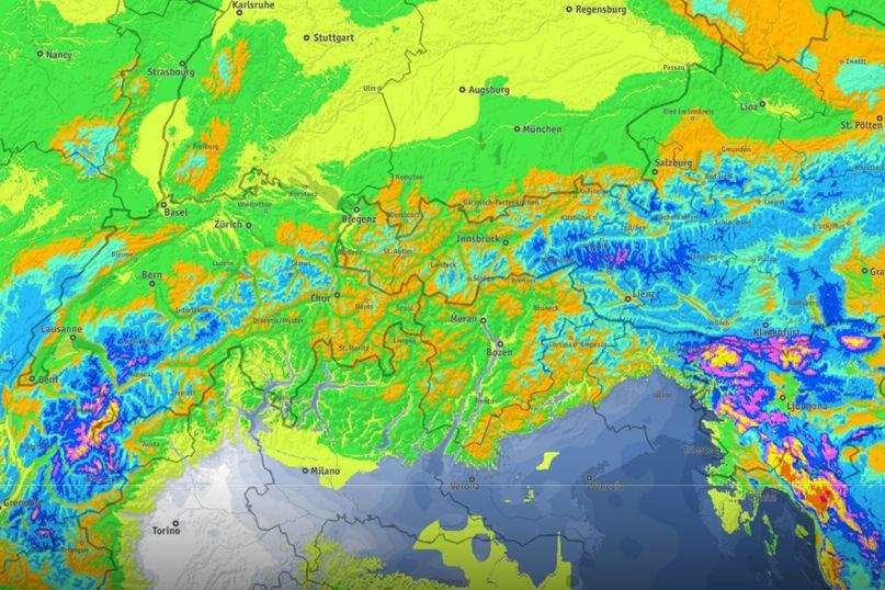 Over the next five days, the greatest quantities of snow (yellow and pink) are set to fall in the northern French Alps and Austria’s Carinthia region – Image: bergfex.com, 15 January 2023
Detailed weather & snow forecast:
Austria
Sunday will start dry but often rather cloudy in parts of the Austrian Alps, with thickening cloud bringing rain/snow to the far west (e.g. Arlberg) this morning, spreading across the northern half of the Austrian Alps later in the day.
The far south (e.g. Nassfeld) will stay dry for most of the day but may catch a heavier pulse of snow tonight. The rain/snow limit will start at around 1200-1400m but fall very quickly to 600m or so this evening. The most snow will fall in the far west, with 10-15cm possible at altitude in the Arlberg, and closer to 5cm in the likes of Saalbach and the Ski Welt. The far south (e.g. Bad Kleinkirchheim, Nassfeld) could see as much as 30cm tonight.
Monday will be mostly cloudy with scattered snow flurries, heaviest in the far south (e.g. Bad Kleinkirchheim, Nassfeld) and lighter elsewhere, though perhaps heavier for a time in the far west (Arlberg) later. The rain/snow limit will be between 600m and 900m. Snowfall accumulations are expected to broadly be in the range of 2-10cm, with 15cm in some parts of the far south.
Tuesday will see further flurries in many areas although they are likely to be lighter and more scattered than on Monday, with some brighter spells at times.
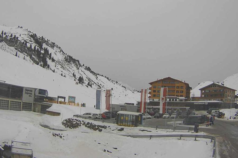 Cloudy today in the Austrian Vorarlberg with snow expected later. This is Warth-am-Arlberg – 15 January 2023 – Photo: warth-schroecken.at
France
Sunday will be mostly cloudy in the French Alps, with rain/snow reaching the north-western foothills early in the day and spreading to most other areas later, though the far south (e.g. Isola 200) will stay dry and bright. The rain/snow limit will start at 1500-1700m but quickly fall to reach 600m this evening. The northern French Alps will see the most snow, with 10-20cm likely tonight above 1500m in Avoriaz, Flaine and Les Arcs. Further south, there will only be 5-10cm in Serre Chevalier and next to nothing in Risoul.
Monday will be mostly cloudy with snow showers or longer spells of snow, especially later in the day, this time affecting both the northern and southern Alps more evenly - though the far south (Isola 2000) will probably still miss most of the action. Elsewhere we can typically expect 10-20cm with a rain/snow limit of between 400 and 700m.
Tuesday will be similar with further flurries and a few more centimetres to very low levels across much of the French Alps, but again drier in the far south.
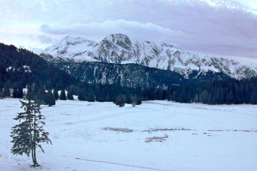 Cloud is thickening in the French Isère this morning, with some rain/snow expected later. This is Chamrousse near Grenoble – 15 January 2023 – Photo: chamrousse.com
Italy
Sunday will see a lot of cloud across the Italian Alps though most places are starting dry. A band of mostly light rain/snow will move east during the day, though the far south-west (e.g. Limone) will stay dry. Most places can expect between 2-8 cm of snow by tonight, but with 10cm or more possible in the north-west (e.g. Courmayeur, La Thuile) and the Dolomites (e.g. Cortina), though the latter won’t see the heaviest snow arrive until tonight. The rain/snow limit will start around 1200-1500m but will quickly fall to under 1000m later in the day.
Monday will be cold and mostly cloudy, with further flurries to low altitudes in many areas, heaviest in the Dolomites and, later in the day, in the far north-west. Both these regions could see another 10-15cm, while the central Italian Alps (e.g. Livigno) and the far south-west (e.g. Prato Nevoso) might only see a dusting at best.
Tuesday will see further flurries (to low levels) in many areas, though they will generally be lighter and more scattered than on Monday.
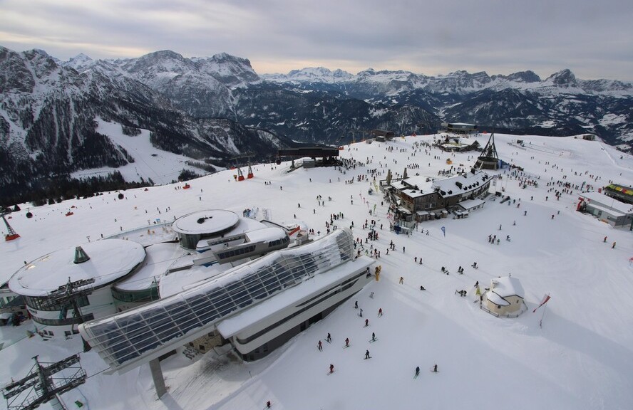 Mostly dry today in Kronplatz but snow is expected tonight – 15 January 2023 – Photo: kronplatz.com
Switzerland
Sunday will see rain/snow spreading across most of the Swiss Alps from the north-west, heaviest in the far west (e.g. Portes du Soleil) in the afternoon, and lighter and patchier in the far south and south-east. The rain/snow limit will start at around 1500m but will quickly fall to 600m or so this evening. Snowfall totals by tonight are generally expected to be in the region of 10-15cm (e.g Verbier, Crans Montana, Murren, St Moritz), with 15-20cm above 1500m in the west (e.g. Morgins), but only a dusting in Ticino close to the Italian border (e.g. Bosco Gurin).
Tuesday will be cold and mostly cloudy with snow showers, heaviest and most frequent in the west (e.g. Portes du Soleil) where another 15-20cm is possible. Most other areas will generally see around 5-15cm, though there will be very little if any snow in the far south (e.g. Bosco Gurin) and south-east (e.g. St Moritz). The rain/snow level will be between 400m and 600m.
Tuesday will be cold with some mostly light snow flurries in many areas, but again heavier and more persistent in the west where another 10-20cm is possible in places. The rain/snow limit will be very low.
Outlook:
It will remain cold on Wednesday and Thursday with further flurries likely in places, mostly in the northern Alps but always with the chance of some heavier snow in the extreme south-east (Dolomites).
By Friday it is likely to be the eastern Austrian Alps (e.g. Obertauern) that see the heaviest of the snow.
Our next detailed weather & snow forecast will be on
Saturday 21 January 2023
If you enjoy reading our updates - please feel free to support us: