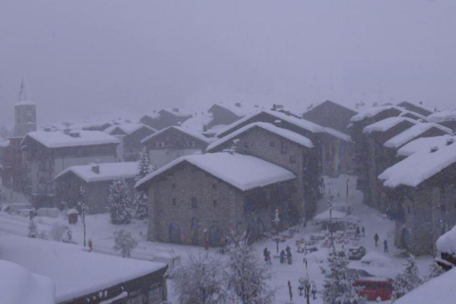
A brief calm has descended upon the Alps today, although there is still plenty of cloud around, especially at lower altitudes. This afternoon the cloud will thicken up more generally in the west, heralding the arrival of the next big storm!


Got a burning question about weather or snow conditions in the Alps?
Contact us and we'll do our best to answer it...
Updated: 12.30pm Sunday 15 February 2026 – Brief calm before the next storm rolls in from the north-west!
A brief calm has descended upon the Alps today, although there is still plenty of cloud around, especially at lower altitudes. This afternoon the cloud will thicken up more generally in the west, heralding the arrival of the next big storm!
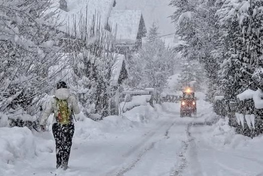
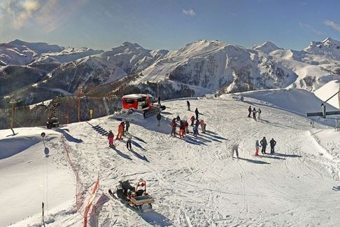
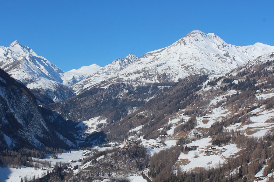
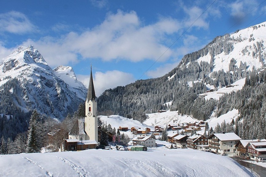 Weather window in Schröcken in the Austrian Vorarlberg where a lot of snow is expected on Monday and Tuesday – Photo: foto-webcam.eu, 15 February 2026
This time, a wide swathe of the northern Alps will see significant snowfalls, all the way from the Écrins (just south of Grenoble) through to the Arlberg, including most of Switzerland (away from the far south). This region will see 30–70cm of snow above 1500m between and , with the heaviest falls in the northern French Alps (e.g Tignes, Val Thorens) and the Arlberg (e.g. St Anton, Lech).
Some snow will also get through to the eastern Austrian Alps (e.g. Obertauern) and across the border to some southern resorts like Livigno but generally in more modest quantities. Far southern resorts, such as Isola 2000 and most of the Dolomites, will see very little, if any, snow.
The rain/snow limit in the western Alps may start low but will quickly rise to 1200–1600m before falling back towards 1000–1200m again . The rain/snow limit will continue to descend steadily during to reach 600–1000m later in the day.
Updated: 10.30am Saturday 14 February 2026 – Another big dump, this time in the far south-west...
While all attention centred on the bigger ski resorts, another storm approached the south-western Alps yesterday, dumping up to 50 cm of fresh snow in some southern parts of the Piemonte (e.g. Prato Nevoso) overnight.
 Another 50cm of snow last night for Prato Nevoso in the southern Piemonte – 14 February 2026 – Photo: pratonevoso.com
Today the weather in the Alps is a bit complicated, with some further snow in places. Any snow showers in the central and western Italian Alps will gradually die out, but flurries will become more frequent across the northern Alps later today and overnight, especially in Switzerland and Austria (e.g. Engelberg, Lech, Kaprun) where 10-15cm is possible with a rain/snow limit descending to very low levels.
Then after a relative reprieve tomorrow, the next storm – another big one – will hit the Alps on Sunday night, impacting the Alps on Monday and into Tuesday.
The western Alps will again see the most snow, with 40-60cm likely at altitude in the north-west (e.g. Tarentaise). Further east, snowfalls will be more modest but still significant in places. Another big storm is then forecast for later in the week! Stay tuned…
Also deserving a special mention are the Pyrenees, where it is very stormy today with many roads closed, including (at the time of writing) the main route into Andorra on the French side. Snow levels are incredible across much of the Pyrenees but in the short term the wild weather is causing plenty of issues. Be warned if travelling out there this weekend!
Updated: 10am Friday 13 February 2026 – The big storm is over, but avalanche danger in the western Alps remains sky high...
The big “western storm” is over, the sun is out, and the slopes look unbelievably enticing, however, the avalanche danger remains critical.
 Sun and fresh snow this morning in Châtel – 13 February 2026 – Photo: Guillaume Rodiere
Indeed, with 1m to 1.5 m of new snow in the last few days across many French, and some far western Swiss and far north-western Italian ski resorts, it will take a while for authorities to make many pisted areas safe.
As for any off-piste, as far as we are concerned, this should be avoided at all costs in these snowy areas today. It pays to remember that most avalanche incidents are within sight of the pistes.
More snow is on the way to the Alps over the next few days, arriving first in the south-western Alps (e.g. Isola 2000, Prato Nevoso) which will see falls of 20-40cm tonight, then across the northern Alps on Saturday (e.g. Avoriaz, Mürren, Lech, Kaprun) but in much more modest quantities (typically 3-10cm).
Watch out on Sunday night and Monday though, as a much larger storm will see very significant snowfall return to the western Alps, also pushing a bit further east this time around.
Updated: 9am Thursday 12 February 2026 – Very snowy in the western Alps, with maximum avalanche danger warning in places...
It’s another very snowy day across the western Alps, particularly in France where the avalanche danger warning is a rare 5/5 maximum in parts of the Savoie, notably between the Mont Blanc and Tarentaise areas.
 Very heavy snow this morning in Tignes – 12 February 2026 – Photo: tignes.net
This unusual situation has necessitated some ski resorts in the area to close most, and in some cases (e.g. La Plagne) all, of their ski areas until they can be made safe. Needless to say, do not venture off piste, and follow all official advice in terms of driving and walking around resort.
alone may see another 40–50cm of snow fall above 1800m in parts of the northern French Alps (e.g. Tignes, La Rosière, Flaine, Avoriaz). When added to the considerable quantities of snow that have already fallen since , storm totals above 1800m will be over 1m in most northern French resorts by the end of (if they are not already), with 1.5m in a few areas.
The far west of Switzerland (e.g. Glacier 3000, Portes du Soleil) and the far north-western Italian Alps (e.g. Courmayeur, La Thuile) will also see storm totals of over 1m at altitude this week, with closer to 1.5m in the Mont Blanc region.
, the rain/snow limit in the western Alps is approximately 1200–1400m but gradually descending.
Elsewhere in the Alps, any snowfall will be more sporadic the further east and south-east you are, as it has been much of this week, with the really eye-catching snowfall totals confined to the far west.
, the weather will be much calmer in most regions, although a new storm will clip the south-west (e.g. Isola 2000, Prato Nevoso) later in the day, delivering a few centimetres of snow here and there.
On , further snow will affect some parts of the Alps, mostly across the north and in relatively modest quantities. However, another major storm is then set to reach the western Alps on . Stay tuned for updates…
Updated: 11am Wednesday 11 February 2026 – Big “western” storm cycle underway in the Alps...
It has been snowing heavily in the western Alps this morning and to lower levels than forecast!
 Heavy snow today in Val d’Isère today – 11 February 2026 – Photo: valdisere.com
In the northern French Alps, for example, we were expecting a rain/snow limit close to 1500m this morning, perhaps a little lower under the heavier precipitation. Instead, heavy snow has fallen to between 900m and 1200m which is great news for the lower resorts (e.g. Portes du Soleil) where the damage from any rain (most of it having fallen yesterday evening) has not been too consequential.
That said, there remain considerable variations in the rain/snow level today, with rain still possible to 1400m or so in places.
After a slightly calmer period of weather this afternoon, a new wave of precipitation will reach the western Alps tonight and last most of tomorrow. The rain/snow limit will generally be between 1000m and 1300m, but possibly a bit lower under the heavier precipitation tomorrow.
Throughout this period, any precipitation will (on the whole) be lighter and patchier the further east and south-east you are. Some showers will get through to the western Austrian Alps today and especially later tomorrow, but the south-eastern Alps (e.g Dolomites) will remain mostly dry with some sunny spells.
So, this week it is the western Alps that will be seeing the really big snowfall totals, especially in the French Alps, the far north-western Italian Alps (e.g. Courmayeur, La Thuile) and the western Swiss Alps (e.g. Verbier, Glacier 3000). These regions will all see storm totals of over 1m above 200m (between Tuesday and Friday) with 1.5m possible in places, especially in the higher resorts of the northern French Alps (e.g. at altitude in La Rosière, Flaine, Chamonix, Avoriaz).
Needless to say, the risk of avalanche is becoming critical in many western Alpine regions and could even hit the highest alert of 5/5 in places on Thursday.
Flooding is also an issue in many of the lower valleys, with a number of roads either blocked or cut off. Stay tuned for updates!
Updated: 12pm Tuesday 10 February 2026 – Big “western” storm cycle underway in the Alps...
The big storm cycle that we have been anticipating for some time is well underway, with bands of precipitation moving from west to east across the Alps, though tending to weaken in the process.
 Heavy snowfalls already underway this morning in Courmayeur - Photo: Argiland via facebook.com/montagnaneveski.info, 10 February 2026
Already today we have seen snow falling across many western parts of the Alps. After slight reprieve, a new more intense band of precipitation will move into the western Alps this evening, bringing further precipitation, heavy at times, lasting on and off until Friday at least.
Throughout this period, it will always be the western Alps that sees the most precipitation. The rain/snow limit will be all over the place, rising to between 1500m and 2000m for a time this evening and overnight before dropping a little to between 1200m and 1700m tomorrow, then towards 1000m or so during Thursday.
Between Tuesday morning and Friday morning we are expecting over 1m of fresh snow above 2000m across parts of the French Alps (e.g. Tignes, Val Thorens, La Rosière, Flaine, Avoriaz). The far north-west of Italy (e.g. Courmayeur, La Thuile) and the far west of Switzerland (e.g. Glacier 3000, Portes du Soleil, Verbier) could also see similar accumulations. Note that the risk of avalanche will become sky high and there will also be a risk of flooding lower down.
On the whole, the further east and especially south-east you are this week, the less intense any precipitation will be, with some parts of the Dolomites (for example) only seeing a few centimetres at best.
Updated: 11am Monday 9 February 2026 – The calm before the storm...
Following a relatively quiet weekend of weather in the Alps, with just a little top-up of snow in the far south-west (e.g. southern Piemonte) on Sunday, it remains largely dry today, but not for long.
 Sunny skies this morning in Val d’Isère but it will turn much more unsettled from tomorrow – Photo: valdisere.com, 9 February 2026
Starting , a series of Atlantic storms will move in from the west, continuing for the rest of the week and delivering copious amounts of precipitation to many western Alpine regions, especially France. With plenty of milder air in the mix, especially mid-week, there will also be some rain at lower altitudes before snowfall returns to lower levels later in the week.
Between and , we can expect a metre or so of snow above 2000m in some of the higher French ski resorts, including those of the Tarentaise (e.g. Tignes, Val Thorens). Lower down, though, rain is likely to fall as high as 1700–2000m in places on .
Watch out for a big increase in the risk of avalanche as the week goes on, together with the possibility of localised flooding in some lower areas, especially near the western foothills of the Alps.
Separately, the Pyrenees will be in a similar situation this week, but with a higher rain/snow limit (possibly as high as 2600m) mid-week and with an even higher risk of avalanche and flooding.
Updated: 10.30am Saturday 7 February 2026 – Quiet weekend of weather for most of the Alps...
The weather in the Alps will be fairly quiet this weekend, with variable cloud cover but some good sunny spells for most. Late on Sunday, a new storm will approach the south-western Alps, bringing a few centimetres of snow to the far southern French Alps (e.g. Isola 2000) and south-western Italian Alps (e.g Prato Nevoso) overnight.
 Beautiful morning in Lech – 7 February 2026 – Photo: lech-zuers.at
Next week then looks potentially very interesting, with a big storm cycle set to start on Tuesday which will last the rest of the week.
This new stormy phase will be most keenly felt in the western Alps where some serious quantities of snow are likely to fall in the run-up to half term. However, with some milder air in the mix, especially mid-week, there may also be some rain lower down for a time.
Later in the week, the snow level should drop much lower again, with some more northern and eastern areas (e.g. Austria) possibly coming into play. However, for now it is the western Alps that are likely to see the most snow. Watch this space!
Updated: 11am Friday 6 February 2026 – Near perfect snow conditions in the far south-western Alps!
After another storm last night, the far south-western Alps have woken up to sunny skies and near perfect snow conditions.
 Dreamy snow conditions in the far southern French Alps this morning. This is Auron – 6 February 2026 – Photo: auron.com
If you are lucky enough to be in the far southern French Alps (e.g. Isola 2000, Auron) or the southern Piemonte (e.g. Prato Nevoso, Limone Piemonte), it doesn’t get much better than this, though extreme caution is advised off-piste.
Further north in the western Alps (e.g. 3 Valleys, Portes du Soleil, La Thuile, Verbier, Jungfrau region) it is cloudier with showers or flurries, but with a rain/snow limit that will rise towards 1400m or so. A few showers or flurries will make it into the western Austrian Alps but, on the whole, the eastern Alps will remain dry with variable cloud.
For more on snow conditions in the Alps check out our latest detailed snow report published yesterday.
Updated: 11am Thursday 5 February 2026 – Mostly fine in the Alps today, but more snow is coming to some western/south-western regions tonight...
It’s a largely fine day across much of the Alps today, though there is still quite a lot of cloud in the east. Cloud is also thickening again in the west ahead of the next storm, which will bring some snow (1000-1500m) to the western and south-western Alps tonight and tomorrow, heaviest in the southern French Alps and southern Italian Piemonte where another 30cm or more is possible.
 Sunny skies this morning in Morzine, although high cloud is already visible in the west, ahead of the next storm that is set to bring a few centimetres of snow tonight – 5 February 2026 – Photo: morzine-avoriaz.com
Weather fronts from this storm will attempt to move further east later tonight and on Friday but will weaken in the process, meaning that very little precipitation will get through to the central and eastern Alps.
Looking a bit further ahead, the weather in the Alps looks relatively quiet this weekend although more snow may clip the south-western Alps on Sunday. Then next week, after a relatively uneventful start, new Atlantic storms will push in from the west with the prospect of some heavy snow in some areas from mid week onwards, especially in the western Alps.
As for snow conditions in the Alps, check out our detailed snow report, out later today…
Updated: 2pm Wednesday 4 February 2026 – Further snowfalls for some southern parts of the Alps...
It’s a very mixed bag of weather across the Alps today, with snow for some southern areas, heaviest later in the day in the Dolomites and Carinthia. Further north and west it is generally drier but not necessarily sunny, with a lot of high cloud around. There is also a gusty Foehn wind in places.
 More snow in the Dolomites today. This is Alta Badia – 4 February 2026 – Photo: altabadia.org
The snow in the south-eastern Alps will continue to fall overnight, with accumulations of 20-30cm likely across the Dolomites and Carinthia by tomorrow morning, with a rain/snow limit around 1000-1300m.
After a mostly dry day on Thursday, the next storm will reach the western Alps on Thursday night, this time favouring the southern French Alps and some western Italian areas.
As to snow conditions in the Alps, the recent snowfalls have vastly improved conditions in the south, and especially in the south-east (Dolomites), after what had been a very slow start to their season. The south-western Alps (e.g. Piemonte), however, have already been having a good season, pretty much from the off.
The whole of the French Alps is also in pretty good shape, however, most Swiss and Austrian ski areas (Carinthia aside) remain considerably below par in terms of snow depths. Though, even here, there is still lots of good piste skiing on offer.
The weather in the Alps will remain unsettled until February half term at least, with further snow likely in many regions, possibly increasingly favouring the north-west later next week.
Updated: 10.30am Tuesday 3 February 2026 – Fresh snow for the southern Alps...
As expected, a new storm reached the south-western Alps last night delivering around 15-40cm of new snow across the southern French Alps (e.g. Risoul, Isola 2000) and some western Italian ski resorts, especially in the southern Piemonte (e.g. Prato Nevoso).
 Recent snowfalls have greatly improved snow conditions in Cortina ahead of the winter Olympics, which get underway here this week – Photo: cortina.dolomiti.org, 3 February 2026
The snow has now moved east, with this morning’s snowfalls mostly in the far south-eastern Alps (e.g. Dolomites, Carinthia), although quantities are generally quite modest.
, further snow is expected in the Dolomites. Falls will be quite heavy later in the day, with up to 30cm of fresh snow possible in Cortina .
Over the next couple of days there will be very little (if any) snow across the northern Alps, due to its “protection” by the Foehn.
As for snow conditions, they are generally best in France, Italy and the far south-eastern Austrian Alps (Carinthia). However, it is only the resorts of the French Alps and the southern Piemonte in Italy that have close to or, in some cases, above average snow depths for the time of year.
Updated: 10am Monday 2 February 2026 – New storm approaching the south-western Alps...
It’s a beautiful day across much of the Alps, especially in the north and east. However, a new storm is approaching the south-west, bringing snow later today and tonight to many southern French ski resorts (e.g. Risoul, Isola 2000) and some western Italian ski resorts (e.g Prato Nevoso, Setriere, Alagna) too.
 Mostly sunny today in the Austrian Alps. This is Heiligenblut, with Austria’s highest mountain, the Grossglockner in the background – 2 February 2026 – Photo: foto-webcam.eu
This storm will not be as potent as forecast a few days back, typically delivering 10-30cm of snow to these regions, with perhaps a bit more in the southern Piemonte.
Other southern Alpine resorts (e.g. Livigno, Dolomites) will also see a bit of snow later tonight or tomorrow morning, with a more significant fall possible in the Dolomites later on Wednesday.
Whatever the case, most of any snowfall over the next few days will fall across the southern Alps, although the northern French and western Swiss Alps may also get in on the action towards the end of the week (i.e. Thursday/Friday).