



Could the 2026 El Niño mean more snow for North America this winter?
by Fraser Wilkin, 8 October 2026
The much-hyped 2026 El Niño, which the Met Office reported in September had already exceeded previous records, is well underway and is expected to strengthen further until the end of the year.
October's update from NOAA’s Climate Prediction Center puts the chance of it reaching historically unprecedented strength from October to December at 83%, with a 'strong-to-very strong event' also likely to persist into early 2027. What this means for the North American ski season, however, is open to debate.
El Niño’s influence on weather is much stronger in North America than in Europe (we have already reported on what it might mean for the 2026-27 alpine winter ski season). An exceptionally strong El Niño makes the typical El Niño weather patterns across North America more likely. However, that doesn’t necessarily mean exceptionally heavy snowfall.
The geographical distribution of storms, temperatures and snow levels will all be crucial in determining which resorts see the most snow.
Here we’ll break down the basics of El Niño, what it is and what it could mean for the 2026–27 winter ski season in North America…
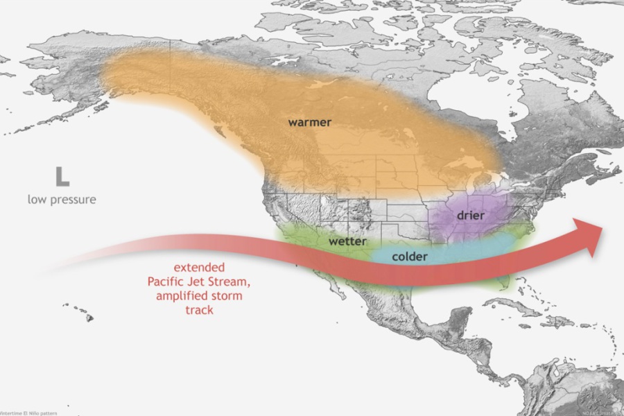 Typical influence of El Niño on North American winter weather and the jet stream – Image: NOAA Climate.gov / Fiona Martin
What is El Niño?
In simple terms, El Niño is a natural climate pattern that develops every few years when waters in the central and eastern Pacific Ocean become much warmer than usual. The trade winds that normally push warm water westwards weaken, allowing warmer water to move eastwards and build up across the Pacific.
These unusually warm waters alter tropical rainfall and atmospheric circulation, affecting weather patterns much further afield. The result can be an increased risk of wetter conditions in some regions and drier conditions in others, and can have a significant impact on weather patterns across North America.
This year’s El Niño developed in early summer, has strengthened rapidly since and is expected to peak towards the end of 2026 before weakening during 2027.
For more about El Niño, see our article about what the 2026–27 El Niño might mean for the Alps
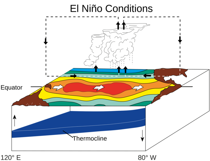 How El Niño alters ocean temperatures and atmospheric circulation across the tropical Pacific. Image: NOAA/PMEL/TAO, via Wikimedia Commons
How does El Niño affect winter weather in North America?
Historically, El Niño winters favour ski areas in the south-western United States, while the northern Rockies and Pacific Northwest tend to be less favoured.
During a typical El Niño (and even more so during strong events) the southern branch of the jet stream (i.e. the high-altitude winds that help govern the storm track across the Pacific) is likely to shift further south than normal.
This stronger southern branch of the Pacific jet stream is more likely to bring more frequent storms across the southern United States, while northern areas tend to experience milder and often drier weather conditions.
In terms of sea temperatures off the coast of South America, El Niño is expected to peak before the end of 2026. However, the influence of El Niño on North American weather patterns tends to peak later, with the strongest influence typically occurring in the middle part of the winter ski season (particularly between January and March).
This means that the chances of seeing the characteristic El Niño snowfall patterns may be greater later in the ski season than in November or December, although individual storms can occur at any time.
The map below shows historical tendencies for above or below-average snowfall during El Niño winters, and is not a forecast for winter 2026-27.
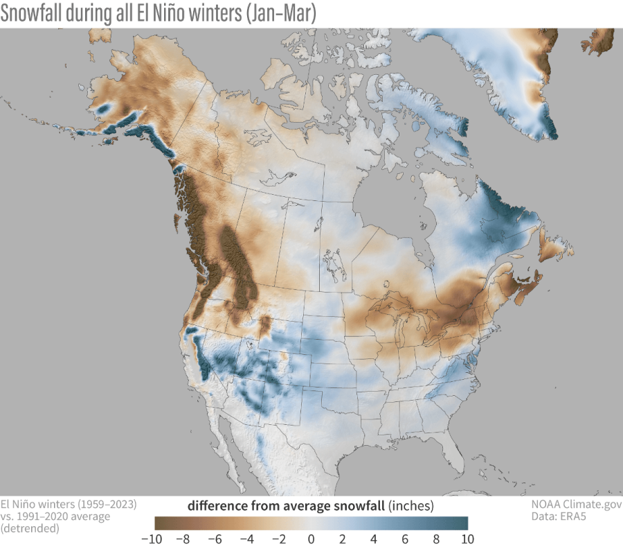 Historical snowfall patterns across North America during El Niño winters (January–March), showing areas that typically receive more or less snow than average – Image: NOAA Climate.gov
Which North American ski regions could benefit from El Niño in 2026–27?
With the storm track likely to be further south than normal during an El Niño event, it follows that the more southerly US ski resorts (including those in Arizona, California, New Mexico, southern Colorado and southern Utah) are most likely to benefit in terms of precipitation.
And, with the 2026 El Niño exceptionally strong, the chances of seeing these characteristic weather patterns are increased. However, even a very strong El Niño cannot guarantee particular outcomes for individual ski regions or resorts.
There is also a key caveat – greater precipitation doesn’t always mean more snow! Warmer storms can raise the rain/snow limit, particularly affecting resorts, ski areas or slopes at lower elevations.
So, which regions are most likely to benefit, and which may miss out?
California and the southern US
Historically, some of the strongest correlations between El Niño and increased precipitation have been found in the southernmost parts of the US. Resorts such as Arizona Snowbowl, Ski Apache in New Mexico, Brian Head in southern Utah and Mt Baldy in southern California are among the most likely to benefit from the typical El Niño storm pattern.
Other resorts that may benefit include Mammoth in California, Taos in New Mexico and Telluride in south-west Colorado.
The historical El Niño signal is generally less clear further north in the Sierra Nevada, meaning resorts around Lake Tahoe cannot necessarily expect the same benefits as those further south.
At higher altitudes, extra precipitation could mean very heavy snowfall, provided it stays cold enough. Storm tracks and temperatures will decide who gets the most.
Previous powerful El Niño events illustrate how this could go either way. While the El Niño winters of 1982–83 and 1997–98 brought exceptionally wet conditions to much of California, including heavy snowfall in the mountains, the strong 2015–16 El Niño failed to deliver during the latter part of the winter. So, not even the strongest El Niño events guarantee a particularly snowy ski season.
 Heavy snowfall in Mammoth, California, during the 2023–24 El Niño winter – Photo: facebook.com/mammothmountain, 2 February 2024
Utah and the central Rockies
Moving into the more central part of the Rockies, the historical relationship between El Niño and snowfall becomes much less clear-cut.
This region is likely to experience milder-than-average conditions, but the precipitation signal is far less clear. Major storms are still possible, but there is little to suggest that an El Niño event significantly increases or decreases the likelihood of above-average precipitation.
This includes many of the better-known Colorado and Utah resorts, such as Vail, Breckenridge, Aspen, Snowbird and Alta. Even with an exceptionally strong El Niño, there is no clear indication that these resorts will experience an unusually snowy or unusually poor winter..
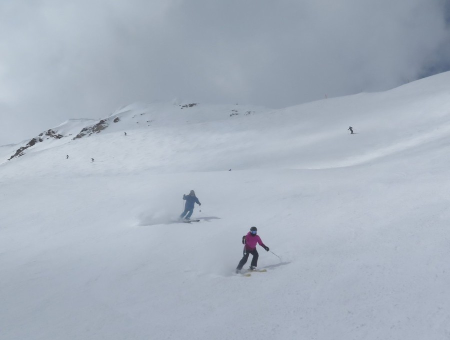 Fresh snow at Snowbird, Utah, during the 2023–24 El Niño winter – Photo: Tony Crocker, 11 March 2024
Northern Rockies, Pacific Northwest and western Canada
Further north, the typical El Niño influence tends to become less favourable for snowfall, stacking the odds in favour of a drier and, again, warmer-than-average winter.
This applies to northern Rocky Mountain resorts such as Big Sky in Montana, but particularly to the Pacific Northwest, including Mount Baker in Washington and Whistler in British Columbia.
Further into the Canadian interior, the Banff/Lake Louise area in Alberta also tends towards drier and milder conditions than normal during El Niño winters. However, its more inland, continental location may help offset some of the warmer temperatures that can affect ski resorts closer to the Pacific coast.
Of course, this doesn't mean these regions won't see major snowstorms or have a good ski season, just that the historical El Niño signal is less favourable overall.
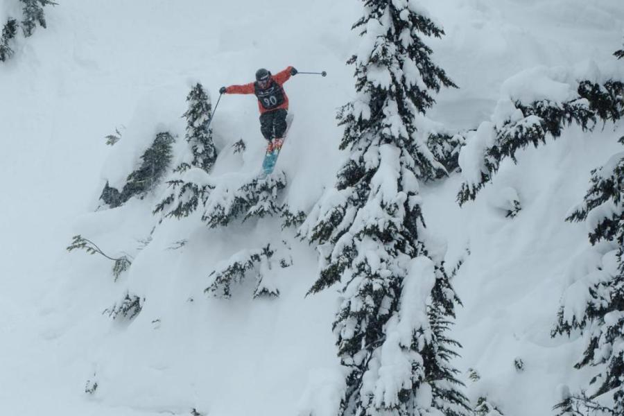 Deep powder snow in Whistler during the 2023–24 El Niño winter – Photo: Whistler Blackcomb, 15 March 2024
Alaska
Further north still, the influence of El Niño becomes more complicated.
Historically, much of Alaska has experienced below-average snowfall during El Niño winters, although it can favour increased snowfall in specific areas, such as Thompson Pass.
Eastern US and Canada
As for the ski resorts of eastern North America, in the eastern US, precipitation tends to lean towards above-average during El Niño winters, particularly further south. This could favour resorts such as Sugar Mountain in North Carolina.
However, the relatively low elevations of many eastern US ski areas mean that temperature is especially important, and rain is far more likely to prove an issue than in the western US.
Further north, eastern Canadian resorts such as Mont-Tremblant could experience drier-than-average conditions, although the outcome will still depend on the precise atmospheric patterns that develop during the winter.
Does a stronger El Niño mean more snow?
Not necessarily. Although a stronger El Niño makes the characteristic weather patterns more likely, other influences can override it. Short-term swings in the Arctic Oscillation (a pattern of atmospheric pressure variations around the Arctic that can influence the jet stream) can disrupt the storm track for weeks at a time, while the Pacific Decadal Oscillation (a slower pattern in North Pacific sea temperatures) can shape how El Niño plays out over a whole winter.
Individual storms can also take quite different tracks from those suggested by the overall seasonal pattern, as illustrated by the disappointing latter part of the 2015–16 El Niño winter in the south-western US. Even a powerful El Niño doesn’t necessarily produce the expected outcome.
And more precipitation doesn't always mean more snow. With a warming baseline pushing the rain/snow line higher up the mountain, temperature and altitude will ultimately decide how much falls as snow, particularly at lower elevations.
So, will El Niño bring more snow to North America in winter 2026–27?
This exceptionally strong 2026 El Niño does increase the chance of a more southerly Pacific storm track this winter, which would tend to favour ski resorts in the southernmost parts of the US, some of which may well see more snow than in an average winter.
Further north, though, El Niño generally points to a less favourable set-up for snowfall, while the likely outcome for resorts in the central Rockies is more of an unknown.
For now, the odds may be stacked more favourably for some regions than others, but we'll have to wait and see how winter 2026–27 actually unfolds. And, as any skier knows, a technically very snowy season doesn't necessarily mean a good one, particularly if much of that snow falls during just a handful of very disruptive storms.
Our snow reports will track the latest snow and weather conditions across the Alps and North America throughout the season.
Stay tuned!
If you enjoy reading our updates - please feel free to support us:
 Print