



Could the 2026 El Niño mean more snow for the Alps this winter?
by Fraser Wilkin, 30 September 2026
You may be wondering why we are writing about El Niño on a website about weather and snow conditions in the Alps, given that it is a natural climate pattern that mainly affects weather patterns
some distance away from Europe.
However, the 2026 El Niño is exceptionally strong – the Met Office has called it “unprecedented” and reported in September that it had already exceeded previous records – increasing its potential to influence weather patterns much further afield, including in Europe.
Inevitably, there has now been much talk about how El Niño could affect the Alps this winter.
Here we’ll break down the basics of El Niño, what it is and what it could mean for the 2026-27 winter ski season in the Alps…
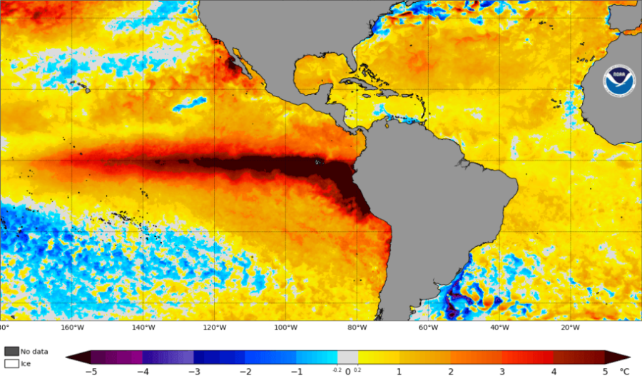 The exceptionally strong 2026 El Niño, with unusually warm water (dark red, up to 5°C above the 1991–2020 average) stretching across the equatorial Pacific – Image: NOAA Coral Reef Watch, 27 September 2026
What is El Niño?
In simple terms, El Niño is a natural climate pattern that develops every few years when the waters in the central and eastern Pacific Ocean become much warmer than usual, and changes in ocean temperatures and winds across the tropical Pacific reinforce one another.
During an El Niño event, the trade winds that normally push warm water westwards across the Pacific Ocean weaken, or sometimes even reverse. This allows warmer-than-normal water to move eastwards and build up in the central and eastern Pacific Ocean, including off the coast of South America.
The unusually warm Pacific waters shift patterns of tropical rainfall and atmospheric circulation, altering weather patterns much further afield. This increases the probability of heavy rainfall in some parts of the world, including the west coast of South America, the southern U.S. and parts of East Africa, while increasing the risk of drier conditions and drought in others, such as Australia, Indonesia and southern Africa.
This year's El Niño developed in early summer, has strengthened rapidly since, and is expected to strengthen further, peaking towards the end of 2026 before weakening again during 2027. It is already exceptionally strong, and now confirmed to be the strongest El Niño event since records began in 1950.
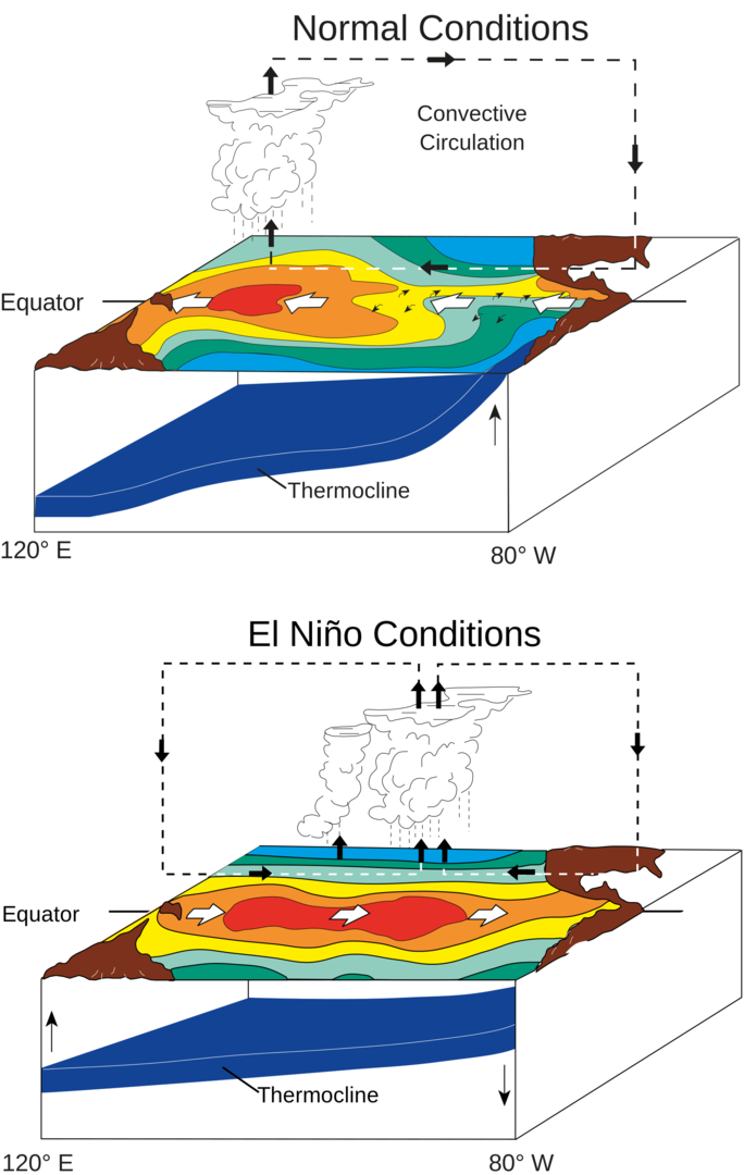 Images: NOAA/PMEL/TAO, via Wikimedia Commons
How does El Niño affect weather patterns in Europe and the Alps?
Compared with regions closer to the Pacific, the relationship between El Niño and European weather patterns is relatively weak and variable. However, there is evidence of a European "teleconnection" – essentially, a link between weather patterns in widely separated parts of the world – though the extent and nature of its influence on European weather also depends on other atmospheric and oceanic factors.
One way El Niño can influence European weather is through changes in North Atlantic circulation, where it can increase the chance of mild, wet and stormy weather across north-western Europe later in the autumn and into the early part of winter. Later in the winter, it can also increase the likelihood of colder weather patterns across western Europe.
There is some evidence that an exceptionally strong El Niño can strengthen these influences, although the relationship is not straightforward. In both cases, however, we are talking about an increased chance rather than a definite forecast.
At this stage, there is greater confidence in the signal for mild and stormy weather later in the autumn and into the first part of winter than in how the season may evolve further ahead, simply because of the uncertainties inherent in long-range forecasting. However, historically, El Niño years have shown an increased tendency towards colder weather patterns in western Europe later in the winter.
With that in mind, how might these patterns translate into snow conditions in the Alps during the 2026-27 winter ski season? Let's start with the early part of the season...
How could El Niño affect early-season snow in the Alps in 2026-27?
If we do see a prolonged spell of very mild but stormy weather later this autumn and into the first part of winter, an unusually mobile pattern with successive storms coming in from the Atlantic would be likely to deliver the greatest amounts of precipitation to the western and northern Alps. Regions most likely to be affected would include:
- the French Alps (except for the far south) – including the likes of Tignes-Val d’Isère, Paradiski, the Grand Massif and Chamonix;
- much of the Swiss Alps – including Verbier, Zermatt, Crans-Montana, the Jungfrau region and Laax;
- the north-western Italian Alps – including La Thuile, Courmayeur and Cervinia; and
- some northern and especially western parts of the Austrian Alps, such as the Arlberg region.
By contrast, regions most protected when the Atlantic is “fired up” and storms are coming from the west or north-west, and therefore less likely to be affected, would include:
- the far southern French Alps (e.g. Isola 2000);
- the south-western Italian Alps (e.g. Sauze d’Oulx);
- the central-eastern Italian Alps, especially the Dolomites; and
- the southern Austrian Alps, including resorts such as Nassfeld in Carinthia.
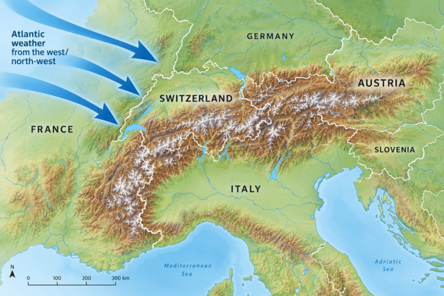 Atlantic weather from the west or north-west typically brings the heaviest precipitation to the western and northern Alps, while regions further south and east are often more sheltered.
Why would the western and northern Alps be most affected?
An enhanced Atlantic jet stream – essentially a stronger-than-usual band of fast-moving air high in the atmosphere that helps steer Atlantic weather systems into western Europe – can drive a succession of storms towards the continent, with the western/north-western Alps directly in their path.
However, the northern Alps (more generally) can also be affected, depending on the final track and the angle at which these Atlantic storms approach the Alps. This is determined not only by the position and strength of the jet stream, but also by the position of the Azores High – a semi-permanent area of high pressure, on average centred around the Azores but whose position can vary considerably.
When the Azores High remains far to the south-west of Europe, Atlantic storms can track relatively freely towards western Europe. However, when the high extends further north into the Atlantic (an 'Atlantic Ridge' set-up), it can help steer weather systems towards the Alps on a more north-westerly trajectory.
A north-westerly flow brings moist Atlantic air not only to the western Alps, but also directly into the northern side of the Alpine arc. When forced to rise over the mountains, this moist air can produce significant precipitation on both the northern and western slopes of the Alps.
A north-westerly attack on the Alps does not necessarily mean cold air, though. Active Atlantic storms often contain a ‘warm sector’ – a wedge of relatively mild, moist air – which can be drawn north-eastwards ahead of the low-pressure centre.
So, although the wind may be coming from the north-west by the time the storm reaches the Alps, the air mass arriving with it may have originated in the tropics and remain very mild. The important point is that the direction from which a storm approaches the Alps does not necessarily tell us where the air mass within it originated.
Will early-season precipitation fall as rain or snow?
A north-westerly set-up can deliver substantial precipitation to the northern and western Alps, but what is crucial for ski resorts is whether it falls as rain or snow, particularly at lower elevations. Indeed, some of the most significant rainfall events in the Alps can involve storms whose final approach is from the north-west.
How much of a problem the relatively mild air will pose for the lower ski resorts of the northern and western Alps will depend on the size of the warm sector, the track of the storm and the precise angle at which it hits the Alps.
A relatively small change in the storm track can make a significant difference to the altitude at which precipitation falls as rain rather than snow.
During an Atlantic storm, as fronts and warm sectors pass, freezing levels and rain/snow limits can also fluctuate considerably. During a mild, moisture-laden Atlantic storm, relatively small changes can make the difference between heavy rain and heavy snow falling at resort level, even while huge amounts of snow are falling higher up.
The rain/snow limit (i.e. the altitude at which rain turns to snow or vice versa) is usually below the freezing level (i.e. the altitude at which the temperature of freely circulating air, as opposed to the ground temperature, reaches 0°C). Snowflakes falling through the freezing level don’t necessarily melt immediately and can survive for several hundred metres below it, depending on varied factors including the vertical temperature profile or 'lapse rate' (i.e. how quickly temperature decreases with altitude), and the intensity of the precipitation. So, with a freezing level at 2000m, the rain/snow limit might typically be around 1600-1700m.
Note that the rain/snow limit is commonly referred to as the “snowline” in mountain weather forecasts, which can be confusing as it is also used to refer to the lower limit of snow cover on the ground.
Altitude is obviously very important in determining whether precipitation falls as rain or snow, but it is only one part of the equation. Exposure to the storm track, orientation, local topography, temperature profile and precipitation intensity all matter. A 2000m resort in the wrong part of the Alps isn't automatically better placed to receive snow than somewhere lower in a favoured region.
There are other complicating factors to watch out for too. When a warm front arrives in the Alps following a cold spell, cold air (being denser than warm air) can be hard to shift out of deep, enclosed valleys and can become trapped in the valley bottoms as warmer air glides over the top. This means that it may still snow to low levels there even if the general freezing level is much higher.
In the foothills this cold air can mix out relatively quickly, which is why the lower resorts of the north-western Alps, especially near the foothills, are at the highest risk of rain.
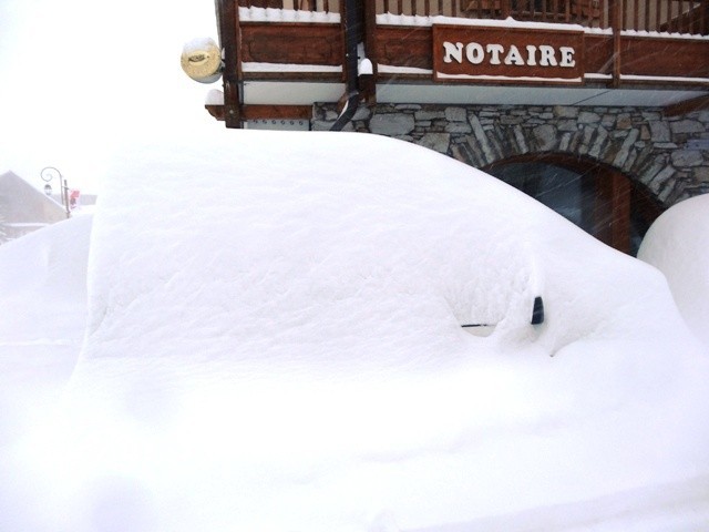 Could resorts like Val d’Isère see bumper early-season snowfalls like this during the 2026 El Niño? – Photo: weathertoski.co.uk
What could El Niño mean for the Alps later in the winter?
Historically, El Niño events can increase the probability of the weather in the Alps turning colder during the middle and latter part of the winter, with a greater chance of snow to lower altitudes.
This change towards colder weather is more likely during the latter part of the winter, particularly from late January through February and potentially into the first part of March. However, as with any links made between El Niño and the weather in Europe and the Alps, there are no guarantees. It is just an increased statistical probability based on historical patterns.
Even if colder weather does become more established, how much snow will actually arrive in the Alps depends on many other factors, including the behaviour of the Atlantic jet stream, the position of the Azores High and the position of the Siberian High – a large, semi-permanent system of high atmospheric pressure that forms over northeastern Eurasia from September until April – which tends to become more significant during the middle and latter part of the winter.
To maximise snowfall later in the season, a more established Atlantic Ridge set-up would be particularly favourable, with the Azores High extending further north into the Atlantic and becoming elongated on a north-south axis. This can allow a cold, dynamic north-westerly airflow to become established across the Alps, bringing the potential for widespread snowfall to relatively low levels, albeit with the northern Alps generally favoured.
If the Siberian High drifts west into Europe, however, it may introduce much colder air to the Alps. To generate precipitation though, you need both moisture and an appropriate storm track.
This cold, continental air can be relatively dry, meaning that it would not necessarily result in the same widespread snow that could be produced by the moister air brought in from a northward extension of the Azores High. However, some southern parts of the Alps could still benefit where the Mediterranean moisture meets that cold air.
The key point is that colder does not necessarily mean snowier: cold weather can also be dry, while wetter weather may bring plenty of snow at altitude but rain lower down.
The 'super-warm' Mediterranean sea wildcard
One additional wildcard for this coming winter is the temperature of the Mediterranean sea, which is exceptionally warm right now. Although this is not directly linked to El Niño, it could potentially “supercharge” Mediterranean storms later in autumn and the early part of winter, with a risk of extreme snowfalls in the southern Alps.
This is somewhat speculative, as there is no precedent for such high Mediterranean sea temperatures in combination with such a strong El Niño, and the areas most “at risk” will very much depend on the exact position of any Mediterranean storms produced.
However, the far south-western Alps (e.g. Prato Nevoso, Isola 2000), the eastern Monte Rosa region (e.g. Alagna), parts of Lombardy (e.g. Macugnaga, Madesimo) and the central-southern Dolomites (e.g. Arabba), are all susceptible to extreme snowfall with the right set-up, even in a “normal” year.
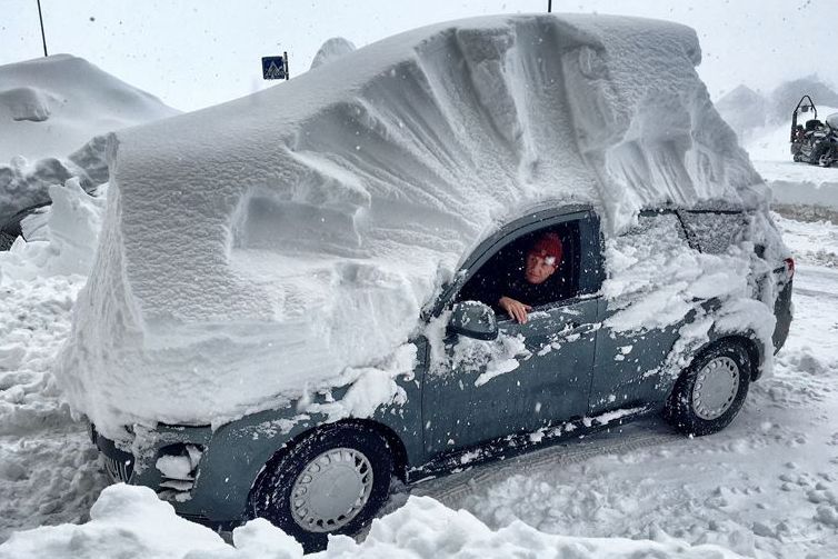 The southern Alps can see exceptional snowfall with the right set-up. This was Artesina, near Prato Nevoso, following one such event on 29 February 2016 – Photo: facebook.com/Dino.Bonelli, 1 March 2016
What happened in the Alps during previous strong El Niño winters?
Historically, El Niño has had a relatively weak and variable influence on Alpine winters, tending in some years to shift the Atlantic jet stream and European storm track southwards, increasing the potential for precipitation across western and southern Europe, and Mediterranean-influenced snowfall events in the Alps.
However, the North Atlantic circulation, particularly the NAO (North Atlantic Oscillation) – a weather pattern caused by shifts in the difference in atmospheric pressure between the Icelandic Low and the Azores High – often has a stronger influence on where storms actually track.
There is no simple “El Niño = snowy Alps” rule, as demonstrated by the three strongest previous El Niño winters of 1982/83, 1997/98 and 2015/16, which developed differently and produced very different weather patterns across Europe.
Weather to Ski did not exist for the first two of these winters, but contemporary records from the Swiss Institute for Snow and Avalanche Research (SLF) show that, in 1982/83, the Swiss Alps were generally snow-poor early in the season before a major snowfall in mid-January brought snow depths back towards normal, followed by very good skiing conditions in February and March. Records from the Austrian Alpine Club show that, in 1997/98, parts of the northern Alps enjoyed a reasonable start, but January and February became mild and dry (exceptionally so in February), before cooler and snowier conditions returned at altitude in March.
The most recent exceptionally strong El Niño winter, 2015/16, was different again. By then Weather to Ski was reporting extensively on Alpine snow conditions throughout the season. Interestingly, however, we did not identify El Niño as a significant driver of the weather patterns we were seeing at the time.
Our reports recorded an exceptionally poor start to the 2015/16 season, with very mild weather and severe snow shortages, particularly in the south. Conditions improved from January onwards, first at altitude in the north-western Alps, before snow became more widespread later in the season. March was colder than average and produced some of the best snow conditions of the winter.
So, even among these three exceptionally strong El Niño winters there was no consistent Alpine snowfall pattern: 1982/83 recovered dramatically from a poor start, 1997/98 saw an exceptionally mild and dry mid-winter, while 2015/16 eventually favoured the higher north-western Alps after another very poor start.
This makes the current 2026/27 forecast particularly interesting. Rather than the southern Alps being the obvious beneficiaries of the more southerly storm track sometimes associated with El Niño, the current expectation is for precipitation to favour the western and northern Alps, from the French Alps through Switzerland and into western Austria, with a weaker signal further south and across the Dolomites.
In that sense, winter 2026/27 may see a departure from that ‘classic’ El Niño pattern, although the difference may ultimately be explained by the precise position of the Atlantic storm track rather than El Niño itself.
So, while previous strong El Niño events provide some useful context, it is the combination of storm track and temperature that will determine how much snow the Alps actually receive this winter.
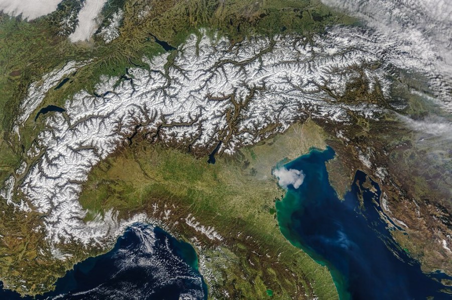 Snow across the Alps on 19 March 2016, late in the exceptionally strong 2015-16 El Niño winter – Image: NASA Earth Observatory / Jeff Schmaltz, NASA GSFC
Is climate change changing the picture?
Another key difference between previously strong El Niño events and the 2026 El Niño is that, as a result of climate change, temperatures in the Alps are now considerably warmer overall, meaning that precipitation which once fell as snow during previous strong El Niños can now increasingly fall as rain, particularly at lower elevations.
However, in terms of El Niño events themselves, it has not yet been definitively established that climate change is causing them to become stronger or more frequent.
What is clear is that El Niño is now occurring against the background of a warmer climate. Warmer oceans and a warmer atmosphere can amplify some of its impacts, including extreme heat and heavy rainfall in some regions, while increasing the severity of drought in others.
So, could this super El Niño mean more snow for the Alps in 2026-27?
Looking at all the available evidence, including the common themes running through the various winter forecasts issued by official or respected meteorological organisations, indications are that the exceptionally strong 2026 El Niño could influence Alpine weather this winter, particularly by increasing the chances of a mild, wet and stormy pattern during the early part of the season, although that may not automatically translate into more snow.
On balance, we think there is an increased chance of above-average snowfall in some parts of the Alps this winter, particularly at altitude in the north and west. The chances appear reduced at lower elevations and, more generally, across the southern and eastern Alps, although individual storms could still produce exceptional snowfall locally, particularly if an unusually warm Mediterranean comes into play. These scenarios are not predictions but possible outcomes based on statistical probabilities.
Current seasonal model guidance broadly supports the early-season signal for mild, wet and stormy weather, but seasonal forecasts themselves deal in probabilities and broad regional and seasonal averages. They cannot tell us exactly where individual storms will track, the direction from which they will approach the Alps or, crucially, where the rain/snow limit will sit. These are the factors that will ultimately determine which ski resorts benefit.
In terms of both the strength of this super El Niño and existing background conditions, including exceptionally high sea temperatures in the Mediterranean, we are in uncharted territory!
The most useful information will come from following the weather as it actually develops. Our Today in the Alps updates, weather & snow forecasts, and snow reports will track the latest snow and weather conditions across the Alps throughout the season.
Stay tuned!
If you enjoy reading our updates - please feel free to support us:

 Print