


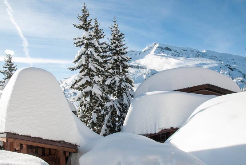
The complete guide to...
Snowfall patterns in the French Alps
by Fraser Wilkin, 16 September 2020
When it comes to the French Alps, explanations of snowfall patterns or weather forecasts can be confusing, not least due to the difficulty in making generalisations for a mountain range of such geographic extent and varied topography.
Broadly speaking, the French Alps can be divided into two climatic zones - the northern Alps and the southern Alps. However, references to “northern” and “southern” can be somewhat disingenuous as there is some degree of overlap between the two, and both regions also include numerous areas with microclimates of their own.
How do we define the "northern French Alps"?
We generally define the northern French Alps to include the departments of:
- Haute-Savoie - including resorts such as Morzine, Flaine and Chamonix;
- Savoie – including resorts such as Courchevel, Les Arcs and Val d’Isère; and
- Isère - including resorts such as Alpe d’Huez and Les 2 Alpes.
How do we define the "southern French Alps"?
We generally define the southern French Alps to include the departments of:
- Hautes-Alpes - including resorts such as Serre Chevalier and Vars;
- Alpes de Haute-Provence – including resorts such as Le Sauze, Pras-Loup; and
- Alpes Maritimes - including resorts such as Auron and Isola 2000.
Where is the dividing line between the northern and the southern French Alps?
The natural divide between the northern and southern French Alps is generally accepted to be the Col du Lautaret, or nearby Col du Galibier.
Close to this divide, Les 2 Alpes is one of the most southerly of the northern Alpine resorts (although you may occasionally hear it classified as southern Alpine), while Serre Chevalier is one of the most northerly of the southern Alpine resorts.
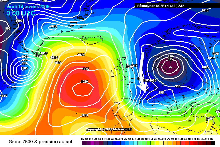
 The Col du Lauteret is commonly accepted as the dividing line between the northern and southern French Alps. Here the northern Foehn affect is visibly confining the bad weather to the north of the pass.
Which gets the most snow - the northern French or southern French Alps?
Average snowfall is generally higher (height for height) in the northern French Alps than it is in the southern French Alps, though this does not mean that it always has the better snow conditions. Far from it! The northern Alps are more susceptible to the warming influences of the Atlantic gulf stream and therefore have a higher risk of rain.
The highest average snowfall at resort level in France is found in Avoriaz, which gets about 7.5m a season. At high altitude, the area thought to have the highest snowfall average in France is the northern side of the Mont Blanc range (high above Argentière and Le Tour), with an estimated 15m+ close to 3000m.
In general, the average cumulative snowfall at 2000m per season (November to April inclusive) is between 5m and 8m in the northern Alps, and between 3.5m and 5.5m in the southern Alps.
 Avoriaz is the snowiest ski resort (at resort level) in the French Alps - Photo: avoriaz.com
Snowfall patterns in the NORTHERN French Alps
In the northern French Alps, most of the snow comes from the north-west and is associated with low pressure (i.e. a storm) centred somewhere to the north of the Alps, typically either over the North Sea or the low countries (i.e. Belgium, Holland and Luxembourg).
Significant snow can also arrive from the north, the west and even the south-west, however, it is much less likely (though not impossible) to come from the south or east.
When the weather in the northern French Alps is coming from the NORTH...
When the weather in the Alps comes from the north, these northerly winds can bring heavy snow showers to the northern and western foothills of the Alps, including regions such as the:
- Chablais (e.g. Morzine);
- Aravis (e.g. La Clusaz);
- Chartreuse (e.g. St Pierre en Chartreuse); and
- Vercors (e.g. Villard-de-Lans).
As northerly winds are usually cold, any snow they bring is likely to fall to low levels. However, heavy snow showers arriving on northerly winds will often have more trouble penetrating the more internal valleys, meaning that snow from northerlies will often be lighter and patchier in resorts such as Val d’Isère, Val Thorens and Val Cenis.
 Example of a cold northerly airflow over the Alps bringing snow showers to low levels, especially towards the northern and western foothills of the northern Alps (e.g. La Clusaz, Villard-de-Lans) – Image: meteociel.com, 14 February 2005
When the weather in the northern French Alps is coming from the NORTH-WEST...
While storms arriving from the north will typically deliver more snow to the northern and western foothills of the Alps, storms arriving from the north-west are more likely to deliver significant snow across the entire northern French Alps.
However, exactly where ends up getting the most snow depends on many factors, not least the potency of the storm and the type of weather fronts associated with it.
If the north-westerly flow is weak, the Haute-Savoie (e.g. Portes du Soleil, Flaine) will probably get the most snow. Whereas more powerful north-westerly storms will more evenly affect the Haute-Savoie and the Savoie (e.g. 3 Valleys, L’Espace Killy), although the Haute Savoie’s lower average skiing height means that any precipitation here can be more likely to fall as rain.
The resorts of the Isère (e.g. Les 2 Alpes, Alpe d’Huez) can also get significant snow from north-westerly storms but generally not as much as their Savoyarde neighbours.
 Example of a powerful north-westerly airflow across the Alps bringing snow to low levels across all northern parts of the French Alps – Image: meteociel.com, 22 February 1999
When the weather in the northern French Alps is coming from the WEST...
Forecasting can be tricky in the northern French Alps when the weather comes from the west, as westerly airflows can lead to huge variations in rain/snow limits. However, in terms of quantity of precipitation, they do tend to favour the higher mountains of the eastern Haute Savoie (e.g. Mt Blanc) and the eastern Savoie (e.g. Val d’Isère, Les Arcs, Val Thorens).
Sometimes a westerly flow includes a warm front dragging air of subtropical origin across the Alps. This warm front will try to displace the colder air already in situ over the Alps but, as cold air is denser then warm air, it can be very difficult to dislodge that cold air from some of the more enclosed/internal valleys such as the Haute-Tarentaise.
So you may have a situation where rain is falling to 2000m or higher in exposed resorts such as Avoriaz or Alpe d’Huez (both around 1800m in altitude), while it continues to snow lower down in the more “internal” town of Bourg St Maurice (at around 800m).
Powerful warm fronts will eventually mix out all the cold air, especially if it is windy, so the rain/snow limit will become more consistent. Warm fronts have been known to raise the rain/snow limit to 2500m or higher in the northern French Alps, even in mid-winter.
 Example of a powerful westerly airflow, not especially cold, but bringing heavy snow to much of the northern Alps, especially to the higher resorts of the Tarentaise (e.g. La Rosière) – Image: meteociel.com, 16 January 2018
When the weather in the northern French Alps is coming from the SOUTH-WEST...
When the weather comes from the south-west, the south-westerly airflows can deliver heavy snow to the northern French Alps, tending to favour the Isère (e.g. Alpe d’Huez) and parts of the Haute-Savoie, especially the Chablais (e.g. Portes du Soleil). However, they are quite likely to also deliver rain lower down, especially in the early stages of a south-westerly storm.
The big resorts of the Tarentaise (e.g. Les Arcs, Val d’Isère) are less favoured when the wind comes from the south-west as they are “protected” by the Foehn, meaning that the weather will stay dry for longer – often until the weather front actually passes overhead and the wind switches direction.
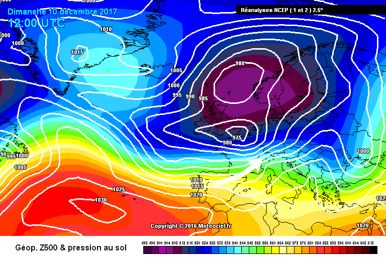 Example of a relatively cold south-westerly airflow with an airmass of Polar origin, where the inner Alpine valleys (e.g. Tarentaise) would initially be protected by the Foehn – Image: meteociel.com, 10 December 2017
When the weather in the northern French Alps is coming from the SOUTH...
When the wind comes from the south, the southerly airflows are unlikely to bring significant snow to the northern half of the French Alps, instead creating a Foehn wind that generates mostly dry, very mild, windy and rather cloudy weather (with some sunny intervals).
Areas of the northern French Alps most likely to see any snow from a southerly airflow are the Haute-Maurienne (e.g. Val Cenis) and the extreme south-east of the Haute-Tarentaise (e.g. Val d’Isère), especially if the wind flow veers slightly towards the south-east allowing precipitation to spill across the border from Italy.
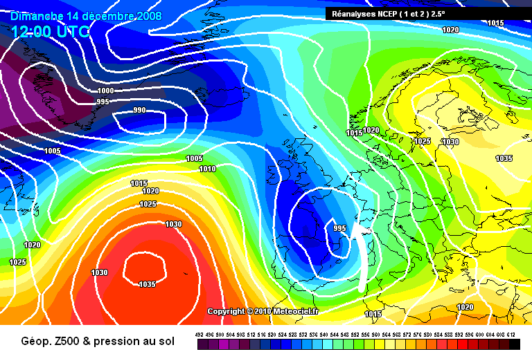 Example of a southerly airflow which will keep most of the northern Alps dry due to the Foehn effect – Image: meteociel.com, 14 December 2008
When the weather in the northern French Alps is coming from the EAST or SOUTH-EAST...
When the wind is coming from the east or south-east, the weather in the northern French Alps is mostly dry, but there can be flurries here and there, especially close to the Italian border.
These easterly or south-easterly airflows may also lead to a phenomenon called the 'Retour d’Est' (‘return from the east’) which can bring heavy snow to the Haute-Maurienne (e.g. Bonneval, Val Cenis) and far south-east of the Savoie (e.g. Tignes, Val d’Isère). The Retour d’Est has been known to deliver well over 1m of fresh snow in 24 hours to the high border areas just south of Val d’Isère.
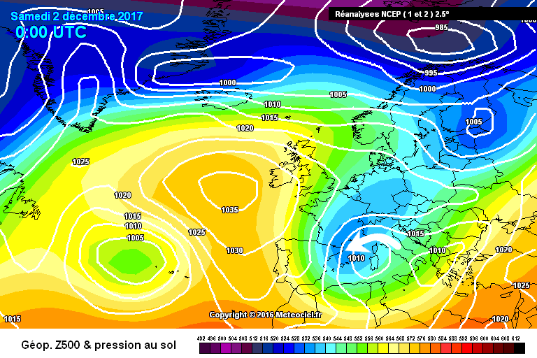 Example of a ‘Retour d’Est’ which, in the northern French Alps, would only bring snow to the far south-eastern Savoie (e.g. Val d’Isère, Val Cenis) – Image: meteociel.com, 2 December 2017
When the weather in the northern French Alps is coming from the NORTH-EAST...
On average, the weather in the northern French Alps will be coldest when the winds are coming from the north-east. While these north-easterly winds may bring some snow flurries, most likely in in the border areas of the Haute-Savoie (e.g. Avoriaz), most of the northern French Alps will stay dry.
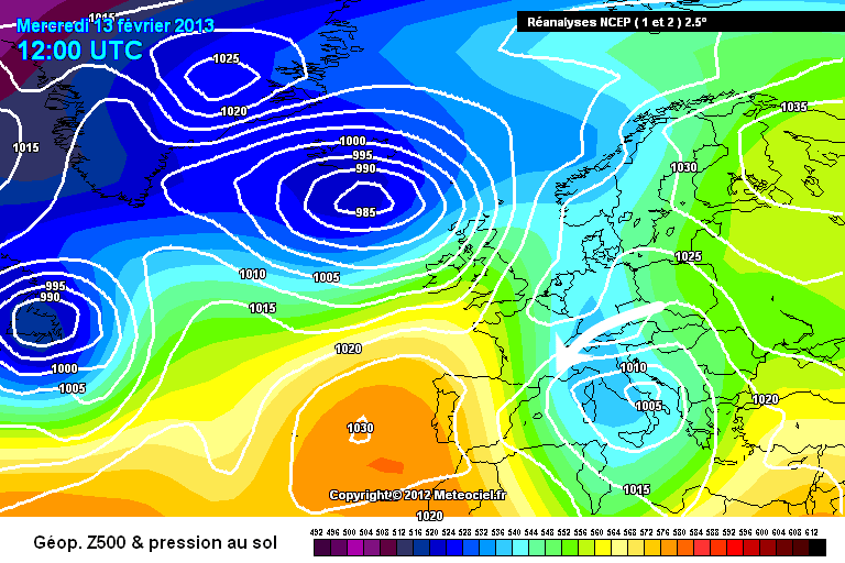 Example of a cold north-easterly airflow across the French Alps which may bring a few snow flurries to some border regions, notably the Haute-Savoie (e.g. Avoriaz), although most areas would stay dry – Image: meteociel.com, 13 February 2013
Snowfall patterns in the SOUTHERN French Alps
In the southern French Alps, the most significant snowfalls are generated when the weather comes from between the west and south. The one major exception is the border areas of the far south-east of the French Alps (e.g. Isola 2000 and the Queyras) which get their biggest snowfalls from the east or south-east in a phenomenon known as the “Retour d’Est”.
Some northern parts of the southern French Alps can also get snow from the north-west (e.g. SuperDévoluy, Serre Chevalier), but quantities are generally not that large.
When the weather in the southern French Alps is coming from the NORTH...
Significant snow is almost impossible in the southern French Alps when the weather comes from the north. Although some light flurries may get as far as the Col du Lautaret, the weather will generally be cold and dry.
 Example of the wind coming straight from the north, where most of the southern Alps would stay dry and bright with only the chance of a light flurry in the extreme north of the southern Alps (Col du Lautaret) – Image: meteociel.com, 14 February 2005
When the weather in the southern French Alps is coming from the NORTH-WEST...
Weather coming from the north-west does not generally lead to significant snowfall in the southern French Alps, although a powerful “north-westerly” storm can bring significant snow to some northern parts (e.g. SuperDévoluy, Serre Chevalier).
Any snow from the north-west is likely to be lighter and patchier the further south and south-east you are, with resorts such as Isola 2000 remaining virtually untouched.
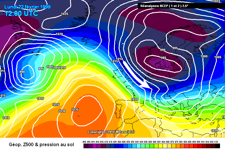 This vigorous north-westerly airflow would allow some snow showers into the northern part of the southern French Alps (e.g. Montgenèvre), but the rest would remain dry with the best of any sun in the far south-east – Image: meteociel.com, 22 February 1999
When the weather in the southern French Alps is coming from the WEST...
Weather coming from the west can bring significant snowfall to many parts of the southern French Alps, although particularly big snowfalls are unlikely and the rain/snow limit may be high in the west (e.g. SuperDévoluy, Orcières-Merlette).
The far south-east (e.g. Isola 2000, Auron) will generally see the lightest and patchiest snow from a westerly airflow.
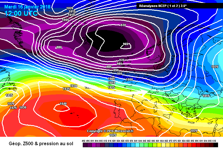 Example of a vigorous westerly airflow bringing some snow to higher parts of the southern French Alps, especially in the west (e.g. SuperDévoluy), but leaving the far south-east (e.g. Isola 2000) dry – Image: meteociel.com, 16 January 2018
When the weather in the southern French Alps is coming from the SOUTH or SOUTH-WEST...
The south or south-west is the best direction for the weather to be coming from to generate widespread heavy snow across the southern French Alps.
The rain/snow limit will depend on how much cold air is already in place in the area before the southern or south-westerly storm arrives. If there is plenty of cold air to tap into, snow may fall to very low altitudes. If not, the rain/snow limit will rise, sometimes up to 1500-2000m or higher.
Two resorts that usually do very well from a powerful south-westerly flow are Serre Chevalier and Puy St Vincent, while areas further south (e.g. Reallon, Isola 2000) will be likely to do better from weather arriving on a more direct southerly approach.
 Example of a vigorous and relatively cold south-westerly airflow, which would bring heavy snow to much of the southern French Alps (e.g. Serre Chevalier, Risoul) but may leave the far south-east (e.g. Auron) dry – Image: meteociel.com, 10 December 2017
 A direct southerly airflow can bring widespread snow to the southern French Alps but will generally most favour areas closest to the Mediterranean (e.g. Reallon, Isola 2000) – Image: meteociel.com, 14 December 2008
When the weather in the southern French Alps is coming from the EAST or SOUTH-EAST...
When the weather comes from the east or south-east, most areas of the southern French Alps will be dry and cold.
A major exception to this is the border areas with Italy, and particularly the resorts of the Queyras and the Mercantour (e.g. Isola 2000) which can receive huge snowfalls from the 'Retour d’Est' phenomenon.
 This 'Retour d’Est' was generated by a storm centred over the Gulf of Genoa, bringing heavy snow to areas near the Italian border, especially the Queyras (e.g. Abriès) and Mercantour (e.g. Isola 2000) – Image: meteociel.com, 2 December 2017
When the weather in the southern French Alps is coming from the NORTH-EAST...
When the wind is coming from the north-east, the weather in most areas of the southern French Alps will be cold, dry and sunny. However, the north-easterly airflow may bring a few snow flurries to the border regions with Italy.
 Example of a cold north-easterly airflow which might bring the odd flurry to some border region (e.g. Montgenèvre), but leave most other areas dry and bright – Image: meteociel.com, 13 February 2013