Season Progress Report: 3 December 2025
by Fraser Wilkin, 3 December 2025


Got a burning question about weather or snow conditions in the Alps?
Contact us and we'll do our best to answer it...
by Fraser Wilkin, 3 December 2025
It’s early December. More and more resorts across the Alps are opening, and there appears to be quite a lot of snow in places.
But just how good are early season snow conditions? Is it really one of the best starts in recent memory? Can we believe all the hype we have seen in the last week or two?
Here, in our first Season Progress Report of winter 2025-26, we will cut through the noise and unpack what is really going on in the Alps as we approach the main part of the season...
 Late November snowfall was exceptional in the north-western Alps. This is Glacier 3000 which saw around 1.5m of snow in just 3 days at the end of November – Photo: facebook.com/glacier3000, 26 November 2025
Broadly speaking, snow conditions in the Alps are pretty good for early December. However, last week’s exceptional snowfalls were confined to the north-west, and there is nothing remarkable about snow conditions in most other parts of the Alps – indeed further south and east, snow depths are often below par for the time of year, not above.
So, what’s going on? First a little recap on how we got to where we are now...
This autumn in the Alps was not far off average in terms of temperature overall, with a slightly warmer than normal September, slightly cooler than average October, and close to average November.
However, November was a month of two halves, beginning very warm but then turning colder mid-month. Precipitation-wise this autumn in the Alps was wetter than average in the north, but drier in the south.
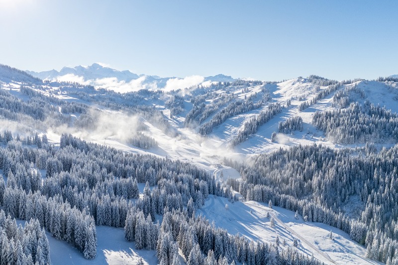
Although by mid-November there was already some lying snow in the Alps at altitude, especially in the north, things didn’t get interesting until the last couple of weeks of November. This is when the weather in the Alps turned notably colder and snowier, especially in the north-west.
This wintrier spell of weather culminated in the now well-documented big storm of 23-26 November.
The 23-26 November storm most favoured the French Alps (e.g. Val d’Isère, La Rosière, Avoriaz), the far north-western Italian Alps (e.g. Courmayeur, La Thuile) and the far western Swiss Alps (e.g Portes du Soleil, Villars, Gstaad, Glacier 3000).
These regions all saw well over 1m of fresh snow at altitude in just 3 days, with over 1.5m in some favoured spots.
 The upper Aosta Valley in north-west Italy has seen huge early season snowfalls. This is Courmayeur – Photo: facebook.com/MeteoVDA, 26 November 2025
More significant perhaps, especially in the context of recent years, is how much snow fell at lower altitudes.
By the end of November, resorts like Morzine, Les Gets, Megève, La Clusaz, Villars, Gstaad and Grindelwald (to name just a few) had more snow on the ground at resort level than at almost any time during the last couple of winters, let alone this early in the season!
 We haven’t seen this much snow at low altitudes in Les Gets very often in recent years at any point in winter, let alone in late November – Photo: facebook.com/LesGetsOfficielle, 27 November 2025
So, in these lower ski resorts, the snow levels right now are still unusually good. You would probably have to go back to 1996 to find similar snow levels this low in the north-western Alps at the end of November/start of December!
Higher up in the north-western Alps (in Val d’Isère, for example), snow levels are also good, but just but not as unusually good as they are lower down.
But with 3 weeks to go until Christmas, have these lower resorts of the north-western Alps peaked a bit early?
Looking at the weather models, we are unlikely to see any major snowfalls in this region (or in many parts of the Alps) for quite some time. Although there is plenty enough snow to carry these lower ski resorts through into the main part of the season, it is likely that early snow conditions in the north-west, albeit still impressive, will slowly lose the “extraordinary” tag over the next week or two.

As for elsewhere in the Alps, snow depths are generally unremarkable – but that doesn’t mean that there isn’t still plenty of good skiing. The late November storms brought enough colder air to allow at least some snow to settle to low levels across many (if not quite all) parts of the Alps.
Although some of this low-level snow has now disappeared again, it did for a while at least, allow most of the Alps to feel like winter had hit early and hit hard.
And, even if snow depths are modest, the relatively low and stable temperatures of recent days mean that snowmaking has been operation at full throttle across the Alps, and on-piste skiing remains generally good.
The region with the least snow is perhaps the central-southern Austrian Alps, just south of the main Alpine ridge (e.g. Kals and Heiligenblut).
Indeed, many internal valleys deep in the Alps are considerably below par snow-wise, including Zermatt, the Monte Rosa region and Ischgl – although the altitude of these areas (combined with snowmaking) means that most pistes are still in good shape.
 There’s not as much snow in the Austrian Osttirol and northern Carinthia regions as elsewhere in the Alps. This is Heiligenblut – Photo: foto-webcam.eu, 3 December 2025
Here is a brief run-down of the progress of the 2025-26 ski season country by country:
The best snow cover in Austria relative to altitude is currently in the Arlberg region (e.g. Lech, St Anton) where snow depths are above average for the time of year.
Elsewhere, snow levels are generally reasonable for the time of year, at least across the northern Austrian Alps where there is still snow to quite low levels (e.g. Kitzbühel), even if overall snow depths remain fairly modest.
Some central-southern Austrian ski resorts just south of the main Alpine ridge (e.g. Heiligenblut) are a bit threadbare, but we should stress that this is not unusual for early December.
Overall, the picture for Austria is a solid (rather than spectacular) start to the 2025-26 ski season.
 Snow right down into the lower valleys in the northern Austrian Alps. This is St Johann in Tirol – Photo: foto-webam.eu, 3 December 2025
As things stand, France has the best snow conditions of the main Alpine countries, with generally above snow depths for early December.
This is especially true in the northern French Alps where even lower resorts (e.g. Les Gets, La Clusaz) are unusually snowy for the time of year.
The southern French Alps (e.g. Serre Chevalier, Risoul, Isola 2000) have more modest snow depths overall, though conditions are still decent for the start of December. At the time of writing, this region is also picking some fresh snow, especially Isola 2000.
Overall, the French Alps have made an excellent start to the 2025–26 ski season, especially in the north.
 Excellent early snow conditions in Flaine – Photo: facebook.com/officedetourismeflaine, 3 December 2025
Italy has very impressive snow depths in the far north-west (e.g. Courmayeur, La Thuile) thanks to last week’s storms. There is also good cover in the extreme south-west (e.g. Limone Piemonte, Prato Nevoso) thanks to the snowfall it is getting at the time of writing.
Elsewhere in the Italian Alps, snow cover is more average for the time of year, albeit a bit sparse in some high inner-Alpine regions like the Monte Rosa. That said, Italy’s world-class snowmaking means that there is a lot of good piste-skiing on offer in areas with relatively little natural snow.
Overall, the Italian Alps have made an excellent start to the 2025–26 ski season in the far north-west, but a steadier start elsewhere.
 The Dolomites have solid, rather than spectacular, snow conditions right now. This is Alta Badia – Photo: foto.webcam.eu, 3 December 2025
Switzerland has excellent snow cover in the far west (e.g. Portes du Soleil, Villars, Gstaad), and above average snow cover in some northern resorts like Mürren and Engelberg.
Snow conditions are less impressive in the south and east of the Swiss Alps though, with generally below average snow cover in resorts like Zermatt and St Moritz, though we should again stress that it is very early days.
Overall, the Swiss Alps have made an excellent start to the 2025–26 ski season in the far west and some northern regions, but elsewhere snow depths are far more modest.
 Early season snow depths are above average in Mürren in the northern Swiss Alps – Photo: facebook.com/MurrenAlps, 27 November 2025
If you enjoy reading our updates - please feel free to support us:


