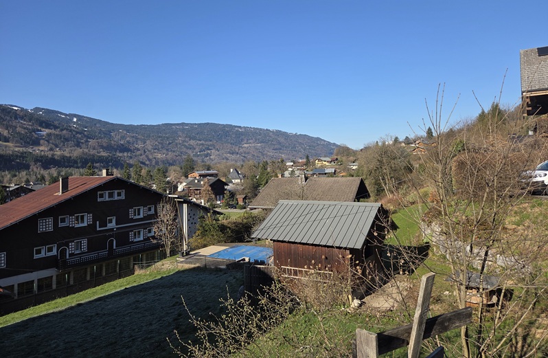
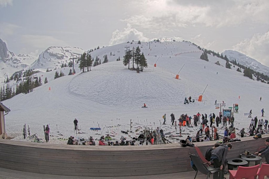
Weather to ski is still in Wengen where, with a major new storm approaching from the north-west, we got extremely lucky with the weather today.


Got a burning question about weather or snow conditions in the Alps?
Contact us and we'll do our best to answer it...
Updated: 5pm Monday 30 March 2026 – New storm moving in from the north-west...
Weather to ski is still in Wengen where, with a major new storm approaching from the north-west, we got extremely lucky with the weather today.
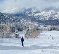
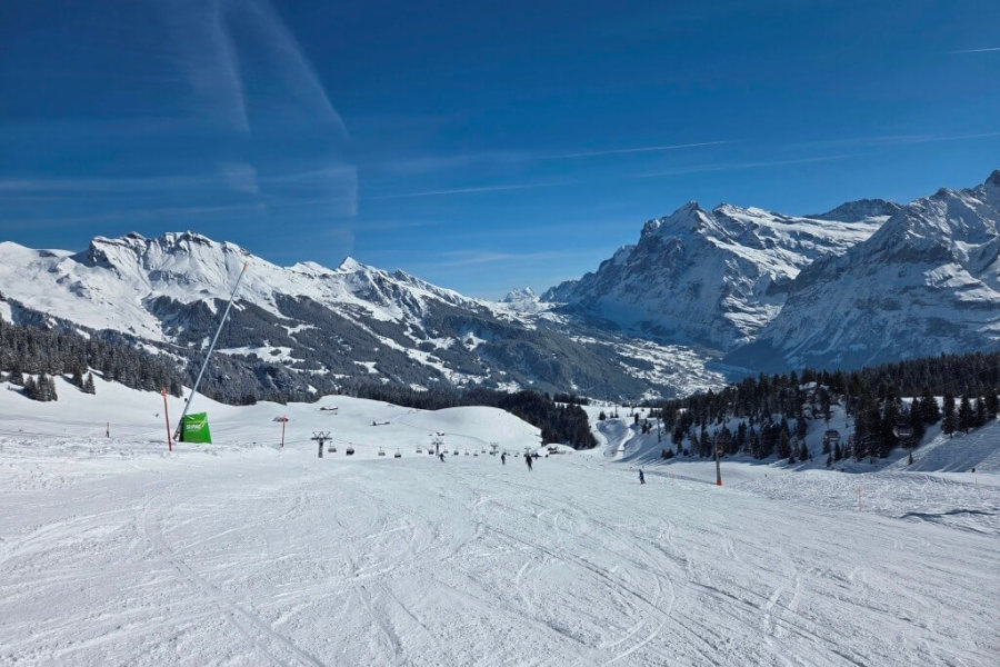
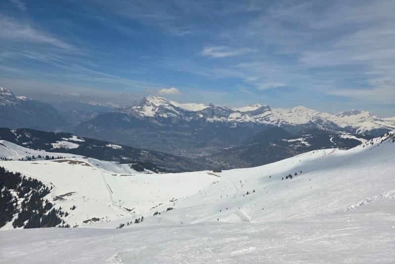
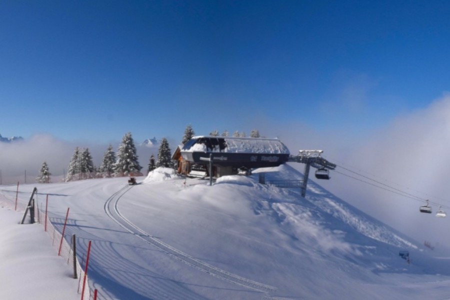
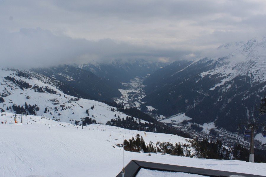
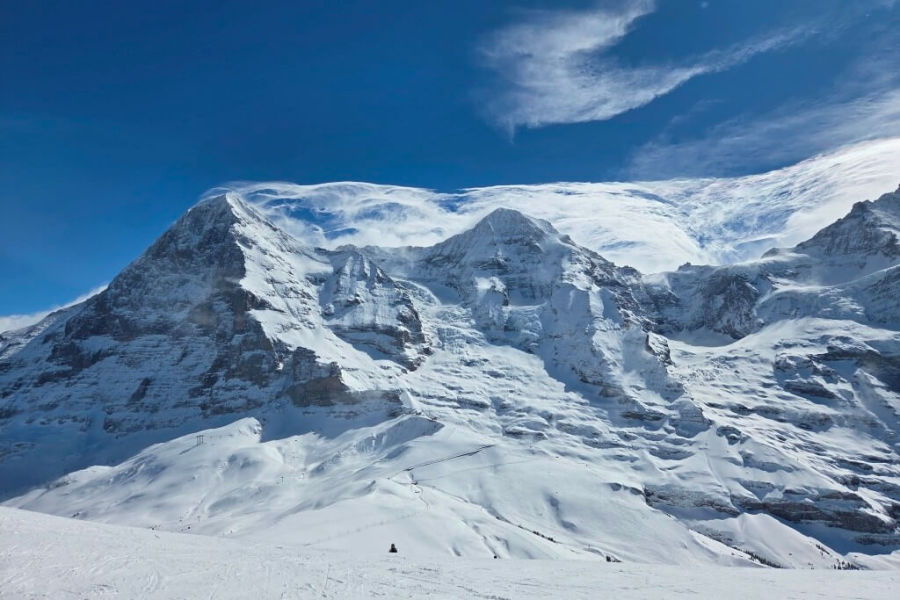 Sunny break today in Wengen, but tell-tale signs that change is afoot with the weather, with swirling cloud formations on the summits of the Eiger, the Mönch and the Jungfrau – 30 March 2026 – Photo: weathertoski.co.uk
Although it was foggy and windy at altitude first thing, the sun broke through for a couple of hours during the middle of the day, allowing for some wonderful cruising on empty, powdery pistes. Once again, spring snow was really only evident on the lowest parts of the ski area, below 1400m or so, with winter still firmly in control at altitude.
This evening it is snowing again, with falls expected to continue all night and well into tomorrow. Here in Wengen we are expecting at least 40cm at altitude by tomorrow afternoon, with 40-60cm forecast quite widely across the northern Swiss Alps from about the Jungfrau Region eastwards, including areas like Engelberg, Stoos and Braunwald.
However, snowfall totals in Austria have been revised downwards in the last 24-36 hours, with 50cm possible in the Arlberg but more likely 15-30cm for most of the northern Austrian Alps.
The northern French Alps will see more like 5-15cm, with the southern Alps seeing much less or, in some cases, no new snow from this latest storm.
Fantastic late season snow conditions in the northern Alps...

Big storm about to hit the western Alps!
If you enjoy reading our updates - please feel free to support us:


The 2024-25 North American ski season saw slightly below average snowfall overall, but the Northeast had its snowiest season since 2016-17.
Read our full review of the 2024-25 ski season, and find out who got the most snow in North America...
The 2022-23 alpine ski season was relatively snowless and exceptionally mild, although some resorts fared better than others.
Read our full review of the 2022-23 ski season and find out who got the most snow in the Alps...

Bad Gastein: 5 reasons to visit this 'forgotten' Austrian gem
23 March 2024
Bad Gastein dropped off the radar for a while with British skiers but is now making a comeback. Here are 5 reasons why you should consider it for your next ski trip...
Top 5 pistes in Les Arcs
8 June 2022
Les Arcs boasts some of the finest and most famous pistes in the Alps. Here are five of our favourites...
Top 5 early season ski resorts - Italy
22 October 2020
Here are our top 5 ski resorts for an early season ski holiday in Italy...
Snowfall patterns in the French Alps
16 September 2020
Ever wondered why some areas of the French Alps get more snow than others?
Updated: 7.30pm Sunday 29 March 2026 – Still feeling wintry in the northern Alps...
Weathertoski is in Wengen in the Jungfrau region of Switzerland where it was mostly cloudy today with a few very light flurries and freezing levels around 1200m, which is cool for the time of year.
 Still feeling wintry in Wengen this morning, with cold temperatures and another 10cm of fresh snow overnight – 29 March 2026 – Photo: foto-webcam.eu
Although there was some slush on the lowest slopes above Grindelwald and on the home run into Wengen, packed powder was the order of the day across most of the area and away from the valley bottoms it still felt very much like winter.
Elsewhere in the Alps there was a lot of cloud across most other northern regions, but plenty of sunshine in the south.
Another weather front will reach the northern Alps later , bringing further snow to relatively low levels, heaviest in Switzerland and Austria. This will continue into and .
Between and , we can expect around 5-20cm of fresh snow in the northern French Alps, around 20cm in the far western Swiss Alps (e.g. Verbier), 50-80cm across the northern and eastern Swiss Alps (e.g. Mürren, Engelberg, Braunwald) and the northern and western Austrian Alps (e.g. Kaprun, St Anton). Some spots (e.g. Engelberg, Lech) could again see something close to 1m.
The rain/snow limit could briefly rise to 1000-1200m before lowering to around 500-700cm from .
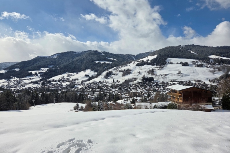
Updated: 7pm Saturday 28 March 2026 – Great late season snow conditions in the northern Alps...
Weathertoski is currently in Wengen, where late season snow conditions are excellent, with more snow falling this evening after a largely sunny but still relatively cold day, with the cloud only really thickening up from mid-afternoon before the first flakes fell at around 4pm.
 Fabulous late season snow conditions in Wengen in the Swiss Jungfrau region – 28 March 2026 – Photo: weathertoski.co.uk
This snow comes courtesy of a cold front that is moving in from the north-west and is expected to deliver 5-15cm quite widely across the north-western Alps by . Some northern Swiss Alpine areas (e.g. Jungfrau Region, Engelberg) could even see 20-30cm. Later the rain-snow limit will descend from around 900-1200m to 500m.
On , any snow will die away from the northern Alps but further weather fronts will affect the northern Alps on and , with Switzerland and Austria set to be most favoured in terms of snowfall.
Late season snow conditions in the Alps are generally excellent, especially in the northern Alps which saw a lot of snow just a few days ago. Temperatures have also remained low, meaning that the snow has stayed “wintry” to surprisingly low altitudes for much of the day.
Here in Wengen we skied on excellent packed powder for most of the day, with firm snow even all the way down to Grindelwald this afternoon!
Updated: 7pm Thursday 26 March 2026 – A late taste of winter for much of the Alps...
Weathertoski is in Megève where we woke up to around 10-15cm of snow and sub-zero temperatures this morning. There were further flurries today, albeit lighter than expected, with very little added to the overall storm total of around 30cm higher up.
 Snowy scenes as the sun returned this afternoon in Megève – 26 March 2026 – Photo: weathertoski.co.uk
Elsewhere in the Alps there has also been significant snow, most of it (as expected) in the northern half of the Alps but with some further south too, especially close to the border areas and in the Dolomites.
The heaviest snow has, however, fallen in the northern Swiss and western Austrian Alps where some favoured spots have seen 70-100cm, including near Engelberg and in the Austrian Arlberg/Vorarlberg.
Not only was this storm impressive for the quantity of snow it delivered (at least to parts of Switzerland and Austria) but also in terms of how low the snow fell – down to 300-400m in places early this morning.
Snow flurries to low levels will continue for a time across some northern parts of the Alps tonight, especially in eastern Switzerland and Austria. By tomorrow they will be mostly confined to the northern and eastern Austrian Alps (e.g. Schladming).
Saturday will be mostly fine, if still rather chilly, but a new cold front will reach the north-western Alps later in the day, delivering some modest quantities of snow to parts of the French and western Swiss Alps on Saturday evening.
Further fronts will approach the northern Alps early next week, with the chance of some further very significant snowfalls for some northern parts of the Alps, especially in the north-east (i.e. Austria).
Updated: 7pm Wednesday 25 March 2026 – The storm has arrived in the northern Alps...
Weather to ski is in Megève where the weather today played out more or less as expected – starting out sunny before clouds started to roll in from the west mid-morning.
 Snow falling at resort level in Megève late this afternoon – 25 March 2026 – Photo: weathertoski.co.uk
The first light showers broke out here around 2-3pm with a rain/snow limit initially around 1400-1500m. However, it started to turn to snow at resort level (1113m) at around 4pm with the snow becoming heavier and sticking (on the grass at least) at around 5pm.
The temperature in the village today dropped from 11˚C at 2pm to just 1˚C by 5pm!
 Skiing on the Rochebrune side of Megève this morning before the storm came in – 25 March 2026 – Photo: weathertoski.co.uk
, we are expecting around 15cm here at resort level, with perhaps 25-30cm higher up, with a rain/snow limit descending to 400-500m later. Snow flurries are then expected to continue to very low levels throughout much of , albeit becoming lighter and more intermittent later in the day.
As for the rest of the Alps, roughly speaking, between 20-40cm of fresh snow can be expected above 1500m in the northern French Alps by , with between 30-60cm in both the northern Swiss Alps and northern Austrian Alps. As usual, some “hotspots” will see a bit more, with Engelberg as likely as anywhere to hit 70cm+ at altitude.
The southern Alps will see less snow although some areas will still pick up some useful top-ups, especially close to the border regions (e.g. Cervinia, Livigno) and even the Dolomites, with most of that snow coming .
On , flurries should have died away from the north-western Alps but may continue for a time across more north-eastern regions, especially the eastern Austrian Alps. The southern Alps will be mostly sunny, but it will still be cold everywhere.
Over the and into the , further weather fronts will affect the northern Alps with some additional snow in places, but not in the kind of quantities that will be seen from the current storm.
Updated: 7pm Tuesday 24 March 2026 – Major “northerly storm” on queue to hit the Alps later tomorrow...
Weather to ski is in Megève, where it was largely sunny but not excessively warm today with some great spring-skiing conditions on offer.
 Still lots of snow at altitude in Megève, where snow conditions are excellent for late March – 24 March 2026 – Photo: weathertoski.co.uk
Snow conditions in Megève today were surprisingly good for late March thanks to the relatively low freezing levels (around 2000m). This allowed the snow to stay firm all day long on north-facing slopes above about 1700m, with some great corn snow in other areas depending on the time of day.
The sunnier Jaillet side of the ski area is now closed but it is still possible to ski to 1200m or so on in the other sectors.
 Enjoyable spring skiing conditions in the trees in Megève today – 24 March 2026 – Photo: weathertoski.co.uk
we are expecting a dramatic change in the weather in the Alps, with the arrival of an active cold front that will reach the north-western Alps during the afternoon. It will quickly cross the rest of the Alps on , followed until by a strong ‘Nordstau’ – i.e. precipitation from orographic blocking on the northern side of the Alps.
The rain/snow limit will start at around 1000-1500m but will quickly drop to 700-900m in the north-western Alps in the evening, then to 300-600m overnight. It will then remain very low throughout .
Between and the entire northern half of the Alps will see some significant snowfall – typically 20-40cm in the northern French Alps, and 30-70cm in the northern Swiss and northern and western Austrian Alps. However, snowfall accumulations of 100cm can’t be ruled out in places, such as at altitude near Engelberg.
On the whole, the southern Alps will see less snow and a slightly higher rain/snow limit although some moderate falls will still get through to some border areas (e.g. Cervinia) and perhaps even the Dolomites. The far south-western Alps (e.g. Isola 2000) will likely stay completely dry.
Updated: 8pm Monday 23 March 2026 – Mostly fine in the Alps before a major “northerly” storm arrives on Wednesday...
Weather to ski started in the day in Cervinia, where it was cold and clear following light snow all day on Sunday. We then arrived in Megève this afternoon where it was still bright, but hazier with partially cloudy skies.
 Fresh snow and sunny skies first thing this morning in Cervinia – 23 March 2026 – Photo: weathertoski.co.uk
is expected to be the best weather day of the week, with virtually wall to wall sunshine across the Alps. A significant storm will then hit the north-western Alps late on and continue to influence the weather until . This storm will bring significant snowfall totals across the entire northern Alpine region, including Austria – not something we have seen very often this season.
Between and , we can expect 20–50cm of fresh snow across the northern French Alps, and 30–70cm across the northern Swiss Alps and northern Austrian Alps. A few favoured areas could even see a bit more.
The rain/snow level will start at around 1000–1500m but will quickly fall to very low levels later on , and will generally remain between 300m and 600m on .
On the whole, the southern Alps will see less snow during this storm with some places remaining dry (e.g. far southern French Alps) but there is a chance that the south-eastern Alps (e.g. Dolomites) could catch a moderate fall on .
Updated: 8am Sunday 22 March 2026 – Fresh snow for some southern and western parts of the Alps...
Weather to ski is currently in Champoluc, where we have had around 10cm of snow overnight and it is still snowing very lightly this morning.
 Snow has fallen overnight in Champoluc – 22 March 2026 – Photo: weathertoski.co.uk
After a mostly fine few days at the end of last week, the weather in the Alps turned more unsettled yesterday, with some showers or flurries (1200-1600m) breaking out later in the day, especially in the south and west. The precipitation intensified overnight to deliver 20cm or more to some higher parts of the Aosta and Piemonte regions, but a wide swathe of the north-eastern Alps (i.e. most of Austria) stayed dry.
Today, the heaviest precipitation is falling in the French Alps, especially close to the western foothills (e.g. Alpe d’Huez, Chamrousse) with snow above about 1200m. These areas can expect another 10-15cm above 1600m or so today. The area of significant precipitation in the northern Piemonte (e.g. Macugnaga) will lose its intensity today, but the southern Alps will generally stay cloudy with a few flurries.
The further north-east you are today, the better the weather will be, with plenty of sunshine across Austria (away from the south).
Looking a bit further ahead, the next significant snow in the Alps will arrive from the north-west later on Wednesday/Thursday, when a moderate to heavy fall of snow is expected across the northern half of the Alps.
Updated: 9am Thursday 19 March 2026 – Mostly sunny in the Alps...
Weather to ski is currently in Samoëns in the French Haute-Savoie, where it is sunny this morning, as it is across most of the Alps. It is also less windy than yesterday, but still relatively cool for late March with freezing levels typically around 2000m.
 Spring-like weather today in the lower valleys of the Alps as here in Samoëns, but there is still excellent snow cover higher up in the Grand Massif – 19 March 2026 – Photo: weathertoski.co.uk
It will remain mostly fine tomorrow before the weather destabilises somewhat over the weekend. On Saturday and Sunday, we can therefore expect more in the way of cloud and some flurries, these most frequent in the southern and especially south-western Alps where a few cm of snow is possible.
Snow conditions in the Alps remain spring-like at lower altitudes, as you would expect at this time of year, with very hard pistes early on, turning softer as the day goes on, at a rate depending on aspect and altitude. However, with the current relatively cool temperatures, the snow on north-facing slopes is staying reasonably firm to quite late in the day, even at relatively modest altitudes.
Apart from a few flurries here and there, the weather in the Alps will be mostly fine again early next week before it turns more unsettled from the north later, with the chance of some more widespread snow to low altitudes in the northern Alps. However, there is still some uncertainty at this stage as to how this situation will develop, so stay tuned…
Updated: 1pm Monday 16 March 2026 – The historic storm in the Alps has now passed...
The big storm has now passed, although weak fronts are still flirting with the northern Alps, generating a good deal of cloud and the odd shower or flurry. These will be a bit more persistent in Austria tonight, where a few centimetres of snow may fall above 1000m here and there.
 Almost 1.5m of snow fell in 24 hours this weekend in Macugnaga – Photo: Massimo Cornaggia, 16 March 2026
This weekend’s storm was truly historic, both due to the amount of snowfall and the short period of time over which it fell (just 24 hours or less). The forecasts of 1.5m of snowfall were not exaggerated, with a record-breaking 1.47m falling in just 24 hours at only 1327m in Macugnaga village, with no doubt even more higher up! Many other parts of the eastern Aosta and northern Piemonte also saw well over 1m.
The rest of this week will be relatively calm in the Alps, with plenty of sunshine but also some areas of cloud drifting around. Temperatures will be on the cool side, meaning that freeze-thaw cycles will be less extreme than they might otherwise be at this time of year.
Towards the weekend there is the chance of some further snow in the south-western Alps. Watch this space!
Updated: 12pm Sunday 15 March 2026 – The big storm in the Alps delivers!
The much-hyped big storm has delivered as expected, with well over 1m of snow at altitude in the eastern Aosta (e.g. Gressoney), northern Piedmonte (e.g. Macugnaga) and the far south of Switzerland (e.g. Bosco Gurin).
 Huge snowfalls in the northern Piemonte. This is Macugnaga, where over 1m has fallen since yesterday morning – Photo: comune.macugnaga.vb.it, 15 March 2026
Many other parts of the Alps have also seen a useful fall of snow, with typically 10-30cm above 1600m across the French Alps but 50cm+ in a few spots (e.g. Isola 2000). That said, there was less snow at lower altitudes than expected, with just a dusting at resort level in Morzine, for example, but still 20cm+ higher up.
In Switzerland, over 1m has already fallen in parts of Ticino (e.g. Bosco Gurin), with close to 1m above Zermatt and Saas-Fee. Most other Swiss resorts have seen 15-40cm at altitude, with 50cm or more in some central areas (e.g. southern Bernese Oberland).
In Italy, as already mentioned, the Monte Rosa region and Macugnaga have seen falls of 1m at altitude, with Cervinia also seeing close to the same. More generally, the western Italian Alps have seen 20-50cm of fresh snow. Further east, the Dolomites have also seen snow, but generally in slightly more modest quantities – typically 10-25cm at altitude.
In Austria, the west has done best, especially areas close to the Austrian border, where Obergurgl has seen around 25cm of fresh snow, and Lech has 15cm. Further north and east, though, there has been little (if any) snow in the Austrian Alps.
Today it will continue to snow for a while in the western Italian Alps, especially close to the French border, otherwise most of the rest of the Alps will be (or become) dry with some sunny spells.
Updated: 9am Friday 13 March 2026 – Mostly fine in the Alps today, but very snowy for some tomorrow...
It’s a mostly sunny day in the Alps today, but cloud will thicken in the west later ahead of a major storm that will deliver significant snow to the western half of the Alps tomorrow, with some extreme snowfall in a few “favoured” locations.
 Around 1m of snow could fall in just 24 hours around the border of the eastern Aosta, northern Piemonte and Haut Valais region, as depicted by the darker reds and purples – Image: bergfex.com, 13 March 2026
By Sunday morning we will see 20-40cm of fresh snow above 1500m across much of the western Alps, with much more in places, especially in the eastern Aosta (e.g. Cervinia, Champoluc), the northern Piemonte (e.g. Alagna, Macugnaga), the border regions of the upper Valais (e.g. above Zermatt and Saas-Fee) and across into Ticino. These regions should see 50-100cm in 36-hours or less, perhaps even as much as 150cm in places.
The rain/snow limit will start tonight at around 1200-1600m but will descend on Saturday to 500-800m in most areas (lowest near the western foothills of the French Alps), while remaining a bit higher in some more southerly parts of the Alps (e.g. Piemonte foothills).
Some snow will also reach western Austria although, with the front essentially stalling and weakening over the central-western Alps, it will really only be the western half of the Alps that sees any significant snow.
We will publish a more detailed forecast on this developing situation later today...
Updated: 10am Thursday 12 March 2026 – Fresh snow for some north-western parts of the Alps this morning...
The weather front that, last night, brought a few centimetres of snow above 1300m to the north-western Alps is now moving off east. It is weakening in the process, with just a few showers or flurries remaining across the northern Austrian Alps this morning.
 The sun is back in Les Gets following 10-15cm of snow at altitude last night – 12 March 2026 – Photo: lesgets.com
All eyes are now on this weekend, with a more active storm expected to bring some very significant snow to some of the western Alps on Friday night and Saturday.
This storm is potentially very significant because it is two-pronged - with weather fronts moving in from the west that will also spawn a secondary low in the northern Mediterranean. This secondary depression will throw a lot of energy northwards, particularly into the eastern Aosta/northern Piemonte regions, but also spilling over the border into parts of Switzerland.
So, while most of the western Alps will see at least a moderate fall of snow on Friday night and Saturday, some models are predicting snowfalls of 50-100cm in a very short space of time in quite a specific area, including Cervinia, the Monte Rosa region, Saas-Fee, Zermatt, and further north into areas like the Aletsch Arena and Andermatt.
Updated: 10am Tuesday 10 March 2026 – Slowly turning more unsettled in the Alps...
The weather in the Alps is slowly turning more unsettled. Overnight, there has already been a few centimetres of snow in the south-western Alps (e.g. Villard de Lans, Isola 2000), with a bit more expected this morning.
 Fresh snow overnight for Isola 2000 in the far southern French Alps – 10 March 2026 –Photo: isola2000.com
Away from the south-western Alps it is mostly dry today, with more sunshine the further north and east you are.
A new weather front, a bit stronger than originally forecast, will bring a few more centimetres of snow to the western Alps (especially France) later on Wednesday, with a more widespread snow event expected to affect a greater portion of the Alps at the end of the week.
Details on this are still a bit uncertain as the weather models keep changing, but the heaviest snow is likely to be in the western and southern Alps.
Updated: 10.45am Monday 9 March 2026 – Major snowfalls returning to the western Alps this weekend?
It’s another mostly fine day across the Alps, albeit still very hazy in places thanks to residual Saharan dust. There are also some areas of cloud drifting around, both in the eastern Alps but more especially in the south-west, with the southern French and south-western Italian Alps likely to see a bit of snow tonight/tomorrow.
 Bright but still rather hazy in the Arlberg today. This is the Lech-Zürs area – 9 March 2026 – Photo: foto-webcam.eu
The rest of the week will see further weak fronts bringing occasional light showers or flurries to some western and south-western parts of the Alps.
However, most areas will stay dry with freezing levels typically around 2000m.
Temperatures are not excessive for mid-March, meaning that spring snow conditions (freeze-thaw) can still be expected at lower altitudes. There will be plenty of firmer, more wintry snow higher up, and even relatively low down for much of the day on north-facing slopes.
A more radical change to the weather in the Alps is expected at the end of the week, with significant snow forecast for some western areas. Stay tuned!
Updated: 12.30pm Sunday 8 March 2026 – Mostly fine in the Alps, with isolated showers or flurries in the west...
High pressure remains in charge of the weather in the Alps, meaning plenty of sunshine today, even if remains a bit hazy in places thanks to the recent intrusion of Saharan dust. Some cloud will also bubble up in places with the chance of an isolated light shower or flurry (2000m) in the western Alps.
 There’s still plenty of firm snow in higher ski resorts like Kühtai, Austria – Photo: James Michaud, 8 March 2026
Into next week, high pressure will start to slip away to the north-west allowing the weather to turn a little more unsettled from the south-west. Most regions will stay dry over the next few days, but showers will affect some western and especially south-western areas, where 5-10cm of snow is possible on Monday night/Tuesday (e.g. Isola 2000, Prato Nevoso). Freezing levels this week will be roughly where you would expect for mid-March (between 1800 and 2500m).
We talked recently about the possibility of a more significant change in the weather towards the middle of the month. This is still forecast, with snow now set to favour the western and south-western Alps, as it has done for much of the season! We will firm up the details on this early next week.
In the meantime, there is lots of good skiing to be had in the Alps, with spring (freeze-thaw) conditions at lower altitudes. However, because temperatures are not especially warm and the air is quite dry, snow is staying quite firm for most of the day on north-facing slopes, even at relatively modest altitudes.
Updated: 12pm Saturday 7 March 2026 – Mostly fine today, but snow for some south-western parts of the Alps early next week...
It’s another mostly fine day across the Alps, although some Saharan dust is lingering and making the sunshine hazy in places. Some western regions will see a bit more in the way of cloud bubbling up, with the odd very light shower or flurry. It will be mild but not excessively warm for March, with freezing levels typically around 2500m.
 Plenty of snow in Villard de Lans in the Vercors, west of Grenoble, but the Saharan haze is still in evidence – 7 March 2026 – Photo: villarddelans-correnconenvercors.com
Over the next few days, many parts of the Alps will remain dry with some sunshine. However, there will be areas of cloud drifting around, especially in the far west and south-west where some showers or flurries are possible. These could become more consequential for a time in the far south-west (e.g. Isola 2000, Prato Nevoso) on Monday night and Tuesday, when 5-15cm of snow is possible. The best of the sunshine over the next few days is likely to be found the further north-east you are.
A more significant pattern change is possible towards the end of next weekend, but it is still too early to pin down the details. In the meantime, there remains plenty of good skiing across the Alps with spring-conditions lower down but also plenty of firmer snow higher up, especially on north-facing slopes.
France still has the best overall snow cover though, even here, snow depths are now back to about average in the north, and even slightly below average in some parts of the south. Apart from some western Italian resorts (e.g. La Thuile, Prato Nevoso), all other Alpine areas have below average snow depths.
Updated: 10am Thursday 5 March 2026 – Saharan haze in the western Alps!
As expected, the Saharan dust has arrived in the Alps, in the west at least, making the sky very hazy at times. This haze is generally less evident the further east you are, with reasonably bright sunshine across much of Austria, for example.
 Hazy skies over Les Gets today, thanks to Saharan dust – 5 March 2026 – Photo: lesgets.com
Unlike some “Saharan” events, there won’t be any precipitation this time around meaning that the snow won’t turn as noticeably red as it has done previously on such occasions. However, this haze will continue for the rest of the week and perhaps into the weekend, most noticeable still in the west.
Freezing levels today and over the next couple of days will remain between about 2000m and 2700m, which is mild but not excessively so for March. Expect spring skiing conditions to continue, with freeze-thaw cycles most noticeable at lower altitudes. In higher resorts with plenty of north-facing terrain, the snow will remain much firmer.
Check out our detailed snow report for the Alps and beyond, out later today…
Updated: 12pm Wednesday 4 March 2026 – Mostly sunny across the Alps...
The weather in the Alps is almost uniformly sunny today with just a few fair-weather clouds bubbling up here and there in the strong March sunshine. Note that the Saharan dust mentioned yesterday, already prevalent in the Pyrenees, is starting to become apparent in the south-western Alps (pictured below).
 Good early spring skiing in Auron in the southern French Alps but notice the slight yellow tinge in the sky as Saharan dust starts to infiltrate the atmosphere – 4 March 2026 – Photo: auron.com
Temperatures will be mild today, without being excessively warm for the time of year, with freezing levels typically between 2000m and 2500m.
Thursday will see temperatures creep up a little. It will mostly remain sunny across the Alps, but it is likely to be hazier in the west where larger quantities of Saharan dust are expected to infiltrate the atmosphere.
Looking further ahead, the weather is expected to remain on the mild side for quite some time to come, with no significant fresh snow for 7-10 days at least.
As for snow conditions in the Alps, there remains plenty of good skiing on offer, even if powder is now hard to find.
With the more settled weather and strengthening March sun, expect spring snow conditions to prevail, at least at lower altitudes. As temperatures are not excessively high this week you can still find firm snow on north-facing slopes for much of the day, depending on altitude.
Check out our more detailed snow report for the Alps and beyond tomorrow…
Updated: 12pm Tuesday 3 March 2026 – Mostly fine in the Alps, but watch out for Saharan dust later in the week...
High pressure is currently in charge of the weather in the Alps, which means plenty of dry and fine weather today.
 Mostly fine in Lech today – 3 March 2026 – Photo: foto-webcam.eu
That said, some cloud will bubble up here and there, with even the odd light shower or flurry in the eastern Austrian Alps. It will be mild but not excessively warm, with freezing levels typically between 2000m and 2700m.
Over the next few days, the weather in the Alps will stay mostly fine. However, with the wind turning more southerly, some Saharan dust is forecast on Thursday and Friday, which is likely to turn the sky and the snow a little yellow/orange in places.
There will also be more general cloud cover at times in the west and south-west, with a few showers or flurries to end the week, most notably in the far southern French and south-western Italian Alps.
Updated: 10am Sunday 1 March 2026 – The weather in the Alps has turned a little cooler...
After last week’s mini “heatwave”, the weather in the Alps has turned a little cooler this weekend, though it is still relatively mild. There is also more in the way of cloud around today, with the odd light shower or flurry (as there was yesterday), most likely in the south-western Alps with a rain/snow limit somewhere close to 1800m.
 Partly cloudy in St Anton today, but no snow is forecast – 1 March 2026 – Photo: foto-webcam.eu
As for the coming week, the weather in the Alps will be mostly dry with plenty of sunshine. There will also be some areas of cloud drifting around with a few showers or flurries here and there, again most likely in the south-west (e.g. southern Piemonte) where some more significant precipitation is possible later in the week. For most of the Alps, though, no significant snow is on the cards any time soon.
Temperatures this week will be relatively mild without being excessively warm, with freezing levels typically between 2000m and 2600m. This means that while spring snow conditions will develop in places, they will be mostly confined to lower slopes or those exposed to the sun, and many north-facing slopes will stay quite firm.