A major storm is about to hit the western Alps which, despite not lasting long, will be punchy, with over 1m of snow falling in less than 36 hours in a few favoured spots!
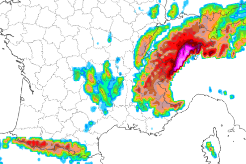
The origin of this extreme snowfall is in a mass of polar maritime air that will follow an active cold front, which is expected to hit the western Alps later tonight. This front is currently anchored by an area of low pressure to the north but will spawn a secondary low in the northern Mediterranean as the cold air interacts with the warm sea.
Anchored by lows both to the north and the south, the cold front will stall over the central-western Alps as it draws in lots of energy off the Mediterranean.
Areas most likely to see extreme snowfall from this storm are the eastern Aosta (e.g. Gressoney), the northern Piemonte (e.g. Alagna, Macugnaga) and the border regions of the Haut-Valais above Zermatt, Saas-Fee and the Simplon region. These regions are likely to see 1m or more snow (with some models predicting up to 1.5m) above 2000m in just 36 hours between Friday night and Sunday morning.
Elsewhere in the western Alps, most French, Swiss and western Italian resorts should see 20-60cm above 1600m or so, with the snow falling to very low levels (400-500m) for a time in the north-west on Saturday morning.
The central Italian Alps (e.g. Livigno) should also see a decent snowfall, though there will generally be a bit less in the Dolomites, and less still (or virtually nothing) in parts of northern and eastern Austria...