

Updated: 7.35am Monday 31 October 2016 - Winter within sight?
High pressure is still dominating the weather in the Alps, as we start the new week, with lots of sunshine and mild afternoon temperatures, especially at altitude. However, a cold front will introduce cooler weather (and a little snow for some) mid-week, with a more pronounced wintry blast likely next weekend.
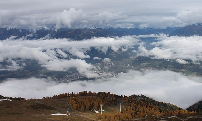
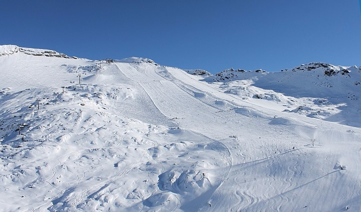
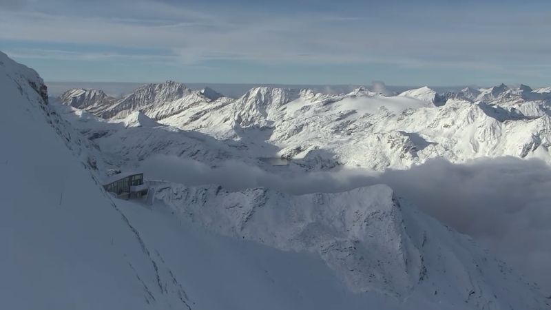
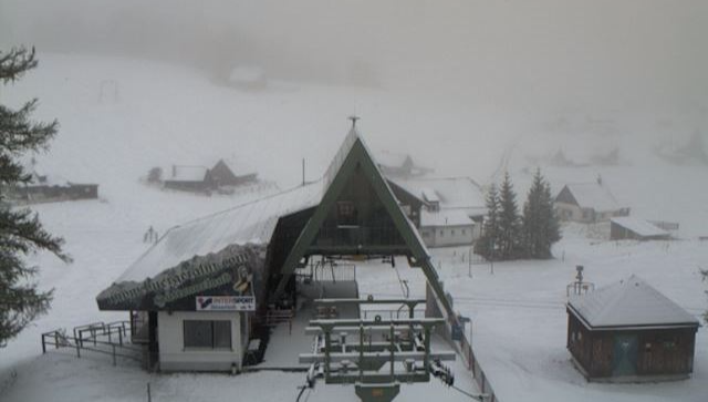
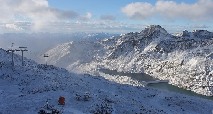
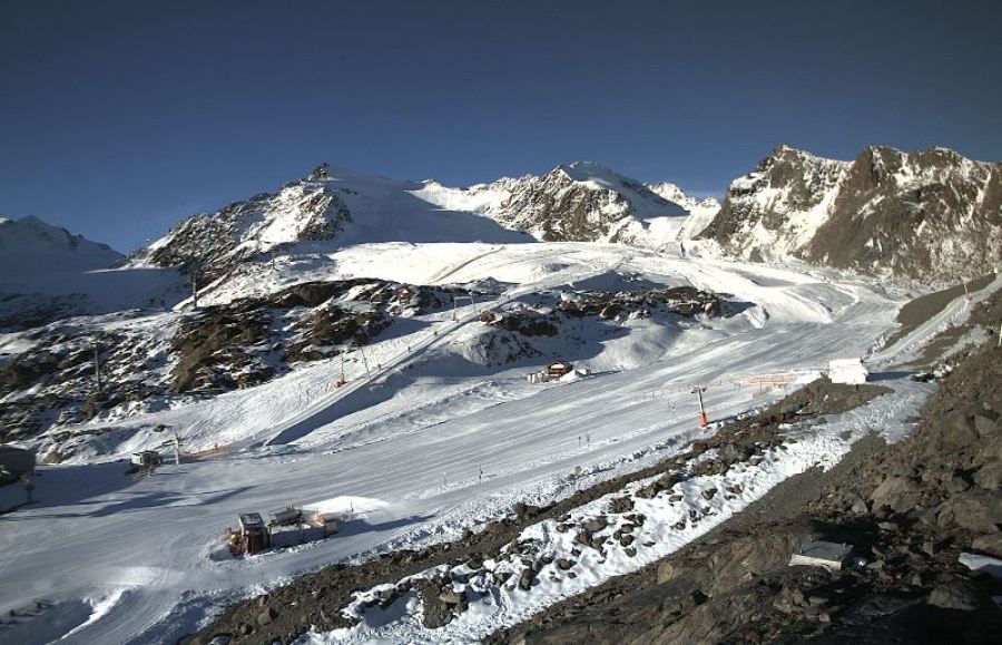 Another sunny day in prospect for the Alps – at least at altitude. This is the Pitztal glacier in the Austrian Tirol - 31 October 2016 - Photo: pitztaler-gletscher.at
The mid-week snow will very modest and mostly confined to the north-eastern Alps (e.g. Tirol, Salzburgland, Upper Austria). The western and southern Alps should remain dry and mostly sunny all week, though it will feel cooler from Wednesday onwards.
It is next weekend when things get really interesting, as an area of low pressure over the UK slides towards the Alps. It’s too far off to nail down any detail as yet, but there is a high chance of some heavier and more widespread snow for the Alps. Some models are even suggesting a succession winter storms moving in from the north-west next week but, again, we need a little more time before this can be properly verified.
In the meantime, the current fine weather means there is some very enjoyable skiing to be had on the glaciers (and in one or two non-glacial resorts).
In Austria you can ski on the glaciers at Hintertux, Stubai, Kaprun, Sölden, Mölltal, Pitztal, Kaunertal and Dachstein. Of these, the first four offer the greatest extent and variety. You can also ski in the Resterhöhe area of Kitzbühel on a strip of “managed” snow preserved over the summer.
In Switzerland you can ski on the glaciers at Zermatt, Saas-Fee, Glacier 3000, Engelberg and Diavolezza. Zermatt and Saas-Fee offer by far the greatest variety and extent of terrain.
In Italy you can ski on the glaciers at Val Senales, Passo Stelvio and Cervinia. A handful of non-glacial runs are also open at Solda (Sulden).
In France you can ski on the glaciers above Tignes and Les 2 Alpes, though the latter is only open until tomorrow, after which it will be closed until December.
Updated: 9.25am Saturday 29 October 2016 - Fine weekend for most
A huge area of high pressure centred to the north-west of the Alps will influence the weather over the weekend. Some areas of cloud will affect the eastern Alps today, especially this morning, but for the majority of regions it will be a mild and mostly sunny day.
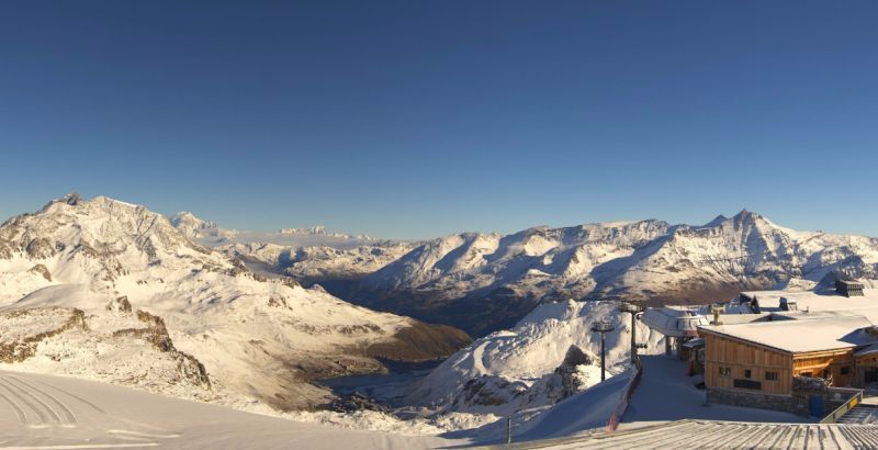
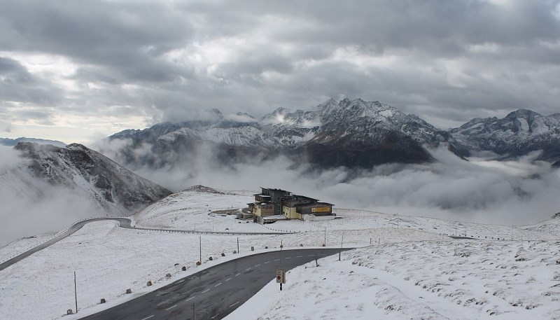
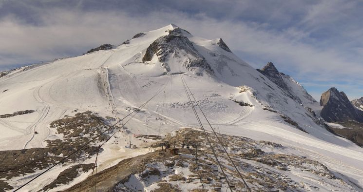
 Lots of sunshine expected in the western Alps today. This is the Grande Motte glacier above Tignes - 29 October 2016 - Photo: tignes.net
After a mostly fine start to next week, it will turn colder and more unsettled mid-week, with a little snow likely for some north-eastern parts of the Alps. However, this wintry blast will probably not be as significant as once hoped.
The medium term weather prospects are, however, very interesting and point towards a colder pattern with the chance of wider and more significant snow next weekend or the week after. We should stress that there is still lots of uncertainty over this at this point, but that the current signs are good.
In the meantime, you can currently ski in approximately 20 different places in the Alps.
In Austria these include all the glaciers - Hintertux, Stubai, Kaprun, Sölden, Mölltal, Pitztal, Kaunertal and Dachstein. Of these, the first four offer the greatest extent and variety. You can also ski in the Resterhöhe area of Kitzbühel on a strip of “managed” snow preserved over the summer.
 Skiing on “old snow” in Kitzbühel - 29 October 2016 - Photo: kitzski.at
In Switzerland you can ski on the glaciers at Zermatt, Saas-Fee, Glacier 3000, Engelberg and Diavolezza. Zermatt and Saas-Fee offer by far the greatest variety and extent of terrain.
In Italy you can ski on the glaciers at Val Senales, Passo Stelvio and Cervinia. A handful of non-glacial runs are also open at Solda (Sulden).
In France you can ski on the glaciers above Tignes and Les 2 Alpes, though the latter is open for half term only, and after this weekend remains closed until December.
Snow conditions are still generally good for October, though not quite as good as they were a week or two ago when there was more in the way of fresh snow. A little fresh snow is forecast mid-week, particularly for the eastern glaciers, with a chance of a more convincing return to winter in about 8-10 days time. Watch this space…
Updated: 1.30pm Friday 28 October 2016 - Lovely weekend for most
A huge area of high pressure centred over northern France is currently influencing the weather in the Alps, and will continue to do so over the weekend. Some low cloud/fog may plague the lowlands at times but, generally speaking, there will be a lot of sunshine in the Alps over the next few days. It will also feel very mild, especially at altitude.
 It’s a lovely autumn day in the Austrian Alps. This is near Kaprun – 28 October 2016 - Photo: foto-webcam.eu
Snow conditions on the glaciers are not as good as they were a week or so ago thanks to mild temperatures this week, as well as a mix of rain and wet snow. However, given the fine weather, there will be some very pleasant piste skiing to be had this weekend.
In Austria, all eight glacier areas are open with the most extensive slopes being found at Hintertux, Sölden, Stubai and Kaprun. Non-glacier skiing is also possible in Kitzbühel on a strip of snow that has been specially preserved over the summer!
In Italy you can ski on the glaciers at Val Senales, Passo Stelvio and (as of this weekend) Cervinia. Solda/Sulden is a fourth (non-glacial) option.
In Switzerland you can ski on the glaciers of Zermatt, Saas-Fee, Engelberg, Diavolezza and (as of tomorrow) Glacier 3000. Zermatt and Saas-Fee offer by far the most extensive slopes, however.
In France you can ski on the glaciers above Tignes and Les 2 Alpes, the latter open for this half term only.
The weather in the Alps looks quite interesting next week with a cold and potentially snowy northerly blast likely mid-week. Details may change but right now the north-eastern Alps are likely to do best (e.g. Vorarlberg, Tirol, Salzburgland, upper Austria). Watch this space…
Updated: 7.50am Thursday 27 October 2016 - Better weather today
The last 48 hours has seen plenty of rain around, especially (but not exclusively) in the northern half of the Alps. However, the weather has now improved, with plenty of sunshine in prospect, both to end the week and over the weekend.
 Plenty of sunshine across the Alps today, at least at altitude. This is the Tux valley in Austria - 27 October 2016 - Photo: foto-webcam.eu
The recent mild, and at times rainy, weather has melted a lot of the low-lying snow that fell in some parts of the Alps earlier in the month. Furthermore, it will continue mild over the next few days, with lots of sunshine at altitude. Looking a bit further ahead and it will start to cool down again later next week, but it is still too early to be speculating about when we will see the next significant snow.
In France, Les 2 Alpes opened last Saturday for half term only. You can also ski on the Grande Motte glacier above Tignes, though weather conditions have been highly variable this week. They will be much better this weekend.
In Switzerland the most extensive options are Zermatt and Saas-Fee but it is also possible to ski in Engelberg and on the Diavolezza glacier near St Moritz. Glacier 3000 will join them this weekend. Again, weather conditions have been highly variable this week but will be much better by the weekend.
In Italy you can ski in Val Senales, Passo Stelvio and (as of last weekend) Cervinia and Solda/Sulden. Cervinia, however, was only open at the weekend, reopening permanently on 29 October. The rest of the week and weekend will be mostly fine.
In Austria, all eight glacier areas are open, the best of which right now are probably Hintertux, Stubai and Kaprun. You can also ski in Kitzbühel’s Resterhöhe area which opened for the season on Saturday, made possible by re-laying old snow that had been preserved over the summer on the pistes. Expect mostly fine weather for the rest of the week and weekend.
Updated: 11.30am Wednesday 26 October 2016 - Still mild and changeable
The weather in the Alps remains mild and unsettled with further rain or showers in places, especially in the north. The best of any brightness will be in the south. This follows a very wet day for some yesterday, especially in the north-western Alps where the rain/snow limit was somewhere close to 3000m.
 Still a lot of cloud across the Alps today. This is Kronplatz – 26 October 2016 – Photo: kronplatz.com
Today the snow-line will be a little lower, between 2300m and 2800m in the western Alps, and 1700-2300m in the eastern Alps. Later in the day any showers will gradually ease but it will stay rather damp in the northern Alps.
Tomorrow will see a general improvement in the weather and by the weekend all the Alps should be enjoying plenty of sunshine and some very mild afternoon temperatures, particularly at altitude.
With all this milder weather, a lot of the low-lying snow that we saw last week has now melted. However, conditions on the glaciers are still ok. Granted, the weather in the Alps has been pretty miserable at times this week, but with sunnier skies forecast this weekend there should be some pleasant skiing on offer.
In France, Les 2 Alpes opened last Saturday (for half term only). You can also ski on the Grande Motte glacier above Tignes though weather conditions have been highly variable this week. They will be much better this weekend.
In Switzerland the most extensive options are Zermatt and Saas-Fee but, it is also possible to ski in Engelberg and on the Diavolezza glacier near St Moritz. Glacier 3000 will join them this weekend. Again, weather conditions have been highly variable this week but will be much better by the weekend.
In Italy you can ski in Val Senales, Passo Stelvio and (as of last weekend) Cervinia and Solda/Sulden. Cervinia, however, was only open at the weekend, reopening permanently on 29 October. The current mixed weather will be replaced by sunnier skies later this week, which will continue this weekend.
In Austria, all eight glacier areas are open, the best of which right now are probably Hintertux, Stubai and Kaprun. You can also ski in Kitzbühel’s Resterhöhe area which opened for the season on Saturday, made possible by re-laying old snow that had been preserved over the summer on the pistes. Expect glorious weather to prevail by the end of the week and over the coming weekend.
Updated: 10.55am Tuesday 25 October 2016 - Mild & showery
The weather in the Alps continues to come in from the south-west. Showers will be more widespread today than yesterday, especially in the west, with any snow confined to high altitudes.
 Generally cloudy skies in the Alps. Here is a little early brightness in Sulden in the Südtirol - 25 October 2016 - Photo: ortlerskiarena.com
The heaviest rain will be in the French and western Swiss Alps with snow only above 2800-3000m, while the driest brightest weather will be in the far south-eastern Alps, but general speaking there will be a lot of cloud around today.
Tomorrow the bulk of the showers will be further east, especially in Austria, with a snow-line descending to between 1600m and 2000m.
Anyone following weathertoski in recent days will know that snow conditions on the glaciers have generally been pretty good for October. This is still the case in theory, though mixed weather and poor visibility will make things trickier at times over the next 36 hours. Later in the week, however, the weather will have settled down again with some excellent skiing conditions in prospect this weekend.
In France, Les 2 Alpes opened on Saturday (for half term only). You can also ski on the Grande Motte glacier above Tignes, though both glaciers were shrouded in thick cloud this morning.
In Switzerland the most extensive options are Zermatt and Saas-Fee but, as of Saturday, it is also possible to ski in Engelberg and on the Diavolezza glacier near St Moritz. As in France, the weather may well be a problem today, but it will improve later in the week.
In Italy you can ski in Val Senales, Passo Stelvio and (as of last weekend) Cervinia and Solda/Sulden. Cervinia, however, is only open at the weekend, reopening permanently on 29 October. Again, the weather is poor today but will improve significantly later in the week.
In Austria, all eight glacier areas are open, the best of which right now are probably Hintertux, Stubai and Kaprun. You can also ski in Kitzbühel’s Resterhöhe area which opened for the season on Saturday, made possible by re-laying old snow that had been preserved over the summer on the pistes. Expect very mixed weather conditions over the next two days before sunnier skies return to all regions by Thursday.
Updated: 10.10am Monday 24 October 2016 - Mostly dry, variable cloud
The Alps remain under the influence of a south-westerly airflow which means lots of cloud (and a few showers) on the southern side of the Alps. On the north side, however, the Foehn is blowing, allowing brighter and warmer (but windy) conditions to prevail.
 Mostly cloudy on the southern side of the Alps. This is Plan Maison above Cervinia – 24 October 2016 – Photo: cervinia.it
If you are looking for new snow this week, there is going to some, but not a great deal. Today, a dusting of high altitude snow is possible close to the main Alpine ridge between Switzerland and Italy but no more than that. Then, on Tuesday and Wednesday, a weak cold front will slowly cross the Alps from west to east with a little snow here and there - first at high altitude, then to lower levels - but really not amounting to a great deal.
Later in the week the weather in the Alps will settle down again, with lots of sunshine likely next weekend.
Anyone who has been following the snow situation in the Alps will know that conditions on the glaciers have been pretty good in recent days, even exceptional at times in the eastern Alps, at least during breaks in the weather.
 Bright but “Foehny” on the north side of the Alps. This is Hochkönig in Austria – 24 October 2016 – Photo: hochkoenig.at
In France, Les 2 Alpes opened on Saturday (for half term only). In theory snow conditions are pretty good but the weather has been very mixed so far. You can also ski on the Grande Motte glacier above Tignes, where the weather is also changeable right now.
In Switzerland the most extensive options are Zermatt and Saas-Fee but, as of Saturday, it is also possible to ski in Engelberg and on the Diavolezza glacier near St Moritz.
In Italy you can ski in Val Senales, Passo Stelvio and (as of last weekend) Cervinia and Solda/Sulden. Cervinia, however, is only open at weekends, reopening permanently on 29 October.
In Austria, all eight glacier areas are open, the best of which right now are probably Hintertux, Stubai and Kaprun. You can also ski in Kitzbühel’s Resterhöhe area, which opened for the season on Saturday, made possible by re-laying old snow that had been preserved over the summer on the pistes.
As mentioned earlier the weather in the Alps is a still mixed, with the best of any brightness in the Austrian ski areas today. However, by the end of the week and over the weekend it should be sunny across the board.
Updated: 10.30am Sunday 23 October 2016 - Mixed
The weather in the Alps is now coming from the south-west. This means showers for the southern and western Alps but, protected by the Foehn, mostly dry, mild and windy conditions further north and east.
 Fair weather for most of Austria today. This Bad Kleinkirchheim - 23 October 2016 - Photo: badkleinkirchheim.at
Most of today’s showers will be in the southern French, central and western Italian Alps, as well as the far south of Switzerland, however some will get also through to the northern French and northern and western Swiss Alps. The rain/snow limit will be very variable, as low as 1300m in some western Italian regions (such as the upper Aosta valley) but 2400m or higher in the more exposed parts of the French Alps. Whatever, the case, snowfall totals will not be very significant, just a few cm at altitude here and there.
Thanks to the Foehn, the best of any sunshine today will be in the north-eastern half the Alps, especially in the northern Austrian Alps. However, mild temperatures will accelerate the thaw of any low-lying snow.
 Snowing this morning in Sestriere - 23 October 2016 - Photo: vialattea.it
In France, Les 2 Alpes opened yesterday (for half term only). In theory snow conditions are pretty good but the weather is miserable today with low visibility and snow showers. You can also ski on the Grande Motte glacier above Tignes where, despite it also being cloudy, the visibility was slightly better early this morning.
In Switzerland you can ski in Zermatt, Saas-Fee, and (as of yesterday) Engelberg and Diavolezza (near St Moritz). Zermatt and Saas-Fee have by far the most extensive terrain but, this morning at least, Engelberg and Diavolezza have the slightly better weather.
In Italy you can ski in Val Senales, Passo Stelvio and (as of this weekend) Cervinia and Solda/Sulden. Cervinia, however, is only open at the weekend, reopening permanently on 29 October.
In Austria, all eight glacier areas are open, the best of which right now are probably Hintertux, Stubai and Kaprun. You can also ski (on a carefully managed strip of snow) in Kitzbühel’s Resterhöhe area which opened for the season on Saturday. Overall, these Austrian ski areas definitely have the best of the weather today.
The weather for the rest of the week looks set to remain changeable with bits and pieces of snow here and there (at altitude) but no major new dumps on the horizon. There will also be some drier sunnier interludes at times.
Updated: 10.15am Friday 21 October 2016 - Lots of good skiing on the Alpine glaciers
The weather in the Alps will be mostly dry today, with a couple of exceptions. In the extreme south-east of Austria there are still a few residual showers from the recent storm (snow 1300m). Some showers (snow 1100-1300m) are also affecting the north-eastern Swiss and north-western Austrian Alps (e.g. Lech) though any accumulations of snow will be modest.
 Perfect snow conditions on the Mölltal glacier this morning - 21 October 2016 - Photo: gletscher.co.at
For much of the rest of the Alps it will be dry with variable cloud but generally plenty of sun, especially in the central and south-western Alps.
After a mostly fine day on Saturday, cloud and some showers will return to the south-western Alps on Sunday. However, with rising temperatures, any snow will be confined to relatively high altitude. The Foehn will also kick in in the northern Alps, lasting into the first part of next week, which means a rapid melting of any low-lying snow here, especially in northern Austria.
Snow conditions on the glaciers of the Austrian Alps are excellent, especially where there has been significant fresh snow in recent days. Best of all are Mölltal, Dachstein, Hintertux and Kaprun, all of which are in mint shape for October. The further west you go, the less fresh snow there has been, though generally speaking there is still some very enjoyable skiing to be had.
 A wintry looking picture in Carinthia. This is Falkert Heidialm Bergresort – 21 October 2016 – Photo: heidialm.at
In Austria, all eight glacier ski areas are open with the best snow conditions in the resorts above. This weekend will also see the first (as far as we know) entirely non-glacial resort in Austria to open some pistes – on the Resterhöhe sector in Kitzbühel.
In Switzerland you can ski in Zermatt and Saas-Fee, with Engelberg due to join them this weekend. These resorts have only seen a dusting of new snow in recent days but should still be able to offer some perfectly decent skiing, with the most extensive terrain in Zermatt and Saas-Fee.
In Italy you can ski on the glaciers at Val Senales and Passo Stelvio, with Cervinia joining the action this weekend (weekend only) and on a more permanent basis from 29 October on. Of these resorts, Passo Stelvio is probably in the best condition, though Cervinia will offer the most terrain – at least if the links to Zermatt are open over the weekend. We understand that Solda in the Südtirol will also open tomorrow.
In France you can ski on the Grande Motte glacier above Tignes and, as of this weekend, in Les 2 Alpes which will open for half term only. Both glaciers have missed the heaviest of the recent snow but are still in good condition for October.
Updated: 10.15am Thursday 20 October 2016 - Heavy snow in parts of the eastern Alps
As forecast, some eastern and south-eastern parts of the Alps have woken up to a significant fall of snow - 30cm+ above 2000m in places - with more to come this morning.
 Heavy snow in Carinthia this morning. This is Emberger Alm - 20 October 2016 - Photo: embergeralm.at
The heaviest snow has been in the eastern Austrian Alps, especially in the south-eastern Salzburgland, Styria and Carinthia. Parts of the Dolomites have also seen a moderate fall of snow but, except for the odd dusting, most other parts of the Alps have missed out on this occasion.
The snow-line started above 1700-2000m yesterday but fell steadily to reach 900-1400m overnight and first thing this morning. Today it will continue to snow for a while in the south-eastern Alps (especially Carinthia and the extreme north-eastern Dolomites) before gradually dying away later.
Elsewhere in the Alps, cloud cover is variable with the best of any sunshine at altitude and in the west/south-west. Most places will be dry but one or two showers (snow 1200-1400m) cannot be ruled out close to the northern foothills of the Alps later.
 Lots of new snow today near Heiligenblut in Carinthia – 20 October 2016 – Photo: heiligenblut.at
On Friday, the southern half of the Alps will see the best of the weather while the northern Alps catch a few showers (snow 1000-1400m), these heaviest in the northern Swiss and north-western Austrian Alps.
Over the weekend the airflow will gradually switch to a more southerly direction. This means that it will turn milder, but also unsettled in the south-western Alps (southern French and western Italian Alps) with showers and a little high altitude snow.
 Snow to resort level in Obertauern (Salzburgland) this morning – 20 October 2016 – Photo: obertauern.at
Snow conditions on the glaciers remain generally good for October. The areas with the most fresh snow are Mölltal, Hintertux, Kaprun and Dachstein, all of which should be skiing superbly this weekend. The further west you go, the less new snow there has been in recent days. Nevertheless the likes of Zermatt, Saas-Fee and Tignes can still all provide very enjoyable piste skiing.
For a full round up of what is open and what is opening this weekend, tune in to weathertoski tomorrow morning…
Updated: 9.50am Wednesday 19 October 2016 - Significant snow for some eastern parts of the Alps
An area of low pressure and its associated fronts are drifting slowly towards the Alps from the north, meanwhile a new low is forming in the Mediterranean. Over the next 36 hours or so the interaction of these lows is likely to deliver significant snow to some eastern and south-eastern parts of the Alps.
 Most of the snow over the next couple of days will be in Austria, especially the south-eastern Austrian Alps - 19 October 2016 - Image: bergfex.at
This morning there are already plenty of showers across Austria, especially to the east of Innsbruck, with a rain/snow limit sinking to between 1200-1500m later in the day. These showers will tend to intensify as the day goes on, especially in the eastern and southern Austrian Alps (e.g. Obertauern, Nassfeld), also developing across the border in the Dolomites (e.g. Cortina).
Except for a few showers across the far north, most other parts of the Alps will be dry today with variable cloud and the best of any sunshine in the south-west.
Tomorrow will see further snow (1000/1400m) in the eastern and south-eastern Austrian Alps (especially close to the Austrian/Slovenian border). Elsewhere, except for a few scattered light showers (mostly in the north) it will be dry with variable cloud and sunny periods. It will, however, feel cold for the time of year.
 The best of today’s sunshine will be in the western Alps. This is Gressoney – 19 October 2016 – Photo: monterosa-ski.com
Over the next 36 hours we can expect 20-40cm of new snow above 1800m in some eastern parts of the Alps, especially the eastern and southern Austrian Alps (e.g. Obertauern, Bad Kleinkirchheim, Nassfeld) but also perhaps the far northern and eastern Dolomites.
Of the glaciers open right now, those that will benefit the most from the next storm will be the Dachstein, the Kitzsteinhorn (Kaprun), Hintertux and Mölltal. Snow conditions on the glaciers are generally pretty good for October and will of course improve further in Austria over the next day or two.
In France you can ski on the Grande Motte glacier above Tignes, with Les 2 Alpes joining the action (half term only) this weekend. Both resorts saw a moderate dump of snow last Friday so snow conditions should be pretty good.
In Italy, you can ski on the glaciers at Val Senales and Passo Stelvio, with Cervinia opening this weekend (weekend only) then permanently the weekend after. All three glacier areas have seen significant snow in recent days so skiing conditions should be good.
In Switzerland, you can ski in Zermatt and Saas-Fee (both of which saw significant new snow last Friday) with the Diavolezza glacier set to join them this weekend. Engelberg is set to make a decision today on whether it will open this weekend (22 October). Glacier 3000 near Les Diablerets will open on 29 October.
All eight Austrian glaciers are open and in good condition, with the best skiing probably in Hintertux and Kaprun. The other open areas are Mölltal, Pitztal, Kaunertal, Sölden, Stubai and Dachstein.
Updated: 10.10am Tuesday 18 October 2016 - Remaining changeable and turning colder
The weather in the Alps looks set to remain unsettled for the rest of the week. With the air being drawn in increasingly from the north, it will also turn colder with significant snow possible to below 1000m in some of the eastern Alps by late Thursday.
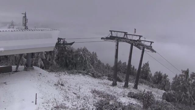
 Cloudy with occasional light snowfall expected on the Pitztal glacier today - 18 October 2016 - Photo: pitztal.at
Looking back at yesterday, and we saw some light snow in the western Alps (mostly the northern French and western Swiss Alps) but only above 2300m or so. Today these showers have spread further east to affect many northern parts of the Alps including Austria. They will remain mostly light in nature, but a few cm of new snow are possible above 1800-2200m. The southern half of the Alps will have the best of any sunshine.
Temperatures will continue to fall for the rest of the week with further showers in places, these heaviest in the eastern Alps with some significant snow possible in the southern and eastern Austrian Alps as well as the Dolomites later on Thursday. Watch this space…
 Further light snowfalls on the Stubai glacier today - 18 October 2016 - Photo: stubai-gletscher.com
In the meantime, snow conditions on the glaciers are pretty good for October, even if the weather will be less than ideal over the next few days. In France, you can ski on the Grande Motte glacier above Tignes, with Les 2 Alpes joining the action (half term only) this weekend. Both resorts have seen fresh snow in recent days so snow conditions should be good.
In Italy you can ski on the glaciers at Val Senales and Passo Stelvio, with Cervinia opening this weekend, at the weekend only, then permanently from the weekend after. All three glacier areas have seen significant snow in recent days so skiing conditions should be good.
 The best weather is on the southern side of the Alps today. This is Sestriere - Photo: vialattea.it
In Switzerland you can ski in Zermatt and Saas-Fee, both of which saw significant new snow on Friday, with the Diavolezza glacier set to join them this weekend. Engelberg is set to make a decision tomorrow as to whether it will open this weekend (22 October). Glacier 3000 near Les Diablerets will open on 29 October.
All eight Austrian glaciers are open and in pretty good condition, with the best skiing probably in Hintertux and Kaprun. The other areas are Mölltal, Pitztal, Kaunertal, Sölden, Stubai and Dachstein.
Updated: 11.05am Monday 17 October 2016 - Unsettled week ahead
After a largely fine day yesterday, the weather in the Alps is turning more unsettled again, this time from the north-west. In fact, every day this week we can expect at least a little snow at altitude somewhere in the Alps.
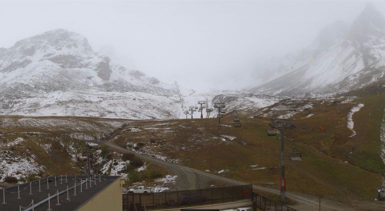 Looking up towards the glacier in Tignes, where further light snow is falling today – 17 October 2016 – Photo: tignes.net
Today, it is the northern French and western Swiss Alps that will see most of any snow, though it won’t amount to very much – just a few cm here and there above 2400m or so. Further east it will be mostly dry, though still rather cloudy.
On Tuesday, showers will extend further east to affect other northern parts of the Alps (snow 2100m) though snowfall totals will again be negligible. On Wednesday and Thursday there is the chance of some more significant snow in the eastern Alps, but the situation is complicated and the detail is likely to change.
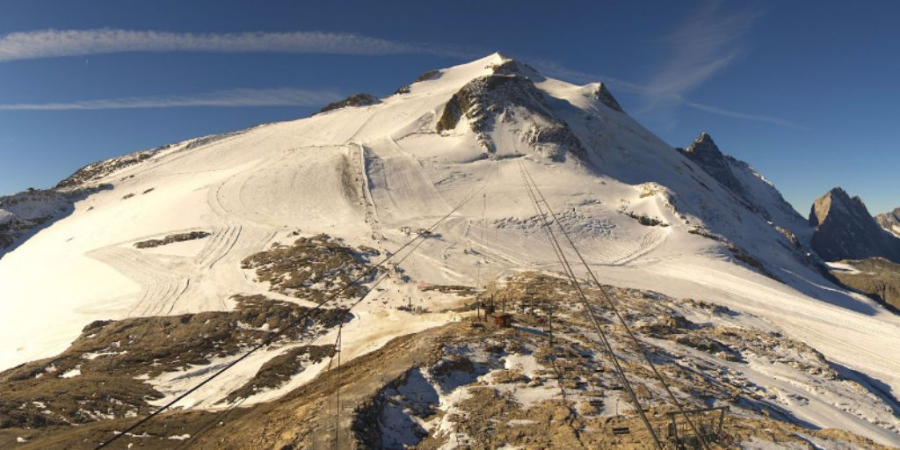
 Good snow cover on the glacier at Passo Stelvio - 17 October 2016 - Photo: passostelvio.com
In the meantime, most of the Alpine glaciers are skiing very well for October thanks to recent snowfall. All the Austrian glacier areas are now open - Hintertux, Stubai, Kitzsteinhorn Mölltal, Sölden, Kaunertal, Pitztal and Dachstein. These Austrian glaciers missed the heaviest of the snow on Friday/Saturday, but all did well from other storms early last week.
In Switzerland, you can ski in Zermatt and Saas-Fee, both of which received large quantities of snow on Friday. In Italy, you can ski at Passo Stelvio and Val Senales, with Cervinia joining them this weekend (weekend only). These Italian resorts, especially Cervinia, also saw significant snowfall last Friday. In France, you can ski in Tignes, and Les 2 Alpes opens (for half term only) this weekend. Again, both resorts did well from last Friday’s storm, especially Les 2 Alpes.
Updated: 9.15am Sunday 16 October 2016 - Return of the sun
The weather in the Alps has settled down, with plenty of sunshine on offer across all regions today. The best skiing conditions are on the glaciers of the western Alps (Tignes, Zermatt and Saas-Fee), which saw the heaviest snow on Friday.
 Beautiful day in the Austrian Alps. This is the Mölltal glacier - 16 October 2016 - Photo: gletscher.co.at
Further east, Val Senales and Passo Stelvio (both in Italy) also saw significant snow, but Austria missed most of the action this time round. Still, they had the lion’s share earlier in the week so conditions are ok, if a little wind-scoured in places.
The coming week will see further snow in places, especially at mid-week in the north-east. Stay tuned for details…
As for where it is currently possible to ski in the Alps:
- Austria - all the glaciers are now open for skiing (including the Dachstein). In Switzerland you can ski in Zermatt and Saas-Fee.
- Italy - the only two options remain Passo Stelvio and Val Senales, though Cervinia will join them next weekend (weekends only).
- France - Tignes will be joined by Les 2 Alpes (for half term only) next weekend.
Updated: 9.20am Saturday 15 October 2016 - Powder day for the western glaciers!
Snow conditions are exceptional today in the western Alps, with sunny skies and powdery pistes on the glaciers at Tignes, Zermatt and Saas-Fee. Indeed Saas-Fee has announced that skiing will be possible all the way down to the middle station at Morenia (2550m).
 Snow almost all the way down to Tignes this morning - 15 October 2016 - Photo: tignes.net
These excellent Autumn skiing conditions come thanks to the recent storm which dumped 40-80cm of new snow across some southern French and western Italian resorts, as well as the far south of Switzerland.
Other glaciers to have benefited from at least some new snow include Passo Stelvio and Val Senales, but the Austrian glaciers have largely missed out this time around, though they did have the lion’s share of snow last week.
 Fabulous snow conditions on the Grande Motte glacier above Tignes - 15 October 2016 - Photo: tignes.net
The recent storm saw snow falling as low as 1100-1400m for a time in the southern French and western Italian Alps (e.g. Sestriere, Courmayeur) before temperatures eventually rose later in the day yesterday.
 Picture perfect up-top in Saas-Fee today - 15 October 2016 - Photo: saas-fee.ch
However, thanks to the Foehn, temperatures rose much faster on the northern side of the Alps, which meant that any snow here was confined to between 2500m and 3200m by Friday afternoon.
Indeed we had a situation yesterday where it was still snowing to 1200m in Courmayeur on the Italian side of Mt Blanc, but only above 3000m in Chamonix on the northern side!
 Another view of the glacier at Saas-Fee, this time from below - 15 October 2016 - Photo: saas-fee.ch
Today a few showers will persist in the eastern Alps but, generally speaking, the weather is improving and Sunday is expected to be fine across the board.
After a settled start next week, a little snow is expected to return to the Alps mid-week, mostly in the north. Watch this space…
Updated: 11.40am Friday 14 October 2016 - Wild and mild!
As expected we saw quite a lot of snow in the southern French and western Italian Alps yesterday, with 40cm or more at altitude in the Haute-Alpes (e.g. Serre-Chevalier) and southern Piedmont (e.g. Sestriere). The rain/snow limit was also quite low in these regions, 1100-1400m, before it started to rise overnight.
 Lots of new snow in Sestriere, but today will be milder and increasingly rainy - 14 October 2016 - Photo: vialattea.it
There will be further heavy snow in the south-western Alps today but, with warmer air flooding in, it will be confined to increasingly high altitudes. The heaviest precipitation will be this afternoon and evening in the northern Piedmont (e.g. Alagna), eastern Aosta (e.g. Cervinia/Champoluc), and the far south of Switzerland (from Zermatt eastwards to the Bernina Pass). However, the rain/snow limit will reach 2500-3000m by evening. Above 3000m these regions can expect 50-90cm of new snow by tomorrow afternoon.
In the northern half of the Alps there is currently a violent Foehn. Some showers will get through to the northern French and western Swiss Alps (snow 3000m+) but many northern regions are dry, very mild and very windy.
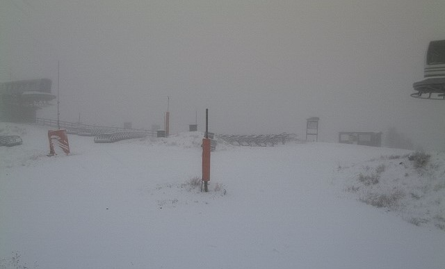
Whichever way you look at it, it is not a great day to be out and about in the high Alps, with most of the glacier areas either likely to be closed or partially closed due to adverse weather conditions.
 Protected by the Foehn, the northern and especially north-eastern Alps will be mostly dry, if still rather cloudy. This is Laax - 14 October 2016 - Photo: Laax.com
Tomorrow, the Foehn will die down and the storm will attempt to move eastwards, but will die out as it does so. Some showers will extend further north and east (with a little snow above 2500-2700m) but sunnier skies will return to the western Alps.
After a relatively settled start to next week, the weather in the Alps will turn colder and more unsettled from the north or north-west mid-week, with further snow likely in places (particularly in the northern Alps).
Updated: 8am Thursday 13 October 2016 - Big change in the Alpine weather
It’s all change with the weather in the Alps today as active weather fronts move in from the south-west. In short, we can expect lots of precipitation in the south-western Alps over the next day or two but also a rising snow line. The greatest rise in temperature, however, will be reserved for the northern Alps, where a strong Foehn will kick in.
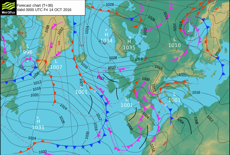 Weather fronts piling into the south-western Alps with a squeeze of isobars to the north (Foehn effect) - Image: metoffice.gov.uk
Today the bulk of the precipitation will be in the southern French, western Italian and extreme southern/south-western Swiss Alps where the rain/snow limit will start low (1100-1400m), especially on the Italian side, before slowly rising later.
The northern French Alps will also see some showers, but here they will be more scattered and the rain/snow limit will start higher (1800-2000m), and rise fast.
Except for a few showers in the central Italian Alps later today, most other Alpine regions will be dry, but with an increasingly strong Foehn wind in the northern half of the Alps.
Tomorrow, will see further heavy precipitation across the south-western Alps. Some sheltered valleys of the north-western Italian Alps (e.g. Aosta) may continue to see a relatively low rain/snow limit for a time but, generally speaking, freezing levels will be higher with the snowline more typically reaching 2300m to 2800m.
The northern Alps will continue mostly dry with a strong Foehn that will quickly melt any remaining low-lying snow. The storm will also struggle to make much progress eastwards, dying out in situ over the weekend.
 Snowing already in the western Italian Alps. This is Sestriere – 13 October 2016 - Photo: vialattea.it
So where will this leave the Alps in terms of snow conditions by the end of the weekend?
One thing is for sure, in terms of operating ski areas, the glaciers at Zermatt and Saas-Fee will see the most new snow - well over 50cm by most calculations. Tignes, Passo Stelvio and Val Senales will also see some fresh snow, though probably not as much. The Austrian glaciers, by contrast, will see little or no new snow from this storm, but they can hardly complain as they have had the lion’s share over the last week or so.
Another noticeable feature over the next few days will be the increase in temperature, especially across the Foehn-affected northern Alps, where any low lying snow will quickly disappear.
If you are planning to ski in the Alps over the next couple of days, expect plenty of disruption due to bad weather, especially wind. However, later this weekend and into the first part of next week the weather looks like being more settled. Stay tuned…
Updated: 8.10am Wednesday 12 October 2016 - Big storm approaching south-western Alps
The cold Siberian air that has been affecting the Alps over the last few days is on its way out as a major storm approaches from the south-west. This storm will bring significant snow at altitude to the southern French, western Italian and southern Swiss Alps later on Thursday and Friday, but also a rise in temperature.
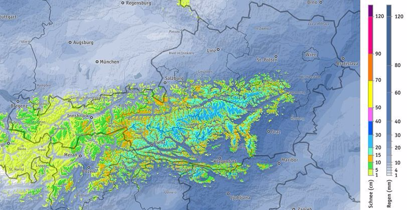
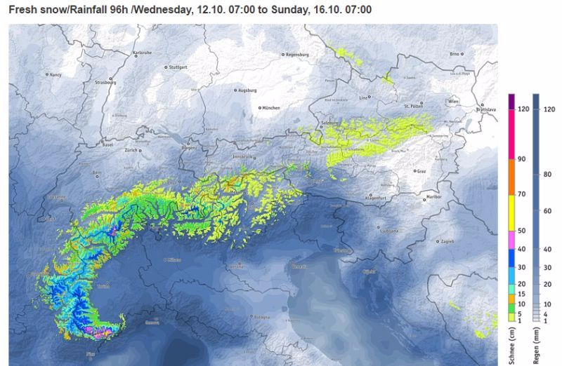 Predicted snowfall totals in the Alps between Wednesday and Sunday – Image: bergfex.com
In terms of open ski areas, the resorts that will see the most snow from this new storm are Zermatt and Saas-Fee, both of which could see 40-60cm up on their glaciers between Thursday and Saturday, perhaps even more. Tignes, Passo Stelvio and Val Senales will also see some snow, though not as much. However, most Austrian glaciers will miss out this time round. Still, they can’t really complain as they have had the lion’s share of snow over the last week or so.
Before this storm arrives we have a relatively benign weather day in store today, with sunny spells and just a few residual showers/flurries in the eastern Austrian Alps. Tomorrow, the storm’s rain/snow limit will start low, at around 1200-1500m in the southern Alps (especially in the western Italian Alps), rising later, especially on Friday (1800-2600m).
The rise in temperature will come earlier and more abruptly on the north side of the Alps due to a strong Foehn that will send freezing levels here close to 3000m by Friday, and quickly melt any low lying snow. Lift operations on many of the glaciers could well be affected by wind on Thursday and Friday, possibly also into the weekend. Stay tuned…
Updated: 10.15am Tuesday 11 October 2016 - Still cold with further snow in places
The weather in the Alps continues to arrive from the north-east which means below average temperatures and further snow in places.
 Snow to low levels in the eastern Austrian Alps. This is Planneralm in Styria - 11 October 2016 - Photo: planneralm.at
As regular followers of weathertoski will know, there have already been multiple snowfalls across many eastern (and some southern) part of the Alps over the last few days, which means that conditions on the Austrian glaciers - as well as Passo Stelvio and Val Senales in Italy - are particularly good right now (at least if you get a break in the weather).
Further west, there has been little or no recent snowfall in the likes of Tignes, Zermatt and Saas-Fee but, at least, skiers here have been enjoying plenty of sunshine.
 Fresh snow in Foppolo in Lombardy, though they won’t be opening for some weeks -11 October 2016 - Photo: foppolo.provinciabergamasca.com
Today we can expect a further scattering of snow showers across the southern and eastern Alps, which will become mostly confined to the eastern Austrian Alps tomorrow. Then on Thursday we are expecting a radical change in the weather as a major storm moves into the south-western Alps. This will bring heavy snow at altitude to the southern French and western Italian Alps in particular, but also a significant rise in temperature. Stay tuned!
In the meantime you can ski (weather permitting) on all the Austrian glaciers except the Dachstein, with the Kitzsteinhorn above Kaprun offering the best snow conditions. In Italy you ski on the glaciers at Passo Stelvio and Val Senales, both of which also have plenty of fresh snow.
In Switzerland, Saas-Fee and Zermatt are open but here there has been very little new snow over the last few days and the pistes are harder. It’s a similar story in France, where Tignes is the only lift-served option and there has been no new recent snow. However, these western glaciers are all expected to see significant new snow later this week.
Read our more detailed report on where to ski in the Alps in October.
Updated: 9.30am Monday 10 October 2016 - Yet more snow for the Alps!
Many eastern, and some southern, parts of the Alps have woken up to yet more snow this morning with parts of Lombardy (Italy) seeing as much as 30cm of new snow at altitude.
 Significant new snow in Lombardy this morning. This is Livigno - 10 October 2016 - Photo: valtline.it
It follows a week of below average temperatures with small but frequent snowfalls across the eastern Alps, especially in the central and eastern Austrian Alps where at altitude there are now some moderate accumulations of new snow (20-50cm).
In the last 24 hours, however, these snow showers have extended to some southern parts of the Alps, with Lombardy (e.g. Livigno) benefiting the most.
 Powder day on the Hintertux glacier - Photo: facebook.com/glacier.Hintertux
Temperatures will remain on the low side for the rest of the week with the chance of more snow in places, looking likely to be heaviest in the southern and south-western Alps on Thursday.
Snow conditions are therefore excellent in the eastern half of the Alps with all the Austrian glaciers, together with Passo Stelvio and Val Senales in Italy, benefiting from fresh snow.
 Early snowfall in Sulden in the Südtirol -10 October 2016 - Photo: seilbahnensulden.it
The western glaciers (such as Zermatt, Saas-Fee and Tignes) have missed the snow so far but are still in reasonable shape for early October.
Read our more detailed report on where to ski in the Alps in October.
Updated: 8.10am Sunday 9 October 2016 - Remaining wintry in the eastern Alps
Temperatures in the Alps remain below normal with further flurries in places, chiefly in the eastern Alps. The best of any sunshine will again be at altitude in the west. The rain/snow limit today will be between 1100m and 1500m, but any snowfall will again be modest.
 Plenty of snow at altitude in the northern and eastern Austrian Alps. This is the Kitzsteinhorn above Kaprun – 9 October 2016 – Photo: kitzsteinhorn.at
Individual snowfalls may have been modest this week, but in the north-eastern Alps in particular they have been repetitive, which means that some areas do have moderate accumulations (20-40cm) of new snow at high altitude.
In terms of skiable glaciers, the area to have so far benefited most from this new snow is the Kitzsteinhorn near Kaprun. However, all other Austrian glaciers have seen at least a little snow over the last few days.
Temperatures will remain on the cool side over the next few days with the chance of further snow in places, especially in the eastern and southern Alps. Watch this space…
Read our more detailed report on where to ski in the Alps in October.
Updated: 10.45am Saturday 8 October 2016 - Further flurries for the eastern glaciers
The Alps remain under the influence of a cool north-easterly airflow, with a scattering of showers/flurries for the eastern Alps and the best of any sunshine further west.
 Looking wintry on the way up to the Grossglockner pass near Heiligenblut - 8 October 2016 - Photo: foto-webcam.eu
Most of the showers will be across Austria, but some northern and eastern parts of the Swiss Alps may also be affected, as well as the central and eastern Italian Alps, especially later in the day.
The rain/snow limit will be low, between 1100m and 1500m, lowest in the far eastern Alps. However, quantities of snow are again expected to be modest with just a few cm at altitude here and there.
 Sunny at altitude in the western Alps, this is Tignes - 8 October 2016 - Photo: tignes.net
Snow conditions remain best in Austria where there has been a little fresh snow over recent days. The pistes are harder/more worn further west (e.g. Tignes), where there has been more in the way of sunshine this week.
Read our more detailed report on where to ski in the Alps in October.
Updated: 9.50am Friday 7 October 2016 - Still cool and unsettled in the east
The weather in the Alps continues to come from the north-east, with below average temperatures and a scattering of showers for the eastern Austrian Alps. The best of the sunshine remains further west, especially at altitude.
 Fresh snow to low levels in the eastern Austrian Alps. This is Hinterstoder - 7 October 2016 - Photo: hinterstoder.at
Any showers in the far eastern Alps will fall as snow above 1200-1500m today, but will not amount to much. Over the weekend, the chance of showers or flurries extends to other eastern as well as southern parts of the Alps, but they will remain mostly light and well scattered.
Snow conditions on the glaciers remain ok, best in Austria which has seen the lowest temperatures as well as most of the recent (light) snowfall. Temperatures look set to remain on the cool side next week with the chance of further snow for some. Watch this space...
Read our more detailed report on where to ski in the Alps in October.
Updated: 9.50am Thursday 6 October 2016 - Remaining chilly, especially in the east
The Alps remain under the influence of a cool north-easterly airflow with mostly sunny skies (at altitude at least) in the west, but more in the way of cloud with a few showers in the far east.
 Snow to low levels in the eastern Austrian Alps. This is Aflenzer Bürgeralm in Styria - 6 October 2016 - Photo: Aflenzer-buergeralm.at
Most of the showers will be confined to the north-eastern Austrian Alps with a rain/snow limit somewhere between 900m and 1300m. Significant accumulations of snow are not expected, but it will feel decidedly chilly if you are out and about in the mountains today, especially in Austria.
Temperatures are forecast to remain below average over the next few days with snow flurries perhaps becoming a little more widespread over the weekend and into next week, especially in the southern and eastern Alps. Watch this space…
 Pistes looking slightly worn again on the Grand Motte glacier above Tignes - 6 October 2016 - Photo: Tignes.net
Snow conditions on the glaciers are generally ok, and best in Austria where there has been a little fresh snow over recent days. Further west (e.g. Tignes) the pistes are looking slightly worn again but at least here the weather has been sunnier this week.
Read our more detailed report on where to ski in the Alps in October.
Updated: 9.55am Wednesday 5 October 2016 - Remaining cool with further flurries for the far eastern Alps
The Alps remain under the influence of a cool north-easterly airflow. Most places will be dry and fairly sunny (at altitude at least). By contrast, the eastern Austrian Alps will see more in the way of cloud with one or two snow flurries (1200m).
 Fresh snow on the mountains above Kaprun - 5 October 2016 - Photo: foto-webcam.eu
Temperatures will remain on the cool side for the rest of the week with further bits and pieces of snow possible in the eastern Alps. Over the weekend, an area of low pressure is likely to form over the Gulf of Genoa increasing the chance of snow showers in the southern Alps - watch this space…
The best snow conditions continue to be found on the Austrian glaciers, though you will have to put up with some variable weather this week. The pistes are harder further west (e.g. Zermatt, Tignes) but here at least the sun is more likely to be shining.
Read our more detailed report on where to ski in the Alps in October.
Updated: 9.40am Tuesday 4 October 2016 - Further snow for parts of the Austrian Alps
The Alps are under the influence of a cool north to north-easterly airflow this week, with occasional snow for some higher parts of the eastern Alps, but mostly sunny weather in the west, at least at altitude.
 Fresh snow on the Zugspitze close to the Austrian-German border – 4 October 2016 - Photo: zugspitze.de
Today, it will snow (on and off) in the northern and eastern Austrian Alps, especially to the north and east of Innsbruck, with a rain/snow limit somewhere between 1400m and 1900m. Most other parts of the Alps will be dry, with more and more sunshine the further west you travel.
The weather pattern will stay broadly similar for the rest of the week with mostly sunny skies in the western Alps (above any low cloud) and occasional showers in the east - especially in the eastern Austrian Alps where the snow line may briefly lower to 1000m mid-week.
 Sunny skies for the western Alps. This is Saas-Fee in Switzerland - 4 October 2016 - Photo: saas-fee.ch
In theory, the best snow conditions right now are in the Austrian glacier resorts (e.g. Hintertux, Kaprun). However, with highly variable weather conditions, you might argue that the more enjoyable skiing is to be found in the sunnier west (e.g. Zermatt, Saas-Fee, Tignes), even if there is less in the way of fresh snow.
Read our more detailed report on where to ski in the Alps in October.
Updated: 8.20am Monday 3 October 2016 - Fresh snow for the eastern Alps!
Welcome to “Today in the Alps”, our daily overview of weather and snow conditions in the Alps, where our build up to the 2016-17 winter season starts with some good news for the eastern glaciers…
 Fresh snow to 1800m or so in the Tux valley in Austria - 3 October 2016 - Photo: foto-webcam.eu
The Alps are under the influence of a cool and humid north/north-easterly airflow which has already brought a little snow to some higher parts of the Alps (especially the east) with further snowfalls likely in places this week.
Most of this snow will be in the northern and eastern Austrian Alps, where it could fall as low as 1000m for a time mid-week. Weather-permitting, the best snow conditions this week are therefore likely to be in the north-easternmost glaciers at Hintertux and Kaprun.
 Looking more wintry on the Mölltal glacier in the southern Austrian Alps - 3 October 2016 - Photo: gletscher.co.at
The more western glaciers (e.g. Zermatt, Saas-Fee, Tignes) will stay mostly dry this week, but here too there have been recent dustings of snow, and with temperatures set to stay relatively cool, on-piste skiing conditions should be reasonable.
Read our more detailed report on where to ski in the Alps in October.