

ARCHIVE
Today in the Alps - November 2016
Updated: 8.15am Wednesday 30 November 2016 - Very little new snow in the foreseeable future
High pressure will dominate the weather in the Alps this week, though a weakening cold front will brush the north-eastern Alps on Friday. We can therefore expect mostly dry and sunny weather over the next few days (at least above any stubborn low cloud or fog patches) with just a little snow in the extreme eastern Austrian Alps on Thursday night and Friday.
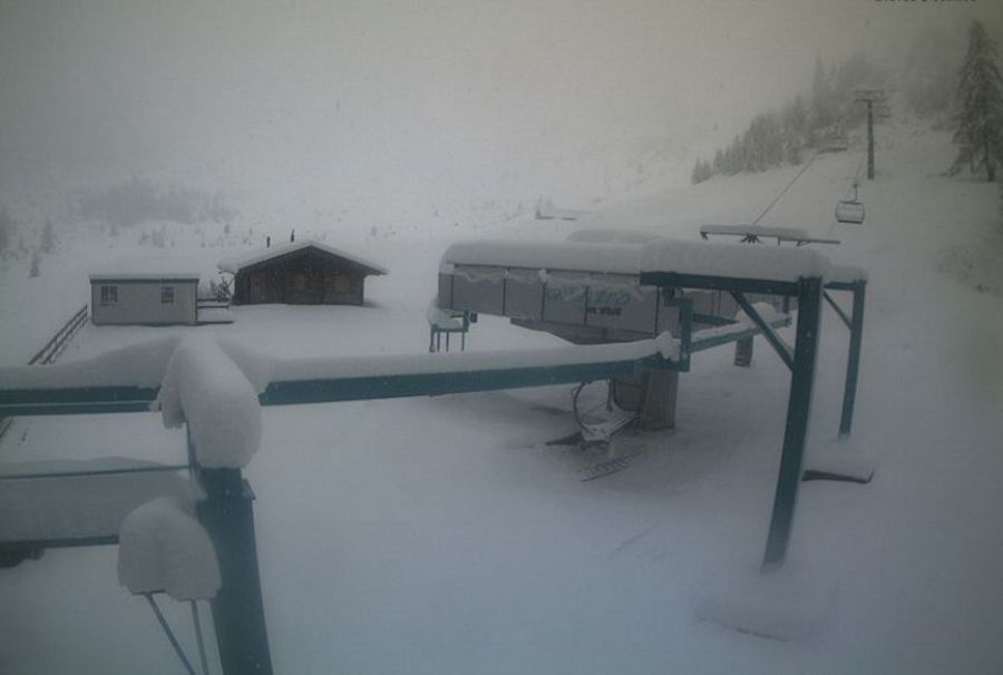
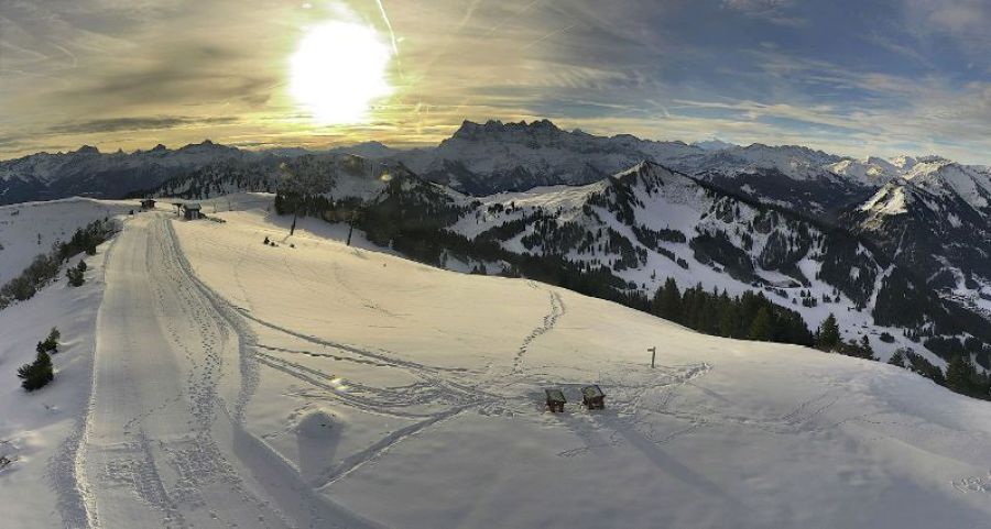
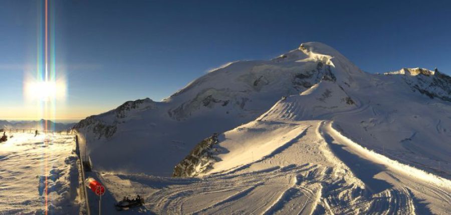
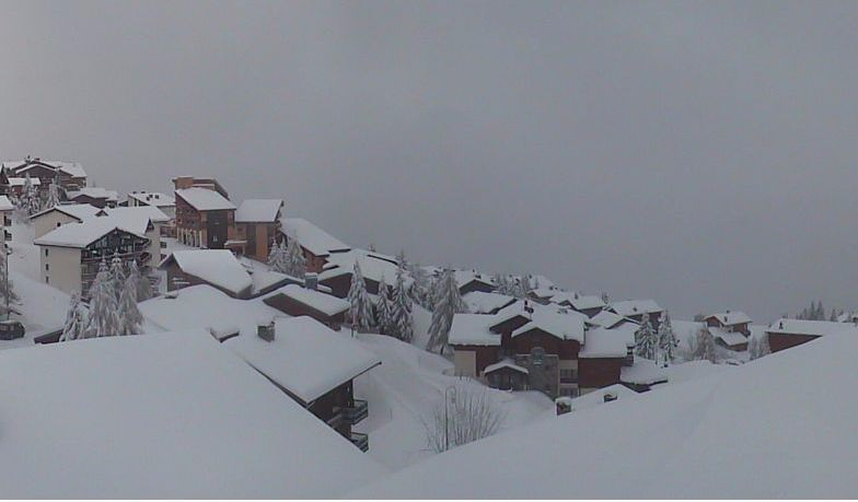
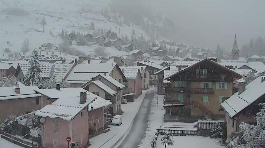
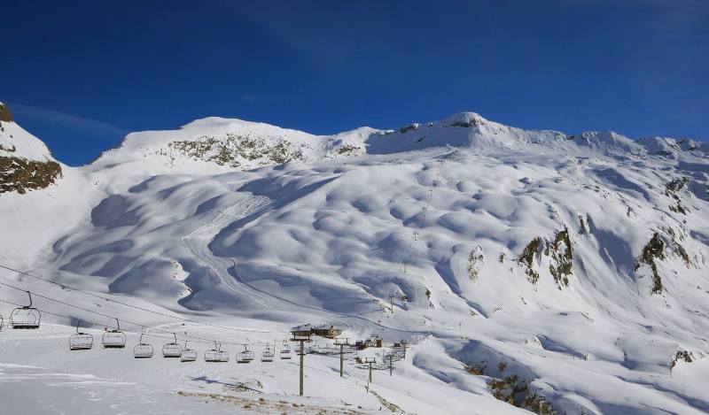 Fabulous snow conditions in Val d’Isère right now – 30 November 2016 – Photo: facebook.com/Radio-Tv-Val-Disere
It will feel mild this week in any sunshine, especially on south-facing slopes. By contrast, north-facing slopes and shady valleys could remain frosty for much of the day.
Snow conditions in the Alps remain very mixed, with generally very little useful snow below 1800m or so. By contrast, above 2000m snow cover is more consistent and in some western and south-western parts of the Alps very impressive for the time of year, thanks to last week’s big storm.
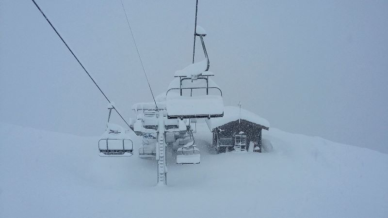
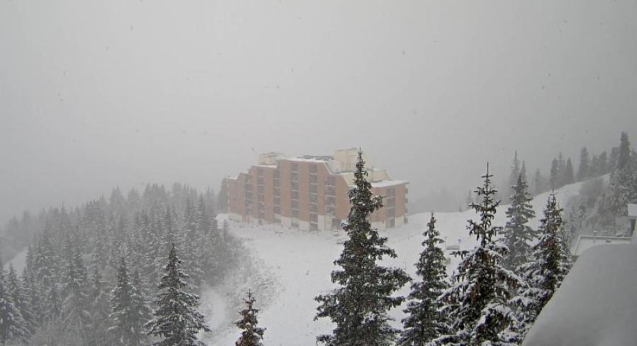
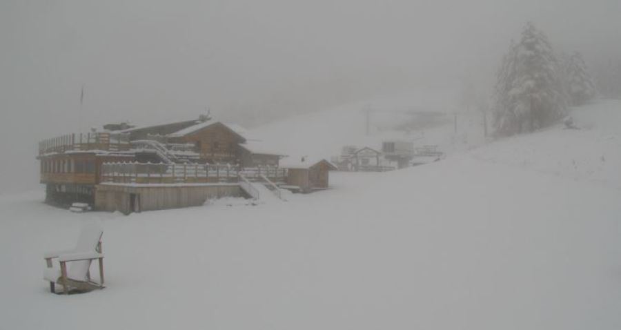
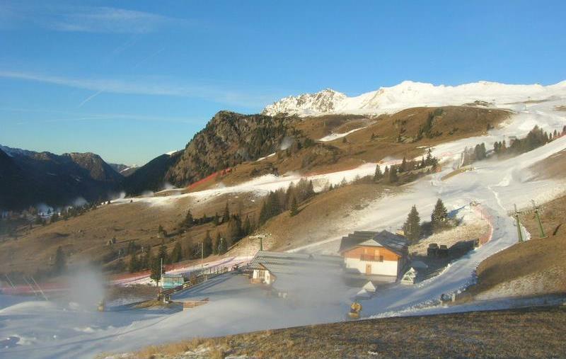 Snow-making is well underway in the Dolomites. This is San Pellegrino – 30 November 2016 – Photo: meteocam.it
The best skiing conditions can be found in the resorts of the western and south-western Alps which have most of their slopes above 2000m - such as Val d’Isère, Tignes, Cervinia and Zermatt - though it should also be noted that large scale snow-making is underway in a number of areas, especially in the eastern Alps where it will be coldest this week (e.g. Dolomites).
However, apart from a little snow in the extreme eastern Alps at the end of the week, there is little snow forecast for the foreseeable future (by that we mean at least 10 days).
Updated: 10.15am Tuesday 29 November 2016 - Blue skies for most
High pressure is firmly in charge of the Alps and will continue to dominate the weather (give or take) for the foreseeable future. We say give or take because a cold front will clip the eastern Alps later on Thursday and on Friday, with a little snow for the eastern Austrian Alps. However, for the vast majority of regions it will remain fine and dry all of this week, and probably most of next week as well.
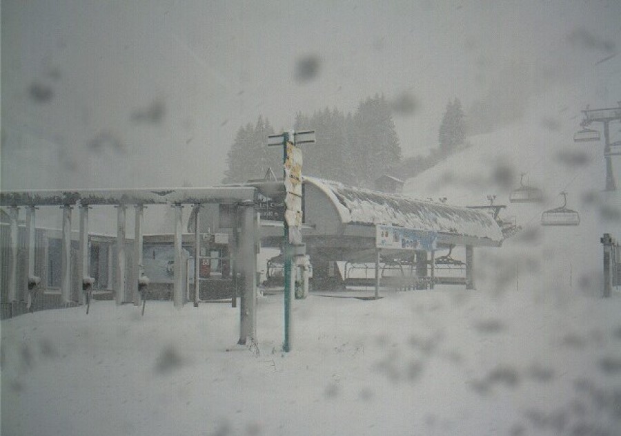
 Picture perfect on the slopes of Tignes yesterday – 29 November 2016 – Photo: facebook.com/celine.guillermin
Snow conditions in the Alps remain very mixed. High resorts in the western/south-western Alps are offering fabulous skiing right now thanks to last week’s huge snowfalls. The very best lift-served options (in our opinion) are still Val d’Isère, Tignes, Val Thorens, Cervinia and Zermatt, all of which have a lot of high altitude skiing.
There are also plenty of options further north and east, at least if you aim high, with Davos, St Moritz, Ischgl, Obergurgl and Obertauern all offering a good number of pistes on a mixture of natural and man-made snow.
Below about 1800-2000m though, snow cover is generally quite patchy or in some cases non-existent. The bad news for these areas is that, except for a little snow in the north-eastern Alps later on Thursday and Friday, there is no major dump in prospect for at least 10 days.
The good news though is that snow-making is in progress on an industrial scale, especially in the eastern Alps (e.g. Dolomites) where the temperatures are coldest.
Updated: 9.10am Monday 28 November 2016 - Mostly fine
Skiing conditions were superb in the western/south-western Alps over the weekend. Val d’Isère grabbed most of the headlines with prodigious quantities of new snow (at altitude) and blue skies for opening day on Saturday. However, lots of other resorts were also skiing superbly, including those in the Monte Rosa region, Cervinia, Saas-Fee, Zermatt and Val Thorens, to name just a few.
 Fabulous snow conditions in the Monte Rosa region yesterday – 27 November 2016 – Photo: facebook.com/monterosaski – Stefano Percino
So all is well in the higher resorts of the south-western Alps, however, we need to bear in mind that for most areas the recent mild weather has taken its toll and that, as a rule, there is still very little snow below 1800-2000m.
Some parts of Austria have woken up to a dusting of new snow this morning, and one or two early flurries are still apparent to relatively low altitudes in the north of the country. However, the vast majority of the Alps will by dry today, with plenty of sunshine above any low-lying cloud/fog. This settled theme will continue for much of the week, with plenty of fine weather and cool but not excessively cold temperatures.
A cold front will graze the north-eastern Alps on Thursday bringing some snow to low levels to parts of Austria – especially Upper Austria, Styria and the Salzburgland. Generally speaking though, there is no widespread new snow in view for at least 7-10 days.
Updated: 8.20am Saturday 26 November 2016 - Perfect timing by Val d’Isère
Val d’Isère gets underway today, and there can’t have been many better opening days than this! Yes it’s a bit of a mess at resort level – most of the precipitation from the recent storm fell as rain below 2000m – but skies have now cleared to reveal up to 2m of fresh snow at altitude.
 Looking fabulous minutes before the lifts opened in Val d’Isère this morning – 26 November 2016 - Photo: valdisere.com
2m of new snow in 36 hours is exceptional by any standards, but there was even more in the Maurienne where 2.5m fell in the high border areas above Bonneval-sur-Arc and Val Cenis. It is even possible that more than 3m came down in parts of the Italian Piedmont! Needless to say, avalanche danger is extremely high in these areas.
Now for a reality check. While some south-western parts of the Alps have seen exceptional amounts of snow at in recent days, most of the Alps are actually suffering due to 10 days or so of exceptionally mild weather. Yes, there is still reasonable cover above 2000m thanks to the big snowfalls earlier in the month but, lower down, snow is now patchy or non-existent. It will turn cooler over the next few days which should allow the snow cannons to operate, but there isn’t a huge amount of new snow in the medium term forecast.
In terms of where to find the best skiing this weekend, our top pick is Val I’Isère, which opens today to huge amounts of fresh snow, and links to neighbouring Tignes. Val Thorens is also skiing well, though snowfall totals here were much more modest.
In Switzerland, Zermatt and Saas-Fee remain the best options. There still isn’t much snow at resort level but conditions up top will be excellent.
In Italy the two best options are Cervinia and the Monte Rosa region, both of which have seen masses of new snow at altitude.
Snow conditions are not so good in Austria, which missed most of the recent snow. However, there are plenty of options available, the best of which are Sölden, Hintertux and non-glacial Ischgl, which offers the greatest extent of open pistes in the country.
Updated: 1.40pm Monday 25 November 2016 – Two metres of fresh snow?
A huge amount of snow has fallen at altitude in the border areas between France and Italy, from about Val d’Isère southwards, including resorts such as Val Cenis, Bonneval-sur-Arc, Bardonecchia and Sestriere.
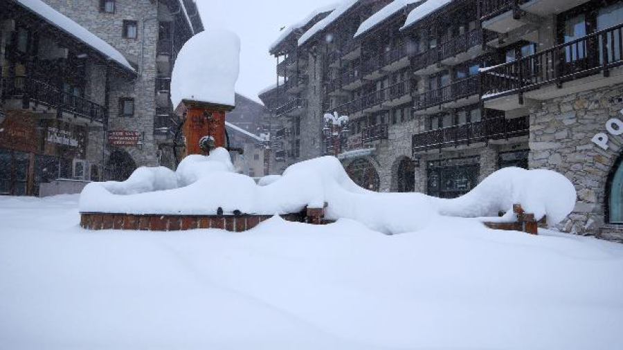
 2m of fresh snow at altitude in Val Cenis! – 25 November 2016 – Photo: facebook.com/ValCenis.officiel
Above 2500m, the above areas have seen 1.2m and 2m of snow (locally even more) in the last 36 hours alone. It has not been particularly cold, however, with the rain/snow limit somewhere around 1800-2000m – indeed there are reports of flooding in Val d’Isère this morning.
As anyone following the weather situation in the Alps will know, there has been plenty of rain/snow in other south-western parts of the Alps over this week, especially on the high ridges around and to the east of Zermatt/Cervinia, the Monte Rosa region, the Simplon area, and into the Swiss Ticino and Italian Lakes. Once again, however, the snowline has been relatively high - around 2300m in Zermatt and Saas-Fee, for example - but a little lower in some parts of Italy.
 Sestriere “buried in snow” early this morning – 25 November 2016 – Photo: vialattea.it
Today it will continue to snow intensively for a while in most of the above areas, especially around and to the south of Val d’Isère (snow 1700-2000m) before it eases off later in the day. Elsewhere in the Alps, there will be some showers here and there, but also lots of dry weather, especially in the north-eastern Alps (Austria).
For more on snow conditions in the Alps check out our detailed snow report filed yesterday. We will also bring you further updates on the huge storm that is currently affecting some south-western parts of the Alps later today.
Updated: 9.50am Thursday 24 November 2016 - Watch out Val d’Isère!
The southerly airflow that we have seen over the last few days has turned more to the south-east, which is now favouring the famous “Retour d’Est” (meaning ‘return from the east’), a weather phenomena which can bring prodigious amounts of snow to the French/Italian border regions around Val d’Isère/Tignes and the Maurienne (Val Cenis, Bonneval-sur-Arc). It can sometimes also affect the Milky Way area (Sestriere, Montgenèvre) and, further south, the less known Queyras and Mercantour region.
 Serious blizzard at altitude in Val d’Isère this morning – 24 November 2016 - Photo: valdisere.com
Sure enough it is snowing heavily above 1800-2000m this morning in the above mentioned regions (wet snow reported in Le Fornet in Val d’Isère at 9am). What’s more, it will continue all day and probably all night, with the potential for some massive quantities of snow at altitude – probably well in excess of 50cm above 2300m, possibly 100cm or more by tomorrow in one or two places.
This “Retour d’Est” will push a little further west to affect some other French resorts (e.g. 3 Valleys, La Plagne, Les Arcs) but here snowfall quantities will be much more modest.
 Heavy snow in Sestriere – 24 November 2016 – Photo: vialattea.it
As regular followers of weathertoski will know, there has also been some significant high altitude snow in north-west Italy and parts of southern Switzerland in recent days. Zermatt and Saas-Fee have had less than forecast (perhaps 50cm or so on their glaciers) but just to the east in the Monte Rosa region and across the Simplon area into the Swiss Tessin (where there are very few ski resorts) there has been well over 1m in places. Though, with the rain/snow limit around 2000-2300m, it has been wet lower down.
All this time, the northern Alps have been (and still are) affected by the Foehn, which has meant mostly dry but very mild and windy weather which has devoured much of the natural snow cover below about 1800m – though the degree of snow melt depends a lot on the precise geography of any given area.
Snow conditions in the Alps are therefore highly variable, but for Val d’Isère (which opens on Saturday) the timing could not be better, with better weather and huge amounts of fresh snow at altitude on the menu this weekend.
The top halves of Zermatt, Saas-Fee, Cervinia and the Monte Rosa Region will also be in excellent shape, as will any resort in the south-western quarter of the Alps that can open some runs above 2200m or so. For more details, check out our snow report which will be fully updated later today.
Updated: 9.30am Wednesday 23 November 2016 - Conditions in the Alps remain tricky
The weather in the Alps will hardly change today with a mild southerly airflow still dominating proceedings. On the southern side of the Alps it is mostly cloudy with showers, heaviest and most persistent in the south-west with snow above 2000-2300m. On the northern side there are one or two showers (especially in France) but, generally speaking, it is drier with a very mild Foehn wind.
 Huge snow falls at high altitude in the Monte Rosa region – 23 November 2016 – Photo: facebook.com/MonteRosaSki
We have already seen 1m or more of fresh snow from this storm above 2500m in north-western parts of Italy and the far south of Switzerland though, with rain below 2000-2300m, this has not always been obvious at resort level. Most of the snow has been in the high border areas to the east of Zermatt, through the Monte Rosa region, around the Simplon Pass and into the Swiss Tessin.
Tomorrow there will be a subtle change in the airflow towards the south-east, meaning that rain and snow will become a little more widespread across the western Italian Alps, also spilling more easily across the border into parts of the French Savoie, with some significant falls possible above 2300m in the likes of Val d’Isère and Val Cenis. However, at resort level it is still likely to fall as rain. By the weekend, the weather in the Alps will turn drier and cooler.
All this goes to show just how quickly snow conditions in the Alps can turn around at this time of year - just a week or so ago we were looking at the best snow cover for 20 years in some north-western parts of the Alps. Snow cover is still good at high altitude but the warmer weather has clearly has taken its toll lower down.
 Excellent snow cover high up in the Monte Rosa region, with plenty more to come today and tomorrow – 23 November 2016 – Photo: facebook.com/MonteRosaSki
Our pick of the best resorts to be heading to this weekend (once the current bad weather clears up) includes Tignes and Val d’Isère, the latter opening on Saturday to (we think) quite a lot of fresh snow above 2200m. Elsewhere in France, Val Thorens is the other top recommendation.
In Switzerland, Zermatt and Saas-Fee will have masses of snow at altitude even if cover is still patchy lower down. In Italy, Cervinia will be the best bet though higher parts of the Monte Rosa region will also be in excellent shape if (as planned) they manage to get some runs open here.
Austria will see very little fresh snow from this latest storm, however, the big news here is that Ischgl is opening tomorrow, with enough cover at altitude for some adequate piste skiing.
Updated: 10am Tuesday 22 November 2016 - Difficult times for the Alps
With a vigorous southerly airflow in place, the weather in the Alps is unfavourable for skiing right now. On the southern side of the Alps (especially in the south-west) we have a lot of precipitation though the rain/snow limit is generally above 2000m. Protected by the Foehn, the northern side of the Alps is drier but exceptionally warm - over 20°C in some valleys - and very gusty.
 Rapid loss of snow in the Austrian Vorarlberg due to the Foehn. This is Schröcken - 22 November 2016 - Photo: warth-schroecken.com
First some positives: there will be a lot of snow at high altitude in some south-western parts of the Alps over the next few days, including the likes of Cervinia, Zermatt, Saas-Fee and the Monte Rosa Region. These areas could see in excess of 1m (possibly even 2m) of snow above 2500m by the end of the week. Later in the week, particularly on Thursday, the flow will turn more to the south-east which will help the heaviest precipitation spill over the border into parts of France, such as Val d’Isère and Val Cenis. The rain/snow limit should also drop below 2000m.
Now for the negatives: for most of the Alps this southerly airflow spells bad news. Not only is the air latently mild, it also accelerates as it spills north over the main alpine ridges and is warmed further on its descent into the northern Alps, creating what we know as the ‘Foehn effect’. The temperature today in Salzburg, for example, is expected to reach 22°C! Needless to say, the rapid thaw of any low-lying snow will continue, and most low valleys will be green again by the end of the week, if they are not already.
 Whiteout conditions on the slopes of Cervinia - 22 November 2016 - Photo: cervinia.it
Looking a bit further ahead, the good news is that the Foehn will drop towards the end of this week and it will turn colder everywhere. We don’t have any concrete evidence of any widespread snow on the horizon, but there are signs that winter will attempt to return next week. Watch this space…
In the meantime, it is worth reminding ourselves that there is still lots of snow at high altitude in the Alps, especially in the north-west, even if skiing is being hampered by the strength of the wind right now. Once the weather does calm down, some of the best options will be Val Thorens, Tignes (joined by Val d’Isère this weekend), Zermatt/Cervinia and Saas-Fee.
Check out our detailed snow forecast updated later today…
Updated: 9.15am Monday 21 November 2016 - Five days of continuous snow for some south-western parts of the Alps
The Alps are under the influence of a strong southerly airflow which will dominate the weather until the end of the week. This will bring some extreme rainfall and snowfall totals to some central southern and south-western parts of the Alps over the next few days. By contrast, the northern Alps will stay mostly dry but very mild under the influence of the Foehn.
 Heavy snow this morning on the slopes of Airolo, in the far south of Switzerland - 21 November 2016 - Photo: airolo.ch
The heaviest snow will fall close to the Swiss-Italian border between Zermatt, Cervinia and the Italian lakes, including ski resorts such as Saas-Fee, the Monte Rosa region and Macugnaga. The rain/snow limit in these regions will start at around 1600-1800m today, but will more generally be closer to 2000m this week, which means that it will be very wet at resort level and you won’t notice much snow. At altitude, however, there will be some extreme quantities of snow – probably in excess of 2m above 2500m in places by the end of the week.
Most other south-western parts of the Alps will see plenty of showers this week, though the really extreme precipitation will always be relatively localised. The showers may also spill over the French border in places (e.g. Val d’Isère) especially later in the week.
Generally speaking though, the north side of the Alps will have a lot of dry, very mild and very windy weather this week (due to the Foehn) which will quickly devour any remaining low-lying snow. Above 2000m there is still a lot of snow for the time of year, especially in the north-western Alps, but we can no longer call the conditions here exceptional.
For more detail on what’s open and snow conditions in the Alps in general, check out our latest snow report which will be fully updated later today.
Updated: 10.20am Sunday 20 November 2016 - Extreme but localised snowfall imminent…
Yesterday we saw a short-lived polar maritime air mass bring snow to as low as 1000m in some northern and western parts of the Alps. It also snowed a bit on the southern side of the Alps but here the rain/snow limit never really fell below 1500m.
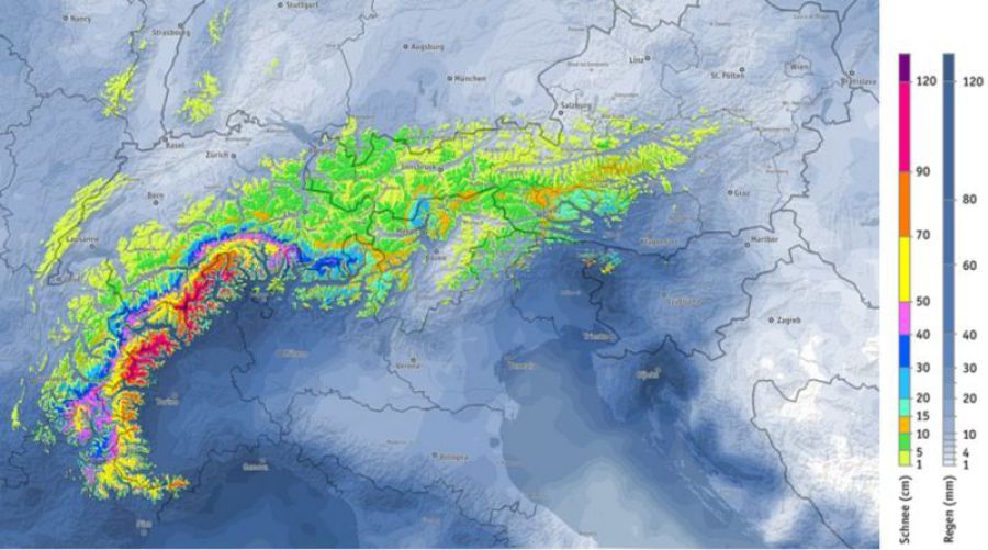 Between now and Friday extreme snowfall totals are possible in the north-western Italian Alps, spilling into parts of southern Switzerland and even France - Image: bergfex.com
Today we are back in a mild south-westerly airflow that will increase in strength and influence the weather in the Alps for several days. On the southern side of the Alps it will generally be cloudy with showers, and some more prolonged and intense precipitation (starting later today) in parts of the western Italian Alps and the southern Swiss Alps, possibly even spilling over the Italian border into parts of France.
The most extreme precipitation over the next few days is likely to be between Zermatt/Cervinia and the western Italian lakes, affecting resorts such as Saas-Fee, the Monte Rosa region and Macugnaga. These areas are all likely to see 1m to 1.5 m of snow at altitude this week, with some models predicting 3m or more! The rain/snow limit will start at around 1500-1700m but will tend to rise towards 2000m for a time mid-week before falling again later. However, it may remain lower than this under the most intense precipitation.
By contrast, on the northern side of the Alps the Foehn will be blowing (sometimes violently), with mostly dry but very mild weather which will quickly melt any low-lying snow. As we said earlier in the week, resorts with lots of skiing above 2000m are generally secure now for the season, but lower down the valleys will be very green again by the end of the week.
Before you start worrying too much though it should be stressed that is still only November! What’s more, it will turn colder again next week, with the hope of some more widespread snow towards the beginning of December.
In the meantime, there are now dozens of partially open ski areas open across the Alps. Glaciers aside, two of the bigger names now up and running are Val Thorens and Obergurgl, but there are also many smaller resorts open, at least at weekends.
Updated: 10am Saturday 19 November 2016 - Fresh snow for some
The weather situation is extremely complex right now, but many higher (and one or two lower) parts of the Alps are waking up to fresh snow this morning.
 Heavy snow at altitude in the Portes du Soleil this morning. This is Champéry – 19 November 2016 – Photo: telechampery.ch
Generally speaking the rain/snow limit is around 1200-1500m (but still falling) in the north-western Alps this morning, but closer to 2000m in the south-eastern Alps (e.g. Dolomites) though it will also lower here later in the day. Showers or longer periods of rain/snow will continue all day in the eastern half of the Alps but the weather should improve in the west this afternoon with the last of the showers falling as snow to around 1000m.
Snowfall totals from this storm will be very modest below 1500m but above 2000m many areas will have seen 10-20cm by the end of the day, with 30cm+ in one or two favoured locations, such as close to Mont Blanc.
After a relative lull in proceedings tomorrow morning, the weather will deteriorate in the south later in the day heralding the arrival of a vigorous southerly airflow that will dominate the Alpine weather for several days. This will bring intense precipitation to some central southern and south-western parts of the Alps, with serious snow at altitude for the likes of Zermatt, Saas-Fee and the Monte Rosa region.
By contrast, a strong Foehn will bring warmer, drier but often very gusty conditions to the northern side of the Alps, quickly melting any remaining low-lying snow.
Updated: 9.40am Friday 18 November 2016 - Rain and snow moving into the western Alps
After a mostly dry day yesterday, the weather is on the change again today, with rain and snow spreading into the western Alps. The rain/snow limit will be around 2000m (lower in parts of the western Italian Alps) before lowering more generally to between 1000m and 1500m tonight.
 Thickening cloud in Laax this morning, heralding the arrival of some rain/snow later – 18 November 2016 – Photo: laax.com
The eastern Alps will stay mostly dry today but will turn wetter tonight and tomorrow with a rain/snow limit sinking from around 2000m to 1000m – staying highest for longest in the south-east.
Generally speaking, most places will not see a huge amount of snow from this latest storm – typically 5-20cm above 2000m, but one or two favoured spots might see 30-50cm by the end of tomorrow. It will remain unsettled on Sunday and into next week, but with the Foehn developing, any snow will be increasingly confined to the southern side of the Alps (snow above 1500-1700m). On the northern side of the Alps, drier but warm and windy conditions will continue to thaw any remaining low-lying snow.
At altitude, snow cover remains excellent for mid-November, especially in the north-western Alps which bore the brunt of the recent storms. Resorts with lots of skiing above 2000m such as Val Thorens, Val d’Isère, Zermatt, Saas-Fee and Ischgl (to name just a few) are now pretty much secure for the season.
Lower down, however, there has been a steady thaw in recent days, which will next week be exacerbated by the Foehn on the northern side of the Alps. Don’t panic about the lack of snow lower down though - this is entirely normal at this time of year and there are still four weeks to go before the season proper is underway.
For more on snow conditions in the Alps and beyond, read our latest snow report.
Updated: 8.05am Thursday 17 November 2016 – Variable weather with some snow for most this weekend
Yesterday we had some rain to contend with in the north-eastern Alps, chiefly in Austria, with a relatively high rain/snow limit of between 2000m and 2400m. There was some fresh snow for most of the glaciers, especially in the north (e.g. Dachstein, Kitzsteinhorn). However, at low altitude much of last week’s snow has thinned or even disappeared completely.
 Mostly sunny above some low-lying clouds in the Monte Rosa Regions early this morning. This is Gressoney – 17 November 2016 - Photo: monterosa-ski.com
There is still quite a lot of cloud across the northern and eastern Alps this morning with a few residual showers (snow 2000), again chiefly in Austria. However, most of the Alps will be dry today with increasing amounts of sunshine the further south and west you are.
Tomorrow (Friday) will see a more pronounced deterioration in the weather in the western Alps with some snow, initially around 2000m dropping to 1500m later, and lower still overnight. On Saturday, the focus of the bad weather will start to move further east, while it brightens up as the day goes on in the west. There is still some uncertainty as to how things will pan out on Sunday but further showers are likely in places.
Early next week a strong Foehn will bring warm, dry but windy conditions on the northern side of the Alps but further showers on the southern side. For more on this, check out our more detailed forecast for the Alps tomorrow.
Snow conditions in the Alps remain excellent for mid-November even if some of the lower-lying snow from last week’s storms is now melting. The best of any fresh today is in the north-western Alps (e.g. Kitzsteinhorn, Dachstein), with further snow for most over the next two or three days.
Updated: 9.30am Wednesday 16 November 2016 - Mixed but mild
A warm front will bring some rain to the eastern side of the northern Alps today (especially in Austria). Most other areas will be dry with variable cloud, with the best of any sunshine in the southern Alps.
 High cloud spreading across the Portes du Soleil today, but it should stay dry - 16 November 2016 - Photo: chatel.com
The rain/snow limit will be relatively high today (2000-2300m) which means a steady thaw of any low-lying snow, especially in the north-eastern Alps. It will turn colder (with some snow) later on Friday and on Saturday, especially in the western Alps, but it won’t last long as milder weather is set to return on Sunday and continue well into next week.
Most of this week’s snow will fall later on Friday and on Saturday, heaviest in the western Alps where we may see 20-50cm at altitude. The rain/snow limit will be between 1300m and 1800m on Friday, lowering towards 1000m on Saturday. This colder weather will make less of an impact in the eastern Alps where any snowfall will be more modest.
Snow cover remains excellent at altitude across most parts of the Alps (especially the northern French, western Swiss and far north-western Italian Alps). However, next week will see Foehny (warm, windy but mostly dry) conditions across the northern Alps, which will mean a steady thaw of low-lying snow. The southern and south-western Alps will have cloudier weather and some snow at altitude.
For a general summary of snow conditions and open resorts in the Alps and beyond, please see our latest snow report (filed on Monday).
Updated: 8.15am Tuesday 15 November 2016 - Turning milder, but snow for some by the weekend
Pressure is high across the Alps today which means it will be dry with plenty of sunshine at altitude. Lower down there are areas of cloud/fog which may be slow to clear in places. From a skiing point of view though, conditions remain fabulous across all open areas with light winds and comfortable afternoon temperatures.
 Lots of sunshine at altitude across the Alps this morning - 15 November 2016 - Photo: hochkoenig.at
On Wednesday, a warm front will graze the northern Alps bringing more in the way of cloud and some showers, especially in northern Austria (dusting of snow above 2000-2200m). The bulk of the Alps will stay dry, however, with plenty of sun in the south.
Thursday will again see variable but mild weather in the northern Alps, but lots of sun in the south. By the weekend, it will turn colder again in the west, with snow returning to some parts of the Alps, this most likely in the south and west – see our detailed forecast this afternoon for further details.
Snow conditions in the Alps remain excellent for mid-November, especially in the north-western Alps, where settled snow depths are close to 1m above 2300m.
Milder weather this week will melt some of the lowest lying snow, especially close to the northern and north-eastern fringes of the Alps (where there will be some rain), but at altitude (say above 1800-2000m) the base is now assured just about everywhere.
In short, if you are planning an early ski trip in a resort with lots of skiing above 2000m, then you can be pretty sure there will be plenty of snow. For resorts where most of the skiing is below 2000m it is still too early to be sure. Stay with us for our daily updates on weather and snow conditions in the Alps….
For a more detailed look at where you can ski in the Alps right now please check our detailed snow report, filed yesterday.
Updated: 8.15am Monday 14 November 2016 - Bonus snow for parts of the north-west!
Good news this morning, with more snow falling in in the north-western Alps yesterday than expected. Most models/forecasts were indicating no more than a dusting, but this morning we have 10-15cm of new snow above 1800m (locally 20cm) in some parts of the northern French and Western Swiss Alps (e.g. Avoriaz, Verbier, Les Diablerets).
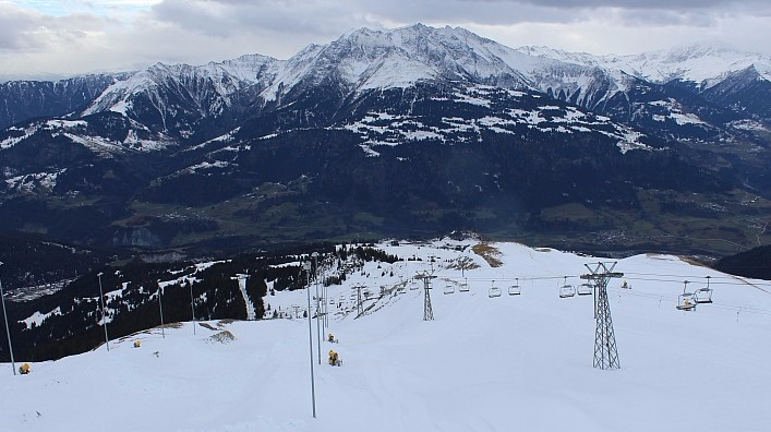
 A typical scene across the Alps this morning, with low cloud in the valleys but plenty of sunshine at altitude. This is Innsbruck - 14 November 2016 - Photo: foto-webcam.eu
Today there is still quite a lot of low cloud around but, the sun is dominant at altitude, and generally speaking we are looking at a pretty good weather day in the Alps. It will remain mostly dry with variable cloud over the next few days but the weather will turn increasingly unsettled again later in the week with the chance of further snow in many places by or before the weekend.
Snow conditions are exceptional for mid-November, with most high (and some low) resorts having now secured their base for the season. Indeed you would have to go back to 1996 to find a snowier November in the north-western Alps.
Most resorts that are open are skiing superbly today, but the very best snow conditions are in Les Diablerets (Glacier 3000) where there is an unexpected 15cm or so of bonus powder this morning.
For a more detailed analysis of where’s open right now, please see our latest snow report this afternoon.
Updated: 7.50am Sunday 13 November 2016 - Excellent snow conditions but mixed weather
After a glorious day in the western Alps yesterday, today will see more in the way of cloud with a scattering of showers. The rain/snow limit will remain quite low in the more internal valleys, but will rise to around 1500m in more exposed parts of the west, though we are not expecting more than a dusting here and there.
 Excellent snow cover in the Tux valley in Austria - 13 November 2016 - Photo: foto-webcam.eu
Snow conditions are exceptional for mid-November, especially in the north-western Alps where you would have to go back to 1996 to find anything comparable. However, it is worth noting that back then it hardly snowed again for the rest of the winter.
Back to the here and now, and more resorts have been opening in response to the exceptional early snow, albeit often in a very limited capacity. These include (among others) Alpe d’Huez in France, and Verbier and Crans Montana in Switzerland. For a more detailed overview of snow conditions and what is open, check out our full snow report on Monday.
Next week the weather in the Alps will start fairly benign with plenty of sunshine and relatively mild temperatures. However, colder weather with some snow may return later, especially in the west. Watch this space…
Updated: 7.40am Saturday 12 November 2016 - Powder day!
The sun is back out in the western Alps where we have an epic day’s skiing in prospect in the few (but increasing) number of resorts that are open. The weather is still variable with a few flurries in the far eastern Alps but here too it should brighten up by the end of the day.
 Blue skies and fresh powder snow in Saas-Fee today – 12 November 2016 – Photo: saas-fee.ch
Nowhere will be skiing better today than Tignes, where there is 60-90cm of new snow across the area and it should remain sunny all day. Alpe d’Huez is also open (weekends only) and in fabulous condition.
In Switzerland, Zermatt and Saas-Fee continue to be the main offerings but you can also ski (in a limited capacity) in Verbier, Glacier 3000, Engelberg, Laax and Diavolezza (near St Moritz). Of these, Verbier, Glacier 3000 and Engelberg have the deepest powder (60-100cm of new snow since Wednesday).
In Austria, all eight glaciers are open, though the weather here may be a little more variable early in the day, but will improve later. You can also ski in a very limited capacity in a handful of other resorts including Kitzbühel. All Austrian resorts have new snow, though not quite in the same quantities that we have seen further west.
In Italy you can ski in Cervinia, Val Senales and Solda. Of these, Cervinia has seen the most new snow from this latest storm cycle and offers the greatest extent of open pistes.
The next few days will be mostly dry and relatively mild but winter should return towards the tail end of next week. Stay tuned!
Updated: 8.45am Friday 11 November 2016 - 1m + of new snow in places!
It’s been snowing non-stop for 48 hours in some north-western parts of the Alps where, at altitude, storm totals have surpassed 1m in places. There will be further snow across the northern Alps today before brighter weather edges into the west later. With one or two exceptions, the southern Alps have seen less snow from the current storm, with some places missing out altogether.
 60cm of new snow in Val d’Isère this morning! - 11 November 2016 - Photo: facebook/radio-tv-valdisere
The greatest snowfall totals have been in the northern French, extreme western Swiss Alps, and extreme north-western Italian Alps, with between 60cm and 90cm of new snow above 2200m since Wednesday (locally 1m+).
More generally speaking we have seen between 40cm and 70cm of new snow at altitude across the north-western Alps, with snow settling to below 1000m in most places. There will also be further accumulations of snow (10-40cm) across the northern Alps today before it starts to ease from the west later. The rain/snow limit will be between 500m and 1000m.
 Deep snow cover in Europe’s highest ski resort, Val Thorens - 11 November 2016 - Photo: facebook.com/valthorens
Saturday will see the last of the flurries move away from the eastern Alps and, with the sun coming out in many areas, we have an exceptional powder day in prospect for those lucky enough to find themselves close to an open ski area (or who can be bothered to skin up the mountain themselves). Note, however, that the risk of avalanche off-piste is considerable.
Snow conditions in the Alps are exceptional for mid-November - you would have to go back to 1996 to find anything comparable in the north-western Alps - though there have been snowier Novembers in recent years in both the eastern and the southern Alps.
 Masses of new snow in the 3 Valleys. This is Méribel – 11 November 2016 – Photo: merinet.com
Right now, weather-permitting, you can ski in Austria on the glaciers at Hintertux, Stubai, Kaprun, Sölden, Mölltal, Pitztal, Kaunertal and Dachstein. Of these, the first four offer the greatest extent and variety. You can also ski in the Resterhöhe area of Kitzbühel, though in a very limited capacity. No doubt there will be other unscheduled openings shortly.
In Switzerland (weather-permitting) you can ski on the glaciers at Zermatt, Saas-Fee, Glacier 3000, and Diavolezza. Zermatt and Saas-Fee offer by far the greatest variety and extent of terrain. The glacier at Engelberg is currently closed for maintenance but you will be able to ski between Stand and Trübsee this weekend. Verbier will also try to open a couple of non-glacial runs in its Lac de Vaux area today, where there is about 70cm of powder!
 While most of the southern side of the Alps missed the heaviest of the snow, Courmayeur got dumped on (thanks to its proximity to Mt Blanc) – 11 November 2016 – Photo: bergfex.com
In Italy you can ski on the glaciers at Val Senales and Cervinia, but Passo Stelvio is now closed for the winter. A handful of non-glacial runs are also open at Solda (Sulden).
In France, Tignes is the only resort that is properly open. Today (weather permitting) they also plan to open the long double M run off the glacier to Val Claret. Courchevel also plans to open for a special free “preview” today only, and Alpe d’Huez is set to join the action for a pre-season taster this weekend. All three resorts have masses of new snow.
Updated: 8.50am Thursday 10 November 2016 - More snow, chiefly in the north and west
A cold and unstable north-westerly airflow continues to dominate the weather in the Alps. Over the next 24 to 36 hours we can expect plenty more snow across the northern half of the Alps before it turns drier and brighter from the west later on Friday, then just about everywhere by Saturday. The southern Alps will again miss the heaviest of the snow, with some places remaining completely dry.
 Lots of snow in Avoriaz with plenty more to come today - 10 November 2016 - Photo: avoriaz.com
Looking back at Wednesday and it snowed on and off across the north-western Alps, though perhaps not as heavily as originally forecast. Nevertheless we still saw some 15-30cm of fresh snow above 1800m in the northern French and the western Swiss Alps, with a rain/snow limit starting very low then rising to between 800m and 1100m later. Some useful snow also eventually reached the north-eastern Swiss and western Austrian Alps but the southern Alps escaped the heaviest of the precipitation.
Today, showers or longer spells of snow (700-1100m) are again affecting the northern Alps, heaviest in the north-west (from the French Savoies, through Switzerland and into the Vorarlberg) where another 20-40cm of new snow is possible by Friday morning (locally even more). Talking of Friday, early snow will die out in the north-western Alps but continue further east, especially in the eastern Swiss and Austrian Alps.
Saturday will see the last of any flurries clear the eastern Austrian Alps then many places will be dry with some sunshine, though it may cloud over again in the far west later. Sunday will be cloudy in the west with a little rain (snow above 1500m). Further east it should be drier and brighter.
 Plenty of snow at resort level in La Rosière - 10 November 2016 - Photo: larosiere.net
Snow conditions in the Alps are excellent for early November with a lasting base now likely above 1800m in many (though perhaps not quite all) parts of the Alps. Watch out for some unscheduled openings over the coming days in response to all this new snow. Verbier, for example, plans to open its Lac de Vaux area tomorrow. Courchevel will also open for a day of free skiing (really just a publicity stunt).
Right now, weather-permitting, you can ski in Austria on the glaciers at Hintertux, Stubai, Kaprun, Sölden, Mölltal, Pitztal, Kaunertal and Dachstein. Of these, the first four offer the greatest extent and variety. You can also ski in the Resterhöhe area of Kitzbühel though in a very limited capacity.
In Switzerland you can ski on the glaciers at Zermatt, Saas-Fee, Glacier 3000, and Diavolezza. Zermatt and Saas-Fee offer by far the greatest variety and extent of terrain. The glacier at Engelberg is currently closed for maintenance.
In Italy you can ski on the glaciers at Val Senales and Cervinia, but Passo Stelvio is now closed for the winter. A handful of non-glacial runs are also open at Solda (Sulden).
In France you can only ski on the glacier above Tignes as Les 2 Alpes is now closed until December.
Updated: 10.20am Wednesday 9 November 2016 - Heavy snow in the west, brighter in the south and east
An area of low pressure is sliding towards the Alps from the north-west. This means plenty more snow today for the northern French, northern and western Swiss Alps. The further south and east you are, however, the better the weather will be with relatively bright skies for much of Austria (away from the far west) as well as large parts of the Italian Alps (away from the north-west).
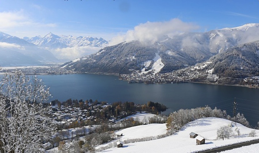 Winter wonderland in Zell-am-See this morning - 9 November 2016 - Photo: zellamsee-kaprun.com
Today’s snow will be heaviest in the northern and western Swiss Alps (e.g. Courchevel, Avoriaz, Verbier) and will fall to low altitudes – generally to 600-1000m, but lower still in some valleys. By tomorrow morning, 20-40cm is expected by tomorrow morning above 1500m, locally a bit more.
It will continue snowing on and off across most of the northern and western Alps on Thursday and at first on Friday, including in Austria, though always heaviest in the west (from the northern French Alps through Switzerland, and into the Austrian Arlberg and west Tirol). By the end of the week some north-western parts of the Alps will see 1m or more of new snow. However, as we intimated earlier, the southern Alps will see less snow from this series of storms, with some spots missing out altogether.
It will remain rather unsettled but turn milder over the weekend.
 Snowing in the western Alps this morning. This is Chamrousse - 9 November 2016 - Photo: chamrousse.com
Snow conditions in the Alps are excellent for early November and will only improve further as the week goes on. Watch out for some unscheduled openings over the coming days in response to all this new snow…
Right now, weather permitting, you can ski in Austria on the glaciers at Hintertux, Stubai, Kaprun, Sölden, Mölltal, Pitztal, Kaunertal and Dachstein. Of these, the first four offer the greatest extent and variety. You can also ski in the Resterhöhe area of Kitzbühel though in a very limited capacity.
In Switzerland you can ski on the glaciers at Zermatt, Saas-Fee, Glacier 3000, and Diavolezza. Zermatt and Saas-Fee offer by far the greatest variety and extent of terrain. The glacier at Engelberg is currently closed for maintenance.
In Italy you can ski on the glaciers at Val Senales and Cervinia, but Passo Stelvio is now closed for the winter. A handful of non-glacial runs are also open at Solda (Sulden).
In France you can only ski on the glacier above Tignes as Les 2 Alpes is now closed until December.
Updated: 7.50am Tuesday 8 November 2016 - Wintry, with further snow in the forecast
It’s a wintry scene across the Alps this morning with freezing cold temperatures and snow to relatively low levels in many areas. What’s more, there is more snow to come, especially in the north-western Alps where a series of major storms could deliver 1m or more between Wednesday and Saturday.
 Excellent snow cover for early November in Lech - 8 November 2016 - Photo: lechzuers.com
Today most areas are dry with sunny spells, though there are a few light snow flurries around, both in the far south-eastern Alps and, more particularly, in the north-western Alps where they will become more widespread later in the day. A few cm of additional snow is therefore possible to low levels in such areas as the Portes du Soleil and the Bernese Oberland.
 A wintry looking scene in Astental in the southern Austrian Alps - 8 November 2016 - Photo: foto-webcam.eu
All eyes are, however, on what is going to happen tomorrow onwards as a series of storms barrel in to the Alps from the north-west. These will deliver serious snow to the north-western Alps - by which we mean the northern French Alps, the extreme north-western Italian Alps, most of the Swiss Alps (away from the far south) and the far west of Austria.
Above 2000m these areas could see 1m or more of snow by the weekend, and also snow to much lower levels for a time before it eventually turns milder. Find out more with our detailed snow forecast for the Alps later today…
 Light snow falling again in the Portes du Soleil this morning. This is near Champéry - 8 November 2016 - Photo: idelec.ch
Snow conditions in the Alps are therefore impressive for early November and will get even better as the week goes on. We would even go so far as to say that, above 2000m, the base is (or soon will be) secure for the season in most (if not quite all) Alpine areas.
Right now, weather permitting, you can ski in Austria on the glaciers at Hintertux, Stubai, Kaprun, Sölden, Mölltal, Pitztal, Kaunertal and Dachstein. Of these, the first four offer the greatest extent and variety. You can also ski in the Resterhöhe area of Kitzbühel on a strip of “managed” snow preserved over the summer.
In Switzerland you can ski on the glaciers at Zermatt, Saas-Fee, Glacier 3000, and Diavolezza. Zermatt and Saas-Fee offer by far the greatest variety and extent of terrain. The glacier at Engelberg is currently closed for maintenance for a couple of weeks.
In Italy you can ski on the glaciers at Val Senales, and Cervinia, but Passo Stelvio is now closed for the winter. A handful of non-glacial runs are also open at Solda (Sulden).
In France you can only ski on the glacier above Tignes as Les 2 Alpes has now closed again until December.
For more on snow conditions, read our latest snow report (published yesterday afternoon)…
Updated: 9.30am Monday 7 November 2016 - Winter takes control of the Alps
Winter has well and truly arrived in the Alps, with significant fresh snow at altitude just about everywhere. In many regions it has also snowed to quite low levels and there is plenty more in the forecast this week.
 Fresh snow to low levels in the Austrian Vorarlberg this morning. This is Schröcken at just 1250m - 7 November 2016 - Photo: warth-schroecken.com
Looking back at the weekend, and on Saturday most of the snow was in the western Alps where it fell as low as 1200m for a time in the more sheltered valleys of the western Italian Alps (e.g. Courmayeur). More generally, however, the rain/snow limit was above 2000m, at least until Saturday evening, when the colder air began to dig in from the north-west.
By Sunday, the most persistent precipitation had transferred further east, with a rain/snow limit between 1500m and 2200m, decreasingly steadily as the day went on. Further west the snow turned more showery, but fell increasingly to below 1000m as the day wore on. However, it wasn’t until Sunday night that the colder air finally reached the far south-eastern Alps (e.g. Carinthia, Dolomites).
This morning there is still an arc of snow showers (500-1000m) stretching right across the northern and eastern Alps all the way from the French Haute-Savoie through the northern Swiss Alps, into Austria and trailing down into the eastern Italian Alps. By contrast, most of the southern, and particularly the south-western Alps, are dry and quite sunny.
 Looking great this morning in Courchevel, though it will be a few weeks before the season kicks off here - 7 November 2016 - Photo: courchevel.com
The weather in the Alps will remain cold and unsettled for much of this week, perhaps turning a little milder towards the weekend. There will also be further snow at times, heaviest in the northern and western Alps later on Wednesday and through Thursday.
So where in the Alps has seen the most fresh snow from this storm? In terms of the ski areas that are currently open, it is probably Hintertux, which is claiming at least 60cm of new snow on the glacier and where it is still snowing this morning. No doubt some other parts of the nearby “main alpine ridge” have had even more.
Other regions, such as the Massif du Mont Blanc (both the French and Italian sides) have also seen more than half a metre at altitude but, more generally speaking, we are looking at between 15cm and 40cm of fresh snow at 2500m.
Whatever the case, this is a very promising start to the 2016-17 Alpine season and, with more snow in the forecast, in many regions a high altitude base is already (or soon will be) secured.
 60cm of new snow on the glacier at Hintertux - 7 November 2016 - Photo: facebook.com/hintertux.gletscher
Right now, weather permitting, in Austria you can ski on the glaciers at Hintertux, Stubai, Kaprun, Sölden, Mölltal, Pitztal, Kaunertal and Dachstein. Of these, the first four offer the greatest extent and variety. You can also ski in the Resterhöhe area of Kitzbühel on a strip of “managed” snow preserved over the summer.
In Switzerland you can ski on the glaciers at Zermatt, Saas-Fee, Glacier 3000, and Diavolezza. Zermatt and Saas-Fee offer by far the greatest variety and extent of terrain. The glacier at Engelberg is closed for maintenance for a couple of weeks.
In Italy you can ski on the glaciers at Val Senales, and Cervinia but Passo Stelvio is now closed for the winter. A handful of non-glacial runs are also open at Solda (Sulden).
In France you can only ski on the glacier above Tignes as Les 2 Alpes has now closed again until December.
Updated: 10am Sunday 6 November 2016 - “Big storm” in full swing
The much anticipated “big storm” is now in full swing. Yesterday the heaviest rain/snow was in the western Alps but today the focus will move further east.
 40cm+ of new snow at altitude in Alpe d’Huez - 6 November 2016 - Photo: alpedhuez.com
On Saturday we saw a lot of precipitation across the western Alps though, with milder air in the mix, the rain/snow limit remained above 2000m for much of the day in the northern French and western Swiss Alps before lowering rapidly after dark.
By contrast, due to so-called “orographic cooling” it snowed to much lower levels in the western Italian Alps (and some parts of the southern French Alps), as low as 1200m, for example, in Courmayeur on the Italian side of Mt Blanc.
Today the heaviest and most persistent precipitation will be in the eastern Alps. In the far south-eastern Alps the rain/snow limit is still quite high (close to 2000m) but in western Austria it is already closer to 1000m, and the colder air will continue its eastward progress to reach all areas by the end of the day. Further west, the precipitation will be more showery but any snow will fall to very low levels (500-1000m).
 Looking wintry this morning in Avoriaz, with a dusting of snow even down to Morzine - 6 November 2016 - Photo: avoriaz.com
It’s too early to say just how much snow has fallen, and eastern parts of the Alps are yet to see the bulk of their share, so we will make a more thorough assessment tomorrow. However, we already have reports of 40cm+ at altitude in parts of the French and western Italian Alps (e.g. Sestriere, Courmayeur, Alpe d’Huez) and, by tomorrow, there should be a significant layer of snow above 2200m just about everywhere.
What’s more, it will stay unsettled and relatively cold all week with further snow at times. All in all it’s a very promising start to the season, at least compared to recent years…
 Lots of new snow in the Milky Way area. This is Sestriere - 6 November 2016 – Photo: vialattea.it
Weather permitting, in Austria you can ski on the glaciers at Hintertux, Stubai, Kaprun, Sölden, Mölltal, Pitztal, Kaunertal and Dachstein. Of these, the first four offer the greatest extent and variety. You can also ski in the Resterhöhe area of Kitzbühel on a strip of “managed” snow preserved over the summer.
In Switzerland you can ski on the glaciers at Zermatt, Saas-Fee, Glacier 3000, Engelberg and Diavolezza. Zermatt and Saas-Fee offer by far the greatest variety and extent of terrain.
In Italy you can ski on the glaciers at Val Senales, and Cervinia. A handful of non-glacial runs are also open at Solda (Sulden).
In France you can only ski on the glacier above Tignes as Les 2 Alpes has now closed again until December.
Updated: 10am Saturday 5 November 2016 - Rain and snow hits the Alps
The much anticipated “big storm” has arrived though, as expected, there are huge variations in the rain/snow limit this morning. Today the bulk of the precipitation will be in the western and southern Alps, but tomorrow the “centre of gravity” will move further east.
 Heavy snow this morning in Sestriere in the Italian Piedmont - 5 November 2016 - Photo: vialattea.it
At first light this morning we can see clearly that it has been snowing to relatively low levels (1200-1400m) in the western Italian Alps (e.g. Courmayeur, Sauze d’Oulx) thanks to so-called “orographic cooling”. Snow has also fallen to low levels in the southern French Alps close to the Italian border but, generally speaking, the rain/snow limit in the French and Swiss Alps is between 2000m and 2300m.
As today progresses, the snow-line on the southern side of the Alps will rise (to between 1600m and 2200m by midnight), at the same time lowering on the northern and western side of the Alps (to between 1100m and 1700m by midnight).
 Snowing this morning in Abriès, close to the Italian border in the southern French Alps - 5 November 2016 - Photo: queyras-montagne.com
By tomorrow morning, the precipitation should have turned more showery in the western Alps but, with colder air digging in, the rain/snow limit should be closer to 1000m, and will lower further still as the day progresses. The heaviest of the rain/snow will reach the eastern Alps (i.e. Austria) tonight and linger for much of Sunday, with the snow line also descending from above 1500m to under 1000m later in the day.
Only the far southern Austrian Alps and the Dolomites are likely to hang on to the milder air until the end of Sunday (snow 2000m+ until Sunday night).
 Snowy scenes this morning in Bardonecchia in the Italian Piedmont - 5 November 2016 - Photo: bardonecchiaski.com
Between now and Monday we can expect a significant fall of snow at altitude for just about all Alpine regions - typically 20-50cm at 2500m, but 75cm+ in some favoured locations. These might include the northern end of the southern French Alps (e.g. Les 2 Alpes), the border areas between south-east Switzerland and Lombardy (between St Moritz and Livigno), the western Trentino (e.g. Passo Tonale) and the Austrian main Alpine ridge (e.g. Heiligenblut, Mallinz).
Snow will also settle to much lower levels as the weekend progresses, so don’t be surprised to see a dusting to 1000m or below in many places by Monday.
It will remain unsettled next week with further snow at times, initially to low levels, a bit higher later. Stay tuned!
Updated: 8.40am Friday 4 November 2016 - The calm before the storm
There’s one more day of fine weather in the Alps before it turns very unsettled over the weekend, bringing significant snowfall to most regions, at least at altitude.
 The calm before the storm. A lovely morning on the glacier above Saas-Fee but note the “hat” on the Alphubel mountain, a tell-tail sign of a changes to come - 4 November 2016 - Photo: saas-fee.ch
Many places will enjoy some sunshine today but there are some areas of cloud around, and cloud will thicken up more generally in the west later in the day, heralding the approach of the storm.
Tomorrow will be very wet in the western Alps with a rain/snow limit starting around 2400m (lower in the south, particularly in Italy), lowering to between 1300m and 1800m later. Some eastern parts of the Alps will start dry but will also turn wet later in the day, or at the latest on Saturday night.
On Sunday the heaviest precipitation will be in the eastern Alps while it turns more showery in the west. The rain/snow limit will remain close to 2000m in the far south-east for a time but, more generally speaking, will fall to below 1000m.
As for how much snow will fall between Saturday and Monday, we can expect between 20cm and 50cm quite widely above 2200m with the potential for 75cm+ in some favoured spots. According to the latest models, such spots might include the northern part of the southern French Alps (between Les 2 Alpes and Serre Chevalier), the main alpine ridge between south-eastern Switzerland and Italy (close to St Moritz), and the main Alpine ridge in the central/south-eastern Austrian Alps (e.g. Heiligenblut, Mallintz).
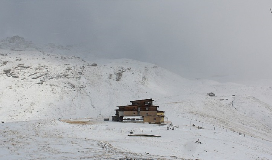
 Berggasthof Wallackhaus near Heiligenblut close to the Tirol/Carinthia border. This is one area that could do very well from the weekend storm - 4 November 2016 - Photo: foto-webcam.eu
Snow will also fall to lower levels, though generally in more modest quantities, firstly in the western Alps, then later in the south-eastern Alps where the milder air will hang on for longest. Don’t be surprised to see a dusting to below 1000m in places by the end of Sunday. Next week will remain cold and unsettled with the chance of further snow to low levels at times.
For more details, check out our first full length snow forecast of the season a little bit later today…
In the meantime, in Austria you can ski on the glaciers at Hintertux, Stubai, Kaprun, Sölden, Mölltal, Pitztal, Kaunertal and Dachstein. Of these, the first four offer the greatest extent and variety. You can also ski in the Resterhöhe area of Kitzbühel on a strip of “managed” snow preserved over the summer.
In Switzerland you can ski on the glaciers at Zermatt, Saas-Fee, Glacier 3000, Engelberg and Diavolezza. Zermatt and Saas-Fee offer by far the greatest variety and extent of terrain.
In Italy you can ski on the glaciers at Val Senales, Passo Stelvio and Cervinia. A handful of non-glacial runs are also open at Solda (Sulden).
In France you can only ski on the glacier above Tignes as Les 2 Alpes has now closed again until December.
Updated: 10.10am Thursday 3 November 2016 - A little snow in places and a whole lot more to come!
As expected, some north-eastern parts of the Alps are waking up to a dusting of snow this morning. Although the snow fell as low as 1000m in the northern Austrian Alps, it really hasn’t amounted to much across the Alps in general - just a few cm above 1200-1500m in the north-east. All eyes are now on this weekend when a much more active storm will reach the Alps bringing significant quantities of snow in places.
 A dusting of snow above Zürs this morning - 3 November 2016 - Photo: lech-zuers.at
Before this, the Alps will enjoy a couple of days of relatively clement weather. Today the last of the snow flurries (700-1100m) will clear the eastern Austrian Alps leaving most areas with a fine, bright day. Friday will also be mostly fine, but cloud will increase in the western Alps later heralding the arrival of the “big weekend storm”.
The western half of the Alps will see the heaviest of the precipitation on Saturday, before the main focus of the storm transfers further east on Sunday. The rain/snow limit will be quite high at first – starting at around 2400m in the north-western Alps on Saturday (though lower further south, particularly in Italy) before lowering more generally on Saturday night and through Sunday. By the end of the weekend, the colder air will have made it across the entire Alps sending the snow line to between 500 and 1200m.
By early next week we can expect the first widespread and significant covering of snow of the season for the Alps (30-50cm above 2200m for most places, locally more) with snow settling to quite low levels by Sunday/Monday. What’s more, it will stay cold and unsettled next week which means that much of this snow will stick around, and in some spots continue to accumulate. It’s too early to say that we are in for a bumper early season but we certainly have the makings of a decent high altitude base and the general trend is very promising.
 A few cm of snow last night on the main Alpine ridge close to the Grossglockner - 3 November 2016 - Photo: foto-webcam.eu
In the meantime, in Austria you can ski on the glaciers at Hintertux, Stubai, Kaprun, Sölden, Mölltal, Pitztal, Kaunertal and Dachstein. Of these, the first four offer the greatest extent and variety. You can also ski in the Resterhöhe area of Kitzbühel on a strip of “managed” snow preserved over the summer.
In Switzerland you can ski on the glaciers at Zermatt, Saas-Fee, Glacier 3000, Engelberg and Diavolezza. Zermatt and Saas-Fee offer by far the greatest variety and extent of terrain.
In Italy you can ski on the glaciers at Val Senales, Passo Stelvio and Cervinia. A handful of non-glacial runs are also open at Solda (Sulden).
In France you can only ski on the glacier above Tignes as Les 2 Alpes has now closed again until December.
Updated: 10.30am Wednesday 2 November 2016 – A little snowfall for the north-eastern Alps before the main event this weekend!
The weather in the Alps is about to turn very interesting. Today we have a weak cold front arriving from the north which will give a little snow chiefly to the north-eastern Alps. Over the weekend, however, a much more potent and complex storm will bring much heavier snow (and rain) to most regions.
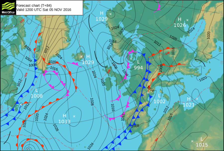 Met Office pressure chart for Saturday showing fronts piling into the Alps – Image: metoffice.gov.uk
Back to today and the cold front is already approaching the foothills of the northern Austrian Alps where it will soon rain (with snow initially only above 1500-1800m). The bulk of the precipitation today will remain in the northern Austrian Alps (Vorarlberg, Tirol, Salzburgland, Upper Austria, western Styria) as well as the far east of Switzerland, with the rain/snow limit lowering to between 900m and 1400m later in the day.
Quantities of snow in in the north-eastern Alps today will be modest, typically just 2-10cm above 1800m but 15cm+ in a few favoured locations. Except for a few showers in some other northern parts of the Alps, most other regions will be dry, with the best of the sunshine (and higher temperatures) in the south and south-west.
After a mostly fine and relatively mild day again on Friday, a much bigger change in the Alpine weather is expected on Saturday. The bad weather will affect the south-western Alps at first, but will spread to all other regions during the course of the weekend. There will be huge variations in temperature during this storm before it finally turns colder everywhere by Sunday night.
Due to the very complex nature of this storm, it is very difficult to accurately predict how much snow will fall, but suffice it to say that most Alpine regions will have a significant covering at altitude by Monday. What’s more, it looks like staying cold next week, which means the snow should stick around too…
We will have more detailed look at who is likely to get the most snow tomorrow.
In the meantime, in Austria you can ski on the glaciers at Hintertux, Stubai, Kaprun, Sölden, Mölltal, Pitztal, Kaunertal and Dachstein. Of these, the first four offer the greatest extent and variety. You can also ski in the Resterhöhe area of Kitzbühel on a strip of “managed” snow preserved over the summer.
In Switzerland you can ski on the glaciers at Zermatt, Saas-Fee, Glacier 3000, Engelberg and Diavolezza. Zermatt and Saas-Fee offer by far the greatest variety and extent of terrain.
In Italy you can ski on the glaciers at Val Senales, Passo Stelvio and Cervinia. A handful of non-glacial runs are also open at Solda (Sulden).
In France you can now only ski on the glacier above Tignes, as Les 2 Alpes is now closed again until December.
Updated: 6.30am Tuesday 1 November 2016 - Another fine day but major pattern change still within view
There’s another sunny and mild day in store for the Alps, at least above any lowland cloud/fog patches. Tomorrow a weak cold front will bring a little rain/snow to the north-eastern Alps but we will have to wait until the weekend before we see more widespread precipitation.
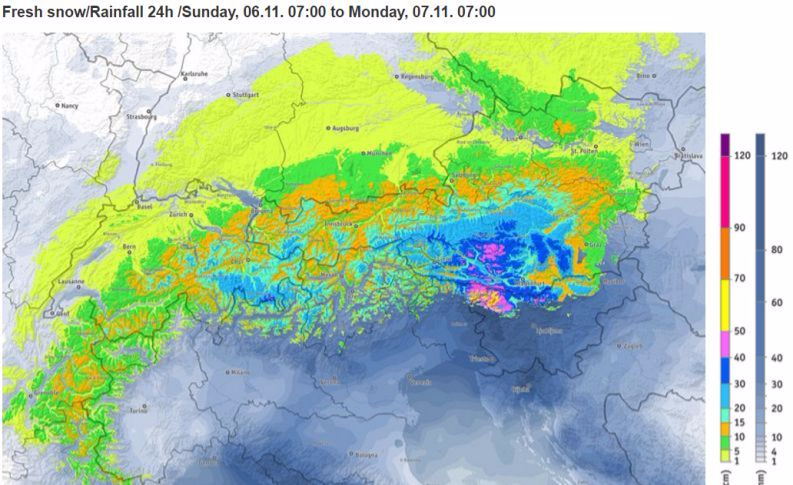 Sneak preview of estimated snowfall in the Alps for Sunday 6 November 2016 - Image: bergfex.com
Tomorrow’s snow will be modest in nature (a few cm) and confined to the north-eastern Alps – with a rain/snow limit sinking to 1000-1500m. Most other parts of the Alps will be dry with plenty of sunshine in the south and west.
On Thursday, the last of the showers (snow 1000m) will die away from the Austrian Alps and most places will again enjoy a fine day. On Friday, the eastern Alps will see the best of any sunshine as cloud thickens in the west later.
The weekend then looks unsettled with periods of rain or snow and, after a mild start, increasingly cool temperatures. The models keep chopping and changing which means it is too early to say who will see the most snow, however, there is the potential for some significant falls in places.
In the meantime, the current fine weather means there is some very enjoyable skiing to be had on the glaciers (and in one or two non-glacial resorts).
In Austria you can ski on the glaciers at Hintertux, Stubai, Kaprun, Sölden, Mölltal, Pitztal, Kaunertal and Dachstein. Of these, the first four offer the greatest extent and variety. You can also ski in the Resterhöhe area of Kitzbühel on a strip of “managed” snow preserved over the summer.
In Switzerland you can ski on the glaciers at Zermatt, Saas-Fee, Glacier 3000, Engelberg and Diavolezza. Zermatt and Saas-Fee offer by far the greatest variety and extent of terrain.
In Italy you can ski on the glaciers at Val Senales, Passo Stelvio and Cervinia. A handful of non-glacial runs are also open at Solda (Sulden).
In France you can ski on the glaciers above Tignes and Les 2 Alpes, though the latter will be closed from tomorrow until December.