

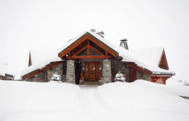
Updated: 8.45am Sunday 31 January 2016 - Serious bad weather day in the northern Alps!
As expected, the weather is pretty wild across the northern Alps this morning, especially in the north-west, with a mixture of heavy snow, rain and high winds.
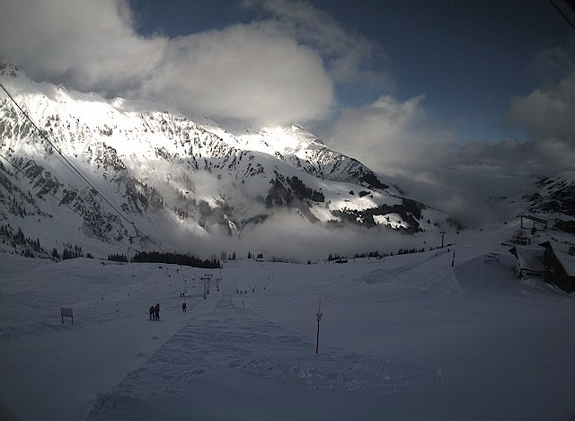
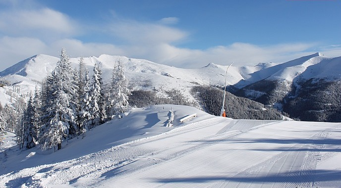
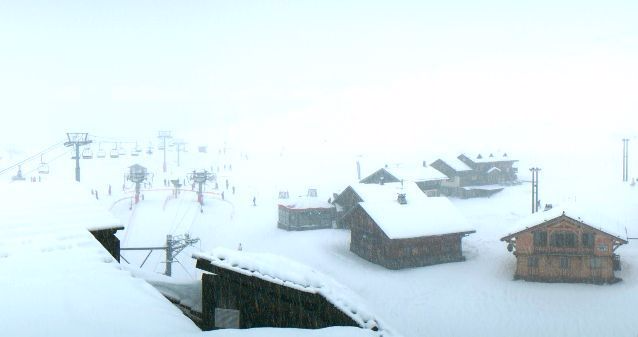
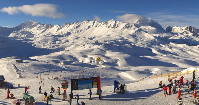
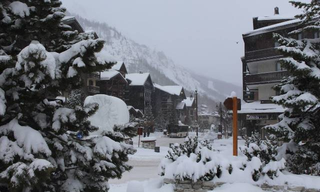
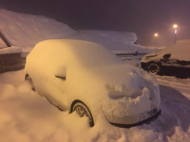
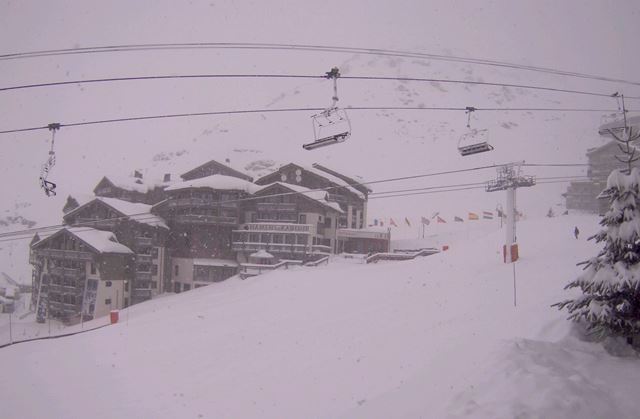 Heavy snow this morning in Val Thorens - Photo: valthorens.com
The rain/snow limit is highly variable right now, but is (roughly speaking) sitting at between 1200m and 1600m in the north-western Alps, and between 600m and 1200m in the north-eastern Alps.
At altitude there has already been some significant snowfall overnight (30cm in Val d’Isère, for example) with plenty more to come today. It is turning warmer, however, which means that the snow will turn increasingly to rain below 2000m in the west as the day goes on (perhaps even 2200m this evening). Further east, the snow-line will remain lower, especially in the more internal valleys, but will still tend to rise.
Tonight, rain and snow will die away to leave a mostly fine but exceptionally mild day on Monday, with freezing levels in excess of 3500m in the west.
Snowfall totals from this storm will be impressive at altitude in the northern Alps, especially in northern France (e.g. Chamonix), and northern and western Switzerland (e.g. Verbier, Engelberg) where 40-70cm of new snow is forecast above 2300m, locally a bit more. Parts of Austria will also see significant snow, especially the north and west (e.g. St Anton), but the southern Alps will again miss most of the action.
Needless to say, avalanche danger will be very high in the northern Alps tomorrow, complicated by the unusually high freezing levels.
Looking a bit further ahead, it will cool down again mid-week with some further snow showers, mostly in the north.
Updated: 12.30pm Saturday 30 January 2016 - Major bad weather day in the north on Sunday!
After a relatively benign weather day on Saturday, active weather fronts will reach the north-western Alps tonight.
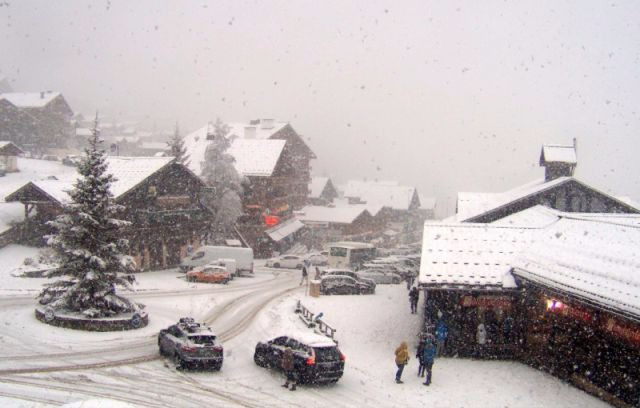
 High cloud spilling in from the north-west over Morzine - a prelude to the stormy weather expected tonight and tomorrow - Photo: morzine-avoriaz.com
This afternoon, high cloud is already spreading into the northern French and western Swiss Alps. This will continue to thicken, with the first precipitation due in the far north-west early this evening.
Tonight it will snow heavily in the northern French, northern and western Swiss Alps, and later in western Austria. The rain/snow limit will begin at around 1200m, but lower temporarily to 400-700m in the east, before rising again tomorrow morning.
The bad weather will continue on Sunday, with further heavy precipitation across most of the northern Alps. It will, however, become increasingly mild, with the rain/snow limit rising to 2000m or higher in the west later. Further east (i.e. Austria), it will remain low for a time before creeping up to between 1200m and 1600m by the end of the day.
Throughout this period the southern Alps will again miss the bulk of the precipitation, with just a few showers here and there. Snowfall totals from this storm will be highest in the north-western Alps - i.e. the northern French Alps (e.g. Chamonix), northern and western Swiss Alps (e.g. Verbier, Mürren) and far western Austrian Alps (e.g. St Anton). Above 2300m these areas could see 30-50cm of new (but windblown) snow, locally 60cm+. Lower down, however, rain will be a problem.
Monday will see a big improvement in the weather, but it will be exceptionally mild with freezing levels in excess of 3500m in the west!
Updated: 9.40am Friday 29 January 2016 - Still mild, big storm on Sunday
There has been a dusting of snow overnight across some northern parts of the Alps above 1600-1800m, but no more than that. A much more potent storm will hit the north-western Alps on Saturday night.
 Fine weather this morning in Lienz in the far south of Austria - Photo: foto-webcam.eu
The northern French and western Swiss Alps will be hit first, on Saturday night, before the bad weather spreads east to affect much of Switzerland and parts of Austria, notably the west, on Sunday.
The rain/snow limit will start between 1200m and 1500m on Saturday night, but rise towards 2000m later on Sunday, especially in the west. At 2500m we could see 40-60cm of new snow in some north-western parts of the Alps (e.g. Chamonix, Verbier), but it will be extremely wet and soggy lower down.
The higher resorts of eastern Switzerland (e.g. Laax) and western Austria (e.g. St Anton, Ischgl) should also see some significant snow at altitude, but the southern half of the Alps will again miss the bulk of the precipitation.
Looking a bit further ahead and, after a mostly fine but very mild day on Monday, it will cool down towards the middle of next week with a little snow in places, chiefly in the north.
Updated: 9.30am Thursday 28 January 2016 - Still mild, with a dusting of snow in north tonight
There’s another mild day in store for the Alps. Most places will be dry, but cloud will thicken later with a little rain/snow expected across the northern Alps tonight.
 Glorious start to the day in southern Austria. This is the Mölltal glacier - Photo: gletscher.co.at
The rain/snow limit will start at round 1500-1800m tonight, dropping to 1200m or lower later. However, snowfall totals are expected to be very modest, with just 1-5cm in the north and the southern Alps, again staying dry.
Expect variable snow conditions across the Alps today, with the best skiing at altitude and on-piste. Lower down, there is something of a freeze-thaw cycle in place, especially on the slopes more exposed the sun.
It will stay mild over the next few days, with some more significant rain/snow expected in the northern Alps on Sunday.
Updated: 9.20am Wednesday 27 January 2016 – Remaining very mild
The weather in the Alps is broadly similar to what we saw yesterday. Most areas are bright, but there is a lot of high cloud around, thickest in the north, with the best of the sunshine in the south. Temperatures are again way above average for January, with freezing levels close to 3000m.
 Still some snow, albeit of wet consistency, to low levels in the northern Austrian Alps. This is Pass Thurn near Kitzbühel - Photo: foto-webcam.eu
A very weak weather front will bring a few showers to the northern Alps tomorrow evening/night, with a dusting of snow at altitude, though not amounting to much.
The next precipitation of any note will be on Sunday, again mostly affecting the northern Alps. It will be mild, however, with a rain/snow limit between 1500m and 2000m.
So with the weather in the Alps as mild as it is, the best snow conditions are at altitude right now. Lower down, it will again feel a bit spring-like today with some slush on south-facing slopes by afternoon.
By contrast, it is still possible to find cold wintry snow on higher north-facing slopes, even some powder in the northern Alps - if you know where to look.
Updated: 9.15am Tuesday 26 January 2016 - Another exceptionally mild day
The weather in the Alps is exceptionally mild again today, with freezing levels close to 3000m. Most places will be sunny (above any valley fog patches), but there are some areas of high cloud drifting around, thickest across the northern Alps.
 Mostly bright but with some high cloud at times today in Gstaad - Photo: gstaad.ch
As for snow conditions, these have become more variable in the mild weather this week. At altitude the slopes are still generally in good condition, and there are pockets of powder to be found. Lower down, however, the snow has become spring-like in places, especially on slopes exposed to the sun.
It will stay on the mild side for the rest of the week. After a dry day on Wednesday, some weak weather fronts will bring a little snow to parts of the northern Alps on Thursday and Friday. The southern side of the Alps will again stay mostly dry.
Updated: 9.20am Monday 25 January 2016 - Mostly sunny, very mild
There was some new snow over the weekend, most of it falling on Saturday, and in Austria (5-20cm). However, it has now turned very mild in the Alps and temperatures will remain above normal all week. There isn’t much snow in the forecast either, but there will be plenty of sun.
 Beautiful day in the southern French Alps. This is Vars - Photo: vars.com
Today, some parts of Austria will start cloudy, but generally speaking we can expect lots of sunshine and exceptionally mild temperatures across the Alps, with freezing levels as high as 3300m in the west. This will make for some very pleasant skiing conditions for anyone lucky enough to be in the Alps at the moment, especially on-piste.
Off-piste there are still pockets of powder to be found, especially at altitude, and in the north and east. Generally speaking, however, the rise in temperature means that snow conditions off the beaten track are more variable, especially lower down and on slopes exposed to the sun.
Updated: 10.40am Sunday 24 January 2016 - Mostly fine and increasingly mild
High cloud is affecting some northern parts of the Alps today, especially in northern Austria. Elsewhere there is plenty of sunshine, particularly in the inner Alpine valleys and across the south.
 Great piste skiing at altitude in Ischgl - Photo: ischgl.com
We are now entering a much milder spell of weather in the Alps, which will last all of this week and probably beyond. There will be plenty more sunshine, but weather fronts will never be far from the northern Alps, with Thursday the most likely day to see some showers. We do not, however, expect any significant or widespread snowfall any time soon.
Updated: 11am Saturday 23 January 2016 - A little new snow, mostly in the north-eastern Alps
A weak weather front skirted the northern Alps last night, bringing a dusting of snow in places but also a little rain lower down.
 Brightening up in Adelboden this morning after a cloudy start - Photo: adelboden.ch
The heaviest snow (5-15cm) was in the Austrian Alps, where it is still snowing this morning (away from the far south). Further west, however, it is brightening up and this brighter weather will extend to most regions as the day progresses. The best of any sunshine will again be in the southern Alps, especially the south-west, where there has been little if any precipitation.
So with this more humid and relatively mild air in place over the Alps, snow conditions are not quite as fabulous now as they were for much of the past week. However, there is still lots of good skiing to be had, particularly at altitude. There is even a little powder in places this morning, mostly in the north-eastern quarter of the Alps.
Updated: 9.35am Friday 22 January 2016 - Glorious!
The weather will be glorious in the Alps today, with (almost) wall to wall sunshine, spoilt only by some high cloud drifting into north-western regions later in the afternoon.
 A glorious morning in La Rosière, though high cloud will drift in from the north-west later - Photo: winter.larosiere.net
After a very cold start, it will feel quite pleasant in the sunshine, with freezing levels close to 2000m in the west, but lower in the east. This evening, a few light showers (snow 1500m) will reach the north-western Alps, spreading further east overnight.
On Saturday these showers will transfer into Austria, while the north-western Alps brighten up. Generally speaking, snowfall totals will be modest (2-10cm), but 20cm+ is possible in some parts of Austria, especially at altitude and to the east of Innsbruck. The rain/snow limit will be around 1500m in the west, but starting as low as 700m in the east before rising to 1200m or more.
Sunday should see most of the showers die away from the eastern Alps, but it may stay rather cloudy. Further west, it should be brighter with relatively mild temperatures across the board. Throughout the weekend, the southern Alps will again stay mostly dry.
So, after a fabulous day right across the Alps today, snow conditions will become a little more variable over the weekend, with the introduction of milder, more humid air, especially across the northern Alps. Don’t expect a huge amount of new snow, but some powder is possible at altitude, especially in Austria later on Saturday, and early Sunday.
It will continue relatively mild for much of next week, with weather fronts never far away from the northern Alps.
 Unbroken sunshine expected today in the Austrian Vorarlberg. This is Damüls - Photo - damuels.at
Updated: 9.25am Thursday 21 January 2016 - Some cloud in the far east of the Alps, otherwise mostly sunny
There are still areas of cloud affecting some eastern parts of the Alps this morning, and even a light flurry here and there in northern Austria. However, for the vast majority of the Alps it is sunny (at least at altitude,) and these sunnier skies should reach most areas as the day progresses.
 Cloud clearing to reveal a magnificent day in the Austrian Bregenzerwald. This is Mellau - Photo: damuels-mellau.at
It will remain relatively cold, especially in the east, but the trend is for temperatures to continue to rise and it should feel quite pleasant in any sunshine.
Tomorrow (Friday) looks like being a glorious day right across the Alps, with lots of sunshine and excellent skiing conditions across the board.
Snow conditions remain excellent across the northern half of the Alps with plenty of powder still to be found if you know where to look, though note that the risk of avalanche remains considerable.
In the southern Alps, with the exception of parts of France and the far north-west of Italy (e.g. Courmayeur), cover is still thin and you are more or less obliged to stick to the pistes.
After a magnificent weather day tomorrow, it will turn unsettled again over the weekend. However, with milder air in the mix, the rain/snow limit may rise to 1500m or higher in the western Alps for a while. Tune in for further details tomorrow…
Updated: 9.30am Wednesday 20 January 2016 - A few light flurries but many places brightening up
There is still quite a lot of cloud across the northern Alps this morning, even one or two light snow flurries (400-600m) in places, chiefly in northern Switzerland and Austria. These flurries will become increasingly confined to the north-eastern Alps as the day goes on.
 Still cloudy with a few snow flurries in the Austrian Arlberg this morning. This is Zürs - Photo: lech-zuers.at
Elsewhere in the Alps, it will tend to brighten up (if it hasn’t already) with the best of the sunshine in the south-west. Tomorrow and Friday, high pressure will dominate with lots of sunshine and increasingly mild temperatures.
Over the weekend, a new weather front will bring further snow to some parts of the Alps, but there is still uncertainty over the detail. As things stand, the eastern Alps will probably see the heaviest precipitation (notably Austria) but, with milder air in the mix, there may also be some rain low down.
As for current snow conditions in the Alps, they are excellent across the northern half of the chain, though note that avalanche danger remains high off-piste.
In the southern Alps, snow cover is still (with one or two exceptions) very thin for January. For now there is some enjoyable piste skiing to be had, but significant snow is still needed in order to alleviate concerns later in the season. The major exception to this rule is the far north-west of Italy, where the likes of Courmayeur, La Thuile and Cervinia have plenty of snow for now.
Looking a bit further ahead into next week, and it does look like high pressure will be the dominant theme, with lots of dry fine and relatively (but probably not excessively) mild weather across the Alps.
 Brighter skies in the southern Austrian Alps. This is Bad Kleinkirchheim - Photo: badkleinkirchheim.at
Updated: 9.45am Tuesday 19 January 2016 - Still cold, light flurries in the north-western Alps
Yesterday was a near perfect ski day in the north-eastern Alps, with blue skies, deep snow and frigid temperatures. Conditions were pretty good in the north-west too, but here cloud increased during the day to bring a little snow to the French and western Swiss Alps by evening.
 View towards Innsbruck and the Nordkette this morning - Photo: foto-webcam.eu
This morning, many western parts of the Alps have woken up to at least a dusting of snow, with 5-15cm across the far northern French Alps (15cm of fresh in Avoriaz, for example). With the cold temperatures, this snow has fallen very low levels and is again light and powdery in consistency.
This morning, a scattering of light snow showers are still affecting the northern French, northern and western Swiss Alps. These will move slowly east to reach western Austria tonight, then perhaps some other parts of Austria tomorrow, but accumulations will remain modest. The southern Alps will again stay mostly dry with sunny spells.
Further light snow flurries will affect some parts of the Alps mid-week, mostly in the north, before it turns drier and milder everywhere towards the weekend.
Updated: 9.30am Monday 18 January 2016 - Deep snow and deep blue skies in the north-eastern Alps
It snowed virtually non-stop across some northern and north-eastern parts of the Alps this weekend. This morning, however, skies have cleared to reveal a veritable winter wonderland.
 Cold powder snow at all levels in northern and western Austria this morning. This is Pass Thurn near Kitzbühel - Photo: foto-webcam.eu
We have seen close to one metre of new now in the last two to three days in parts of the north-eastern Swiss Alps, as well as the Austrian Vorarlberg and Salzburgland. Other northern parts of the Alps also have a thick layer of snow but, protected by the “north Foehn”, the southern Alps have again missed most of the action.
Unlike most storms this season, low temperatures mean that the snow has fallen at all levels and is “cold” and “light” in consistency. In short, it’s a dream to ski on, but avalanche danger remains sky high off-piste.
To give you an idea of just how cold it is in the Alps right now, it went down to -18°C in Val d’Isère last night, - 24°C at Samedan near St Moritz and -34°C in the famous “frost hollow” of Glattalp in the Swiss canton of Schwyz!
Today, the weather will remain beautiful across the eastern Alps all day. However, cloud will thicken up in the west as the day goes on with a few snow flurries later. These flurries will move further east overnight and into tomorrow, but are not expected to amount to very much.
Looking a bit further ahead and, generally speaking, we are in for a quieter week in the Alps. There will be some further snow flurries at times, mostly in the north during the middle part of the week, but they are not expected to be particularly significant. Further south, it will again stay mostly dry.
As for temperatures, after a cold start, the weather in the Alps will become a little milder later in the week.
 Fabulous conditions in Avoriaz this morning, but cloud will thicken again from the west as the day goes on - Photo: avoriaz.com
Updated: 12.15pm Sunday 17 January 2016 - Bitterly cold, further snow showers across northern Alps
There has been lots of new snow in the northern Alps this weekend, with snow showers continuing today, heaviest in Austria and eastern Switzerland. Protected by the “north Foehn”, the southern Alps remain mostly dry with variable cloud, and just the odd flurry.
 Serious snow in Lech this weekend - Photo: lech-zuers.at
The heaviest snowfalls have been in the north-eastern Swiss Alps (e.g. Braunwald, Amden) and the Austrian Vorarlberg (e.g. Warth, Damüls), where we have seen 40-60cm in the last 24 hours alone!
Many other parts of Switzerland and Austria (away from the south) have also seen significant snow, as have the far northern French Alps, especially the Haute-Savoie. With very low temperatures, the snow is light and powdery in consistency and has been falling at all altitudes. However, avalanche danger remains sky high, which has been exacerbated by the strong northerly wind.
Updated: 10.50am Saturday 16 January 2016 - Further snow showers for the northern Alps
The southern and western Alps saw plenty of sunshine yesterday. However, snow flurries soon returned to the north and west of Austria, spreading to other northern parts of the Alps in the evening and lingering overnight.
 Fabulous looking snow conditions in the Haute-Savoie right now. This is La Giettaz near Megève - Photo: valdarly-mtblanc.com
These snow showers have delivered between 5cm and 20cm quite widely across the northern Alps in the last 24 hours, with up to 30cm in a few favoured spots. The snow also fell to very low levels - there was 4cm on the ground this morning in Chambéry, for example.
Today, snow showers will continue to affect some northern parts of the Alps, notably Austria and eastern Switzerland where another 10-30cm is possible. Snow flurries will be a bit lighter and more scattered in the western Swiss and northern French Alps. The southern side of the Alps will again be mostly dry with sunny spells, but it will be bitterly cold everywhere.
There will be little change in the weather tomorrow (Sunday). It will remain bitterly cold everywhere with further snow showers for the northern Alps, but with a marked emphasis towards the north-east. The south will remain mostly sunny. Most other parts of the Alps will also brighten up on Monday.
So snow conditions are potentially fabulous right now across many northern and western parts of the Alps, with light “dry” powder down to very low altitudes. Please note, however, that the risk of avalanche remains very high off-piste.
 Lots of fresh snow for the Austrian Arlberg this weekend. This is Zürs - Photo: lech-zuers.at
Updated: 9.20am Friday 15 January 2016 - Cold, further snow showers, mostly in the north
There has been more snow in the Alps in the last 24 hours, mostly in the north, with 10-20cm falling quite widely, and 30cm+ in a few favoured spots such as the Swiss Vaud (Les Diablerets). Some western Italian resorts also saw some snow, but much of the southern Alps stayed dry.
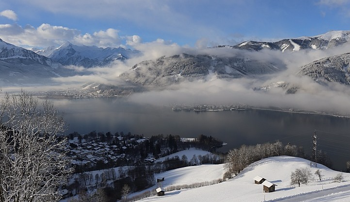 Picture postcard winter scene this morning in Zell-am-See - Photo: foto-webcam.eu
Today, we will again see plenty of sunshine on the southern flanks of the Alps. Further north, there will be more in the way of cloud, with occasional snow showers becoming heavier and more frequent later in the day and extending into the night. It will also be cold, with any snow falling to very low levels.
Over the weekend yet more snow is expected across the northern Alps, heaviest this time in the north-east - that is to say the eastern Swiss Alps and much of Austria. The southern Alps will again miss most of the action, but it will be very cold everywhere.
Snow conditions are potentially superb across much of the northern Alps, especially the north-west, with cold powdery snow down to low levels. However, with avalanche danger still sky high, the authorities are still urging the utmost caution.
With some breaks around in the cloud this morning, it will be more tempting than ever to get off the beaten track, but don’t even consider going off-piste without a good guide unless you know exactly what you are doing.
Updated: 9.20am Thursday 14 January 2016 - Cold, more snow for the west
Yesterday the sun finally made an appearance in the western Alps, where snow conditions were the best they have been all season. However, we were also served a stark reminder of how dangerous it is off-piste right now, with a number of avalanche incidents, including the tragically fatal incident in Les 2 Alpes.
 Snowing again today in the western Alps. This is Méribel - Photo: meribel.net
Ironically, Les 2 Alpes has not actually had a huge amount of snow, at least compared with ski resorts further north. It has been very windy though, and although it is too early to speculate on the key factors in this particularly case, wind slabs (in conjunction with the weak base laid down earlier in the season) are a particular worry right now.
The high avalanche danger isn’t going to go away anytime soon either, with further snow expected across the western Alps today, and across the northern Alps tomorrow and over the weekend.
Quickly looking back at yesterday, the sun finally came out in the western Alps in the afternoon to reveal a veritable winter wonderland. By contrast, snow showers continued to low levels in the north-eastern Swiss, northern and western Austrian Alps for much of the day, generally depositing between 5cm and 20cm of new snow, locally a bit more.
Today it will be the eastern Alps that will stay mostly dry while a new storm brings snow to the western Alps, this will be heaviest in the French Alps where we are expecting another 15-25cm. Parts of Switzerland (especially the west) and western Italy (e.g. Courmayeur) will also see a moderate fall but, generally speaking, the further east you are, the lighter and patchier it will be.
As we move into tomorrow and the weekend, the focus of the snow will be more on the northern Alps, with France, Switzerland and Austria all equally in the frame for further top-ups. It will turn colder still, with any snow falling to very low levels.
For more on snow conditions in the Alps check out our latest snow report updated later today...
 The best of the weather will be in the eastern Alps today. This is Heiligenblut in Austria - Photo: foto-webcam.eu
Updated: 9.40am Wednesday 13 January 2016 – Cold with further snow, mostly in the north-eastern Alps
There has been lots more snow across the north-western Alps in the last 24 hours. It has also turned much colder, which means that any snow is now falling at all (skiing) levels.
 Serious snowfall totals in Val Thorens! - Photo: facebook.com/valthorens.resort
Many other parts of the Alps have also seen at least a little snow, but the northern French and western Swiss Alps are where it has been falling in eye-catching quantities.
These regions have quite widely seen between 50cm and 80cm of windblown new snow above 1800m, this week alone. Some areas, notably the far north and west of the Swiss Valais, have even seen as much as 150cm! Now that it has turned colder, snow has also been falling to low altitudes, which means the ground is now white as low as 500m in places.
Snow has been falling in many other northern parts of the Alps, though generally in more modest quantities. The south saw a little snow earlier in the week, but brightened up yesterday with some good spells of sunshine.
 Brightening up after heavy snowfall in Les Saisies - Photo: Les Saisies.com
Tomorrow, the eastern Alps will see the best of the weather, while yet more snow returns to the west. Snow showers will continue on Friday and into the weekend, affecting mostly the northern half of the Alps, where they will fall to low altitude.
Please note that avalanche danger remains high in many parts of the Alps, and very high in the north-west where there has been so much wind and snow in recent days. Check the daily bulletins, stay informed, and don’t even think about going off the beaten track unless you know exactly what you are doing or are with a fully qualified guide!
Next week the jury is still out. Some weather models suggest that it will gradually turn milder after a very cold start to the week. Others indicate that the cold will hang on for longer. We will have more on this in our daily updates as the week goes on…
Updated: 9.30am Tuesday 12 January 2016 - Colder, lots more snow for the north-western Alps
Yesterday was a very challenging weather day in the Alps with rain, snow and high winds affecting many resorts.
 Lots of new snow in western Switzerland. This is Zinal in the Val d’Anniviers - Photo: valdanniviers.ch
The heaviest snow was again in the north-west, where above 2000m we have seen 25-50cm of new snow quite widely in the last 24 hours alone. Snowiest of all seems to have been western Switzerland, with 75cm recorded on the Glacier de Saleina (2972m) as well at Trübelboden (2480m) near Leukerbad.
Below about 1800m, however, Monday saw some rain for a time, especially in the French Alps, before the colder air finally dug in later in the day.
Elsewhere in the Alps (away from the French and western Swiss Alps) snowfall totals were generally more modest, with 5-30cm more typical. Two notable exceptions, however, were the far north-west of Italy (e.g. Courmayeur, Cervinia) and the eastern Tirolean Tauern region in Austria, both of which saw 40cm+.
 Fresh snow and blue skies this morning in Bad Kleinkirchheim in southern Austria - Photo: badkleinkirchheim.at
Today, the focus of the snow is back on the north-western Alps with another 20-40cm expected to fall quite widely across the northern French Alps, much of Switzerland (away from the far south) and the far west of Austria. It’s also much colder, which means that any snow will fall between 600-900m, lower still later in the day and overnight.
Tomorrow (Wednesday) will see something of a reprieve, with some sunny spells developing, especially in the inner Alpine valleys and to the south. A big word of caution, however. Conditions will look fabulous, but the off-piste will remain highly dangerous, especially in the north-western Alps where so much new snow has fallen.
More snow is then expected later in the week, mostly in the north where it will fall to low altitudes.
Updated: 9.45am Monday 11 January 2016 - Big weather day for the Alps!
There’s a serious mix of weather out there in the Alps today, with snow, rain, and high winds. Some places will stay dry, but without much in the way of sunshine.
 Heavy snow and high winds in Val Thorens this morning - Photo: valthorens.com
The rain/snow limit is highest this morning in the French Alps - still 1800m at the time of writing in some parts of Haute-Savoie (e.g. Avoriaz). By contrast, not very far away on the Italian side of Mt Blanc, it is closer to 1200m.
These differences over a relatively short distance make generalising about snowfall totals today extremely tricky. What we do know for sure is that the temperature will drop as the day goes on, with snow falling to 1000m or lower later in the day, even in the western Alps. Further east, the snow-line is already somewhere between 1000-1500m, and will also fall steadily.
Expect a lot more snow at altitude in the western Alps today (there has already been plenty over the weekend), with 30-50cm likely above 2000m. There will also be some useful accumulations lower down later in the day and overnight - good news for rain ravaged Morzine, Megève and other low-lying resorts, which have seen much of their lower base washed away in recent days.
 Snow falling to relatively low levels in the Aosta valley this morning. This is Champoluc - Photo: monterosa-ski.com
So the heaviest snow will be in the western Alps this morning, but will spread east during the day. Unlikely many storms this season, the majority of Italian resorts will also see a useful fall of snow. This will be heaviest in the Aosta region (e.g. Courmayeur), but Lombardy and the western Dolomites could also see some decent action. The areas likely to see the least snow today are the northern and eastern Austrian Alps (Salzburgland and Upper Austria).
On Tuesday, most of the snow will revert to the north-western half of the Alps, where it will fall to between 500m and 900m. This snow should slowly die away during Wednesday, but more snow is coming on Thursday and Friday, heaviest in the north.
So all in all, prospects for the Alps are good, even if we have some tricky weather conditions to negotiate over the next few days. Note that the avalanche danger is high in many regions, and very high in the north-western Alps, where the situation has the potential to become very serious in places.
Updated: 9.05am Sunday 10 January 2016 - An exceptionally snow week on its way for some!
The weather in the Alps remains very unsettled, with lots more snow expected over the next few days, heaviest again in the north-west but also getting through further south and east at times.
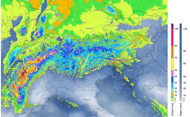 Predicted snowfall over the next five days with the north-western Alps again bagging the lion’s share - Image: bergfex.com
Yesterday was a mostly cloudy day across the Alps, with some places staying dry. However, there was further snow in places, particularly across the western Alps (France, western Switzerland and the far north-west of Italy), but notably also across some central and eastern parts of the Italian Alps, pushing into the far south-east of Switzerland and the south of Austria - something we haven’t seen too much of this season so far.
Yesterday’s rain/snow limit was highly variable, but could often be found between 1300m and 1900m, so it wasn’t particularly cold, and some low resorts (e.g. Morzine) have been badly affected by rain.
Today, further snow showers will mostly affect the western Alps (snow 1200-1600m), with lighter, more sporadic precipitation further east. Then tonight, more active weather fronts will move in from the west, which will deliver heavier, more widespread snow across the Alps on Monday, continuing in places on Tuesday and Wednesday. There will also be some rain - up to 1600m for a time in the west on Monday - before it turns cooler everywhere from Monday night onwards.
 Looking better in the Dolomites now than it did just a couple of weeks ago, but more snow would still be welcome. This is Canazei - Photo: visittrentino.it
The second half of next week will remain on the cold side with further snowfall likely in places, heaviest in the northern Alps.
Over the next five to six days, the biggest snowfall totals will again be reserved for the north-western half of the Alps with 1-1.5m possible above 1800m in places, locally more! However, many southern parts of the Alps will also see some useful snow, especially on Monday.
Be warned though - the risk of avalanche, which is already high in some areas, will become critical in the north-western Alps, perhaps even reaching the maximum 5/5 in places mid-week. We will have more on this potentially severe spell of weather in our update tomorrow…
Updated: 3.50pm Saturday 9 January 2016 - Mostly cloudy with rain and snow in places, heaviest in the west
The weather situation remains complicated with a slow moving warm front lying across the north-western Alps today. This is delivering plenty more snow at altitude, particularly in the French Alps, but also parts of Switzerland and the far north-west of Italy. Lower down, however, there has been some rain.
 Heavy snow in Avoriaz today - Photo: avoriaz.com
The heaviest of today’s snow is in the French Alps where the rain/snow limit is situated around 1400-1800m. Further east, the snow-line is a fraction lower. For the likes of Morzine, Megève and La Clusaz, the rain is causing problems, washing away much of the (meagre) snow cover below 1500m. Above 2000m, however, the snow is really piling up and will continue to do so over the next few days.
Most other parts of the Alps are cloudy today, with some rain/snow (1400-1700m) here and there, but not generally as significant as in the west.
The very unsettled weather will continue tomorrow and into next week with colder air arriving later on Monday.
Broadly speaking, the western Alps will again see the highest snowfall totals over the next few days, very high in places, but the southern Alps will also get a look in, especially on Monday. The area likely to see the least snow is the eastern Austrian Alps, but there is still lots of volatility in the weather models, so this could change.
One thing we can be sure of is that the avalanche danger off-piste is high, especially (but not exclusively) across the north-western Alps, and will increase further next week. Indeed the situation could become critical in places, so be extra vigilant and stay tuned to local bulletins.
Updated: 9.30am Friday 8 January 2016 - Lots of new snow in places, but milder
Thursday was a very snowy day across the north-western Alps, though with the arrival of milder Atlantic air, it did turn to rain as high as 1800m in places later.
 Big snowfall in Val Thorens yesterday - Photo: facebook.com/ValThorens.resort
In the more enclosed valleys where the cold air hung on for longest, it snowed at low altitude for much of the day, but even here the warmer air eventually won out. The next few days, generally speaking, will also be relatively mild.
Yesterday’s snowfall totals were quite significant in the French Alps - 20-40cm above 1800m for most, locally a bit more. Unlike many storms this winter, the southern French Alps (away from the far south) also saw a useful fall of snow.
The Swiss Alps saw 15-25cm of new snow in the west yesterday, with more like 5-15cm in the east of the country and in western Austria. Elsewhere in the Alps, including most of the south, there was little if any snow.
Today, a new wave of precipitation will reach the western Alps, again heaviest in France but with an elevated rain/snow limit of around 1800m. Except for the odd shower, the eastern and southern Alps will be dry with variable cloud and even a little sunshine in places.
It will continue unsettled but relatively mild over the weekend, with further showers and some snow at altitude here and there. It will then turn colder next week with the prospect of heavier snow to lower levels, especially in the north and west.
Updated: 9.25am Thursday 7 January 2016 - New storm, but highly variable snow-line
We have a complicated weather day coming up in the Alps, as a warm front moves in from the west bringing further heavy snow (but also some rain) to northern and western regions in particular.
 Snowing again in Avoriaz this morning, but it may turn to rain later - Photo: avoriaz.com
Briefly recapping on yesterday’s weather, and we saw further snowfall in places, chiefly in the northern French Alps (e.g. Portes du Soleil), and northern and western Swiss Alps (e.g. Villars), with 2-10cm (and locally 15cm) falling to relatively low altitudes.
Today, there will be a lot more snow, but the rain/snow limit is extremely difficult to forecast. Why? Because we have a warm front from the Atlantic bumping into the relatively cold air in situ over the Alps. Warm air rises and cold air sinks, so the tendency in this situation is for the milder air to rise over the colder air, at least in the first instance.
In the western foothills, it won’t take long for the warmer air to “win out”, but the deeper you go into the Alps, the greater difficulty it will have in dislodging the reservoirs of cold air, which linger longer in the more enclosed valleys.
 Snowing in Méribel this morning, but it will turn to rain later - Photo: merinet.com
So early this morning, we expect the rain/snow limit to be around 700-1000m close to the north-western edge of the Alps, but rising quickly to reach 1600-1800m (possibly higher) later in the day. In the more enclosed valleys, such as the Val d’Anniviers in Switzerland, it may snow at very low levels for an extended period, before eventually rising to 1200-1500m later.
To recap then, the further east and “enclosed” you are, the longer it will snow to low altitudes. The more exposed you are to the west/north-west, the quicker it will turn to rain, though above about 1800-2000m it should remain as snow everywhere.
Above 2000m we could see another 20-40cm of snow in the northern French Alps today, locally a bit more. The northern and western Swiss Alps (e.g. Verbier, Engelberg), the far west of Austria (e.g. Lech) and the far north-west of Italy (e.g. La Thuile) could also see a decent dump, but most other regions will see little if any precipitation.
Friday will be mild with further showers, mostly in the west with a relatively elevated rain/snow limit of between 1400m and 2000m. It will stay unsettled through the weekend, but turn colder later, with further showers in many places (even in the south for a time). More on this in our weekend snow forecast tomorrow...
Updated: 9.20am Wednesday 6 January 2016 - More snow in the forecast, but much milder at the end of the week
The sun came out for a while in the snowy north-western Alps yesterday, making it one the best skiing days of the season so far. However, there was also a stark reminder of how perilous the off-piste has become, with two avalanche incidents in Val d’Isère alone, one of which was tragically fatal.
 View from Les Arcs this morning with snow down to Bourg St Maurice in the valley - Photo: lesarcs.com
Since the beginning of this storm cycle we have seen around 40-80cm of snow above 1800m in the north-western Alps generally, and over 100cm in the northern French Alps locally (Bauges, Beaufortin and parts of the Massif de Mt Blanc).
Further south and east, snowfall totals have generally been modest, with the exception of the far west of Austria (e.g. Lech) and some western/north-western parts of Italy (e.g. La Thuile), where we have seen around 30-50cm of new snow.
More snow is expected later today, mostly in the northern French, and northern and western Swiss Alps, but also extending east into some parts of western Austria. Snowfall quantities will remain quite modest (5-10cm generally), but the rain/snow limit will remain quite low, at between 600m and 900m. Except for a few flurries close to the border regions, the Italian Alps will miss most of the showers, with many places staying dry.
 Looking great in Val d’Isère this morning with lots more snow forecast over the next few days - Photo: valdisère.com
Tomorrow (Thursday), more active fronts will spread into the western Alps. These will bring heavier precipitation, but also much milder air that will linger through Friday and into the weekend. Expect a lot of snow at altitude in the northern French and western Alps, and also lower down for a time, especially in the more internal valleys.
Later on Thursday and particularly on Friday, the rain/snow limit could reach 1800m or more in some exposed western resorts. We will have more detail on this complicated situation in our update tomorrow.
Looking further ahead and the weather in the Alps will remain very unsettled for the foreseeable future. It will remain relatively mild over the weekend, but will turn much colder next week with snow returning to very low levels.
The western Alps again look favourite to see the greatest quantities of snow, but most other areas will get a least a look in over the next week or so.
Updated: 10.10am Tuesday 5 January 2016 - Snow piling up in the north-west
In some parts of the Alps, notably the north-west, the snow is really starting to pile up. In others, notably the south and east, it’s still a case of bits and pieces here and there.
 Another snowy night in Val d’Isère (20cm fresh) - Photo: radiovaldisere.com
In the last 24 hours we have seen another 10-30cm of new snow above 1800m in the northern French and western Swiss Alps, very locally 40cm. Once again though, the further east and south you go, the lighter and patchier any snowfall has been.
In the last three days we have now seen 40-80cm of new snow above 1800m in the north-western Alps (e.g. L’Espace Killy, Paradiski, 3 Valleys, Mt Blanc region, Portes du Soleil, Verbier), locally 100cm in parts of France. In the central and northern Swiss Alps (e.g. Mürren, Engelberg, Davos), as well as the far west of Austria (e.g. Lech), we have seen between 25 and 50cm.
For the rest of Austria, most of Italy (away from the far north-west) and the southern quarter of the French Alps it has been more like 5-20cm, though there have, of course, been exceptions to this rule.
The weather will continue unsettled for the rest of the week with further Atlantic weather fronts piling in from the west. This means that it will be the western areas that will again see the heaviest precipitation, with further significant snowfall, especially at altitude.
So far this week the rain/snow limit has been relatively low, somewhere between 600m and 1400m. This is likely to rise later in the week, with rain possible as high as 1800m in the western Alps for a time. However, it does look like it might turn much colder next week, with snow returning to very low levels.
For current snow conditions in the Alps, see yesterday’s snow report.
 Still not cold enough for a decent base at low altitude in the French Alps. This is Morzine - Photo: chilloutmountain.com
Updated: 10am Monday 4 January 2016 - Serious snow at altitude in the western Alps
The second major storm of this cycle reached the western Alps yesterday evening, before spreading further east overnight. The heaviest snow was in the northern French Alps and far western Swiss Alps where, above 1800m, there has been 25-40cm (very locally 50cm) of snow in the last 12 to 14 hours alone!
 Further heavy snow in the western Swiss Alps. This is Zinal - Photo: valdanniviers.ch
The rain/snow limit has varied from around 1400m in the most exposed foothills of the north-west to under 1000m further east, and as low as 500-600m in some of the more enclosed valleys. This latest storm has also brought some snow to eastern Switzerland, the far west of Austria and western Italy, though generally in more modest quantities.
The rest of Austria and the central and eastern Italian Alps (Dolomites) have seen very little this time round, but they still look more wintry thanks to the snow that fell on Saturday.
 30cm of new snow in Val d’Isère last night - Photo: valdisere.com
Today will see further snow showers, heaviest again in the northern French, western Swiss and extreme north-western Italian Alps. The best chance of any drier, brighter interludes will be on the southern edge of the Alps.
Snow conditions in the Alps have clearly been transformed over the last couple of days, especially in the west, where we have seen the biggest dumps. However, just about everywhere has now seen at least few centimetres, even in the southern Alps where some places hadn’t had any precipitation at all since October!
A note of caution though - avalanche danger has increased markedly in most areas and is particularly high in the northern French and western Swiss Alps. With the previously thin or non-existent snow-base, there are also still lots of hidden obstacles off-piste.
For the rest of the week, the weather in the Alps will remain unsettled with the heaviest snowfall always likely in the west. It does, however, look like it will turn much milder for a time later in the week, with the rain/snow limit rising to 1800m in some exposed parts of the French Alps as well as northern and western Switzerland.
 25cm of new snow in Val Thorens last night - Photo: valthorens.com
Updated: 9am Sunday 3 January 2015 - Relative lull, more snow in the west tonight
The first significant snow of this much anticipated storm cycle arrived yesterday, first affecting the French Alps, before moving east across Switzerland, parts of Italy and eventually Austria.
 That’s much more like it! Fresh snow and blue skies in La Plagne this morning - Photo: facebook.com/Laplagne
Snowfall totals rarely go completely to plan and, while there was not as much snow as initially forecast across the French Alps, some parts of Austria and Italy did better than expected. We are happy to report 25cm of new snow in the Arlberg region for example (e.g. Lech, St Anton) and around 10-15cm across much of the Tirol, although amounts do decrease steadily as you head towards the southern and eastern Austrian Alps.
The far west of Austria saw similar snowfall to the northern French Alps where, above 2000m, some 15-25cm of new snow is reported, very locally 30cm. Most southern French resorts also saw a useful snowfall, although generally not as much.
 25cm of new snow in Zürs this morning - Photo: lech-zurs.at
All of the Swiss Alps saw snow, with the greatest quantities in the far west (e.g. Les Diablerets, Portes du Soleil) and the far east (Flumserberg), where around 20cm was reported at altitude. In between (central Switzerland) there was somewhat less.
Snowfall was more hit and miss in Italy, but the Dolomites finally got a few centimetres, with some more substantial accumulations in the far north-west (e.g. La Thuile, Courmayeur).
In the western Alps, the rain/snow limit began at around 1400-1700m before lowering towards 1000m later in the day. In the eastern Alps, it was slightly lower and has reached 600m in places this morning.
Today, there are still some snow showers in the eastern Alps (600-800m), but most places will see some brighter weather before the next Atlantic storm reaches the western Alps tonight. This new storm will then move further east tomorrow (snow 1000-1400m), with the heaviest falls always in the northern French and western Swiss Alps, where there will be significant accumulations at altitude. The southern Alps will only see patchy snowfall.
The weather in the Alps will remain unsettled all week with the heaviest precipitation always in the west. The rain/snow limit will generally be around 800-1400m, but could temporarily reach 1800m in places later in the week with the arrival of a warm front. Some drier, brighter interludes are also likely, with the best of any sunshine in the southern Alps.
 Respectable snowfall in Val Thorens - Photo: facebook.com/ValThorens.resort
Updated: 10.30am Saturday 2 January 2015 - Heavy snow for the western Alps
And we’re off! It is snowing across many western parts of the Alps this morning with a rain/snow limit around 1300-1500m which will lower steadily as the day progresses.
 Heavy snow in Les Saisies this morning - Photo: lessaisies.com
The heaviest snow today will be in the northern French Alps (e.g. Val d’Isère, La Plagne, Chamonix, Avoriaz) where, above 1800m, between 20cm and 30cm is expected, with 40cm+ in one or two favoured spots.
The west of Switzerland (e.g. Verbier) and far north-west of Italy (e.g. Courmayeur) will also do quite well but, generally speaking, the further east you are the less significant the snow will become. We are only expecting a few centimetres from this storm in the eastern Swiss Alps and far west of Austria later today, and next to nothing in the eastern Austrian and eastern Italian Alps.
After something of a reprieve during the day on Sunday, the next Atlantic storm will reach the western Alps on Sunday night, bringing more heavy snow to the northern French and western Swiss Alps in particular.
Next week will remain very unsettled with further snow for many, with the western Alps always in line for the heaviest snowfalls. The rain/snow limit will be quite low at the start of the week - typically around 800-1100m - but could become more volatile later, with the risk of some rain at low altitudes.
Over the next five days or so, generally speaking, the resorts that are higher and further west are likely to see the most snow, with the northern French Alps (in particular) hitting the jackpot. Here we are expecting over 1m of new snow at altitude in many parts, and locally 1.5m.
The western Swiss Alps will also do well with perhaps 70-100cm above 1800m. The far north-western Italian Alps (e.g. Courmayeur, La Thuile), as well as the Austrian Arlberg (e.g. Lech), should also see some significant snow. While the further east and south you go, the less snow will fall.
 A sight for sore eyes! Snow falling in Val d’Isère - Photo: valdinet.com
Update: 11.30am Friday 1 January 2016 - First dusting of snow from new storm cycle
There is a dusting of new snow across some parts of the Alps this morning, mostly in the north, where 1-5cm has fallen above 1400m, very locally a bit more. The first significant snowfall from the much anticipated storm cycle will arrive on Saturday, however, primarily affecting the western Alps.
 Evidence of a little new snow above Kaprun this morning - Photo: foto-webcam.eu
There are still a few showers (snow 700m) across the eastern Austrian Alps this morning, though these will die away and the majority of Alps will see plenty of sunshine.
Tomorrow, the western Alps will see snow, especially the French Alps where 20-40cm is possible in places above 1800m. This snow will also affect much of Switzerland and, later, western Austria, but will become less significant the further east you are. Italian resorts (on the whole) are also only expected so see modest snowfalls (1-15cm). The rain/snow limit will start at around 1600m in the west, lower in the east and lowering generally to 1000-1200m later in the day.
After something of a lull on Sunday, Atlantic fronts will start piling in on Sunday night and affect the weather in the Alps for much of next week. We can therefore expect a lot of snow in the western Alps over the next seven days, with the high French resorts of the Savoie and Haute-Savoie hitting the jackpot. Some models calculate 1.5-2m of new snow at altitude in the Portes du Soleil (Avoriaz), for example, but low down there is also the risk of some rain, particularly later in the week.
Snowfall totals could also be quite high in the western Swiss Alps (e.g. Verbier) but will become steadily less impressive the further east you are, with many Austrian resorts only seeing “bits and pieces” of snow. Most Italian resorts are also only likely to see modest snowfalls, though there will be one or two exceptions, especially in the far north-west (e.g. Courmayeur, La Thuile, Cervinia).
As for current snow conditions in the Alps, a lucky few resorts (mostly in the northern Alps) have a few centimetres of snow this morning to freshen up their pistes, but the overall situation remains dire and the impending storms can’t come soon enough.
The western Alps will see a radical transformation over the next few days but, as we have already mentioned, improvements will be slower and more limited further east.
 The sun is out again after a dusting of snow in the Austrian Vorarlberg. This is Damüls - Photo: damuels.at