

ARCHIVE
Today in the Alps - December 2016
Updated: 11.45am Saturday 31 December 2016 - Winter is returning, but only slowly…
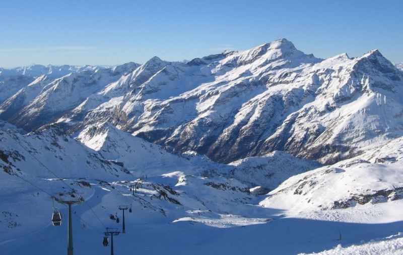
It’s another beautiful day in Alps, with wall-to-wall sunshine and, at altitude at least, relatively pleasant temperatures. After another glorious day tomorrow (Sunday) a weak cold front will start to make its presence felt on Monday…
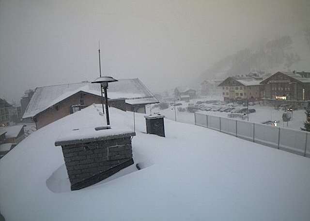
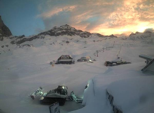
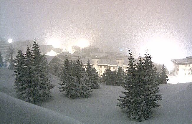
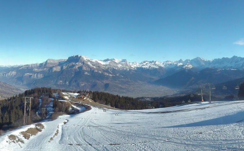
 Patchy snow cover and very limited skiing on offer in Les Gets right now – 31 December 2016 – Photo: lesgets.com
Not only will this cold front introduce colder air, but we will also see a little snow, chiefly across the northern half of the Alps later on Monday/Monday night. Don’t expect very much though - it won’t amount to more than a few centimetres here and there (perhaps 15cm in some favoured spots) - but it will fall to increasingly low altitudes, reaching 400-700m by Tuesday morning.
The rest of the week then looks set to be mostly dry with plenty of sunshine in the western and southern Alps. By contrast, the north-eastern Alps may see further snow showers from time to time. Whatever the case, it will remain cold. Unfortunately, prospects of a more significant storm around the weekend of 7/8 January are (according the latest charts) rapidly disappearing.
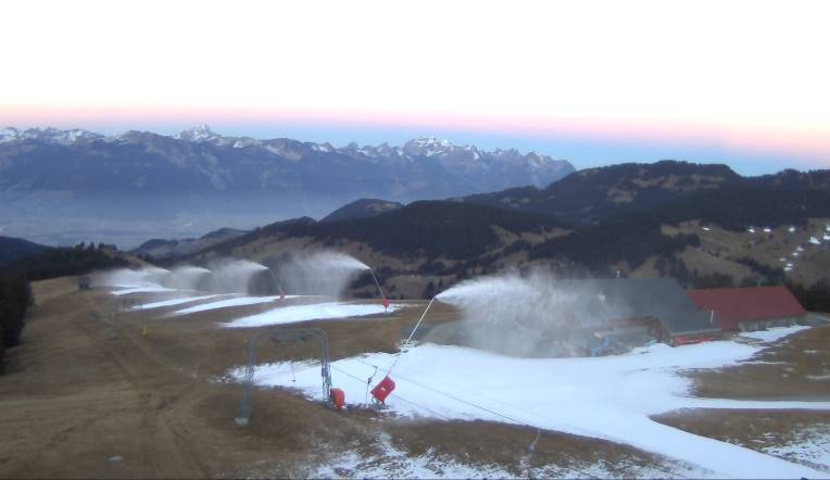
 Good piste skiing in Ischgl thanks to comprehensive snow-making – 31 December 2016 – Photo: ischgl.com
In the meantime, most of the Alps are still desperately short of natural snow. One exception is the eastern Austrian Alps where 15-40cm (locally more) of snow fell earlier in the week, and it looks a little bit more like winter in resorts such as Obertauern. However, as it was very windy during this storm, the snow was deposited in a highly irregular fashion.
The other part of the Alps that is doing well is the south-west - including the Monte Rosa region, Cervinia, Pila, Sestriere, Bardonecchia, Prato Nevoso, Isola 2000, Montgenèvre, Val Cenis, up to and including Val d’Isère and Tignes. These resorts did very well from the storms earlier in the month, though there is still very little or no base below 1800-2000m.
Most other parts of the Alps are heavily (or even in some cases entirely) reliant on artificial snow. For some areas this isn’t a problem (as long as you are not looking for off-piste) with, for example, nearly 1000km of pistes now open in the Super Dolomiti ski area (e.g. Val Gardena, Alta Badia, Kronplatz, Cortina).
In other cases, especially (but not exclusively) in the north-western Alps, the situation is more serious as ski resorts have only been able to open a small percentage of their overall areas. Resorts in difficulty include La Clusaz, the Grand Massif (Flaine, Les Carroz etc.), the Portes du Soleil, Chamonix, Villars and the Jungfrau Region (Wengen, Grindelwald), to name just a few, but there are literally hundreds of resorts in the same boat.
Updated: 9.20am Friday 30 December 2016 - Gloriously sunny until Monday at least…
It’s wall to wall sunshine in the Alps this morning as high pressure remains in charge of the weather in the Alps. After a cold start, it will feel quite pleasant at altitude with light winds and freezing levels somewhere between 1800m and 2200m.
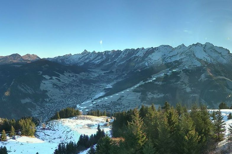
 Desperately short of snow at low altitude in the north-western Alps. This is Villars – 30 December 2016 – Photo: villars.ch
This dry, sunny weather will last until Monday, at which point a weak cold front will arrive from the north introducing much colder air and a little snow here and there. Most of the snow will probably be on the northern side of the Alps, but there is still some uncertainty as to how the cold air will interact with the warm Mediterranean, so there may be one or two surprises for some southern parts of the Alps. Whatever the case, widespread significant snow is NOT expected across the Alps at this stage.
The middle of the first week of January will be cold but mostly dry, then later in the week further (hopefully) more active weather systems will move towards the Alps from the north or north-west. With a bit of luck we could then see much more wintry conditions right across the Alps around the weekend of 7/8 January, but this is still a long way off so still something we are keeping a close eye on.
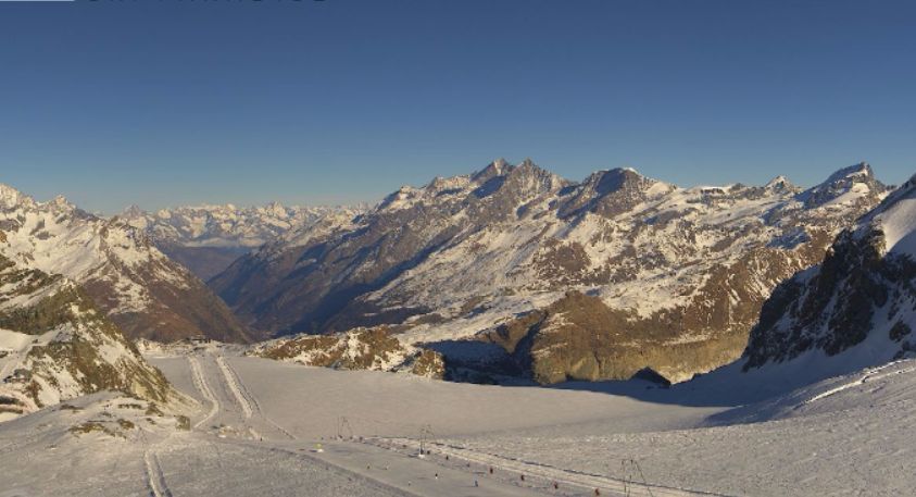
 Good snow cover above 2000m in the Monte Rosa region – 30 December 2016 – Photo: monterosa-ski.com
In the meantime, most of the Alps are still desperately short of natural snow. One exception is the eastern Austrian Alps where 15-40cm (locally more) of snow fell earlier in the week and it looks like winter in resorts such as Schladming, Flachau and Zauchensee. However, it was very windy during this storm, which means that the snow was deposited in a highly irregular fashion.
The other part of the Alps that is doing well is the south-west, which includes the Monte Rosa region, Cervinia, Pila, Sestriere, Bardonecchia, Prato Nevoso, Isola 2000, Montgenèvre, Val Cenis, up to and including Val d’Isère and Tignes. These resorts did very well from the storms earlier in the month, though there is still very little or no base below 1800-2000m.
Most other parts of the Alps are heavily or even in some cases entirely reliant on artificial snow. In some cases this isn’t a problem (as long as you are not looking for off-piste) with, for example, nearly 1000km of pistes now open in the Super Dolomiti ski area (e.g. Val Gardena, Alta Badia, Kronplatz, Cortina).
In other cases, especially (but not exclusively) in the north-western Alps the situation is more serious as ski areas have only been able to open a small percentage of their overall areas. Examples of resorts in difficulty include La Clusaz, the Grand Massif (Flaine, Les Carroz etc.), the Portes du Soleil, Chamonix, Villars, and the Jungfrau Region (Wengen, Grindelwald) to name just a few, but there are literally hundreds of resorts in the same boat.
For more on snow conditions across the Alps see our latest detailed snow report (published yesterday).
 Good snow conditions even quite low down in the eastern Austrian Alps. This is Haus im Ennstal – 30 December 2016 – Photo: haus.at
Updated: 4.50pm Thursday 29 December 2016 - Fresh snow for the eastern Austrian Alps
The northerly blast that delivered 15-30cm (locally 40cm+) of snow to the eastern Austrian Alps yesterday (e.g. Schladming, Zauchensee) has now disappeared, and high pressure is again dominating the weather in the Alps.
 Sunny again in Les Saisies where snow cover is rather patchy – 29 December 2016 – Photo: lessaisies.com
It will therefore remain mostly fine and sunny until the end of 2016. However, early next week we still start to see it turn more generally wintry from the north. In the first instance there may not be a huge amount of snow, but it will turn much colder everywhere with several opportunities for significant snow in the first week to ten days of January.
Snow cover in the Alps remains poor in most areas, with artificial help (snow cannons) very much the order of the day. Indeed some north-western resorts have not seen any snow since the middle of November.
The two main exceptions to this include the eastern Austrian Alps (e.g. Schladming), where 15-40cm of snow (locally even more has fallen in the last 36 hours or so. Also doing well at the moment (thanks to the storms earlier in the month) is the south-west, especially the Italian Piedmont/parts of the Aosta (e.g. Sestriere, Bardonecchia, Cervinia, Monte Rosa) and the French resorts closest to the Italian border from Val d’Isère/Tignes southwards (e.g. Val Cenis, Montgenèvre, Isola 2000).
 Excellent snow conditions in the eastern Austrian Alps. This is Planneralm – 29 December 2016 – Photo: planneralm.at
Just about all other parts of the Alps are seriously short of natural snow and heavily dependent on snow-making. Before Christmas, the lack of crowds and mostly fine weather meant that there was plenty of enjoyable on-piste skiing to be had.
Now that the New Year hordes have descended, however, the pressure for space is much more intense, particularly in areas where only a small proportion of the overall ski area is open.
Generally speaking, the worst affected area is the north-western Alps, from the northern French Alps (Haute-Savoie) through large parts of Switzerland and into the Austrian Arlberg and western Tirol. Some resorts in these regions, especially those furthest west, have not seen any new snow for six weeks.
Updated: 9.50am Wednesday 28 December 2016 - Heavy snow for the eastern Austrian Alps, mostly fine elsewhere…
As expected, it’s snowing quite heavily across some eastern parts of the Austrian Alps this morning, mostly to the east of Salzburg where the rain/snow limit is between 400m and 700m. Elsewhere in the Alps it is mostly dry with plenty of sunshine and much higher freezing levels – as high as 3000m in the west.
 Snowing in Obertauern this morning – 28 December 2016 – Photo: obertauern.at
On Thursday the bad weather will clear the easternmost parts of the Alps with all regions expected to enjoy plenty of fine weather up to and including the weekend. On Monday, a weak cold front will then introduce colder air and a little snow to the northern Alps, heralding the start of an important change in the general weather pattern.
It’s still too early to say just how much snow we will see next week, as the fine detail within the various weather models is still constantly changing. However, it will definitely turn much colder and there is the potential for some significant in some parts of the Alps. Unlike yesterday, it is now the American (GFS) model that is looking most interesting, with a series of snowy storms moving down from the north-west throughout the first two weeks of January.
 High winds and heavy snow in the far eastern Austrian Alps today – 28 December 2016 – Photo: steinerhaus.at
The main European model (ECM) also gives us hope of some significant snow but, with the area of high pressure to our west still a bit too close for comfort, it is not as clear cut. So while we are optimistic about what the New Year might bring, we are not popping the corks just yet!
Snow conditions in the Alps remain challenging in most areas, with artificial help (snow cannons) very much the order of the day. Indeed some north-western resorts have not seen any snow since the middle of November!
The two main exceptions to this include the eastern Austrian Alps (e.g. Schladming), where snowfall totals from this storm are expected to be in the order of 15-40cm to the east of Salzburg, and locally 50cm+ in the far eastern Alps.
Also doing well at the moment (thanks to the storms earlier in the month) is the south-west, especially the Italian Piedmont/parts of the Aosta (e.g. Sestriere, Bardonecchia, Cervinia, Monte Rosa) and the French resorts closest to the Italian border from Val d’Isère/Tignes southwards (e.g. Val Cenis, Montgenèvre, Isola 2000).
Just about all other parts of the Alps are seriously short of natural snow and heavily dependent on snow-making. Before Christmas, the lack of crowds and mostly fine weather meant that there was plenty of enjoyable on-piste skiing to be had. But now that the New Year hordes have descended, the pressure for space is much more intense, particularly in areas where only a small proportion of the overall ski area is open.
Generally speaking, the worst affected area is the north-western Alps, from the northern French Alps (Haute-Savoie) through large parts of Switzerland, into the Austrian Arlberg and western Tirol. Some resorts in these regions, especially those furthest west, have not seen any snow for six weeks.
 Acute shortage of snow at low altitude in the north-western Alps. This is La Chapelle d’Abondance – 28 December 2016 – Photo: snoweye.com
Updated: 11.25am Tuesday 27 December 2016 - Significant snow for the eastern Austrian Alps over next 24 hours
While most of the Alps have remained dry over the festive period, there have been bits and pieces of snow across the far eastern Alps, with a more significant fall forecast here over the next 24 hours.
 Fabulous skiing in Cervinia today – 27 December 2016 – Photo: cervinia.it
The heaviest snow will be to the east of Salzburg, affecting a host of relatively small ski resorts (which may not be familiar to readers in the UK) such as Semmering and Hinterstoder, where 20-40cm (locally a bit more) is possible by the end of tomorrow, with a rain/snow limit between 400m and 800m. It will be very windy, however.
Looking further ahead, and for some time now we have been talking about a more pronounced change to the weather pattern in the Alps early in the New Year. This is still very much on the cards, but how much snow will fall and where is still uncertain as the models struggle for consistency. One thing is for certain, next week will turn much colder right across the Alps.
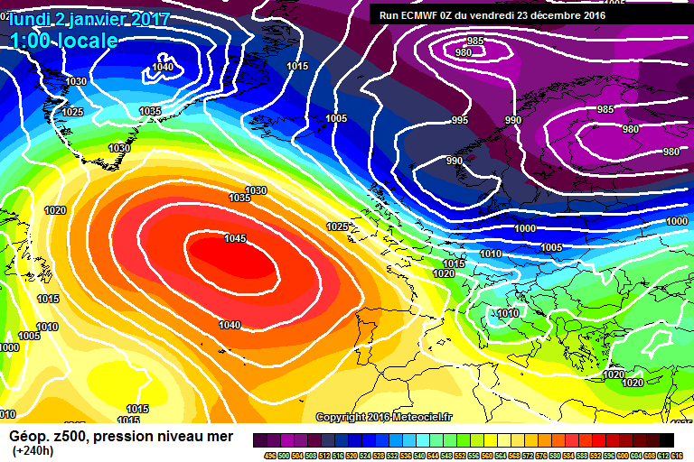
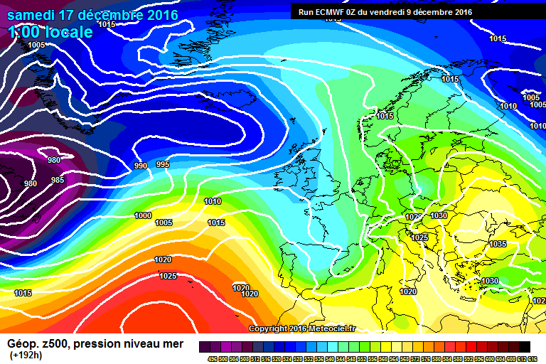
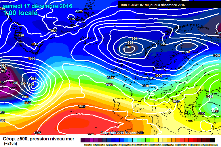
Looking at the main European model (ECM) first (see below), the cold arctic air is set to arrive on Monday 2 January 2017, but is strongly reinforced on Tuesday 3 and Wednesday 4 January, bringing snow to all levels across the northern half of the Alps. Following an improvement in the weather around 5 January 2017, another attack of wintry weather from the north is set to begin around 6/7 January 2017.
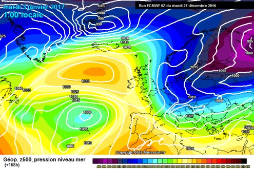 Snow and freezing cold temperatures for the northern Alps if the ECM weather model for 2 January 2017 verifies – Image: meteociel.fr
The main American model (GFS), see below, is not as promising for snow at this stage. It still indicates arctic air being brought in around 1 January 2017, with some snow (mostly for the northern Alps) but in an altogether less convincing fashion.
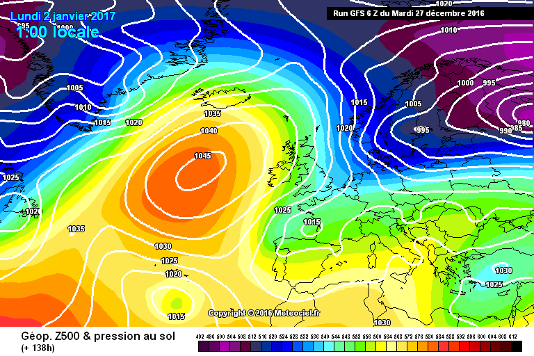 The American GFS model also indicates things getting more wintry in the New Year, but is less convincing for snow than the ECM – Image: meteociel.fr
We’re hoping that the ECM is closer to the mark, but experience tells us that that there is still lots to play for, with plenty of chopping and changing amongst the various weather models to come.
Right now, the best snow conditions in the Alps remain in those areas that were favoured by the Mediterranean storm a week or so ago – mostly in the south-western Alps, including resorts such as Isola 2000, Auron, the Milky Way (Sestriere, Mongenèvre), Bardonecchia, Cervinia, the Monte Rosa Region (Champoluc, Gressoney, Alagna), Pila, Prato Nevoso, Val Cenis, Bonneval-sur-Arc, Val d’Isère and Tignes – to name just a few.
However, the freshest snow is actually in the eastern Austrian Alps, where snow conditions will be fabulous once the bad weather clears later in the week. As mentioned earlier, the main beneficiaries here will be resorts unfamiliar to most readers, such as Hinterstoder, Semmering and Mariazell.
Most of the Alps are still heavily reliant on artificial snow, however, with relatively few ski areas close to being 100% operational. As we have consistently stressed over recent days, there is still some perfectly good piste skiing to be had in the areas that are open. The problem now though is the competition for space created by the influx of New Year skiers.
 Patchy snow cover at low altitude in the north-western Alps – 27 December 2016 – Photo: laclusaz.com
Updated: 10.45am Monday 26 December 2016 - Winter within sight at last?
This morning the weather models are giving us a tantalising glimpse of what might be possible early in the New Year! Of particular interest is the ECM (European model) which delivers a very cold and snowy scenario for virtually the entire Alps for the first week in January. It is a long way off so we still need to be cautious, but one thing is for sure, it will turn much colder next week.
 Many ski resorts are still heavily dependent on artificial snow, particularly low down. This is Alpe d’Huez where around 50 runs are open today – 26 December 2016 – Photo: alpedhuez.net
Back to the here and now and we already have a little fresh snow across some eastern parts of the Alps courtesy of a warm front that grazed the area yesterday. However, any snow was mostly modest in quantity and, with warm air in the mix, it turned it rained to 2000m in places later in the day.
Today will be mostly dry with quite a lot of sunshine across most Alpine regions. However, cloud will again thicken up in north-east later in the day with a few showers here and there (mostly in the Austrian Alps), and a snow-line initially around 1500m but dropping overnight.
 Excellent snow cover at all levels in Isola 2000 in the southern French Alps – 26 December 2016 – Photo: isola2000.com
On Tuesday and Wednesday further showers or longer spells of precipitation will affect the far eastern Alps, especially to the east of Salzburg where some moderate falls of snow are possible at altitude and the rain/snow limit will fluctuate between 500m and 1000m. For the vast majority of the Alps, however, it will again be dry with the best of the sunshine in the west.
Later in the week high pressure will regain control of the weather in the Alps, with lots of sunshine for all Alpine regions expected on Thursday, Friday and Saturday.
As we mentioned earlier, the weather in the Alps then starts to get interesting around the New Year with much colder air pushing down from the north. It is still too early to say how much snow this will bring but certainly the pattern for early January looks much more favourable than it did for much of December.
Meanwhile, snow conditions across much of the Alps are less than ideal for late December. Yes, thanks to artificial help, most resorts can still offer some reasonable piste skiing, but very few (outside some south-western parts of the Alps) are anything like fully operational and with the arrival of the New Year crowds, the pressure will increase rapidly.
The best snow conditions remain in the higher resorts of western Italy (e.g. Monte Rosa region, Cervinia, Pila, Sestriere, Bardonecchia, Prato Nevoso) and a handful of French resorts close to the Italian border such as Isola 2000, Montgenèvre, Val Cenis, Bonneval-sur-Arc, Val d’Isère and Tignes. Note, however, that even here there is very little if any base below 1800-2000m, especially on the French side.
As usual, the Dolomiti Superski area (e.g. Val Gardena, Alta Badia) is the most impressive of those regions heavily reliant on artificial snow, with nearly 1000km of pistes now open! Another example of an impressive ski area open despite challenging conditions, is the Austrian Ski Welt (e.g. Söll, Ellmau) where 154 runs are open today. There is no significant off-piste to speak of outside the south-western Alps.
 Montgenèvre has offered some of the most consistently good snow conditions in the Alps so far this season – 26 December 2016 – Photo: montgenevre.com
Updated: Sunday 25 December 2016 - A little new snow for parts of Austria
A weak weather front is bringing a lot of cloud to the northern side of the Alps today – especially in the north-east where there will be some showers. Most of these showers will be in Austria, with a rain/snow limit starting quite low but rising to as high as 1800-2000m close to the northern foothills later in the day. Snowfall totals are not expected to be significant – just a few centimetres here and there at altitude.
 Good snow cover (but high winds) today in Cervinia – 25 December 2016 – Photo: cervinia.it
For the majority of the Alps it will be another dry day with variable cloud and mild temperatures. Watch out for high winds at altitude, especially in the southern Alps (thanks to the Nordfoehn).
Between Monday and Wednesday further weather fronts will flirt with the eastern Alps bringing further bits and pieces of snow here, especially at altitude, while the western Alps stay mostly dry under the influence of high pressure. All areas are then expected to become fine and sunny again towards the end of the week.
 The Milky Way offers some of the best snow conditions in the Alps right now – 25 December 2016 – Photo: vialattea.it
Looking even further ahead and the various weather models this morning remain consistent in wanting to introduce much colder weather on or around 2 January 2017.
The European model in particular shows the potential for a lot of snow on the northern side of the Alps around 4 January 2017, however, this is still a long way off so is something we will have to monitor closely.
In the meantime, snow cover remains considerably below par for late December across most of the Alps. The main exception is the south-western Alps (e.g. Isola 2000, Prato Nevoso, Milky Way) where snow cover is very good for the time of year.
Elsewhere in the Alps most resorts can offer some perfectly decent piste skiing but are heavily reliant on artificial snow - something that has, generally speaking, been most effective in the eastern Alps.
However, with very few resorts operating at anything like full capacity, it remains to be seen how they cope with the huge increase in numbers expected over the next few days.
 Very patchy snow cover in the Bernese Oberland – 25 December 2016 – Photo: tschentenalp.ch
Updated: 8.50am Saturday 24 December 2016 - White Christmas in the Alps?
Will there be a ‘White Christmas’ in the Alps this year? Well that depends very much on where you are and how you define a ‘White Christmas’ - strictly speaking it has to actually snow on Christmas Day rather than for there just to be snow on the ground. With that in mind, yes it will be a White Christmas for some, but any snowfall will be very modest and confined to the eastern side of the Alps (mostly Austria).
 Plenty of good piste skiing in Madonna di Campiglio, despite its reliance on artificial snow – 24 December 2016 – Photo: funiviecampiglio.it
Back to the weather on Christmas Eve, and mostly places will be dry with the best of any sunshine in the southern and western Alps. However, cloud will thicken up across the northern Alps as the day goes on, especially in the north-east, with some showers in places later in the day.
The showers will chiefly affect the Austrian Alps, north of the main Alpine ridge, but may also clip some northern and eastern parts of the Swiss Alps. The rain/snow limit will range from 700m in the far eastern Austrian Alps to about 1500m in the far western Austrian and Swiss Alps. Accumulations will be modest – a few centimetres here and there, falling mostly tonight.
Christmas Day will see the same east/west split with the eastern Alps rather cloudy and showery. Most of the showers will again fall in the Austrian Alps (away from the far south) but, with milder air nudging in, the rain/snow limit may nudge up to 1600m for a time close to the northern foothills. This limit will stay much lower in the more internal valleys.
Accumulations will again be modest but there is the potential for a few centimetres here and there – perhaps 10-20cm at altitude in a few favoured locations. Elsewhere in the Alps it will again stay mostly dry with the best of any sunshine the further south and west you are.
 Great snow cover at altitude in Val d’Isère – 24 December 2016 – Photo: valdisere.com
Looking a bit further ahead, there will again be some showers in the eastern Alps (mostly Austria) on Tuesday but, generally speaking, most areas will stay dry next week with increasingly sunny skies towards the end of the week.
Yesterday we mentioned the possibility of a return to winter early in the New Year, and this morning’s charts are still looking to introduce much colder air in from the north on or around 2 January 2017. However, it is still far too early to say if this will bring much snow, or if it will be the definitive change in weather pattern that we are looking for. Stay tuned as we will bring you your next update on this on Christmas Day!
 Cervinia remains one of the best bets in the Alps right now – 24 December 2016 – Photo: cervinia.it
As for current snow conditions in the Alps, they remain very mixed. Across most of the Alps natural snow cover is very poor for late December, with resorts heavily reliant on artificial snow, especially below 2200m. However, if you are lucky enough to be in or are about to visit a resort in the south-western Alps (especially in the Italian Piedmont) then snow conditions are much more favourable.
Some resorts that are above par right now include Isola 2000, Montgenèvre, Val Cenis, Bonneval-sur-Arc, Val d’Isère, Tignes, Sestriere, Bardonecchia, the Monte Rosa region, Pila and Cervinia, to name a few. Note, however, that most of these resorts still have little or no base below 1800-2000m, sometimes even higher.
Elsewhere in the Alps there is still some good piste skiing to be had but resorts are much more reliant on artificial snow and will feel the pressure when the crowds move in after Christmas. Of particular concern are the low resorts of the north-western Alps such as Megève, Morzine, Villars, Adelboden and Grindelwald, where only a small fraction of their overall ski areas are open.
Wherever you are weathertoski wishes you a very merry Christmas!
Updated: 11.50am Friday 23 December 2016 - All change for the New Year?
At long last it seems like the weather in the Alps is going to turn significantly more wintry - the only problem being that it won’t happen until the New Year. Until then we do have a little snow in the forecast, as weather fronts graze the north-eastern Alps (chiefly Austria) over the next few days. However, most of the Alps will remain dry for the remainder of 2016.
 ECM surface pressure chart for 2 January 2017, which could produce a lot of snow in the Alps. It’s not a done deal yet though – Image: meteociel.fr
In terms of the weather pattern change due in the New Year, current indications are that it will start to turn much more wintry from the north on or around 2 January 2017. It’s by no means a done deal yet, but we are certainly moving in the right direction - fingers crossed we will see some significant snow early in 2017.
Before then the best chance of any fresh snow will be in Austria (away from the south) with a dusting of snow (1000-1500m) here and there this weekend, perhaps followed by a more significant fall in the eastern Austrian Alps on Tuesday (700-100m). More on this in our latest weather forecast for the Alps published later today…
 Fabulous snow conditions in the Milky Way region. This is Sestriere – 23 December 2016 – Photo: vialattea.it
Current snow conditions in the Alps are very mixed. Following the fresh snow earlier in the week, there are excellent conditions in resorts in the western Italian Alps and some French resorts close to the Italian border, including Isola 2000, Montgenèvre, Val Cenis, Prato Nevoso, Sestriere, Bardonecchia, Cervinia and the Monte Rosa region.
Note that Val d’Isère and Tignes are also still in great shape (at least at altitude) following the big storms here earlier in the month. However, most of the Alps still have an acute shortage of snow and are heavily reliant on man-made efforts – see our latest snow report for more detail.
 Plenty of pistes available in Ellmau but mainly on artificial snow – 23 December 2016 – Photo: skiwelt.at
The areas that will be most concerned as we approach the festive rush will be the lower resorts of the north-western Alps such as Morzine, Megève, Villars, Adelboden and Grindelwald, where only a small percentage of their overall ski areas are open.
Broadly speaking, snow-making has proved more effective the further east you are, enabling areas such as the Dolomites and Austria’s Ski Welt to open the majority of their runs.
Updated: 10.40am Thursday 22 December 2016 - Powder day for some south-western parts of the Alps…
High pressure is once again in control of the weather in the Alps, which means plenty of sunshine today (above any low level cloud/fog). With the air coming in from the south-west, it will also be quite mild, with freezing levels between 2400m and 2700m.
 Fabulous snow conditions in the Italian Piedmont. This is Bardonecchia – 22 December 2016 – Photo: bardonecchia.com
Regular followers of weathertoski will know that we have seen a lot of fresh snow in some south-western parts of the Alps over the last two to three days. The heaviest snow fell in the Italian Piedmont (e.g. Sestriere, Sauze d’Oulx, Bardonecchia, Prali and Alagna), with typically 40-80cm above 1800m, but over 1m in a few places such as Prato Nevoso close to the Mediterranean.
Some parts of the Aosta valley (e.g. Gressoney, Champoluc, Cervinia, Pila), the southern French Alps (e.g. Isola 2000) and the upper Maurienne Valley (e.g. Bonneval-sur-Arc) also saw significant snow but, on the French side at least, there was also a lot of wind. It is also worth remembering that in most of these areas there is no real base at low altitude so unless you know exactly what you are doing you really need to be hiring a guide if you want to go off-piste.
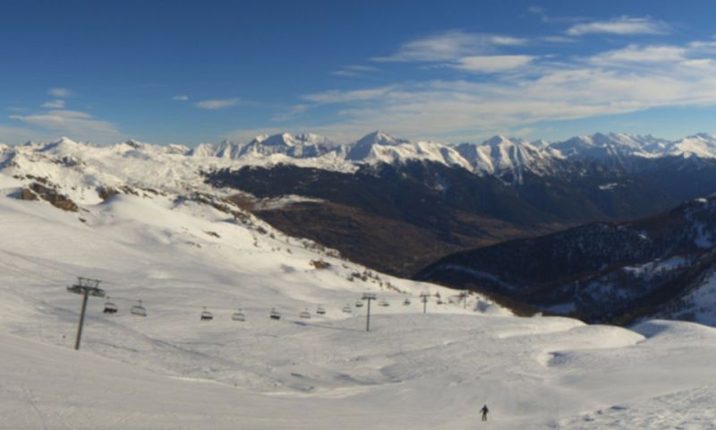
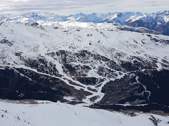 Méribel-Mottaret viewed from the top of Saulire yesterday – Photo: weathertoski.co.uk
Elsewhere in the Alps there was a little light snow here and there earlier in the week, especially in Austria, but not generally enough to make any difference to the overall conditions. As a rule, there is still plenty of good piste skiing on offer (thanks in no small part to snow-making) but very few off-piste opportunities and still a serious dearth of snow at low altitude.
The resorts facing the greatest difficulties as we approach the busy festive period are the low ones of the north-western Alps, including Morzine, Les Gets, Megève, Villars, Grindelwald and Adelboden, all of which are only able to offer a tiny handful of runs. Generally speaking, the further east you are, the more effective snow-making has been. Today, for example, there are 872km of pistes open in the Dolomiti Superski area (e.g. Val Gardena, Alta Badia, Kronplatz, Cortina).
The medium term weather forecast for the Alps is not great, with little or no snow expected in the western Alps for the foreseeable future. Further east, weather fronts will affect Austria and perhaps some parts of Switzerland later this weekend and at times next week, with some snow in places – especially for the northern and eastern Austrian Alps. However, how much snow will fall is still uncertain at this stage and most of the Alps will miss out.
Updated: 9.30am Wednesday 21 December 2016 - Snow dying away from the south-western Alps, otherwise mostly fine
Weathertoski is in Courchevel 1850 – courtesy of the Hotel Barrière Les Neiges – where there is still a little cloud spilling over from the direction of Italy this morning, but we are expecting much more sunshine today than we have seen so far this week.
 A mostly sunny in prospect here in Courchevel 1850 where the pistes are in surprisingly good shape – 21 December 2016 – Photo: weathertoski.co.uk
Courchevel has done a fantastic job with the relatively little snow they have to play with, and yesterday we enjoyed some excellent piste skiing with the ever enthusiastic Adam Whale from New Generation. Above 2200m or so there is still reasonable natural cover, but below this level impressive snow-making ensures an easy return to resort. The best snow, as always it seems, was found on the shady Combe de Saulire.
Meanwhile, just across the Italian border it has been snowing heavily since Monday, especially in the Piedmont where 50-100cm has fallen quite widely – more still in the far south (e.g. Prato Nevoso). Parts of the Aosta valley have also done well, as have the far southern French Alps.
Resorts that have lots of fresh snow right now include Isola 2000, Prato Nevoso, Limone, Sestriere, Sauze d’Oulx, Bardonecchia, Pila, Cervinia and the Monte Rosa region (especially Alagna). Today the last of the snow will gradually die away from these western Italian resorts but not before a few more centimetres have been added here and there.
 Nothing wrong with snow conditions in the Italian Piedmont right now. This is Bardonecchia – 21 December 2016 – Photo: bardonecchiaski.com
For much of the rest of the Alps it’s a mostly sunny day in prospect. Indeed it should remain dry and mostly sunny (above any low-lying cloud/fog) until Sunday, at which point a weak weather front will introduce a little rain/light snow to some northern or north-eastern parts of the Alps, but nothing significant.
Looking a bit further ahead and the news isn’t great, with high pressure generally dominating the weather in the Alps for the foreseeable future. A blast of arctic air will come close to the eastern Alps next week but will probably end up hitting the Balkans, bringing lots of fresh snow to Bulgarian resorts. For the Alps, and the Pyrenees for that matter, there is very little if any new snow likely this side of the New Year. If anything changes, however, we will of course be the first to tell you!
Snow conditions in the Alps are therefore less than ideal as we approach one of the busiest periods of the season. However, it should be stressed that there is still lots of very enjoyable skiing to be had, and that (all things considered) the overall situation is probably not as bad as this time last year, or the year before.
As we have already pointed out, the snow is fabulous in some south-western parts of the Alps, especially in the Piedmont, even quite low down. Elsewhere in the Alps you generally have to go quite high to find a natural base, but with artificial help there is plenty of piste-skiing on offer. The main exception to this is in the low resorts of the north-western Alps (e.g. Megève, Morzine, Villars) where only a tiny number of runs are open.
Tune in tomorrow for a detailed assessment of snow conditions across the Alps and beyond…
Updated: 7.40am Tuesday 20 December 2016 - Further heavy snow for some south-western parts of the Alps, otherwise mostly dry
Weather to ski is in Courchevel 1850 where it is cloudy but dry first thing this morning with a temperature of about -2°C. Today we are expecting it to remain rather cloudy but without any real snowfall, which is still (mostly) confined to the Italian side of the border.
 Rather cloudy, windy but dry this morning in Courchevel 1850 – 20 December 2016 – Photo: weathertoski.co.uk
Since we last reported on Sunday the anticipated “south-western storm” has struck, with the heaviest snow falling in the Italian Piedmont (e.g. Bardonecchia, Sestriere, Alagna), parts of the Aosta Valley (e.g. Pila), as well as the far south-eastern French Alps (e.g. Isola 2000).
These exact same areas are likely to see the lion’s share of the snow again today, with storm totals of 50-100cm in many places by the time things start to clear up on Wednesday – more still in Italian resorts closest to Genoa, such as Prato Nevoso, Limone.
 Significant fresh snow in the Italian Piedmont. This is Sestriere – 20 December 2016 – Photo: vialattea.it
Elsewhere in the Alps there was a little snow here and there on Sunday and/or Monday, especially in the eastern Alps where many low-lying Austrian resorts at least now look more wintry, even if snow depths remain very modest.
Generally speaking though there remains a serious shortage of the white stuff at low altitudes, especially in the north-western Alps (in the likes of Morzine, Megève and Villars) where it hasn’t snowed properly for over a month.
If you are looking for a proper return to winter any time soon, the forecast is unfortunately not great. A little snow is likely in parts of the northern Alps this weekend, and into the first part of next week but it probably won’t be significant and high pressure could well dominate the weather again after Christmas.
Updated: 10.25am Sunday 18 December 2016 - Heavy snow for some south-western parts of the Alps early this week.
There have been some important developments in the weather in the Alps since we last reported on Friday. Today, a weak cold front will bring a little light snow to some north-eastern parts of the Alps (chiefly eastern Austria). More importantly, however, a rapidly developing area of low pressure in the Mediterranean will bring heavy snow to some south-western parts of the Alps between Monday and Wednesday.
 Lots of snow anticipated in some south-western parts of the Alps this week. These are the expected snowfall totals between now and Wednesday – Image: bergfex.com
This “south-western snow” will start tomorrow, then peak on Tuesday before dying away again later on Wednesday. It will be most significant in the far south-western Italian Alps (e.g. Limone, Prato Nevoso) where over 1m of snow is possible.
Other areas that are expected to catch significant snow include the French Queyras (e.g. Abriès), the Milky Way (e.g. Sestriere, Montgenèvre), the upper Maurienne (e.g. Bonneval-sur-Arc, Val Cenis), Val d’Isère, Cervinia, Pila, the Monte Rosa region, Zermatt and Saas-Fee. However, as is always the case in this particular set-up, snowfall quantities are hard to predict. How far the snow will spill over the border into France and Switzerland is also hard to forecast. For example, Val d’Isère may get a moderate fall while just down the road Ste-Foy gets next to nothing.
Aside from a dusting of snow in the north-eastern Alps today, the northern half of the Alps will again see very little snow from this latest storm. The eastern side of the southern Alps (e.g. the Dolomites) won’t see a great deal either.
Looking a bit further ahead and, after a mostly fine end to the week in all Alpine regions, the weather looks like breaking down from the west towards the weekend. This could bring some welcome snow to some northern and western parts of the Alps in time for Christmas, but there is still considerable uncertainty at this time – to be confirmed.
In the meantime, there is of course plenty of skiing to be had across the Alps, even if most resorts are heavily dependent on artificial snow. The best natural cover is at altitude in the south-western Alps (e.g. Sestriere, Montgenèvre, Pila and the Monte Rosa region), where snow levels will increase significantly again this week.
Updated: 8am Friday 16 December 2016 - Tentative changes in next week’s weather patterns
The weather in the Alps will remain largely fine up to Sunday - at the very least. Next week, it will turn slightly more unsettled from the south, but at this stage any snowfall looks like being modest and localised.
 Excellent snow conditions in Montgenèvre – 16 December 2016 – Photo: montgenevre.com
The models are still chopping and changing but the best chance of any snow at all in the first half of next week is in the far south-western Alps (e.g. Isola 2000). It should be stressed, however, that even this is highly uncertain and that the vast majority of the Alps will remain dry.
Showers or flurries may become a little more widespread later next week but, again, disagreement among the various weather models means that there remains lots of uncertainty in the medium term. In short, we may see bits and pieces of snow here and there in the run up to Christmas but widespread significant snow seems unlikely.
As regular followers of weathertoski will know, there is still plenty of enjoyable skiing to be had as long as you don’t mind staying on the pistes. Off-piste possibilities are extremely limited – unless you are prepared to hire a good guide and hike a long way off the beaten track (in the high border areas between France and Italy, for example).
 Serious lack of snow in the Portes du Soleil. This is Châtel – 16 December 2016 – Photo: chatel.com
The best natural snow cover remains at altitude in the western/south-western Alps including resorts such as Tignes, Val d’Isère, Bonneval-sur-Arc, Val Cenis, Montgenèvre, Sestriere, Prali, Bardonecchia, Pila, Cervinia and the Monte Rosa Region.
Most other parts of the Alps can also offer plenty of skiing now but are much more reliant on artificial snow. Generally speaking, snow-making has been more effective in the eastern Alps (e.g. Ski Welt, Dolomiti Superski) than in the west (e.g. Portes du Soleil).
However, temperatures will remain relatively cool everywhere over the next week or so which means that all regions should benefit (from snow-making) in the run up to Christmas.
Updated: 10am Thursday 15 December 2016 - Turning slowly more unsettled from Sunday?
Guess what? We have another mostly sunny day in store for the Alps, at least above the usual areas of fog/low cloud that can a nuisance in the lowlands during settled weather at this time of year – especially close to the foothills. Freezing levels today will be at their lowest (around 1500m) in the far eastern Alps, but more generally between 2000m and 2500m.
 Patchy low altitude snow cover in Zell-am-See – 15 December 2016 – Photo: zellamsee-kaprun.com
It will continue mostly fine until Sunday with freezing levels tending to fall, especially in the southern Alps, which is good news for snow-making. On Sunday, however, the weather models stop agreeing and there is more uncertainty in the forecast. In all likelihood the dry weather will continue but there is the outside possibility of a little light snow moving into some northern and eastern parts of the Alps. If this does happen, however, it probably won’t amount to very much at all.
Next week, with low pressure developing in the Mediterranean, the focus shifts onto the southern Alps. Again there is lots of uncertainty at present, but there is the potential for some significant snow in places, especially in the western Italian Alps (e.g. Sestriere). The weather in the Alps may become more generally unsettled later next week but this a long way off and lots of pieces of the jigsaw still have to come together before this can happen.
 Fabulous piste skiing in Montgenèvre – 15 December 2016 – Photo: montgenevre.com
So, what are the chances of any widespread or significant snow before Christmas?
In summary, the weather in the Alps will remain fine until Sunday at least. Thereafter, the chances of snow gradually increase. However, there is still plenty that can go wrong and we are still a long way off saying that there will be any widespread or significant snow before Christmas.
In the meantime, snow cover in the Alps remains very patchy below 2000m. Indeed, it hasn’t snowed below 1800m for a month now in many north-western parts of the Alps (e.g. Verbier, Chamonix, Courchevel). Above 2000m, however, snow cover is generally ok, at least on north-facing slopes. It is even above average for the time of year at altitude in some western/south-western resorts such as Val d’Isère, Val Cenis, Montgenèvre, Pila and Sestriere. That said, the vast majority of resorts are heavily dependent on artificial snow with very few if any serious off-piste opportunities.
Updated: 10.50am Wednesday 14 December 2016 - More of the same
Today we have another weak disturbance bringing a few showers to the extreme eastern Austrian Alps (mostly to the east of Salzburg), with a dusting of snow about 800-1100m. With high pressure still in control, however, everywhere else will be dry with plenty of sunshine (above any low-lying cloud or fog). Freezing levels will range from about 1400m to 2400m east to west.
 Patchy snow cover below 2000m in the northern French Alps. This is Les Saisies – 14 December 2016 – Photo: lesaisies.com
The rest of the week looks set to continue mostly fine with cold nights (ideal for snow-making) and pleasant (in the sun at least) but not excessively mild daytime temperatures.
Next week things get a bit more complicated. The latest charts point to some snow for the extreme south-western Alps on Monday (e.g. Isola 2000, Limone) as well as the far eastern Austrian Alps, but only in modest quantities. Snow may become a bit more widespread across the southern Alps mid-week, but there is still lots of uncertainty about this at this stage.
One thing is for certain though, there still won’t be much snow getting through to the northern Alps until later next week at the earliest. That said, the European weather model (ECM) does currently show some significant snow for much of the Alps on 24 December. Whether this model has picked up on a trend, we shall just have to wait and see - at the time of writing the American GFS model doesn’t show a serious change in the weather pattern until well after Christmas.
 Still excellent snow cover at high altitude in the south-western Alps. This is the Monte Rosa region – 14 December 2016 – Photo: monterosa-ski.com
In the meantime, as anyone who has been skiing in the Alps over recent days will know, there is actually plenty open, even if off-piste opportunities are extremely limited or non-existent.
The greatest concentration of open pistes is actually in the Dolomiti Superski area (e.g. Val Gardena, Alta Badia, Kronplatz, Cortina) where 667km of runs are open, testament to their extraordinary snow-making abilities. The best natural snow cover, however, remains at altitude in western/southern Alps in resorts such as Tignes, Montgenèvre and Sestriere.
Updated: 8.15am Tuesday 13 December 2016 - Breakdown from the south this weekend?
A weakening cold front brought a little snow to parts of Austria yesterday – generally in modest quantities, but with 20cm+ in one or two favoured spots to the east of Salzburg. Other parts of the Alps (including southern Austria) stayed dry with lots of sunshine in the west.
 A little new snow for parts of Austria. This is Lofer in the Salzburgland – 13 December 2016 – Photo: skialm-lofer.com
Today all Alpine regions should remain dry with plenty of sunshine and freezing levels generally between 1500m and 2500m (east to west). Indeed it will remain fine for the rest of the week with just the odd flurry in the extreme north-eastern Alps on Wednesday. It will remain relatively cool, however, which will aid snow-making, especially in the eastern Alps.
So when exactly will we next see any significant snow in the Alps?
The answer isn’t straightforward. According to this morning’s weather models, it looks likely that any major changes in the weather will come from the south, with heavy snow possible later this weekend in the far southern French Alps (e.g Isola 2000, Auron) and south-western Italian Alps (e.g Limone, Prato Nevoso). This snow may become more generalised across the southern Alps next week, but right now the jury is still out as to whether any snow will get through to the northern side of the Alps.
Whatever the case, we should stress that the models are still very volatile, with plenty of room for some surprises in the run up to Christmas.
 Snow-making in Lech –13 December 2016 – Photo: Lech.com
So, with the exception of some eastern parts of the Austrian Alps, most areas are once again faced with very little natural snow below 2000m as we reach the middle of December. Indeed this is the fourth below par start to the season in a row, and the third where the shortage of snow could be described as acute, at least in the northern and north-western Alps. That doesn’t mean that there isn’t plenty of enjoyable skiing to be had though. Hundreds of resorts are now at least partially open, even if most are heavily reliant on artificial help.
Some of the better options right now include Val d’Isère, Tignes and Montgenèvre in France, and Sestriere, Pila and Cervinia in Italy. Also deserving a special mention is the Dolomiti Superski area (e.g. Cortina, Kronplatz, Alta Badia, Val Gardena) where 667km are currently open - almost entirely on artificial snow.
Updated: 8am Monday 12 December 2016 - A little fresh snow across the far north-east, otherwise mostly fine again
A weakening cold front will bring a little snow across some parts of Austria today. However, for the vast majority of the Alps it’s another dry day with lots of sunshine in the west. What’s more, there won’t be any significant change in the broad-scale weather pattern any time soon, which means that the Alps are unlikely to see a proper return to winter before Christmas.
 Snowing above 800m or so in Zell-am-See this morning, but it won’t be hugely significant – 12 December 2016 – Photo: zellamseekaprun.com
Back to today, and we have showers (snow 500-1000m) across the north-east, mostly in the northern and eastern Austrian Alps (e.g. Salzburgland, western Styria and Upper Austria). These regions could see a few centimetres of snow, but most other parts of Austria will be dry with the best of any sunshine in the far south (Carinthia).
The odd shower might also clip the far east of Switzerland, but the majority of the Alps will have another magnificent day with slightly cooler temperatures than we have seen recently (freezing levels peaked at 3700m in some parts of the Alps on Saturday).
As for the rest of the week: another very weak front may again clip the extreme east of the Alps on Wednesday, but for everyone else it will once again be dry with plenty of sunshine. It will be cooler than last week, however, with freezing levels typically between 1500m and 2300m, sometimes a bit lower in the far eastern Alps.
 More blue skies across the French Haute-Savoie today. This is the view from the slopes of Megève/Combloux – 12 December 2016 – Photo: combloux.com
So once again, many areas are facing a shortage of natural snow as we approach the Christmas period. This is the fourth below par start to the Alpine season in a row and the third year in the row where the shortage of snow can be described as acute at low altitude, especially in the north-western Alps (e.g. Morzine, Megève, Villars).
Only one month ago we were talking about the best mid-November snow since 1996 in these same areas (although admittedly only at altitude). This goes to show just how quickly things can change at this time of year. Just about everything that could have gone wrong since then did (in the northern Alps in particular) - with heavy rain followed by a protracted period of Foehn, then endless sunshine.
However, it is not all doom and gloom - as anyone who has been skiing in the Alps recently will be quick to point out. If you are happy sticking to the pistes then there are plenty of options and, with low humidity/dew points, snow conditions have actually been quite good. The worst weather that you could have at this time of year is cloudy, windy, mild and wet conditions and these have largely been avoided in recent days. Indeed weather conditions in the Alps will be ideal for snow-making again this week.
The best snow conditions remain in the high resorts of the western/south-western Alps such as Val d’Isère, Tignes, Montgenèvre, Val Thorens, Pila, Monterosa Ski and Zermatt. However, dozens of other resorts right across the Alps are also offering good piste skiing, usually with considerable artificial help.
The Dolomiti Superski area (Cortina, Selva, Alta Badia, Kronplatz etc.) now has an incredible 671km of skiing open, testament to some of the finest snow-making facilities in the world.
However, all this cannot disguise the fact that there is very little natural snow below 2000m across most of the Alps, and that off-piste opportunities are extremely limited.
Updated: 10.50am Sunday 11 December 2016 - A little snow in the north-east otherwise still mostly fine
Broadly speaking, high pressure is still in charge of the weather pattern in the Alps. A weakening cold front will bring a little snow to some north-eastern parts of the Alps later today and tomorrow but, for the vast majority of regions, the next few days will remain dry with plenty of sunshine.
 Plenty of snow at altitude in Serre Chevalier – 11 December 2016 – Photo: serre-chevalier.com
This afternoon, any showers will tend to be confined to the northern Austrian Alps (perhaps also the extreme north-eastern Swiss Alps) with a rain/snow limit between 1200m and 1700m, lowering tonight. Showers will continue for a time in these same north-eastern parts of the Alps tomorrow, these being heaviest to the east of Salzburg with the snow-line falling to between 500m and 1000m. Snowfall totals will generally be modest but could reach 10-15cm in some favoured parts of Upper Austria, such as at altitude in Hinterstroder, for example.
The rest of the week again looks mostly dry and sunny for much of the Alps though a few showers or flurries (of no real significance) are again possible in the far east. It will, at least, be considerably cooler than in recent days (freezing levels reached 3700m in places on Saturday) which will allow snow-making to run at something like full capacity.
 Patchy snow cover in the (relatively high) upper Tux valley – 11 December 2016 – Photo: foto-webcam.eu
Later in the week and next weekend some instability is possible in the southern Alps which could result in some snow here. However, there is a still lot of uncertainty surrounding this and the overall weather remains unfavourable for a more decisive return to winter any time soon.
In the meantime, there is actually lots of enjoyable skiing to be had in the Alps, at least if you are happy to stay on the marked runs. The best snow conditions remain in the high resorts of the western/south-western Alps such as Val d’Isère, Tignes, Montgenèvre, Val Thorens, Pila, Monterosa Ski and Zermatt. However, dozens of other resorts right across the Alps are also offering good piste skiing, usually with considerable artificial help.
The Dolomiti Superski area (Cortina, Selva, Alta Badia, Kronplatz etc.) now has an incredible 684km of skiing open, testament to some of the finest snow-making facilities in the world.
However, all this cannot disguise the fact that there is very little natural snow below 2000m across most of the Alps, and that off-piste opportunities are extremely limited.
Updated: 7.45am Saturday 10 December 2016 - Sunny and exceptionally mild at altitude
It’s another glorious day in store for the Alps, with lots of sunshine and freezing levels pushing 3500m in most places. Today will see the peak of the current very mild spell as cooler air begins to filter down from the north tomorrow.
 Another glorious day in the Alps. This is the view from the higher slopes of Méribel – 10 December 2016 – Photo: merinet.com
This cooler air comes courtesy of a weakening cold front that will bring a little snow later on Sunday and on Monday to the north-eastern Alps (mostly to the east of Salzburg) but only in modest quantities. Most of the Alps will, however, stay dry.
Looking a bit further ahead, and there is still no real sign of a return to winter any time soon. Some changes are forecast towards next weekend but it looks like they will be short-lived and, in any case, will not involve a great deal of snow. High pressure then looks likely to reassert itself in the run up to Christmas. We will look at this in a bit more detail tomorrow…
In the meantime, there is actually lots of very enjoyable skiing to be had in the Alps. The best snow conditions remain in the high resorts of the western/south-western Alps such as Val d’Isère, Tignes, Montgenèvre, Val Thorens, Pila, Monterosa Ski and Zermatt. However, dozens of other resorts right across the Alps are also offering good piste skiing, usually with considerable artificial help.
The Dolomiti Superski area (Cortina, Selva, Alta Badia, Kronplatz etc.) now has an incredible 675km of skiing open, testament to some of the finest snow-making facilities in the world.
However, all this cannot disguise the fact that there is very little natural snow below 2000m across most of the Alps, and that off-piste opportunities are extremely limited.
Updated: 8.10am Friday 9 December 2016 - Will it snow again before Christmas?
Yesterday we showed you the European weather model (ECM) for Saturday 17 December 2016, which offered us the tantalising prospect of some widespread and significant snow for the Alps next weekend. As we made clear, however, it was always a long shot this far out and, sure enough, the same model offers us a different outcome this morning.
 Unlike this time yesterday, today’s European model (ECM) only favours the southern Alps for any upcoming snow – Image: meteociel.fr
If we look at this morning’s ECM run, it still shows a breakdown in the weather next Friday/Saturday. However, with pressure remaining high over Eastern Europe, the storm cannot cross the Alps. Instead, by remaining centred to the west, it will draw up a vigorous southerly airflow which would (if verified) deliver copious quantities of snow to the southern side of the Alps but create a strong Foehn effect in the north. In short, this particular outcome would be no good at all for the resorts that need new snow the most - the lower resorts of the northern and eastern Alps.
If we look at the other main model this morning, the GFS (American model), then the news isn’t very good at all with no real sign of a major change in the weather before Christmas. In fact the closest we get to some significant snow here is from a pool of cold and unstable air over south-eastern Europe, which is edging towards the Austrian and eastern Italian Alps. Overall, however, it spells snow-drought for the foreseeable future.
 The American model (GFS) shows a very different outcome to the European model (ECM), with no breakdown from the west but some cold and unstable air pooling in the south-east – Image: meteociel.com
So can these models be wrong? Well, it depends on what timescale you are looking at. Until the weekend of 17/18 December (at the very least) there is almost no chance of a significant change in the weather pattern. There is still hope after that, but with the various weather models still chopping and changing on a daily basis, we are in the lap of the Gods for the moment.
Back to the here and now, and the weather in the Alps will be mostly sunny and (at altitude at least) very mild over the next couple of days with freezing levels in excess of 3000m. It will turn a bit colder later this weekend and into the first part of next week. There will even be a little snow in the eastern Austrian Alps on Sunday evening and into Monday (mostly to the east of Salzburg), but nothing really significant.
In the meantime, there is actually lots of very enjoyable skiing to be had in the Alps. The best snow conditions remain in the high resorts of the western/south-western Alps such as Val d’Isère, Tignes, Montgenèvre, Val Thorens, Pila, Monterosa Ski and Zermatt. However, dozens of other resorts right across the Alps are also offering good piste skiing, usually with considerable artificial help.
The Dolomiti Superski area (Cortina, Selva, Alta Badia, Kronplatz etc.) now has an incredible 660km of skiing open, testament to some of the finest snow-making facilities in the world.
However, all this cannot disguise the fact that there is very little natural snow below 2000m across most of the Alps, and that off-piste opportunities are extremely limited.
Updated: 8.30am Thursday 8 December 2016 - Snow on the horizon?
Wondering when we will next see significant snowfall in the Alps? Well, this morning the charts are finally offering us a glimmer of hope, with a possible pattern change around the weekend of 17/18 December. However, we should stress that it is only a ‘glimmer’ of hope and needs much more verification before we can say that it is “game on” again before Christmas.
 Surface pressure chart for Saturday 17 December 2016 which, if verified, would deliver plenty of snow for the Alps – Image: meteociel.fr
Before that there is a little snow in the forecast for Monday, but only in the eastern Austrian Alps and not, in any case, amounting to more than a few centimetres here and there. Otherwise high pressure continues to dominate the weather in the Alps with plenty of sunshine in most regions for the next week, at the very least.
The chart that is offering us the most hope is the European model for Saturday 17 December (above). Were this to check out then we would see heavy snow for many parts of the Alps. However, the GFS (American) model is not (at the time of writing) playing ball, preferring to wait until 21 December before introducing anything notably wintry. All eyes on how both the European and American models develop later today…
 Montgenèvre offers some of the best entirely non-glacial snow conditions in the Alps right now – 8 December 2016 – Photo: montgenevre.com
In the meantime, there is actually lots of very enjoyable skiing to be had in the Alps. The best snow conditions remain in the high resorts of the western/south-western Alps such as Val d’Isère, Tignes, Montgenèvre, Val Thorens, Pila, Monterosa Ski and Zermatt. However, dozens of other resorts right across the Alps are also offering good piste skiing, usually with considerable artificial help.
The Dolomiti Superski area (Cortina, Selva, Alta Badia, Kronplatz etc.) now has an incredible 608km of skiing open, testament to some of the finest snow-making facilities in the world.
Updated: 9.45am Wednesday 7 December 2016 - Sun, sun, sun!
High pressure continues to dominate the weather in the Alps. If you have been following our reports this week you will know that we have been talking about the possibility of a little snow for the north-eastern Alps on Sunday/Monday. However, even that is looking unlikely in some of the charts this morning.
 Fabulous piste skiing continues in Val d’Isère – 7 December 2016 – Photo: valdisere.com
So when will we next see some proper snow? We can say with nearly 100% certainty that there will be no significant new snow in the Alps for the next 10 days. Realistically though it could be much longer still. Freezing levels are also increasing, peaking at 3500m in places on Friday/Saturday before it turns a little cooler again next week.
So what does this mean for snow conditions in the Alps? One thing we will see with the higher temperatures this week is increased snow-melt at lower/medium altitudes, especially in areas exposed to the sun. With relatively low dew points, however, any melting on shadier north-facing slopes will be much slower and, generally speaking, piste conditions should remain pretty good. Snow-making probably won’t be as prolific as it was last week but it will continue in many places, particularly at night.
 Snow-making in the Trentino Dolomites. This is the Col de Valvacin – 7 December 2016 – Photo: dolomitisuperski.com
Dozens of resorts are now partially open across the Alps though off-piste opportunities are extremely limited. Some of the best snow and most extensive skiing opportunities are still to be found in Tignes, Val d’Isère and Cervinia. However, other good options right now include Val Thorens, Montgenèvre, Pila, Courmayeur, the Monte Rosa Region, Livigno, Zermatt, Saas-Fee, Ischgl and Obertauern, to name just a few.
The Dolomites also deserve a special mention as, despite very little natural snow, hundreds of kilometres of pistes are now open here– 565km now in the SuperDolomiti area alone!
Updated: 9.15am Tuesday 6 December 2016 - Still fine, some snow for the north-east on Sunday/Monday
The weather in the Alps will remain dry and mostly fine all week. The next snow is scheduled to fall on Sunday/Monday, but will only affect some northern and north-eastern parts of the Alps (e.g. Austria).
 Excellent snow cover still at altitude in the Monte Rosa region – 6 December 2016 – Photo: monterosa-ski.com
Freezing levels will increase steadily over the next few days (reaching 3000m+) before falling again next week. Looking even further ahead, it looks like high pressure will dominate the weather in the Alps for quite some time. A few flurries could creep into the southern and eastern Alps at times but, apart from the snow forecast for the north-eastern Alps this Sunday/Monday, there is no widespread significant snow in the offing for at least 10 days, probably more. That said, there will be plenty more opportunities for snow-making, especially next week when temperatures fall again across the board.
Snow conditions in the Alps are quite mixed right now but, all things considered, better than they were this time last year (or the year before for that matter). Resorts with lots of skiing above 2000m are generally in reasonable shape, especially the higher resorts of the western/south-western Alps - the very best skiing on offer still being in Tignes, Val d’Isère and Cervinia, all of which got hammered by the big storm some 10 days or so ago.
 Snow-making continues in the Dolomites. This is San Pellegrino – 6 December 2016 – Photo: dolomitisuperski.com
Elsewhere in the Alps, there is also plenty of decent piste skiing, though in most cases artificial snow is a significant factor. In the eastern Alps in particular (e.g. the Dolomites and the Ski Welt) artificial snow has also allowed an impressive number of runs to open at low altitudes. Nevertheless, we can’t escape the fact that, unless a major change in the weather patterns is signalled soon, we are looking at yet another run-up to the festive period with very limited natural snow cover below 2000m.
Updated: 8am Monday 5 December 2016 - Fine all week
High pressure is still dominating the weather in the Alps and will continue to do so all week. There is a chance that some northern and eastern parts of the Alps might see some snow this time next week but this is far from certain, and the bigger picture is still unfavourable in terms of a more sustained return to winter any time soon.
 Magnificent day in Tignes – 5 December 2016 – Photo: tignes.net
We can therefore expect lots of sunshine in the Alps this week with just a few areas of fog/low cloud to contend with, especially close to the foothills. Nights will be cold, but freezing levels will creep up as the week goes on, surpassing 3000m in the west by the end of the week.
This will lead to an accelerated thaw of any snow on south-facing slopes. However, with very dry air in place, any melting on slopes not exposed to the sun will be slow or minimal.
 Snow-making underway in the Dolomites .This is Carezza – 5 December 2016 – Photo: superdolomiti.com
Lots of resorts are cranking up their snow-making during the current dry but relatively cool weather. Nowhere is this better illustrated than in the Dolomites where 400km of runs are already open in the Super Dolomiti ski area (e.g. Cortina, Arabba, Alta Badia, Selva, Kronplatz).
The best natural snow conditions, however, remain at altitude in the western and south-western resorts such as Cervinia, Zermatt, Saas-Fee, the Monte Rosa Region, Val d’Isère, Tignes, Val Thorens and Montgenèvre. Here too, however, as is the case across much the Alps, there is very little snow below 1800-2000m.
Updated: 12pm Sunday 4 December 2016 - Still glorious at altitude
It’s another glorious day for most of the Alps, at least above any of the stubborn low cloud which is still plaguing some regions, especially in the south-west.
 77 runs are already open in Kronplatz alone, where snow-making is as good as anywhere in the Alps – 4 December 2016 – Photo: kronplatz.com
Skiing conditions are fantastic this weekend – not too cold (freezing levels are generally around or a little below 2000m) yet with low humidity/dew points, so there is very limited melting of any existing snow. The weather in the Alps will remain fine all week but it will gradually turn milder, especially at altitude, with freezing levels creeping up towards (or even exceeding 3000m) in the west later.
Lots of resorts are cranking up their snow-making during the current dry but relatively cool weather. Nowhere is this better illustrated than in the Dolomites where 400km of runs are already open in the Super Dolomiti ski area (e.g. Cortina, Arabba, Alta Badia, Selva, Kronplatz).
The best natural snow conditions, however, remain at altitude in the western and south-western resorts such as Cervinia, Zermatt, Saas-Fee, the Monte Rosa Region, Val d’Isère, Tignes, Val Thorens and Montgenèvre. Here too, however, as is the case across much the Alps, there is very little snow below 1800-2000m.
Updated: 10.40am Saturday 3 December 2016 - Lots more sunshine at altitude
The cold front that brought a little snow to the north-eastern Austrian Alps yesterday has died out in situ, thanks to a huge area of high pressure that is centred to the north of the Alps, which will continue to influence the Alpine weather for quite some time. In short, there won’t be any significant new snow in the Alps for at least a week, probably longer.
 Lots of sunshine at altitude in the Alps today. This is Zermatt – 3 December 2016 – Photo: Lizzie Norton
Today we have lots of sunshine at altitude but also some significant areas of low cloud, with an upper limit above 2000m in some southern parts of the Alps, lower in the north. It will continue to be mostly fine all week before things (perhaps) become more unsettled from the west next weekend – but that’s still a long way off.
In the meantime, the recent settled weather has been ideal for snow-making, especially in the eastern Alps where it has been that bit colder. Dozens of resorts are now open for the season, though most with artificial help. The Dolomiti Superski area (e.g. Cortina, Selva, Alta Badia, Kronplatz), for example, is already offering 393km of pistes, mostly on man-made snow. The low lying Ski Welt region in Austria (e.g. Söll, Ellmau) also has fantastic snow-making capabilities and has over 80km of runs in operation.
The best natural snow conditions, however, remain at altitude in the western and south-western resorts such as Cervinia, Zermatt, Saas-Fee, the Monte Rosa Region, Val d’Isère, Tignes, Val Thorens and Montgenèvre. However, there is also very little snow below 1800-2000m here, as is the case across much the Alps.
 Skiing is underway in the Alta Badia region of the Dolomites thanks to artificial help – 3 December 2016 – Photo: dolomitisuperski.com
Updated: 8.50am Friday 2 December 2016 - Mostly fine, a little snow in the far north-east
We are expecting a little snow in the far north-eastern Alps today, but for most the Alps it will be another dry day with plenty of sunshine. Looking further ahead and there is still no sign of any significant snow in the Alps for at least 8 to 10 days.
 Beautiful day for most of the Alps. This is the Fornet sector of Val d’Isère – 2 December 2016 – Photo: valdisere.com
Today’s snow will be mostly confined to the north-eastern Austrian Alps (mostly to the east of Salzburg) with a rain/snow limit around 500-700m. Quantities will be quite modest, but 5-15cm is possible in a few resorts such as Hinterstroder and Grünau. Elsewhere in the Alps it’s a glorious day with largely sunny skies. It will feel quite pleasant at altitude in any sunshine but will remain cold in the shadier valleys under temperature inversions.
There will be little change in the weather in the Alps over the weekend and throughout the whole of next week. Expect mostly dry conditions with some valley cloud/fog but plenty of sunshine at altitude. Skiing conditions will be very pleasant on slopes exposed the sun at medium altitudes, where temperatures will often be highest.
Snow conditions remain excellent at altitude in the western and south-western Alps. Some of the best conditions in the Alps right now can be found in resorts such as Val d’Isère, Tignes, Val Thorens, Montgenèvre and Cervinia. Elsewhere in the Alps there is also plenty of decent piste skiing at altitude even if snow depths are generally much more modest.
Resorts that are managing ok on-piste on relatively little snow (often with artificial help) include Ischgl, Obergurgl, Obertauern, Davos, Kronplatz, to name just a few – with lots more openings planned for this weekend.
It should be stressed, however, that snow cover is generally patchy or non-existent below about 1800-2000m and, with no significant snow forecast for at least 8-10 days, the pressure is on in the lower resorts in the Alps in the run up to Christmas for the fourth year running!
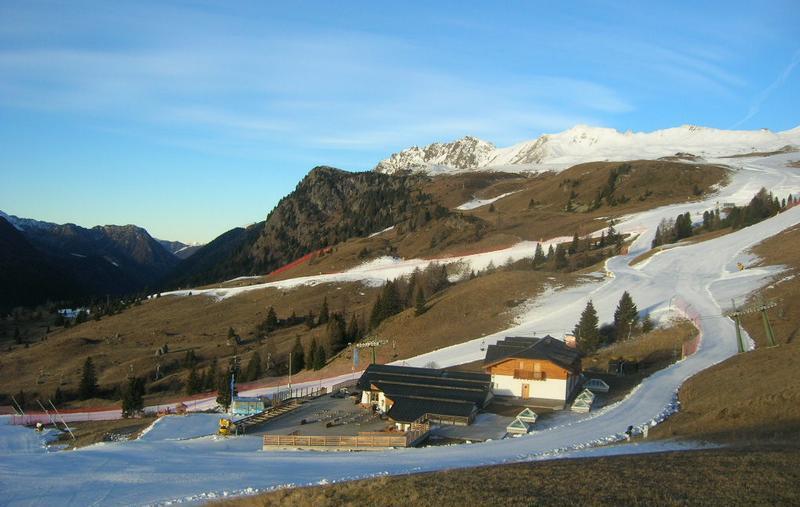 Snow-making in progress in the Dolomites. This is San Pellegrino – 2 December 2016 – Photo: dolomitisuperski.com
Updated: 9.55am Thursday 1 December 2016 - Continuing mostly settled
The weather in the Alps has settled down this week and will remain settled for quite some time to come, apart from a little snow in the extreme north-eastern Alps over the next 24 hours.
 Snow-making underway in Lech – 1 December 2016 – Photo: schmelzhof.at
The snow will be modest and mostly confined to the north-eastern Austrian Alps (e.g. St Wolfgang, Hinterstroder). For the vast majority of the Alps, however, there is no snowfall for the foreseeable future – that being 8-10 days at least.
Snow conditions in the Alps remain highly variable – still excellent at altitude in the west and south-west (e.g. Val d’Isère, Tignes, Val Thorens, Cervinia). By contrast, below about 1800-2000m natural snow cover is (with one or two exceptions) patchier or non-existent.
We say natural snow cover because snow-making is underway on an industrial scale, especially in the eastern Alps (e.g. Austria, Dolomites) where it is coldest this week. Further west, freezing levels are higher, but snow-making is also possible at times, especially at night.