

ARCHIVE
Today in the Alps - December 2015
Updated: 10.40am Thursday 31 December 2015 - Big snowfalls on their way, at least for the western Alps
A weak weather front will move from west to east across the northern Alps today, introducing more in the way of cloud than in recent days. There will also be some scattered light precipitation, with even a dusting of snow at altitude, but no significant accumulations.
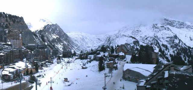 Cloudier this morning in Avoriaz with a dusting of new snow - Photo: avoriaz.com
The much anticipated “big change” in the Alpine weather pattern will come in three phases. Today, Phase 1 will see the passing of the weak cold front, which will introduce no more than a few centimetres of snow here and there to some northern parts of the Alps, first in the north-west (e.g. Avoriaz), then later in the north-east (e.g. Kaprun).
The rain/snow limit will start at around 1600m, but will lower later in the day as colder air moves through. Do not expect any significant snowfall from this first front, just a dusting here and there, with 5cm+ very locally close to the northern foothills. Except for the odd rogue shower, the southern Alps will stay dry.
Phase 2 will see a more potent storm arriving from the west on Friday night, influencing the Alps well into Saturday. This storm will bring significant snow to much of the French Alps (e.g. Alpe d’Huez), parts of western Switzerland (e.g. Verbier) and even western Italy, especially close to the French/Swiss border (e.g. Cervinia). The further east you go, however, the less important any precipitation will become, with the Dolomites in particular again missing most (if not all) of the action.
The rain/snow limit in Saturday’s storm may again start around 1500m, but should lower to closer to 1000m as the day goes on. Above 1800m we can expect 15-30cm quite widely across the French Alps (locally 40cm) and some parts of the western Swiss Alps. More generally in the Swiss Alps and north-west Italian Alps, we are likely to see 5-20cm. The Austrian and central & eastern Italian Alps will see less snow, with some places missing out altogether.
Phase 3 will see the “Atlantic conveyor” really opening up, with a series of storms slamming into the Alps from the west, starting on Sunday evening and continuing well into next week. The fine detail is still tricky at this stage, but this will bring a lot of snow to the western Alps, especially the northern French and western Swiss Alps.
Some milder air may be in the mix at times which means rain is possible low down, especially later in the week, but generally speaking there should be some impressive quantities of snow building at altitude. Once again snowfall will be less significant the further south-east you are, with the eastern Italian Alps (Dolomites) likely to see least of all.
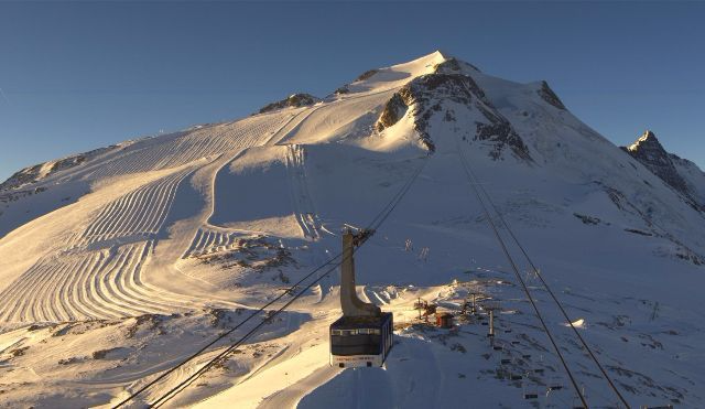
As for current snow conditions in the Alps, it won’t come as much of a surprise to hear that they remain very poor for late December. Cloudier skies in the north and west will only add to the general malaise, so we think that the brighter, southern Alps, especially southern Austria (pictured) and the Dolomites, will provide the most enjoyable skiing conditions today, even if the snow is almost entirely man-made.
 The drought continues in the south-eastern Alps. This is Turracher Höhe in southern Austria - Photo: turracherhoehe.at
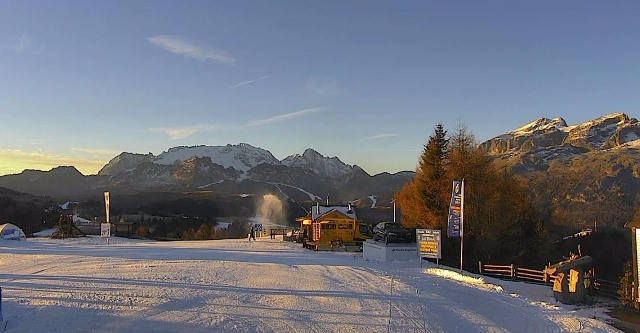
Updated: 10.45am Wednesday 30 December 2015 - Still mostly fine today but background pattern change continues
It’s another mostly fine day in the Alps (above any valley fog) but, behind the scenes, changes to the overall weather pattern continue, and we are still on for a number of snowfalls of varying intensities over the next few days.
 View from high above Montchavin-Les Coches (La Plagne) looking towards Mt Blanc with the Peisey-Vallandry ski area on the right - Photo: montchavin-lescoches.com
Note that the western half of the Alps will benefit most from the upcoming storms, with some eastern, and especially south-eastern areas (e.g. Dolomites), likely to see very little new snow.
Even yesterday, the first very weak weather front brought a few flakes of snow at altitude to the far western Alps. However, it didn’t make any progress east and soon died away, leaving most places dry.
The next front will reach the western Alps tomorrow (Thursday), and move eastwards into Austria early on Friday. This front will again be weak, affecting mainly the northern half of the Alps, with a rain/snow limit starting at around 1400-1700m but lowering towards 1000m later. We are only excepting 1-5cm of snow above 1500m generally, with 10cm+ very locally in the western foothills and the Jura.
The second storm, which will arrive on Saturday, will be a little stronger and mainly affect the south-western Alps - in this case the French Alps (both north and south), the western Italian Alps (e.g. Sestriere) and the south-west of Switzerland (e.g. Zermatt).
Snowfall totals are expected to be in the range of 5-20cm above 1500m, and perhaps 30cm+ in some favoured locations (e.g. Alpe d’Huez). The Austrian Alps, eastern Swiss and eastern Italian Alps will miss most (if not all) of the action from this particular storm.
Then, later on Sunday and into the first part of next week, things get really interesting with a more potent Atlantic storm slamming into the Alps from the north-west. Temperatures will fluctuate, so some rain is likely at low altitudes at times. Generally speaking, however, some significant quantities of snow are expected across the north-western half of the Alps, with the northern French Alps most in the firing line as things stand.
The south-eastern Alps (e.g. Dolomites) will miss the heaviest of the precipitation, as will parts of Austria, where the best chance of heavy snow will be in the west (e.g. Arlberg region).
For more on current snow conditions in the Alps please see Monday’s detailed country by country snow report.
 Plenty of snow forecast in Les Saisies over the next week, and not before time! - Photo: lessaisies.com
Updated: 10.30am Tuesday 29 December 2015 - First subtle changes underway
It’s another mostly fine day across Alps, but the first signs of a change in the weather are already underway. To the west we have an approaching cold front, which will bring some cloud to the far western Alps today. To the east, we have cold air beginning to filter into eastern Austria.
 High clouds above Méribel today, as the weak cold front approaches from the west - Photo: merinet.com
These two factors don’t seem hugely significant in themselves, but they do spell the beginning of the end of the exceptionally mild spell of weather that has led to December becoming one of, if not the warmest on record in the Alps.
The first snowfall will arrive on Thursday and Friday, affecting mostly the northern and western Alps with a rain/snow limit somewhere between 1000-1500m. Quantities will be fairly modest, perhaps 5-15cm above 1500m, but heavier, more widespread snowfalls are expected in the first week of January.
Back to the here and now, and snow conditions are exceptionally poor for late December across the Alps. As regular readers will know, the best natural snow cover is in the higher resorts of the northern and western Alps, such as L’Espace Killy, the Paradiski, Les 3 Vallées and Zermatt. However, even here the snow cover is very modest, there is also no off-piste to speak of, and the slopes are very crowded.
Resorts with most of their skiing below 2000m are heavily, or in some cases entirely, reliant on artificial snow. In the north-western Alps, conditions have not been conducive to consistent snow-making, which has left the likes of Morzine and Megève with only a tiny proportion of their ski areas open.
By contrast, the lower resorts of the southern and eastern Alps (e.g. Dolomites, Ski Welt, Saalbach-Hinterglemm) have succeeded in opening the majority of their ski areas almost entirely on artificial snow. This is partly down to better snow-making facilities, but also due to the drier climate (snow-making is more efficient in drier air).
So, with the major change in weather pattern now underway and significant snow expected in some parts over the next 7-10 days, things are at last looking up for the Alps. That said, we still need to guard against complacency as there is an awful lot of ground to be made up.
It will take several major snowfalls to get anywhere close to where we should be at this time of year, and some areas may yet be disappointed. More in our detailed snow forecast later today…
 A very green looking Kitzbühel valley - Photo: kitz.net
Updated: 9.50am Monday 28 December 2015 - Change is afoot
It’s another mostly sunny and exceptionally mild day in the Alps. However, it will be the last day for some time when freezing levels have any chance of surpassing 3000m.
 Hard-packed pistes on the return to Les Arcs, France - Photo: lesarcs.com
As of tomorrow (Tuesday), the weather in the Alps will start to turn colder, both from the east and the west, with the first light snow possible in the western French Alps as early as Thursday afternoon.
This weather front is then forecast to cross the rest of the Alps on Friday, with a little snow above 1000-1400m, mostly across the northern half of the Alps.
Looking a bit further ahead, the weather is expected to become more generally unsettled during the first week in January, with more significant snow possible in all regions.
It’s still too early to go into any sort of detail, but suffice it to say that most (if not all) of the available weather models are in broad agreement that a change in the weather pattern is imminent, and that most parts of the Alps are likely to see some useful snowfalls early in the New Year.
Unfortunately, this change in the Alpine weather will come too late to make much difference to New Year skiers, even if there is a little bit of fresh snow here and there by Friday. However, there will at least be plenty of sun this week, which should hopefully go a little way towards compensating for the serious lack of snow in the Alps right now.
Indeed, as expected, the New Year crowds have only exacerbated the problem with icy, stony conditions reported even in some higher French resorts, where natural snow cover is at its most abundant.
In some ways, given that any serious off-piste is out of the question, the best skiing is now on the lower, more pastural (grassy) slopes of the Austrian and Italian Alps, even if they are mostly or totally reliant on artificial snow. Certainly, looking at the many reports we have seen, rocks and stones seem to be less of any issue here than in the high resorts of the western Alps.
Whatever the case, take it easy if you are skiing in the Alps this week. The slopes are exceptionally busy and, with slick pistes, it is imperative that you ski/board within your means.
 A typical Austrian scene right now. This is St Johann im Pongau - Photo: sanktjohann.com
Updated: 11.45am Sunday 27 December 2015 - Winter edges closer
It’s good news for the Alps this morning as the weather models take another step towards colder and potentially snowy weather early in the New Year. Indeed, the first signs of change could be upon us as early as the middle of next week.
 More sunshine today in the Monte Rosa ski region, where snow is in desperately short supply - Photo: monterosa-ski.com
Back to the present, and it’s another sunny day for the Alps with freezing levels close to 3000m. It will stay mostly fine over the next few days, with the first weak weather fronts not approaching the western French Alps until the middle/end of this coming week. At the same time, much colder air will begin to filter into eastern Austria, with daytime temperatures struggling to get above freezing in Vienna as early as Wednesday.
Though this convergence of air masses will be the first sign of change, we will probably have to wait until the New Year for any significant action in terms of snow.
So while it remains tricky to pin down the timing and detail, the first week in January does look very interesting in terms of snowfall potential, with the southern and western Alps most in the firing line, as things stand. This could change, however, so stay tuned to our daily updates.
 Many of the lower Austrian resorts are heavily or completely reliant on artificial snow. This is Wargrain - Photo: skiamade.com
As for current snow conditions in the Alps, they remain very poor for late December with only a few ski resorts even close to being 100% open, and many heavily reliant on artificial snow.
The best natural snow remains in the higher resorts of the western Alps (e.g. Val d’Isère, Val Thorens), but even here it is thin and there is little off-piste to speak of. Lower down, and more generally across the southern Alps, it is often a case of thin strips of white criss-crossing green valleys.
Piste congestion is also becoming increasingly problematic now that we have entered New Year week. This, combined with the hard-packed and sometimes icy conditions, has led authorities to urge people to slow down and ski/board within their means.
Updated: 9.30am Saturday 26 December 2015 - Still spring-like, but pattern change is edging closer
The weather in the Alps will remain mostly fine and very mild until the middle of next week at least. Thereafter, it looks like it will slowly become cooler and more unsettled.
 Bluebird again in the Austrian Alps. This is the Zillertal arena - Photo: bergfex.com
However, what everyone really wants to know is when the Alps will next see significant snowfall? That is a question that is still impossible to answer right now, such is the volatility of the various weather models. What we can say, though, is that the prognosis for early January remains encouraging, even if some doubts remain over detail and timing.
Back to today, and it’s another sunny and exceptionally mild one in the Alps with freezing levels close to 3000m. As is the norm at this time of year it will often be warmer up the mountain than down in the valley.
Snow cover remains very feeble for the end of December, significantly below average in all regions, non-existent even at low altitude and across vast swathes of the southern Alps. That said, resorts have done an incredible job in getting as much open as they have. Nowhere is this better illustrated than in the Dolomiti Superski region, where they have 764km of pistes open almost entirely on artificial snow. Low Austrian resorts have also done an amazing job seemingly against the odds, with over half of the 186 runs in the Ski Welt open despite an upper base of no more than 25cm.
The best natural snow cover remains in the higher resorts of the north-western Alps, particularly in the French Tarentaise (e.g. Val d’Isère, Val Thorens, La Plagne). However, overcrowding on hard and/or icy pistes is now the biggest issue, a problem that will become more acute as numbers peak between 28-31 December.
The weather in the Alps should remain mostly fine until next Tuesday or Wednesday (at least). Weak weather fronts might then bring a little snow in places here and there, but we are not expecting any major snowfall in the Alps until early January, and even that is not quite a done deal yet.
Stay tuned!
Updated: 8.35am Friday 25 December 2015 - Winter on its way?
The most important question on everyone’s lips right now is when exactly will winter return to the Alps? And this morning we have good news, as the signals for change to the endlessly mild weather pattern grow stronger.
 Another glorious day in the Alps. This is the Grande Motte glacier in Tignes - Photo: tignes.net
It’s not a done deal yet, the weather models remain highly volatile and some professional bodies are still not buying into the idea that there will be any widespread or significant snow in the Alps any time soon.
However, it would be fair to say that the chances of a return to winter in early January are increasing – with some charts even suggesting that parts of the Alps will see snow as early as the middle of next week.
In the meantime, if you are lucky enough to be in the Alps right now, enjoy the fine weather but ski within your means! The snow is often quite hard and icy and the number of people on it will only increase, especially after Christmas.
Updated: 9am Thursday 24 December 2015 - No significant snowfall before the New Year
Most of the Alps will be sunny again today - just watch out for some high cloud drifting into the north-west at times. It will still be mild, but not excessively so compared to some recent days, with freezing levels around 2000-2500m.
 Another sunny day in the Alta Badia - Photo: dolomitisuperski.com
The question on everyone’s lips right now is when will it next snow in the Alps? We have been mentioning for some time that there is hope of a pattern change in early January. This is still the case (i.e. that there is hope), but unfortunately it’s not yet a done deal as there is simply no consistency with the various weather models.
There is even some uncertainty as to how the weather in the Alps will pan out for the last few days of this year. Although we can be fairly certain that there won’t be any significant snow, there is a possibility of some bits and pieces at altitude in the west from about 29 December onwards. After that, the picture is even more confused, but at least the models are now showing the possibility of change - it wasn’t that long ago that there was absolutely no sign of a change in pattern from any of the models.
Back to the present, and snow conditions in the Alps remain a big concern as we approach one of the busiest weeks in the skiing calendar. Keen skiers will no doubt be aware that people have been reporting some perfectly decent piste skiing in recent days. However, in times like these, enjoyment is highly dependent on two factors - the sun and a lack of crowds.
With a bit of luck we will still see plenty of the former over the next few days, although cloud cover will become much more variable as we approach the New Year. The latter, however, will become more of an issue, especially after 26/27 December.
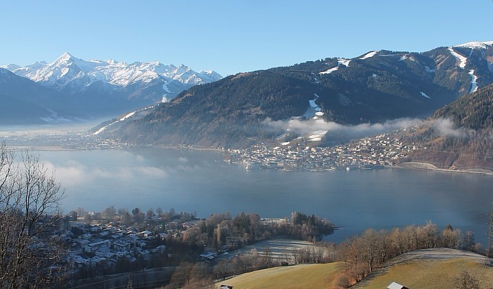
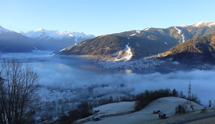 Early morning mist on the lake at Zell-am-See - Photo: foto-webcam.eu
The best snow conditions are in resorts with plenty of skiing above 2300m, such as L’Espace Killy, the 3 Valleys, the Paradiski, Verbier, Engelberg, Ischgl, Obergurgl and Sölden. Even here, though, the pistes are hard packed and icy in places. Lower down, most resorts are partially open but much more (and sometimes totally) reliant on snow-making, such as in the Dolomiti Superski area where over 700km of pistes are open entirely on man-made snow.
The resorts struggling the most are actually the lower ones of the western Alps, such as Morzine and Megève, where the more humid climate has made snow-making more of a struggle (at higher temperatures snow-making is easier when the air is very dry).
So all in all, the situation in the Alps is far from ideal as we hit the high season, with the biggest concern now being the increasing crowds competing for limited snow.
Alpine ski resorts have done an amazing job getting as many runs open as they have, but are now appealing for the public to take even greater than normal care - to keep their speed down and ski responsibly on increasingly hard and fast pistes. Needless to say there is no serious off-piste to speak of until we see some significant snowfall…
Updated: 9am Wednesday 23 December 2015 - Sunny but cooler
It’s another glorious morning in the Alps, with wall to wall sunshine, above any valley fog patches. A key difference from yesterday, however, is that it will be noticeably cooler at altitude, with freezing levels close to 2500m. Later in the day some high cloud will move into the far north-western Alps, but it will stay dry.
 Reasonable snow cover at high altitude still in the north-western Alps. This is La Plagne, France - Photo: la-plagne.com
Christmas Eve (Thursday) may see a little more cloud generally but it will again stay dry with decent spells of sunshine in many places. Christmas Day (Friday) itself should then be sunny again, above any valley fog patches, with freezing levels back up towards 3000m.
The weather in the Alps will stay very mild into the New Year with plenty of sunshine, especially in the southern Alps. There is also the chance of some showers, with a dusting of snow at altitude, for some western parts of the Alps around/after 29 December. However, we will have to wait until 3 January, at the very least, before there is any chance of any significant snowfall for the Alps. Even then, this is far from certain but there are hints of something more promising around this time.
As for current snow conditions in the Alps, they remain very poor (generally speaking) though, as always, there is some decent on-piste skiing still available if you know where to look. The best resorts right now are those with plenty of options above 2300m such as Val d’Isère, Tignes, Val Thorens, La Plagne, Arc 1950/2000, Verbier, Zermatt, Engelberg, Ischgl, Obergurgl and Sölden.
The resorts struggling the most are the low resorts of the north-western Alps such as Megève, Morzine and Villars, where not only is most of the skiing below 2000m, conditions have been less than conducive to snow-making on a consistent basis.
By contrast, many Italian resorts (e.g. Dolomites) have a decent range of pistes available despite little or no natural snow at all. This is partly due to their superior snow-making facilities but also because the climate is drier (less humid) here than on the north-western side of the Alps, and snow-making is easier in drier air.
Many low Austrian resorts (e.g. Söll, Saalbach) also have a surprising number of runs open, even if the situation is far from ideal.
So while there is plenty of on-piste skiing available across the Alps right now, there is still no getting away from the fact that this is another exceptionally poor start to the season. Furthermore, snow conditions are not going to get any better between now and the end of the New Year week.
As we mentioned earlier, there is hope of a major pattern change on or after 3 January, but that is a long way off in meteorological terms, and will need reaffirming over the next few days.
 Only patchy snow cover in Villars, Switzerland - Photo: villars.ch
Updated: 10.20am Tuesday 22 December 2015 - Exceptionally mild
Yesterday a weak weather front brought a little snow above 2000m to some north-western parts of the Alps. However, quantities were very modest, and lower down rain further eroded the meagre snow cover in areas such as Megève, the Portes du Soleil, Villars and Gstaad.
 Sunny again across the Alps today. This is Hochkönig - Photo: hochkoenig.at
Today, the sun is back (though it never really left some southern parts of the Alps), and it is exceptionally mild at altitude, with freezing levels in excess of 3500m! All this is not good news for snow conditions in the Alps, which continue to deteriorate in the run up to Christmas.
In most regions there is now very little natural snow below about 1600-1800m, and none at all across vast swathes of the southern Alps, which haven’t seen any serious precipitation since October!
The weather in the Alps will stay mostly dry and mild for the rest of the week, with no significant snow forecast within a reliable timeframe. There is hope of a change to the endlessly mild pattern towards the New Year, but the various models keep chopping and changing and, as yet, there is still no broad consensus as to what exactly is going to happen.
In the meantime, there is some decent skiing still available if you know where to look, with the best conditions in resorts with plenty of skiing above 2300m. Examples include L’Espace Killy, the 3 Valleys, the Paradiski, Verbier, Zermatt, Engelberg, Ischgl, Obergurgl and Sölden.
As we have already mentioned, the southern side of the Alps (which includes Italy) has little or no snow, but many resorts here (especially in the Dolomites) have used their considerable snow-making capabilities to open a surprising number of pistes. This is also true for many of the lower Austrian ski resorts, though high temperatures are interfering with the operation of the cannons at times.
Snow-making has been more problematic generally in the lower resorts of the north-western Alps, where it has been even milder and more humid (cannons work best in cold dry air, and worst or not at all in mild humid air). This is graphically illustrated by the plight of Morzine (pictured) that has struggled to lay even an artificial base and is now virtually snowless.
 Virtually no snow left in Morzine - Photo: chilloutmountain.com
Updated: 9.10am Monday 21 December 2015 - Another dusting possible at altitude in the north-western Alps
A weak cold front will bring a dusting of snow to some north-western parts of the Alps today, but only above 1800m or so, and most regions will stay completely dry.
 View from the top of St Anton’s Valluga this morning, where it is expected to cloud over as the day progresses - Photo: stantonamarlberg.com
We are expecting no more than 1cm to 5 cm of new snow above 2000m in the northern French Alps, mostly in the Haute-Savoie (e.g. Chamonix) and the north-western Swiss Alps (e.g. Glacier 3000). Some other northern parts of the Swiss Alps (e.g. Engelberg) and the far west of Austria (e.g. Lech) may also see a dusting at altitude later in the day, but no more than that. The best of any sunshine will be in the southern Alps, parts of which have not seen any precipitation at all since October!
The weather in the Alps will remain on the mild side for the rest of this week. There will also be plenty of sunshine, with just a few areas of cloud drifting around from time to time.
No significant snow is forecast for the Alps for eight days at least. Beyond that, some weather models are suggesting that the situation could start to turn in our favour as we approach the New Year. However, this is still a long way off, there is little broad agreement between the models and it is too early to be getting our hopes up just yet.
Back to snow conditions in the Alps and you may have heard some conflicting messages across social media in the last few days. Given the fine weather and relative lack of crowds, many people have been reporting some perfectly enjoyable on-piste skiing. These two factors are absolutely crucial in determining your skiing experience in times of little snow.
The good news is that the Alps will continue to enjoy plenty of good weather over the next week, although there will be cloudier interludes at times, not least across the north-western Alps today when there will even be a little light rain/snow in places. The bad news is that it will become increasingly crowded, especially after Christmas, which will crank up the pressure significantly.
Potential crowding issues aside, the best natural snow cover remains at altitude in the north-western half of the Alps, and the best resorts are those with plenty of skiing above 2300m such as L’Espace Killy, the 3 Valleys, the Paradiski, Verbier, and Ischgl - to name just a few. Lower resorts such as Morzine, Megève and Villars, however, are really struggling.
The southern Alps have very little natural snow, and in many cases none at all. However, state-of-the-art snow-making has allowed a surprising number of runs to open here. Nowhere is this better illustrated than in the Dolomites, where 691km of runs are now open in the Dolomiti Superski area (Selva, Arabba, Cortina etc.) almost entirely on artificial snow.
Many low Austrian resorts (e.g. Ski Welt, Saalbach) are also heavily dependent on the man-made stuff, but have done an admirable job in opening up a good proportion of their area.
If it’s powder you’re after, the resorts of western Canada and the US are the places to be. More on that in our detailed snow report later today…
 No natural snow in the Dolomites, but still lots of skiing thanks to state-of-the-art snow-making! This the Val di Fassa - Photo: dolomitisuperski.com
Updated: 9.15am Sunday 20 December 2015 - Another glorious day for the Alps
Today will be another mostly sunny and exceptionally mild day, with freezing levels in excess of 3000m. Tomorrow, a weak weather front will bring a dusting of snow above 2000m to some north-western parts of the Alps, but once again it won’t change the overall situation.
 View from the Mölltal glacier this morning - Photo: www.gletcher.co.at
So we can say with certainty that there won’t be any significant snowfall in the Alps before the start of the New Year week (26/27 December). Some models do hint at a change towards New Year itself, but this is little more than speculation at this stage.
As for current snow conditions in the Alps, there is still some enjoyable piste skiing to be had, if you know where to look and can avoid the increasing crowds.
The vast majority of ski resorts are at least partially open, though many are heavily reliant on artificial help. The best natural snow cover remains at altitude across the north-western half of the Alps, e.g. L’Espace Killy, 3 Valleys, Paradiski, Verbier, Engelberg.
By contrast, most Italian resorts (e.g. Dolomites) have little or no natural snow, and are almost entirely dependent on snow-making. The same goes for some low resorts further north, especially in Austria.
Updated: 1pm Saturday 19 December 2015 - Spring-like this weekend in the Alps
It may be the start of the Christmas holidays, but winter seems as far off as ever in the Alps today, with virtually wall to wall sunshine, at least above any valley fog patches.
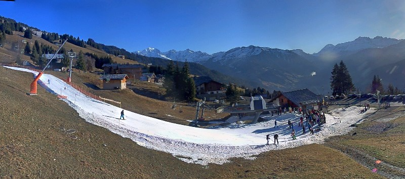
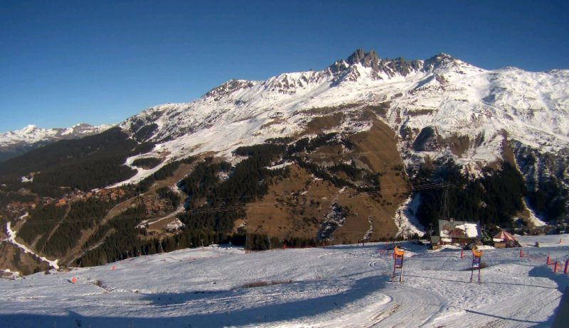 119 of the 169 pistes are open in the 3 Valleys today, despite the modest snow cover. This is Méribel - Photo: merinet.com
As is the norm under high pressure at this time of year, it is often much warmer up the mountain than it is in the valley bottom. The shade temperature in Chamonix today, for example, is likely to peak at about 7°C, the same as the shade temperature up at 2500m. Indeed freezing levels could be as high as 3500m in many western parts of the Alps this weekend.
Looking further ahead and, except for a few light showers close to the northern fringes of the Alps on Monday, much of the coming week will remain dry and very mild.
In yesterday’s Alpine forecast, we did talk about the slim possibility of some snow for the southern and western Alps around 27 December, but this has all but disappeared from today’s charts and we now face the very real possibility of no significant new snow until the New Year.
As for current snow conditions in the Alps, there is still plenty of decent on-piste skiing to be had, but the general situation is a concerning one. It remains to be seen how resorts will cope with the sharp increase in traffic.
The best conditions are in high resorts with plenty of slopes above 2300m, particularly (but not exclusively in the north-western Alps). Examples include Val d’Isère, Tignes, the 3 Valleys, Paradiski, Verbier, Zermatt, Engelberg, Ischgl and Sölden.
By contrast, nearly all Italian resorts, as well many low resorts further north have little or no natural snow at all and are heavily reliant on artificial help. Nowhere is this better illustrated than in the Dolomiti Superski area (Selva, Corvara, Cortina etc.) where 679km of pistes are now open, almost entirely on man-made snow.
Updated: 9.20am Friday 18 December 2015 - Still no major snowfall in sight
The weather in the Alps will continue very mild for the foreseeable future. We can also say with certainty that there will be no significant new snow before Christmas, and quite possibly for some time after.
 A scene typical of the Alps right now, with some snow high up but the lower valleys mostly green - Photo: heiligenblut.at
Yesterday was a mini powder day for a few lucky ski resorts across the northern and north-eastern Alps - as seen in the photo below, sent in to us from St Anton, where there was 15cm of fresh high above the resort. However, it won’t have done much to change the overall situation, and the lack of snow in the Alps remains a serious concern for many as we approach peak season.
 Mini powder day in St Anton yesterday - Photo: Mark Shaw
Today, areas of high cloud will blot out the sun from time to time, but it will stay mostly dry with the best of the sunshine in the south. Freezing levels will range from about 2400m in the north-eastern Alps to close to 3000m in the south-western Alps.
The weekend promises to be gloriously sunny and exceptionally mild, with freezing levels in excess of 3000m in most places. On Monday, a very weak weather front may bring the odd shower (and a few flakes of snow above 2000m) to the northern foothills of the Alps, but the vast majority of regions will stay dry and very mild with plenty of sunshine.
As for current snow conditions in the Alps, there is still some very enjoyable skiing to be had, if you know where to look - though serious off-piste possibilities remain very limited.
The higher resorts of the northern and western Alps remain the places to be for the best combination of snow quality and variety of pistes on offer. Examples include (but are not limited to) Val d’Isère, Tignes, Val Thorens, Les Arcs, La Plagne, Verbier, Zermatt, Engelberg, Ischgl and Sölden.
At low altitude and on the southern side of the Alps there is little or no natural snow, but here too most resorts are partially open thanks to extensive snow-making. Saalbach in Austria, for example, has 50 lifts open on a meagre 30cm upper base. Perhaps even more impressive, the Dolomiti Superski area (Sella Ronda, Cortina etc.) has opened 559km of pistes, almost entirely on artificial snow.
So it’s not all doom and gloom, but we still cannot escape the fact that snow conditions in the Alps (as a whole) are exceptionally poor for mid-December, and won’t be improving any time soon.
You can get away with it to a point when all is quiet, but the acid test will be what happens during the festive rush, especially from 26 December onwards.
Check out our more detailed weather forecast for the Alps later today…
Updated: 9.20am Thursday 17 December 2015 - A little fresh snow at altitude in the north and east, but still mild
The northern Alps have seen a little new snow in the last 24 hours, but only at altitude, and the mild weather is set to continue until Christmas and beyond.
 Some fresh snow at Stand above Engelberg - Photo: titlis.ch
This morning there are still some showers across the central and eastern Austrian Alps (snow 1800m), but these will disappear eastwards as the day progresses.
Most other parts of the Alps will be dry with variable cloud and the best of the sunshine in the west, where freezing levels will be as high as 3000m.
Fresh snowfall totals over the last 24 to 36 hours have been modest, generally 2-5cm above 2000m in the northern French Alps, and 5-20cm (locally a bit more) in the Swiss and Austrian Alps (away from the far south). Lower down, light rain has further eroded the meagre snow pack, and the southern Alps have again seen little or no precipitation.
 The faintest of dustings for Kronplatz in the Dolomites, but essentially the snow drought continues - Photo: foto-webcam.eu
The weather in the Alps will now remain very mild until Christmas and beyond. It will often be fine, but weak fronts will occasionally flirt with the northern Alps giving a little light rain/snow at times. Generally speaking, snow conditions will continue to deteriorate.
Back to the here and now, and if you are lucky, you could catch a little powder in some of the higher slopes of the northern and eastern Alps (e.g. in Engelberg, St Anton, Ischgl, Kaprun). However, the benefit of this recent weather system will be relatively short lived.
Generally speaking, if you are looking for the greatest variety of open pistes in the best possible condition, you need to head to the higher resorts of the northern and western Alps such as Val d’Isère, Tignes, Val Thorens, La Plagne, and Zermatt.
For a perspective on how things stand right now across the Alps, see our latest season progress report.
If you are wondering where all the snow has gone, then western USA and Canada are the places to be. More on this in our detailed snow report later today...
Updated: 9.15am Wednesday 16 December 2015 - Still mild, but a little fresh snow here and there…
It’s still mild today, but there is a temporary change in the weather as weak fronts cross the Alps, bringing some rain and a little snow here and there, mostly to the north and north-east.
 3cm of fresh snow in Val d’Isère this morning - Photo: valdisere.com
The rain reached the northern French and western Swiss Alps early last night with a little snow above 2000m - lower in some of the internal valleys (e.g. Val d’Isère). It then moved west across many other parts of Switzerland to reach western Austria first thing this morning. The rain/snow limit is a little lower here (1600-1900m), with freezing rain (where rain freezes on coming into contact with cold ground) also reported in some of the enclosed valleys.
Today, we can expect this rain/snow to move further east to affect other parts of the Austrian Alps (except Carinthia), while it brightens up further west. Once again, most southern parts of the Alps will stay dry.
As expected, snowfall totals from this storm are/will be modest. We have seen 1-6cm above 2000m across the northern French Alps (e.g. Val d’Isère), where the precipitation has now more or less stopped. In the northern and western Swiss Alps (e.g. Verbier, Mürren) there has been 5-15cm at altitude.
In the Austrian Alps, it has either only recently started snowing or hasn’t started at all yet, but we can expect 5-20cm above 2000m in the west (e.g. Ischgl), a few centimetres here and there further east, but next to nothing in the south (Carinthia).
 Red sky in the morning, shepherd’s warning! The Tux valley this morning before the expected light rain/snow moves in - Photo: foto-webcam.eu
In short, while there is a little bit of powder at altitude here and there this morning, it won’t do much to change the overall picture and the mild weather pattern is set to stay with us until after Christmas.
So, snow conditions in the Alps remain less than ideal as we approach high season. As we have been at pains to point out though, this doesn’t mean that it is all doom and gloom.
Natural snow cover is still half reasonable at altitude in the north-western half of the Alps (e.g. Val d’Isère, Tignes, Val Thorens, Verbier, Laax, Engelberg). And in areas where there is little or no natural snow (e.g. the Ski Welt in Austria and Dolomites in Italy), they have done a fabulous job opening up a decent number of runs purely on artificial snow
However, we cannot disguise the fact that there is a serious shortage of snow in many parts of the Alps right now, with no sign of a proper reprieve any time soon.
Updated: 9.45am Tuesday 15 December 2015 - A little snow at altitude for some tonight/tomorrow
The mild weather continues, and will continue for the foreseeable future. A warm front will bring a little snow at altitude tomorrow to some northern parts of the Alps (especially Austria), but it won’t significantly change the bigger picture, and the south will again stay dry.
 View towards Morzine from Avoriaz this morning - Photo: avoriaz.com
Back to today, and it is a bright start across much of the Alps, though there are areas of high cloud drifting around making any sunshine hazy at times. Cloud will thicken up more generally across the northern Alps later in the day, heralding the arrival of the warm front tonight.
Rain will reach the northern French and Swiss Alps later this evening, spreading east to reach the far west of Austria by dawn. The rain/snow limit is expected to start at around 2000-2200m in the northern French Alps, 1600-1900m further east, perhaps even lower for a time in some of the colder enclosed valleys.
Tomorrow, any showers will quickly die out from the northern French and western Swiss Alps, but will continue further east and spread across other parts of Austria (away from the south), with some snow above 1900m.
Snowfall totals in the west will be negligible with just a few centimetres at best above 2200-2400m in the French Haute Savoie (e.g. Flaine) and the western Swiss Alps (e.g. Verbier). Further east, from about Engelberg eastwards into western Austria (e.g. St Anton), 10-20cm is possible above 2000m, locally a bit more, but lower down there will mostly be rain. The southern Alps will again miss the bulk of the precipitation.
 Some context on just how little snow there is in the south-eastern Alps. This is Mörtschach in Carinthia, Austria - Photo: foto-webcam.eu
So all in all, only a small number of ski resorts will see any tangible benefit from this weather front, namely those with plenty of skiing above 2000-2200m in the north-eastern quarter of the Alps - such as Engelberg, Davos, St Anton, Ischgl and Sölden.
As for the longer term forecast, the last of the showers will clear away from Austria on Thursday, then the weekend looks set to be mostly fine and again exceptionally mild at altitude. The weather in the Alps is then likely to remain mild all the way up to Christmas.
As for snow conditions in the Alps, regular followers of weathertoski will already know that snow depths are below average across the board. The areas doing best right now are the higher resorts of the northern and western Alps (e.g. Val d’Isère, Tignes, Val Thorens).
The areas with the least snow are the southern Alps (most of Italy), as well as the lower Austrian resorts, but all these regions have been working hard on their artificial snow cover, with considerable success.
The concern with the weather over the next 48 hours is that the increase in humidity will accelerate the thaw below 2000m, especially in the northern Alps.
At this time of year, when the pressure is very high and the air is dry (low dew points) snow melt will tend to be minimal, even when freezing levels are elevated. It is high dew points/humidity (and of course rain) that cause the most damage to the snow, rather the high temperatures per se.
Updated: 9.20am Monday 14 December 2015 - Endlessly mild!
We are looking at another very mild week of weather in the Alps. A little snow is expected at altitude in the northern Alps mid-week (mostly in Switzerland and Austria), but quantities will be modest and there will be little change in the overall picture.
 Very little snow at low altitude in Austria. This is St Johann im Pongau - Photo: sanktjohann.com
Looking further ahead, and it is now difficult to see how there will be any significant snow in the Alps before Christmas. This isn’t great news for anyone of course, but is of particularly concern to the low altitude resorts, and those in the southern Alps, where many regions have no natural snow at all.
Glaciers aside, the best snow conditions are in the higher resorts of the northern and western Alps such as Val d’Isère, Tignes, Val Thorens, La Plagne and Zermatt. However, thanks to artificial help, there are literally hundreds of ski resorts open across the Alps right now, even at low altitude in Austria (e.g. Saalbach, Söll), and in the snowless central and eastern Italian Alps (e.g.Selva), where there is nothing more than thin white strips amid the green fields.
In short, the situation is not ideal. Snow depths are considerably below normal for mid-December, there is little or no off-piste to speak of, and there are no significant snowfalls in the forecast. However, there is still some enjoyable on-piste skiing to be had, the best of which is at altitude in the north-western half of the Alps.
 Very patchy cover still in the southern French Alps. This is Serre Chevalier - Photo: serre-chevalier.com
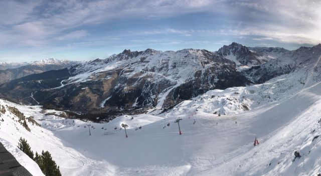
 The best snow is at altitude in the north-western Alps, but even at 2700m in Tignes the cover is looking thin - Photo: tignes.net
Updated: 10.45am Sunday 13 December - Another mostly fine day in the Alps
It’s another mostly fine day in the Alps, though there are some areas of high cloud drifting around, especially in the west. The next snow event is forecast for Wednesday and Thursday, but will be extremely modest and do little to change the overall picture.
 A typical scene in Austria, with some snow at altitude but plenty of greenery lower down. This is Pass Thurn near Kitzbühel - Photo: foto-webcam.eu
For anyone fortunate enough to be skiing in the Alps yesterday, snow conditions were really quite good. Granted, off-piste opportunities are extremely limited right now, but with very dry air (low dew points) snow quality on the piste was surprisingly high, despite the relatively elevated freezing levels.
That’s not to say we shouldn’t be concerned about the bigger picture - snow depths are below average everywhere for mid-December, and vast swathes of the southern Alps have no natural snow at all. However, we think is important to stress that there is some perfectly good skiing to be had right now, so long as you don’t have any serious off-piste or powder aspirations!
Literally hundreds of resorts are at least partially open across the Alps, though in the south this means skiing largely (or wholly) on artificial snow. In the Dolomiti Superski area, for example, they have managed to open 273 of their 460 pistes, testament to the extraordinary snow-making capabilities in this region.
Even on the snowier north side of the Alps, snow-making has played a big part in helping resorts to open, especially lower down and in the east (Austria) where thin strips of white amid green fields are the norm.
The best snow conditions remain in the higher resorts of the northern and western Alps, such as Val d’Isère, Tignes, Val Thorens, Engelberg and Zermatt. The least snow, as we have already mentioned, is on the southern side of the Alps, especially in the central and eastern Italian Alps (e.g. Dolomites), but remember that these are the areas with some of the best snow-making in Europe.
So will it snow again in time for Christmas?
The short answer is probably yes, but in what quantities remains uncertain. The first disturbance in the weather will arrive on Wednesday and Thursday, but will probably amount to no more than a few cm of snow here and there above 1800m.
Thereafter, the situation remains much more uncertain. Most of the weather models are still toying with a return to much more unsettled conditions in the run up to Christmas, which could mean significant snow for the Alps. However, it is still far too early to confirm this with any degree of certainty and so the waiting game must go on for a few days yet…
Updated: 7am Saturday 12 December 2015 - The wait continues
Except for some areas of cloud in the far north-eastern Alps (mostly to the east of Salzburg), skies are generally quite clear in the Alps first thing this morning.
 Dawn at the Sonnblick Observatory in Austria - Photo: Sonnblick.net
We are therefore expecting another glorious day for most regions, with lots of sunshine and freezing levels ranging from 2000m in the north-east to 3000m+ in the south-west. Temperatures will often be inverted, so that it will be warmer up the mountains than in the bottom of the valleys.
The weather will stay mostly dry and relatively mild over the next few days. Weak weather fronts may bring the odd shower to some northern parts Alps mid-week, but we are not expecting any significant or widespread snow any time soon. This morning’s weather models do bring some hope of a change around 21-22 December, but that is still a long way off and needs to be treated with the utmost caution.
Snow conditions in the Alps remain poor for the middle of December with below average depths across the board. That’s not to say you can’t still have fun - there is some perfectly decent on-piste skiing to be had, particularly in the higher resorts of the north-western Alps. However, if it’s powder or serious-off-piste you are after, forget it for now.
Our pick of resorts for the greatest extent and variety of runs at the moment are Val d’Isère, Tignes, Val Thorens, Zermatt and Ischgl, all of which have access to over 100km of pistes. However, there are literally hundreds of partial openings across the Alps this weekend, including many in the southern Alps where resorts are mostly reliant on artificial snow.
If you are desperate for powder, then the western US and Canada remain the places to be.
Updated: 7.35am Friday 11 December 2015 - Still no sign of winter
There’s another fine day in store for the Alps, with plenty of sunshine and freezing levels close to 2500m. It will stay mostly fine over the weekend, with just a little nuisance value cloud grazing the north-eastern Alps on Saturday.
 Lots more sunshine in the Alps today. This is Bad Kleinkirchheim - Photo: badkleinkirchheim.at
This morning’s medium term weather charts make grim reading. There is still the prospect of a little snow around the middle of next week, but only at altitude, and certainly not enough to affect the bigger picture to any significant degree.
A more general breakdown of the weather is then possible towards the weekend of 19/20 December but this is a long way off and still far from convincing. One thing we can be sure of is that temperatures in the Alps will remain above average for the next week at least.
Now for some positives. If you are lucky enough to be skiing in the Alps this weekend there will be plenty of sunshine to be enjoyed. The best snow conditions and greatest variety/extent of pistes remain in the higher resorts of the northern and western Alps such as Val d’Isère, Tignes, Val Thorens and Zermatt.
Lots of other ski resorts are partially open, even in the southern Alps, where they are often completely reliant on artificial snow. However, you can forget any serious off-piste for the moment.
If it is powder you want, then North America is the place to be. Whistler has had well over 1m of new snow at altitude over the last week and now California is getting walloped too.
Updated: 9.20am Thursday 10 December 2015 - The sun is back after a little fresh snow in the north
As expected, we saw a little snow across the northern Alps yesterday, 2-8cm above 1500m generally, with 15cm very locally in the north-eastern Swiss Alps. The southern Alps remained dry. Today, there is a little fog in some of the lower valleys, otherwise all regions can expect lots of sunshine, with freezing levels between 2500 and 3000m.
 The sun is back in the northern Alps today. This is Damüls in the Austrian Vorarlberg - Photo: damuels.at
Yesterday’s little snowfall might have temporarily freshened up the pistes in resorts such as Avoriaz, Engelberg and Lech, but it hasn’t really changed the overall picture, especially as about 80% of the Alps missed it altogether.
Except for a very weak weather front that might graze the extreme north-eastern Alps on Saturday, we now have another run of dry, mostly sunny and quite mild days to look forward to.
This takes us up until Tuesday, at which point weather fronts may bring some snow to parts of the Alps (especially the north). However, the weather models are constantly chopping and changing, and there is still quite a lot of uncertainty - even more so over what happens thereafter. Either way, a serious return to winter is still proving very elusive.
Snow conditions in the Alps are obviously not ideal for the middle of December, but there is still some enjoyable on-piste skiing to be had, especially in the higher resorts of the northern and western Alps.
The resorts we would pick to head to right now are Val Thorens, Val d’Isère, Tignes and Zermatt. These will offer you the greatest extent and variety of pistes. However, there are lots of other partial openings, even in the southern Alps, where they are relying almost entirely on artificial snow.
For further details, check out our full snow report later today…
 Impressive snow-making in the Sella Ronda region - Photo: Centro Meteo Dolomiti
Updated: 9.15am Wednesday 9 December 2015 - A dusting of snow for some northern parts of the Alps
A little snow will fall across some northern parts of the Alps this morning, but it won’t amount to very much, and the southern Alps will again stay dry.
 Light snow is falling this morning close to the German/Austrian border. This is Brauneck - Photo: brauneck-bergbahn.de
First thing this morning there is a little patchy rain (snow 1300m) in the far northern French Alps (e.g. Portes du Soleil), northern and western Switzerland (e.g. Verbier, Engelberg) and the far west of Austria (e.g. Lech).
These showers will spread further east into other parts of northern Austria later today (where the rain/snow limit could dip below 1000m), while dying away from the northern French and western Swiss Alps. The southern Alps will again stay dry with spells of sunshine.
Generally speaking, snowfall totals will be very modest – just 1-3cm above 1500m in the French Haute-Savoie, next to nothing for most of the Savoie, and 2-10cm in the northern Swiss and northern and western Austrian Alps (very locally a bit more). There will therefore be very little change to the overall snow situation in the Alps.
Thursday and Friday will be mostly fine and again relatively mild. Another very weak front may graze the north-eastern Alps over the weekend but again won’t be of any consequence.
The weather in the Alps is still uncertain for next week but it will undoubtedly begin with a mild south-westerly airflow. Some precipitation is then likely on Tuesday and Wednesday, especially in the west, but significant snow is still not expected at this stage.
As for current snow levels in the Alps, only a small area south of Lucerne in Switzerland (around and to the north of Engelberg) now has close to average snow depths for the time of year. Snow levels everywhere else in the Alps are below average, with hardly any snow at all across large parts of the south (i.e. Italy).
That said, people have been reporting some perfectly enjoyable piste skiing this week, some of the best of which has been in Val d’Isère, Tignes and Val Thorens in France, and Zermatt in Switzerland.
Lots of other resorts are also partially open - even in the southern Alps, thanks to artificial snow - but any serious off-piste is out of the question for the time being.
 Still bone dry in the southern Austrian Alps. This is Bad Kleinkirchheim - Photo: badkleinkirchheim.at
Updated: 9.35am Tuesday 8 December 2015 - A little snow for the northern Alps tonight
After a mostly fine day today, a weak cold front will bring a little snow to the northern Alps tonight. The good news is that this front is slightly more active than first projected a couple of days ago. The bad news is that any snowfall from it still won’t greatly change the overall picture, and the southern Alps (including Italy) will continue to miss out.
 Not much snow at low altitude in the northern Austrian Alps. This is Pass Thurn near Kitzbühel - Photo: foto-webcam.eu
Back to today and there are a few areas of cloud around this morning, but also plenty of sunshine. Later in the day, cloud will thicken more generally from the north, heralding the approach of the front.
Tonight, some mostly light precipitation will affect the northern half of the Alps, lingering in places tomorrow (especially in the north-east), while the southern Alps (including most of Italy) stay mostly dry. The rain/snow limit will start around 1700m but fall to 1000-1400m later.
Snowfall totals are expected to be modest - generally 2-10cm at 1800m, but perhaps 15cm+ in a few favoured spots such as the north-eastern Swiss Alps. Either way, though, this won’t significantly affect the overall snow situation in the Alps.
Looking further ahead and there is still lots of certainty as to how things will pan out over the next 10 days or so. One thing is for sure, we are much less likely, than we were a few days ago, to see a proper return to winter any time soon.
Yes, there may be bits and pieces of snow here and there, but those game-changing dumps (particularly for the southern Alps) remain elusive and the waiting game continues.
As for current snow conditions in the Alps:
The southern Alps continue to have very little natural snow though there are plenty of partial openings here, thanks to the vast quantities of man-made snow laid down during the cold spell at the end of November.
The best skiing conditions right now are in the higher resorts of the northern and western Alps, such as Val d’Isère, Tignes, Val Thorens and Zermatt. Check out our latest detailed snow report.
 Just to prove it’s not all doom and gloom! Plenty of snow at altitude in Les Arcs - Photo: lesarcs.com
Updated: 9.20am Monday 7 December 2015 - Another beautiful day in the Alps
There’s another beautiful day in store for the Alps, with almost wall to wall sunshine (above any lowland fog patches) and freezing levels close to 2600m. But, the most important question on everyone’s lips right now is when will it next snow in the Alps?
 Beautiful weather in the Austrian Alps today, but more snow would be welcome. This is Zell-am-See - Photo: foto-webcam.eu
Regular followers of weathertoski will know that for some time we have been talking about a possible return to winter in the Alps mid-month. However, over the weekend the situation has become much less clear cut, and this morning’s various weather models still show huge differences in the possible outcome over the next 7 to 10 days.
Looking at the short term first, and a weak weather front is expected to bring a little snow across some northern parts of the Alps mid-week. However, it won’t amount to very much, and many places (especially the southern Alps) will stay completely dry.
However, towards next weekend and thereafter, the models are so split there seems little point in speculating. Some forecasts suggest a little snow for the northern and eastern Alps on Saturday, while others show high pressure completely in charge, which means further dry and mostly sunny weather. It does, however, seem unlikely that we will see any significant snowfall before 15-16 December at the very earliest - possibly much later.
As for current snow conditions, glaciers aside, cover is still quite good in the north-western half of the Alps, even if snow quality has deteriorated somewhat in the last few days.
Among the best options right now are Val d’Isère, Tignes, Val Thorens and Zermatt, though it is highly advisable that you remain on-piste. Serious off-piste opportunities will remain few and far between until we have more snow.
Generally speaking, the southern Alps (including most of Italy) have very little natural snow. However, even here, there are plenty of openings thanks to their state-of-the-art snow-making facilities.
So where does have all the snow right now? Well, there has been plenty falling on the other side of the pond, notably in the Pacific North-West (e.g. Whistler), but more about that in our detailed snow report later today.
Updated: 3.10pm Sunday 6 December 2015 - Still mostly fine
High pressure is firmly in charge of the Alps and will remain so for much of the coming week. This means plenty of fine dry weather, with just the chance of a few showers across the northern Alps mid-week.
 Another beautiful day in Ischgl, Austria - Photo: Ischgl.at
So the question on everyone’s lips right now is when will it snow again in the Alps? Regular followers of weathertoski will know that we were optimistic last week that winter would return around the middle of the month.
Unfortunately, this isn’t looking quite so clear cut now. A pattern change is still on the cards, but it looks like being a gradual one and we are still a long way off translating this into significant snowfall for the Alps.
As for current snow conditions, cover is quite good in the northern and western Alps, even if snow quality has deteriorated somewhat in the last few days.
Among the best options right now are Val d’Isère, Tignes, Val Thorens and Zermatt, though most of the fun to be had is on-piste. Serious off-piste opportunities are few and far between until we have more snow.
The southern Alps have very little natural snow, but there are also plenty of partially open resorts thanks to made-made efforts.
Updated: 8.25am Saturday 5 December 2015 - Mostly fine and mild
A very weak weather front passed through the Alps last night. Most places stayed completely dry, but there was a dusting of snow above 1800m here and there. Today the cloud will break up again to leave a mostly sunny and relatively mild day.
 Another mostly fine day in the Alps, this is the Tux Valley in Austria - Photo: foto-webcam.eu
The weather in the Alps will remain mostly dry next week with plenty of sunshine and relatively mild temperatures. We still have our eyes on a pattern change next weekend that will hopefully bring something more wintry, but it is still too early to go into any sort of detail.
Snow conditions have deteriorated in the last few days due to the very mild weather, but there is still some decent piste skiing to be had, especially in the higher resorts of the northern and western Alps (e.g. Val d’Isère, Tignes, Val Thorens, Zermatt, Verbier, Engelberg). Decent off-piste opportunities are extremely limited.
Many more resorts are opening today, including some of the big Sella Ronda names such as Selva, Corvara and Arabba, almost entirely on man-made snow. On the other side of the Alps, Méribel, Courchevel, Avoriaz and Les 2 Alpes are just a few of the ski resorts that will join them.
Updated: 9.15am Friday 4 December 2015 - At least another week with no significant snow
High pressure is still dominating the weather in the Alps. However, a very weak weather front will move in from the north-west later today, with a few light showers here and there this evening and overnight.
 Bright start in Tignes, but high cloud can already be seen spreading in from the north-west - Photo: tignes.net
Friday itself will start bright (and remain so in many places), but cloud will increase in the north-western Alps as the day progresses. It will be a little cooler than of late with freezing levels between 2400m and 2700m in the west, a little higher further south and east.
This evening and overnight, a little light precipitation will affect some western parts of the Alps - perhaps parts of western Austria too. However, it won’t amount to much - just a dusting of snow here and there above 1800m, and most regions will stay completely dry.
The weather in the Alps will remain mostly dry and relatively mild next week, with just a chance of a few light showers in some northern regions mid-week. So we are looking at next weekend at the very earliest before there is any chance of a proper return to winter in the Alps.
It’s still a long way off, but the weather models have been fairly consistent in recent days in showing a blast of much colder more unstable polar air coming in from the north or north-west around the middle of the month. Fingers crossed.
As for snow conditions in the Alps…
Snow cover is still generally quite good across the north-western Alps. By that we mean the northern French Alps (roughly from Les 2 Alpes/Alpe d’Huez northwards), and the northern and western Swiss Alps (roughly north and west of a line from Zermatt across to Andermatt and Flumserberg).
Snow depths in these areas are not far off normal for the beginning of December, slightly above even in parts Switzerland (e.g. Engelberg, Mürren). As with most of the Alps, off-piste opportunities are limited, but with good local knowledge it is still possible to find pockets of light powder on north facing slopes here and there. We stress though that, generally speaking, off-piste skiing is not advised at this time.
Snow cover is more erratic in Austria. Glaciers aside, you need to either find a resort with plenty of slopes above 2300m (e.g. Obergurgl, Ischgl) or consider the Arlberg region (St Anton, Lech), where you can get away with being a bit lower than this. Either way, we are really only talking about piste skiing with off-piste opportunities very limited.
The least snow is in the southern Alps, which includes most of Italy (except some parts of the extreme north-west), the far southern French Alps (e.g. Isola 2000), the far south-eastern Swiss Alps (e.g. St Moritz) and parts of southern Austria (Osttirol, Carinthia).
That said, there are plenty of actual or imminent openings even here, thanks to the recent cold spell that allowed snow to be made on an industrial scale (e.g. Sella Ronda in the Dolomites).
Our pick of today’s openings in the Alps is in the Arlberg (St Anton, Lech, Zürs, Warth-Schröcken) where 43 lifts will serve 95km of pistes. Snow depths are modest - generally between 20cm and 60cm - but certainly better than they were this time last year!
 A distinct lack of snow in parts of southern Austria. This is Heiligenblut with the Grossglockner in the background - Photo: heiligenblut.at
Updated: 9.30am Thursday 3 December 2015 - Mostly sunny, very mild
High pressure is in charge of the Alpine weather, with no significant snow expected until the end of next week at the earliest.
 Lots of sun is expected at altitude right across the Alps today. This is the Hochkönig region in Austria - Photo: www.hochkoenig.at
Today will be mostly sunny (above any lowland fog) with freezing levels reaching or surpassing 3000m. Later tomorrow, a very weak weather front will introduce more in the way of cloud to the north-western Alps, as well as a slight drop in temperature.
There will even be a few light showers in places overnight on Friday and early on Saturday (snow 1800m), but these will not amount to anything and many places will stay dry.
High pressure will also remain close to the Alps for much of next week. There will be some cloud around at times, even a few showers mid-week in some northern parts of the Alps, but generally speaking it will be dry with plenty of sunshine, especially in the south. Temperatures will generally remain above average too, particularly at altitude.
Looking even further ahead, there is some hope of a return to winter around or after 12 December, but that is still a long way off so stay tuned to our daily updates.
Meanwhile, snow conditions in the Alps remain highly variable depending on location. On the southern side of the Alps there is, generally speaking, very little natural snow. However, that’s not stopping a whole host of new resorts (e.g. the Sella Ronda resorts) from at least partially opening this weekend, thanks to artificial help.
On the northern side of the Alps, conditions are much better, thanks to the multiple snowfalls in late November. That said, the off-piste is still quite sketchy and, for the most part, it is still advisable to stick to the pistes.
For a full round up of snow conditions in the Alps and beyond, check out our latest detailed snow report this afternoon.
Updated: 8.10am Wednesday 2 December 2015 - Mostly fine, very mild
There are still some areas of cloud across the eastern Austrian Alps early this morning, but the last of the showers have now cleared away. All Alpine areas can therefore look forward to a dry day, with plenty of sunshine and very mild temperatures, especially in the west, where freezing levels will exceed 3000m.
 Val d’Isère/Tignes offer as decent a variety of pistes as anywhere in the Alps right now - Photo: valdisere.com
This mostly fine and generally very mild weather will continue to affect the Alps for some time to come, probably until the end of next week at the very least. We say mostly fine because weak fronts will bring areas of cloud to the northern parts of the Alps at times (on Saturday, for example) but, except for the odd drop of rain, no significant precipitation (and certainly no significant snow) is expected.
This is of course a bit of a worry for the Alps – in particular, the southern Alps, where there is very little natural snow right now. That said, many areas have been making the most of the recent cold snap by making prestigious quantities of snow.
This will allow a surprising number of runs to open this weekend in areas that are otherwise still mostly green - for example, the Super Dolomiti ski area already has some runs open (mostly in the Kronplatz area) and will open many more this weekend (e.g. Selva, Arabba) almost entirely on artificial snow.
Further north, there is much more snow, deepest in the northern French, and northern and western Swiss Alps - though here too the mild weather will begin to take its toll over the next week, especially on low south-facing slopes. Note that off-piste is often still quite precarious, even in areas that look like they have had plenty of snow.
For now then, the best snow conditions are on-piste and in the northern Alpine resorts that have plenty of slopes above 1800m - Val d’Isère/Tignes and Val Thorens offering as good a variety as any.
Updated: 9.45am Tuesday 1 December 2015 - Mostly fine, but further rain/snow for the north-eastern Alps
The weather in the Alps hasn’t changed a great deal since yesterday. Most places will be fine, but the north-eastern quarter (notably Austria) will see further precipitation, with the rain/snow limit somewhere between 1400 and 1800m.
 It's raining in the Austrian Vorarlberg this morning. This is Schröcken - Photo: warth-schrocken.com
This rain/snow will also affect some north-eastern parts of the Swiss Alps, but most other regions will be dry with increasingly sunny skies the further south you are. It will be very mild with freezing levels close to 3000m in the western Alps.
Tomorrow (Wednesday), the last of the bad weather will move away from the eastern Austrian Alps leaving all areas fine and very mild. This settled spell of weather could then last quite some time, possibly most of next week, though we can’t be 100% sure just yet.
Snow conditions are quite variable across the Alps right now, especially as temperatures are on the rise. There will be some powder to be enjoyed tomorrow on the Austrian glaciers (once the weather improves) but, after that, there is no sign of any significant snow for quite some time - possibly until mid-December. Nights will still be chilly, but it will be very mild by day which will certainly hamper snow making.
On a positive note, the sun angle is very low at this time of year and, with increasingly dry air this week (snow lasts much better in dry air than in humid air), snow melt on north-facing slopes will be limited. On south-facing slopes, however, you will notice the snow-line quickly scurrying back up the mountain.
We also need to keep in mind that most of the southern Alps missed out on the recent storms and had very little snow to begin with.
For an overview of the snow situation in the Alps as we enter December please see our season progress report.