

Updated: 9.30am Sunday 30 April 2017 – Fabulous finale for the Alps
It’s been a fabulous last few days of the season in the few Alpine resorts still open. Skiing does continue next week, though this is (almost) exclusively in glacier resorts which, as far as we are concerned, makes this weekend the official finale.
 Masses of new snow in Engelberg – 30 April 2017 – Photo: engelberg.ch
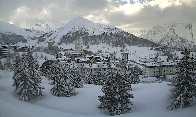
And what a weekend it has been! The last few days have seen huge snowfalls in some parts, especially in the central/eastern Alps where 40-80cm (locally well over 1m) of new snow has fallen at altitude.
Resorts that have done particularly well include Engelberg, St Moritz (Corvatsch), Ischgl, Obergurgl, Sölden, Hintertux, Stubai, Kaprun and Livigno, to name a few. What’s more, the snow has been falling to low altitudes, and at all levels in some northern parts of the Alps.
Updated: 10am Friday 28 April 2017 – Exceptional late season snowfalls for parts of the Alps
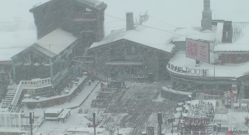
There are some exceptionally wintry scenes across the Alps this morning, where some resorts are in the middle of their biggest snowfall of the “winter” so far!
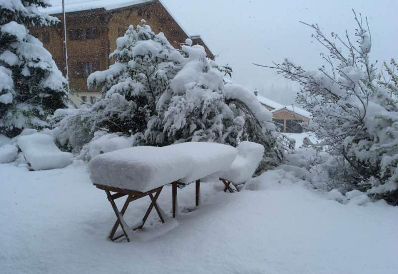 Significant fresh snow at 970m in Morzine this morning – 28 April 2017 – Photo: Kyle James Dickson
Morzine, for example, has woken up to around 20cm this morning, something they haven’t seen much at resort level all winter - too bad the local lifts closed nearly three weeks ago! Other parts of the Alps have even more – with 50cm of new snow up top in Livigno and St Moritz (Corvatsch) in the last 24 hours alone.
 50cm of new snow up top in Livigno – 28 April 2017 – Photo: @Carosello3000
Freezing levels have varied enormously during this storm as warm and cold air battle it out over the Alps. On the northern side it has been snowing to very low levels – right down to the lowlands in places.
Today there will be further snow, heaviest in the central and eastern Swiss Alps as well as parts of Austria. The weather will then clear up tomorrow with some truly exceptional skiing on offer in the handful of resorts still open.
Some good bets include Hintertux, Obergurgl and Ischgl in Austria, St Moritz (Corvatsch) and Zermatt in Switzerland, Val d’Isère, Tignes and Val Thorens in France and Cervinia and Livigno in Italy.
Updated: 8am Wednesday 26 April 2017 - Winter is back!
Weathertoski is in Val d’Isère where we have woken up to fresh snow this morning! Indeed, it is expected to continue snowing on and off all day, with some significant falls possible at altitude.
 Snowing this morning in Val d’Isère – 26 April 2017 – Photo: weathertoski.co.uk
Snow is forecast across many parts of the Alps over the next day or two, heaviest in the higher resorts of the central and eastern Alps (e.g. Passo Tonale, St Moritz, Hintertux).
The weather in the Alps should have improved by the weekend, however, which will make for a fabulous season finale in the likes of Val d’Isère, Ischgl and Obergurgl.
Updated: 12pm Monday 24 April 2017 - Winter isn’t over yet!
It’s a fine spring day in the Alps, but winter is not yet over as further significant snow is forecast for some parts of the Alps this week.
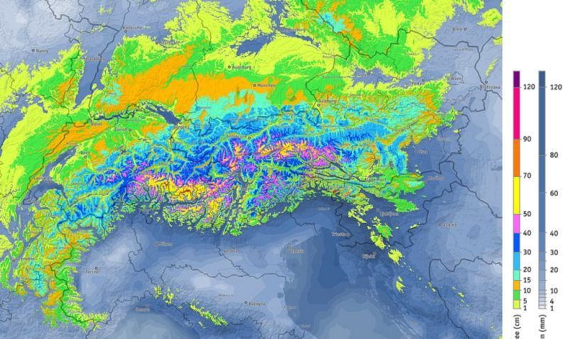 Predicted snowfall (cm) between now and Saturday – Photo: bergfex.com
The weather will start to turn tomorrow and will remain unsettled for most of the week. It will also become much colder mid-week, especially on the northern side of the Alps, where snow could fall to well below 1000m.
However, the heaviest snowfalls over the next few days are likely to be in higher parts of the central Alps, including resorts such as Passo Tonale, Madesimo, St Moritz, Obergurgl, Stubai and Hintertux. These resorts could see between 50cm and 70cm by Friday, with even more possible in some areas.
For most of the Alps the season is over, indeed warm spring weather has led to a rapid thaw of any low-lying snow in recent weeks. Higher up, however, there is still some excellent skiing to be had and, given the forecast, could get even better this week.
Good bets for a final fling this weekend include Val d’Isère and Tignes in France, Zermatt in Switzerland, and Ischgl and Obergurgl in Austria (to name just a few).
Updated: 11am Thursday 20 April 2017 - Near perfect conditions for some north-eastern parts of the Alps!
Some northern-eastern parts of the Alps are experiencing one of their best days of the season so far, with brighter skies today and over 1m of new snow in places!
 Picture perfect in Damüls in the Austrian Vorarlberg this morning, with over 1m of new snow up top – 20 April 2017 – Photo: damuels.at
Some of the biggest snowfalls have been in the Austrian Arlberg (e.g. Lech, Warth and Damüls, pictured below) though many other resorts are also offering incredible conditions, including Engelberg, Ischgl, Hintertux and Obertauern.
 Significant fresh snow in Engelberg – 20 April 2017 – Photo: engelberg.ch
Generally speaking, the western and southern Alps have seen little or no snow over the last few days, but have still benefited from the colder weather.
More flurries are expected in the eastern Alps over the weekend with more widespread snow possible around the middle of next week. Winter is far from over yet!
 Fabulous conditions in Mellau in the Austrian Vorarlberg –– 20 April 2017 – Photo: mellau.at
Updated: 8.45am Wednesday 19 April 2017 - Massive snowfalls in some northern and eastern parts of the Alps
Another 30-50cm of snow has fallen in parts of the Austrian, northern & eastern Swiss, and German Alps in the last 24 hours, bringing 3-day storm totals to well over 1m in places – such as the Austrian Arlberg. Not only that, but the snow has been falling to very low altitudes – as residents of Munich will testify this morning.
 Over 1m of new snow in some north-eastern parts of the Alps in recent days. This is Warth-am-Arlberg – 19 April 2017 – Photo: warth-schroeken.com
Any significant snow over the last few days has been confined to the north-eastern quarter of the Alps, from about central Switzerland eastwards. However, all regions have turned much colder which has put the brakes on the rapid thaw that has been in progress since early March.
Snow showers will continue in many eastern parts of the Alps, both today and tomorrow. These will ease on Friday but return again on Saturday as another (weaker) cold front moves down from the north. During this time many western and southern parts of the Alps will stay mostly fine, if rather chilly. However, it looks likely that another potent wintry blast will affect the Alps more widely around the middle of next week.
In the meantime, if you are lucky enough to be out in the Alps later this week or this weekend, there will be some excellent skiing on offer in the resorts still open, especially in Austria (away from the far south) and in central/eastern Switzerland. Good bets for powder include Engelberg, St Anton, Stubai, Kaprun, Hintertux and Obertauern, to name just a few.
Updated: 8.30am Tuesday 18 April 2017 – Winter is back, especially in Austria!
Last week may have been mostly warm and sunny, but it has since turned much colder in the Alps with significant snow in places.
 Blizzarding in Lech this morning – 18 April 2017 – Photo: lech.com
This dramatic change in the weather comes courtesy of a mass of arctic air that flooded the Alps over the weekend, dropping the temperature by as much as 20°C in places! It has also brought snow, chiefly to the north and east of the Alps where 50cm+ has already fallen in some areas. However, with more expected over the next couple of days, some parts of Austria could see storm totals of over 1m by Thursday with the snow falling to low altitudes (400-700m) at times.
Resorts that have or will benefit from this significant late snowfall (once the weather settles down) are mostly in Austria, including St Anton, Lech, Obergurgl, Obertauern, Ischgl, Kaprun and Hintertux. Resorts still open in the southern and western Alps (e.g. Val d’Isère, Val Thorens, Zermatt, Cervinia) have seen little or no snow, but have still benefited from the dramatic drop in temperature.
Sunny weather will return to all parts later in the week. However, another blast of arctic air is expected to bring further heavy snow to many parts of the Alps next week, again favouring the north and east. Winter is far from over!
Updated: 7.30am Friday 14 April 2017 - Colder weather is on its way
Weathertoski is in Val Cenis (courtesy of Peak Retreats), where it has been warm and sunny virtually all week. The weather is on the change, however, as colder air floods down from the north this weekend. It won’t deliver much in the way of snow to the French Alps, but we will see something of a return to winter for some north-eastern parts of the Alps, notably Austria.
 Fantastic skiing in Bonneval-sur-Arc yesterday – Photo: weathertoski.co.uk
Before this change in the weather, most of the Alps are looking another warm and sunny day today which means hard snow conditions early on followed by a softening up process, the rate of which is dependent on altitude and orientation.
We skied Bonneval-sur-Arc yesterday (just up the valley from Val Cenis) where it was possible to ski cold “wintry” snow all day long on the upper slopes (above 2600m or so). Lower down you have to time your runs right – east-facing first followed by south-facing (best mid-morning) then west-facing (midday).
Generally speaking, snow cover in the Alps is now very patchy below 2000m, with many low resorts either struggling or already closed. If you are still planning to sneak in a late ski holiday next week, you need to aim for a resort with plenty of terrain above 2300m - such as Val Thorens, Tignes, Val d’Isère, Cervinia, Zermatt, Saas-Fee, Obergurgl, Ischgl and Hintertux (to name a few).
As mentioned earlier, you might even get some powder, especially in Austria. It will also be noticeably colder than it has been recently, with snow falling as low as 1000m in some eastern parts of the Alps.
Updated: 7.25am Wednesday 12 April 2017 - Mostly fine
Weathertoski is in Val Cenis (courtesy of Peak Retreats), where we are looking forward to another mostly sunny day. Indeed, it has been mostly sunny all week, with cold clear nights followed by warm afternoon temperatures (as high as +20°C at 1400m).
 Fabulous spring snow conditions at altitude in Val Cenis yesterday – Photo: weathertoski.co.uk
Elsewhere in the Alps there have been a few showers here and there - thanks to some weak weather fronts over the last 24 hours - but no meaningful snow, and many areas have remained dry.
In short, spring snow conditions continue to rule with the most consistent snow quality in resorts with plenty of north-facing terrain above 2300m, preferably even higher.
Updated: 8.10am Monday 10 April 2017 – Still mostly sunny, with a dusting of snow due in some north-eastern parts of the Alps tonight.
Weathertoski is in Val Cenis (courtesy of Peak Retreats), where the weather is clear and cold first thing this morning. Like most of the Alps, we are looking forward to typical spring snow conditions today, with hard pistes early on, softening up as the day progresses at a rate dependent on altitude and orientation.
 Great spring snow conditions in Val Cenis yesterday – Photo: weathertoski.co.uk
Snow conditions here in Val Cenis in the Haute Maurienne are still surprisingly good given how warm it has been, though you do have to bear in mind the freeze-thaw cycle. On Sunday the lower slopes were icy for the first hour or two, very skiable mid-morning, then turned slushy before midday. Higher up the snow was firmer for longer, eventually succumbing in most areas by late afternoon. Above about 2500m the snow remained firm all day long.
With regards to snow depths, there maybe next to no snow at valley level but there is still around 2.5m at 2800m, which is more than there is at similar altitudes in most other parts of the Alps - thanks to huge localised snowfalls earlier in the season.
Over the next few days it will turn a little bit more unsettled, with some snow for northern and north-eastern parts of the Alps (i.e. eastern Switzerland and Austria). However, it is not expected to fall in any great quantity, and many southern and western areas will stay dry. Temperatures will also drop a fraction, but not to any significant degree.
Updated: 8.10am Sunday 9 April 2017 - Warm and sunny
Weathertoski is in Val Cenis (courtesy of Peak Retreats) where the weather is clear and cold first thing this morning. Like most of the Alps, we are looking forward to typical spring snow conditions today, with hard pistes early on, softening up as the day progresses at a rate dependent on altitude and orientation. More on conditions in Val Cenis later today…
 Cold and frosty first thing this morning in Val Cenis, but it will soon warm up – 9 April 2017 – Photo: weathertoski.co.uk
Over the next few days it will turn a little bit more unsettled, with some snow for northern and north-eastern parts of the Alps (i.e. eastern Switzerland and Austria). However, it is not expected to fall in any great quantity and many southern and western areas will stay dry. Temperatures will also drop a little, after another very warm afternoon today.
Updated: 8.15am Thursday 6 April 2017 - Mostly dry, with a few showers in the north and east
The weather in the Alps is still fairly mixed. Yesterday the focus for most of the showers was in the south-west, with a further top-up of snow at altitude here and there. Today the western Alps will be mostly dry, while the north-eastern Alps (i.e. Austria) will see some showers (snow 1200-1500m).
 Fabulous snow conditions at altitude in the western Alps. This is Val Thorens – 6 April 2017 – Photo: valthorens.com
Over the next few days there will be plenty of dry and sunny weather around with just the odd shower here and there, especially in the east.
The best snow conditions remain at high altitude in the western Alps (e.g. Cervinia, Monte Rosa, Saas-Fee, Val d’Isère, Val Thorens, Sestriere). Lower down, natural snow cover is generally patchy everywhere, and some ski areas (e.g. Ski Welt) are now closed for the season.
Updated: 9.30am Tuesday 4 April 2017 - Mixed weather
The weather in the Alps is quite mixed today. In the northern and especially eastern Alps there will be some showers, these most frequent between the central Austrian Alps and the Dolomites (snow 1500-1700m). Elsewhere, except for the odd shower, there will be plenty of dry weather with the best of the sunshine in the southern French and western Italian Alps.
 Great weather and conditions in Montgenèvre – 4 April 2017 – Photo: montgenevre.com
On Wednesday there will further (mostly light) showers in the eastern Alps and perhaps also the far southern French and south-western Italian Alps. Any snowfall totals will be modest, however, and most places will stay dry.
There is still lots of good skiing to be had in the higher Alpine resorts right now, especially in the west. If we were to pick some of the very best options they would include Val d’Isère, Tignes, Val Thorens, Cervinia, Zermatt and Saas-Fee.
Generally speaking, however, spring snow conditions are the order of the day, with the most pronounced freeze-thaw cycles the lower and more exposed to the sun you are. Note also that there is very little if any natural in the lowest resorts with some major areas (e.g. Ski Welt) now closed for the season.
Updated: 8.30am Monday 3 April 2017 - Powder day for some south-western parts of the Alps
Snow conditions in the Alps are highly contrasting today, following significant snow for some south-western parts of the Alps over the weekend.
 Lots of fresh snow in Sestriere this morning – 3 April 2017 – Photo: vialattea.it
Generally speaking, the heaviest snow fell close to the French/Italian border from about Val d’Isère southwards. According to Radio Val d’Isère, 110cm of new snow fell on the Pisaillas glacier over the weekend. Other areas that have done well include Bonneval-sur-Arc, Val Cenis, the Milky Way (e.g. Sestriere), Cervinia and the Monte Rosa region.
Most of the Alps, however, saw little if any precipitation over the weekend, with snow conditions remaining predominantly spring-like. Indeed, some low ski areas are now closed for the season, including the Ski Welt in Austria and much of the Sella Ronda in Italy.
This week’s weather will remain fairly mixed across the Alps. There will be plenty of fine and sunny weather on offer, but also a few showers here and there. Most of these showers are expected to fall across the eastern Alps (especially mid-week) but significant new snow is not expected.
Updated: 10.10am Sunday 2 April 2017 - Significant new snow for some south-western parts of the Alps
As expected, it has been snowing in some south-western parts of the Alps. The heaviest snow has been falling close to the French-Italian border from about Val d’Isère southwards.
 Plenty of fresh snow again for Val d’Isère – 2 April 2017 – Photo: valdisere.com
Indeed, this morning Val d’Isère itself reports 18cm of new snow in the village and as much as 40cm up on the Pisaillas glacier. Other resorts that have significant new snow (at least at altitude) include Bonneval-sur-Arc, Val Cenis, Sestriere, Montgenèvre, Pila, Cervinia, Zermatt, Saas-Fee and the Monte Rosa region, to name a few, The rain/snow limit has generally been between 1500m and 1800m, but a bit lower in some western Italian valleys.
Elsewhere in the Alps – that is to say most of the northern French Alps, most of Switzerland (away from the far south-west), the central and eastern Italian Alps and Austria - this weekend has been mostly dry and relatively mild.
Next week the weather will remain more unsettled than originally anticipated a few days ago. There will be lots of fine weather, especially in the southern and western Alps. However, there will also be some showers, especially in the northern and eastern Alps mid-week (e.g. Arlberg) with some snow above 1400-1700m.